ATL: IRENE - Remnants - Discussion
Moderator: S2k Moderators
-
eastcoastFL

- Category 5

- Posts: 3996
- Age: 44
- Joined: Thu Apr 12, 2007 12:29 pm
- Location: Palm City, FL
bottom line is I would like to see irene stay far enough off the coast to not harm anyone but close enough to get me and my wife out of work thurs and fri! Too much to ask?
0 likes
Personal Forecast Disclaimer:
The posts in this forum are NOT official forecast and should not be used as such. They are just the opinion of the poster and may or may not be backed by sound meteorological data. They are NOT endorsed by any professional institution or storm2k.org. For official information, please refer to the NHC and NWS products.
The posts in this forum are NOT official forecast and should not be used as such. They are just the opinion of the poster and may or may not be backed by sound meteorological data. They are NOT endorsed by any professional institution or storm2k.org. For official information, please refer to the NHC and NWS products.

Re: ATL: IRENE - Hurricane - Discussion
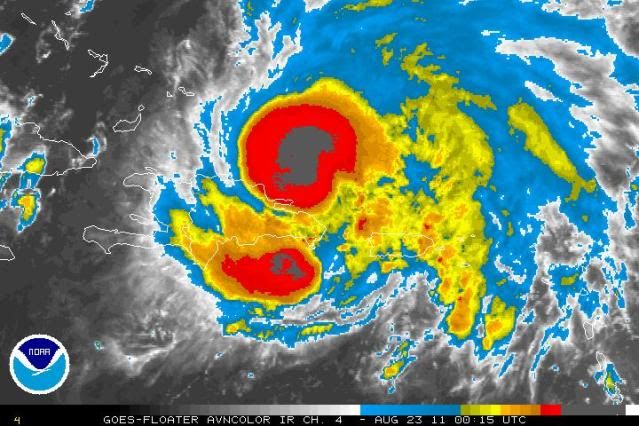
Note the two white dots near the center of circulation, indicative of severe convective activity:

I suspect we may see quite a bit more of that later tonight.
Pray for the Bahamas, peeps.
I suspect we may see quite a bit more of that later tonight.
Pray for the Bahamas, peeps.
0 likes
-
ozonepete
- Professional-Met

- Posts: 4743
- Joined: Mon Sep 07, 2009 3:23 pm
- Location: From Ozone Park, NYC / Now in Brooklyn, NY
Re: ATL: IRENE - Hurricane - Discussion
Wow is that an impressive core and CDO. Look at all of those really cold cloud tops, and DMAX for overnight is only beginning!
0 likes
-
CrazyC83
- Professional-Met
- Posts: 34315
- Joined: Tue Mar 07, 2006 11:57 pm
- Location: Deep South, for the first time!
000
URNT15 KNHC 230051
AF303 0709A IRENE HDOB 17 20110823
004100 1947N 06921W 6969 03101 //// +120 //// 358038 039 051 000 01
004130 1947N 06919W 6968 03096 //// +120 //// 003038 039 050 000 01
004200 1947N 06918W 6965 03095 //// +129 //// 004040 041 049 000 05
004230 1947N 06916W 6967 03088 //// +124 //// 002038 040 055 001 01
004300 1947N 06914W 6975 03065 //// +124 //// 358043 051 060 012 01
004330 1947N 06912W 6975 03055 //// +121 //// 350055 057 065 023 01
004400 1947N 06910W 6969 03054 //// +105 //// 342048 053 067 017 01
004430 1946N 06908W 6980 03019 //// +120 //// 331055 060 066 014 01
004500 1946N 06906W 6986 03008 //// +118 //// 331046 049 /// /// 05
004530 1947N 06904W 6939 03058 //// +140 //// 338033 037 060 005 01
004600 1948N 06902W 6970 03018 //// +154 //// 341024 027 055 002 01
004630 1948N 06900W 6974 02998 //// +167 //// 345019 023 040 001 05
004700 1949N 06859W 6968 02998 //// +163 //// 009011 013 022 000 05
004730 1949N 06857W 6962 02994 //// +155 //// 002008 011 012 000 05
004800 1949N 06855W 6970 02982 //// +157 //// 002005 006 008 000 05
004830 1949N 06853W 6967 02981 //// +160 //// 263003 004 016 000 01
004900 1949N 06851W 6967 02986 //// +161 //// 188003 007 007 000 01
004930 1949N 06849W 6967 02981 //// +155 //// 149011 012 017 000 05
005000 1950N 06847W 6962 02986 //// +153 //// 161021 026 048 001 05
005030 1952N 06846W 6972 02985 //// +141 //// 154032 036 059 001 01
$$
;
Hurricane conditions now spread all the way around.
0 likes
-
SunnyThoughts
- Category 5
- Posts: 2263
- Joined: Wed Jul 09, 2003 12:42 pm
- Location: Pensacola, Florida

Re: ATL: IRENE - Hurricane - Discussion
Man, the Turks and Caicos is going to get absolutely pounded. Such a beautiful island, I stayed at the Beaches (Sandals) resort there last year...
0 likes
-
SunnyThoughts
- Category 5
- Posts: 2263
- Joined: Wed Jul 09, 2003 12:42 pm
- Location: Pensacola, Florida
-
ozonepete
- Professional-Met
- Posts: 4743
- Joined: Mon Sep 07, 2009 3:23 pm
- Location: From Ozone Park, NYC / Now in Brooklyn, NY
Re:
SunnyThoughts wrote:I wonder how long it will take to get that eyewall completely established and cleared out? Overnight tonight you guys think? Or sometime tomorrow?
From following these for a lot of years, it wouldn't surprise me to see one within the next few hours. The eye very often becomes apparent when winds are between 90 and 100 mph, so it's time.
0 likes
-
Dave

- Retired Staff

- Posts: 13442
- Age: 75
- Joined: Tue Aug 01, 2006 3:57 pm
- Location: Milan Indiana
- Contact:

0 likes
This post is NOT AN OFFICIAL FORECAST and should not be used as such. It is just the opinion of the poster and may or may not be backed by sound meteorological data. It is NOT endorsed by any professional institution including storm2k.org. For Official Information please refer to the NHC and NWS products.
-
HurricaneWarning92
- Category 2

- Posts: 520
- Joined: Sat Jul 23, 2011 4:33 pm
- Location: Pembroke Pines, S. Florida (Lat: 26.00N, Lon: 80.22W)
Re:
eastcoastFL wrote:The weather channel was showing that yellow line that shows the movement of the storm since its birth and the last few hours went west north west then dipped sw a bit at the end.
I believe i saw that too..
0 likes
The posts in this forum are NOT official forecast and should not be used as such. They are just the opinion of the poster and may or may not be backed by sound meteorological data. They are NOT endorsed by any professional institution or storm2k.org. For official information, please refer to the NHC and NWS products.
-
CrazyC83
- Professional-Met
- Posts: 34315
- Joined: Tue Mar 07, 2006 11:57 pm
- Location: Deep South, for the first time!
000
URNT15 KNHC 230101
AF303 0709A IRENE HDOB 18 20110823
005100 1953N 06845W 6968 03002 //// +132 //// 153045 048 059 000 05
005130 1954N 06843W 6965 03023 //// +125 //// 149050 050 067 001 05
005200 1956N 06842W 6966 03029 //// +113 //// 149054 057 066 001 01
005230 1957N 06840W 6971 03032 //// +111 //// 151059 062 061 001 01
005300 1958N 06839W 6960 03057 //// +092 //// 156072 075 061 000 01
005330 2000N 06838W 6967 03061 //// +074 //// 152075 077 061 003 01
005400 2001N 06836W 6972 03066 //// +084 //// 152072 073 059 005 01
005430 2002N 06835W 6962 03089 //// +094 //// 150070 072 055 003 01
005500 2004N 06834W 6967 03090 //// +090 //// 147068 069 056 002 01
005530 2005N 06832W 6970 03094 //// +092 //// 146064 066 053 006 01
005600 2006N 06831W 6965 03107 //// +094 //// 143063 064 052 002 01
005630 2008N 06830W 6966 03111 //// +092 //// 144063 064 051 001 01
005700 2009N 06828W 6967 03109 //// +089 //// 146060 062 050 002 01
005730 2010N 06827W 6967 03117 //// +092 //// 146057 058 049 002 01
005800 2011N 06825W 6967 03122 //// +092 //// 144054 055 050 003 01
005830 2013N 06824W 6966 03122 //// +092 //// 144053 053 049 006 01
005900 2014N 06823W 6966 03125 //// +075 //// 144056 059 054 015 01
005930 2015N 06821W 6967 03126 //// +075 //// 138056 061 056 017 01
010000 2017N 06820W 6969 03122 //// +071 //// 137059 064 052 030 01
010030 2018N 06819W 6967 03126 //// +074 //// 135060 063 059 024 01
$$
;
0 likes
-
ozonepete
- Professional-Met
- Posts: 4743
- Joined: Mon Sep 07, 2009 3:23 pm
- Location: From Ozone Park, NYC / Now in Brooklyn, NY
Re: ATL: IRENE - Hurricane - Discussion
Impressive strengthening from 17Z (1PM) today to now:


0 likes
-
TheShrimper
- Category 2
- Posts: 516
- Joined: Sun Aug 01, 2004 5:05 pm
-
Dave
- Retired Staff
- Posts: 13442
- Age: 75
- Joined: Tue Aug 01, 2006 3:57 pm
- Location: Milan Indiana
- Contact:

0 likes
This post is NOT AN OFFICIAL FORECAST and should not be used as such. It is just the opinion of the poster and may or may not be backed by sound meteorological data. It is NOT endorsed by any professional institution including storm2k.org. For Official Information please refer to the NHC and NWS products.
-
SouthDadeFish

- Professional-Met
- Posts: 2835
- Joined: Thu Sep 23, 2010 2:54 pm
- Location: Miami, FL
- Contact:

-
Dave
- Retired Staff
- Posts: 13442
- Age: 75
- Joined: Tue Aug 01, 2006 3:57 pm
- Location: Milan Indiana
- Contact:
000
URNT12 KNHC 230101
VORTEX DATA MESSAGE AL092011
A. 23/00:49:00Z
B. 19 deg 49 min N
068 deg 51 min W
C. 700 mb 2944 m
D. 71 kt
E. 269 deg 92 nm
F. 329 deg 60 kt
G. 259 deg 15 nm
H. 981 mb
I. 11 C / 3047 m
J. 17 C / 3050 m
K. NA / NA
L. NA
M. NA
N. 12345 / 7
O. 0.02 / 3 nm
P. AF303 0709A IRENE OB 08
MAX FL WIND 107 KT NW QUAD 23:30:20Z
MAX FL TEMP 17 C 266 / 7 NM FROM FL CNTR
;
0 likes
-
Dave
- Retired Staff
- Posts: 13442
- Age: 75
- Joined: Tue Aug 01, 2006 3:57 pm
- Location: Milan Indiana
- Contact:
DECODED VDM
Product: Air Force Vortex Message (URNT12 KNHC)
Transmitted: 23rd day of the month at 01:01Z
Aircraft: Air Force Aircraft (Last 3 digits of the tail number are 303)
Storm Number & Year: 09L in 2011
Storm Name: Irene (flight in the North Atlantic basin)
Mission Number: 7
Observation Number: 08
A. Time of Center Fix: 23rd day of the month at 0:49:00Z
B. Center Fix Coordinates: 19°49'N 68°51'W (19.8167N 68.85W)
B. Center Fix Location: 115 miles (185 km) to the NE (36°) from Santo Domingo, Dominican Republic.
C. Minimum Height at Standard Level: 2,944m (9,659ft) at 700mb
D. Estimated (by SFMR or visually) Maximum Surface Wind: 71kts (~ 81.7mph)
E. Location of the Estimated Maximum Surface Wind: 92 nautical miles (106 statute miles) to the W (269°) of center fix
F. Maximum Flight Level Wind Inbound: From 329° at 60kts (From the NNW at ~ 69.0mph)
G. Location of Maximum Flight Level Wind Inbound: 15 nautical miles (17 statute miles) to the WSW/W (259°) of center fix
H. Minimum Sea Level Pressure: 981mb (28.97 inHg)
I. Maximum Flight Level Temp & Pressure Altitude Outside Eye: 11°C (52°F) at a pressure alt. of 3,047m (9,997ft)
J. Maximum Flight Level Temp & Pressure Altitude Inside Eye: 17°C (63°F) at a pressure alt. of 3,050m (10,007ft)
K. Dewpoint Temp & Sea Surface Temp (collected at same location as temp inside eye): Not Available
L. Eye Character: Not Available
M. Eye Shape: Not Available
N. Fix Determined By: Penetration, Radar, Wind, Pressure and Temperature
N. Fix Level: 700mb
O. Navigation Fix Accuracy: 0.02 nautical miles
O. Meteorological Accuracy: 3 nautical miles
Remarks Section:
Maximum Flight Level Wind: 107kts (~ 123.1mph) in the northwest quadrant at 23:30:20Z
Maximum Flight Level Temp: 17°C (63°F) which was observed 7 nautical miles to the W (266°) from the flight level center
0 likes
This post is NOT AN OFFICIAL FORECAST and should not be used as such. It is just the opinion of the poster and may or may not be backed by sound meteorological data. It is NOT endorsed by any professional institution including storm2k.org. For Official Information please refer to the NHC and NWS products.
-
Dave
- Retired Staff
- Posts: 13442
- Age: 75
- Joined: Tue Aug 01, 2006 3:57 pm
- Location: Milan Indiana
- Contact:
000
UZNT13 KNHC 230101
XXAA 73017 99198 70688 04398 99981 27417 13015 00673 ///// /////
92518 24015 13512 85258 21428 13512 70938 16262 14009 88999 77999
31313 09608 80049
61616 AF303 0709A IRENE OB 09
62626 EYE SPL 1983N06884W 0053 MBL WND 14013 AEV 20802 DLM WND 12
511 980697 WL150 14014 083 REL 1982N06883W 004918 SPG 1983N06884W
005318 =
XXBB 73018 99198 70688 04398 00981 27417 11856 20816 22850 21428
33832 23256 44721 17457 55697 16063
21212 00981 13015 11971 14515 22908 13511 33850 13512 44828 14013
55772 09513 66697 14009
31313 09608 80049
61616 AF303 0709A IRENE OB 09
62626 EYE SPL 1983N06884W 0053 MBL WND 14013 AEV 20802 DLM WND 12
511 980697 WL150 14014 083 REL 1982N06883W 004918 SPG 1983N06884W
005318 =
;
0 likes
-
Blown Away

- S2K Supporter

- Posts: 10253
- Joined: Wed May 26, 2004 6:17 am
Re: ATL: IRENE - Hurricane - Discussion
cycloneye wrote:Hey peeps,I am back as power,internet and phones came back tonight. I survived Irene with no problems at house,but I didn't expect to see the stars in my location as eye moved over me.
Glad your good!! Being in the eye is an amazing zen like feeling!!
0 likes
Hurricane Eye Experience: David 79, Irene 99, Frances 04, Jeanne 04, Wilma 05… Hurricane Brush Experience: Andrew 92, Erin 95, Floyd 99, Matthew 16, Irma 17, Ian 22, Nicole 22…
-
Dave
- Retired Staff
- Posts: 13442
- Age: 75
- Joined: Tue Aug 01, 2006 3:57 pm
- Location: Milan Indiana
- Contact:
DECODED DROPSONDE
Code: Select all
Product: Air Force Temp Drop (Dropsonde) Message (UZNT13 KNHC)
Transmitted: 23rd day of the month at 01:01Z
Aircraft: Air Force Aircraft (Last 3 digits of the tail number are 303)
Storm Number: 09
Storm Name: Irene (flight in the North Atlantic basin)
Mission Number: 7
Observation Number: 09

Part A...


Date: Near the closest hour of 1Z on the 23rd day of the month
Highest Mandatory Level For Which Wind Was Reported: 700mb
Coordinates: 19.8N 68.8W
Location: 116 miles (187 km) to the NE (38°) from Santo Domingo, Dominican Republic.
Marsden Square: 043 (About)

Level Geo. Height Air Temp. Dew Point Wind Direction Wind Speed
981mb (28.97 inHg) Sea Level (Surface) 27.4°C (81.3°F) 25.7°C (78.3°F) 130° (from the SE) 15 knots (17 mph)
1000mb -173m (-568 ft) Other data not available.
925mb 518m (1,699 ft) 24.0°C (75.2°F) 22.5°C (72.5°F) 135° (from the SE) 12 knots (14 mph)
850mb 1,258m (4,127 ft) 21.4°C (70.5°F) 18.6°C (65.5°F) 135° (from the SE) 12 knots (14 mph)
700mb 2,938m (9,639 ft) 16.2°C (61.2°F) Approximately 4°C (39°F) 140° (from the SE) 9 knots (10 mph)

Information About Radiosonde:
- Launch Time: 0:49Z
- About Sonde: A descending radiosonde tracked automatically by satellite navigation with no solar or infrared correction.

Remarks Section...


Dropsonde Location: Dropped in eye.

Splash Location: 19.83N 68.84W
Splash Time: 0:53Z

Release Location: 19.82N 68.83W View map)
Release Time: 0:49:18Z

Splash Location: 19.83N 68.84W (
Splash Time: 0:53:18Z

Mean Boundary Level Wind (mean wind in the lowest 500 geopotential meters of the sounding):
- Wind Direction: 140° (from the SE)
- Wind Speed: 13 knots (15 mph)

Deep Layer Mean Wind (average wind over the depth of the sounding):
- Wind Direction: 125° (from the SE)
- Wind Speed: 11 knots (13 mph)
- Depth of Sounding: From 697mb to 980mb

Average Wind Over Lowest Available 150 geopotential meters (gpm) of the sounding:
- Lowest 150m: 158 gpm - 8 gpm (518 geo. feet - 26 geo. feet)
- Wind Direction: 140° (from the SE)
- Wind Speed: 14 knots (16 mph)

Sounding Software Version: AEV 20802


Part B: Data For Significant Levels...


Significant Temperature And Relative Humidity Levels...
Level Air Temperature Dew Point
981mb (Surface) 27.4°C (81.3°F) 25.7°C (78.3°F)
856mb 20.8°C (69.4°F) 19.2°C (66.6°F)
850mb 21.4°C (70.5°F) 18.6°C (65.5°F)
832mb 23.2°C (73.8°F) Approximately 17°C (63°F)
721mb 17.4°C (63.3°F) Approximately 10°C (50°F)
697mb 16.0°C (60.8°F) Approximately 3°C (37°F)

Significant Wind Levels...
Level Wind Direction Wind Speed
981mb (Surface) 130° (from the SE) 15 knots (17 mph)
971mb 145° (from the SE) 15 knots (17 mph)
908mb 135° (from the SE) 11 knots (13 mph)
850mb 135° (from the SE) 12 knots (14 mph)
828mb 140° (from the SE) 13 knots (15 mph)
772mb 95° (from the E) 13 knots (15 mph)
697mb 140° (from the SE) 9 knots (10 mph)
0 likes
This post is NOT AN OFFICIAL FORECAST and should not be used as such. It is just the opinion of the poster and may or may not be backed by sound meteorological data. It is NOT endorsed by any professional institution including storm2k.org. For Official Information please refer to the NHC and NWS products.
Who is online
Users browsing this forum: No registered users and 6 guests