ATL: IRENE - Models
Moderator: S2k Moderators

Agreed GCANe, i suspect 115-120kts sound sabout right as per the NHC forecast, would be a very powerful hurricane indeed capable of bad damage on either flank of the hurricane.
0 likes
Personal Forecast Disclaimer:
The posts in this forum are NOT official forecast and should not be used as such. They are just the opinion of the poster and may or may not be backed by sound meteorological data. They are NOT endorsed by any professional institution or storm2k.org. For official information, please refer to the NHC and NWS products
The posts in this forum are NOT official forecast and should not be used as such. They are just the opinion of the poster and may or may not be backed by sound meteorological data. They are NOT endorsed by any professional institution or storm2k.org. For official information, please refer to the NHC and NWS products
Re: ATL: IRENE - Models
I believe the HMRF and GDFL are up next. Where is the best place to watch them as they load?
0 likes
-
SEASON_CANCELED

- Category 3

- Posts: 887
- Joined: Mon Jul 06, 2009 5:17 am
- Location: 8 Bit Charlie Sheen
Re: ATL: IRENE - Models
Im not convinced of these models yet.
I want to see the ridging is all. This is awfully apocalyptic
I want to see the ridging is all. This is awfully apocalyptic
0 likes
i am a big stupid ugly moron with an ugly face and a big butt and my butt stinks and i like to kiss my own butt
-
HurricaneWarning92
- Category 2

- Posts: 520
- Joined: Sat Jul 23, 2011 4:33 pm
- Location: Pembroke Pines, S. Florida (Lat: 26.00N, Lon: 80.22W)
Has the ridge weakened at all? i just still find it odd that the trough is gonna be strong enough to lift it and make such a turn... its August.
0 likes
The posts in this forum are NOT official forecast and should not be used as such. They are just the opinion of the poster and may or may not be backed by sound meteorological data. They are NOT endorsed by any professional institution or storm2k.org. For official information, please refer to the NHC and NWS products.
Re: ATL: IRENE - Models
SEASON_CANCELED wrote:Im not convinced of these models yet.
I want to see the ridging is all. This is awfully apocalyptic
With the new atmospheric data ingested in the 00Z models I think they have a pretty good grip on the synoptics (ridging and troughing). I think the only thing at this point that could cause any wild deviation from the current models is interaction with DR/Haiti. If Irene gets hung up on the coast or even pulled WSW along the coast (like Debby back in 2000) it could delay the turn and make things a wee bit more interesting for FL
0 likes
-
SEASON_CANCELED
- Category 3
- Posts: 887
- Joined: Mon Jul 06, 2009 5:17 am
- Location: 8 Bit Charlie Sheen
Re: ATL: IRENE - Models
jhpigott wrote:SEASON_CANCELED wrote:Im not convinced of these models yet.
I want to see the ridging is all. This is awfully apocalyptic
With the new atmospheric data ingested in the 00Z models I think they have a pretty good grip on the synoptics (ridging and troughing). I think the only thing at this point that could cause any wild deviation from the current models is interaction with DR/Haiti. If Irene gets hung up on the coast or even pulled WSW along the coast (like Debby back in 2000) it could delay the turn and make things a wee bit more interesting for FL
I just dont see it Turning NNW in the next 24 hours is all from its present position. I think our cone goes back west a notch. But im not a scientician and this is just a amatuer guess. I see it got blasted a bit on DR and I say it trends west a bit more than expected..
0 likes
i am a big stupid ugly moron with an ugly face and a big butt and my butt stinks and i like to kiss my own butt
-
deltadog03

- Professional-Met

- Posts: 3580
- Joined: Tue Jul 05, 2005 6:16 pm
- Location: Macon, GA
-
SEASON_CANCELED
- Category 3
- Posts: 887
- Joined: Mon Jul 06, 2009 5:17 am
- Location: 8 Bit Charlie Sheen
Re:
Pretty Similiar imo

Thats 1996 Bertha for anyone who remembers. Just a clip S presently of where it is now.
Thats 1996 Bertha for anyone who remembers. Just a clip S presently of where it is now.
0 likes
i am a big stupid ugly moron with an ugly face and a big butt and my butt stinks and i like to kiss my own butt
Re: ATL: IRENE - Models
06Z HWRF stats and wind swath
ATTENTION...NATIONAL HURRICANE CENTER
NCEP COUPLED HWRF HURRICANE MODEL FORECAST MADE FOR
HURRICANE IRENE 09L
INITIAL TIME 6Z AUG 23
FORECAST POSITIONS (FROM STATS.SHORT FILE...)
HOUR LATITUDE LONGITUDE MIN PRESS (hPa) MAX SFC WIND (KTS)
HOUR: 0.0 LONG: -69.70 LAT: 20.10 MIN PRESS (hPa): 965.00 MAX SURF WIND (KNOTS): 81.00
HOUR: 6.0 LONG: -70.70 LAT: 20.40 MIN PRESS (hPa): 966.00 MAX SURF WIND (KNOTS): 81.00
HOUR: 12.0 LONG: -71.40 LAT: 20.70 MIN PRESS (hPa): 967.00 MAX SURF WIND (KNOTS): 69.00
HOUR: 18.0 LONG: -72.20 LAT: 20.70 MIN PRESS (hPa): 962.00 MAX SURF WIND (KNOTS): 75.00
HOUR: 24.0 LONG: -72.70 LAT: 21.00 MIN PRESS (hPa): 949.00 MAX SURF WIND (KNOTS): 83.00
HOUR: 30.0 LONG: -73.30 LAT: 21.60 MIN PRESS (hPa): 951.00 MAX SURF WIND (KNOTS): 86.00
HOUR: 36.0 LONG: -74.10 LAT: 22.30 MIN PRESS (hPa): 949.00 MAX SURF WIND (KNOTS): 85.00
HOUR: 42.0 LONG: -74.80 LAT: 23.00 MIN PRESS (hPa): 948.00 MAX SURF WIND (KNOTS): 96.00
HOUR: 48.0 LONG: -75.60 LAT: 23.90 MIN PRESS (hPa): 944.00 MAX SURF WIND (KNOTS): 94.00
HOUR: 54.0 LONG: -76.20 LAT: 24.80 MIN PRESS (hPa): 942.00 MAX SURF WIND (KNOTS): 99.00
HOUR: 60.0 LONG: -76.60 LAT: 25.90 MIN PRESS (hPa): 940.00 MAX SURF WIND (KNOTS): 101.00
HOUR: 66.0 LONG: -77.00 LAT: 26.90 MIN PRESS (hPa): 939.00 MAX SURF WIND (KNOTS): 96.00
HOUR: 72.0 LONG: -77.30 LAT: 28.00 MIN PRESS (hPa): 936.00 MAX SURF WIND (KNOTS): 101.00
HOUR: 78.0 LONG: -77.50 LAT: 29.00 MIN PRESS (hPa): 937.00 MAX SURF WIND (KNOTS): 98.00
HOUR: 84.0 LONG: -77.70 LAT: 29.90 MIN PRESS (hPa): 935.00 MAX SURF WIND (KNOTS): 94.00
HOUR: 90.0 LONG: -77.60 LAT: 30.60 MIN PRESS (hPa): 936.00 MAX SURF WIND (KNOTS): 93.00
HOUR: 96.0 LONG: -77.70 LAT: 31.60 MIN PRESS (hPa): 930.00 MAX SURF WIND (KNOTS): 100.00
HOUR: 102.0 LONG: -77.50 LAT: 32.50 MIN PRESS (hPa): 930.00 MAX SURF WIND (KNOTS): 100.00
HOUR: 108.0 LONG: -77.60 LAT: 33.40 MIN PRESS (hPa): 927.00 MAX SURF WIND (KNOTS): 106.00
HOUR: 114.0 LONG: -77.40 LAT: 34.20 MIN PRESS (hPa): 932.00 MAX SURF WIND (KNOTS): 91.00
HOUR: 120.0 LONG: -77.10 LAT: 35.10 MIN PRESS (hPa): 937.00 MAX SURF WIND (KNOTS): 84.00
HOUR: 126.0 LONG: -76.60 LAT: 36.10 MIN PRESS (hPa): 943.00 MAX SURF WIND (KNOTS): 81.00
FORECAST RAN UNCOUPLED

0 likes
-
SEASON_CANCELED
- Category 3
- Posts: 887
- Joined: Mon Jul 06, 2009 5:17 am
- Location: 8 Bit Charlie Sheen
Re: ATL: IRENE - Models
clfenwi wrote:06Z HWRF stats and wind swath
ATTENTION...NATIONAL HURRICANE CENTER
NCEP COUPLED HWRF HURRICANE MODEL FORECAST MADE FOR
HURRICANE IRENE 09L
INITIAL TIME 6Z AUG 23
FORECAST POSITIONS (FROM STATS.SHORT FILE...)
HOUR LATITUDE LONGITUDE MIN PRESS (hPa) MAX SFC WIND (KTS)
HOUR: 0.0 LONG: -69.70 LAT: 20.10 MIN PRESS (hPa): 965.00 MAX SURF WIND (KNOTS): 81.00
HOUR: 6.0 LONG: -70.70 LAT: 20.40 MIN PRESS (hPa): 966.00 MAX SURF WIND (KNOTS): 81.00
HOUR: 12.0 LONG: -71.40 LAT: 20.70 MIN PRESS (hPa): 967.00 MAX SURF WIND (KNOTS): 69.00
HOUR: 18.0 LONG: -72.20 LAT: 20.70 MIN PRESS (hPa): 962.00 MAX SURF WIND (KNOTS): 75.00
HOUR: 24.0 LONG: -72.70 LAT: 21.00 MIN PRESS (hPa): 949.00 MAX SURF WIND (KNOTS): 83.00
HOUR: 30.0 LONG: -73.30 LAT: 21.60 MIN PRESS (hPa): 951.00 MAX SURF WIND (KNOTS): 86.00
HOUR: 36.0 LONG: -74.10 LAT: 22.30 MIN PRESS (hPa): 949.00 MAX SURF WIND (KNOTS): 85.00
HOUR: 42.0 LONG: -74.80 LAT: 23.00 MIN PRESS (hPa): 948.00 MAX SURF WIND (KNOTS): 96.00
HOUR: 48.0 LONG: -75.60 LAT: 23.90 MIN PRESS (hPa): 944.00 MAX SURF WIND (KNOTS): 94.00
HOUR: 54.0 LONG: -76.20 LAT: 24.80 MIN PRESS (hPa): 942.00 MAX SURF WIND (KNOTS): 99.00
HOUR: 60.0 LONG: -76.60 LAT: 25.90 MIN PRESS (hPa): 940.00 MAX SURF WIND (KNOTS): 101.00
HOUR: 66.0 LONG: -77.00 LAT: 26.90 MIN PRESS (hPa): 939.00 MAX SURF WIND (KNOTS): 96.00
HOUR: 72.0 LONG: -77.30 LAT: 28.00 MIN PRESS (hPa): 936.00 MAX SURF WIND (KNOTS): 101.00
HOUR: 78.0 LONG: -77.50 LAT: 29.00 MIN PRESS (hPa): 937.00 MAX SURF WIND (KNOTS): 98.00
HOUR: 84.0 LONG: -77.70 LAT: 29.90 MIN PRESS (hPa): 935.00 MAX SURF WIND (KNOTS): 94.00
HOUR: 90.0 LONG: -77.60 LAT: 30.60 MIN PRESS (hPa): 936.00 MAX SURF WIND (KNOTS): 93.00
HOUR: 96.0 LONG: -77.70 LAT: 31.60 MIN PRESS (hPa): 930.00 MAX SURF WIND (KNOTS): 100.00
HOUR: 102.0 LONG: -77.50 LAT: 32.50 MIN PRESS (hPa): 930.00 MAX SURF WIND (KNOTS): 100.00
HOUR: 108.0 LONG: -77.60 LAT: 33.40 MIN PRESS (hPa): 927.00 MAX SURF WIND (KNOTS): 106.00
HOUR: 114.0 LONG: -77.40 LAT: 34.20 MIN PRESS (hPa): 932.00 MAX SURF WIND (KNOTS): 91.00
HOUR: 120.0 LONG: -77.10 LAT: 35.10 MIN PRESS (hPa): 937.00 MAX SURF WIND (KNOTS): 84.00
HOUR: 126.0 LONG: -76.60 LAT: 36.10 MIN PRESS (hPa): 943.00 MAX SURF WIND (KNOTS): 81.00
FORECAST RAN UNCOUPLED
apocalyptic. Aimed right at the economic nerve center of United States.
0 likes
i am a big stupid ugly moron with an ugly face and a big butt and my butt stinks and i like to kiss my own butt
-
eastcoastFL

- Category 5

- Posts: 3996
- Age: 44
- Joined: Thu Apr 12, 2007 12:29 pm
- Location: Palm City, FL
Re: ATL: IRENE - Models
So is it safe to give the all clear here in FL? No more cone = no more worries, right?
0 likes
Personal Forecast Disclaimer:
The posts in this forum are NOT official forecast and should not be used as such. They are just the opinion of the poster and may or may not be backed by sound meteorological data. They are NOT endorsed by any professional institution or storm2k.org. For official information, please refer to the NHC and NWS products.
The posts in this forum are NOT official forecast and should not be used as such. They are just the opinion of the poster and may or may not be backed by sound meteorological data. They are NOT endorsed by any professional institution or storm2k.org. For official information, please refer to the NHC and NWS products.
-
SEASON_CANCELED
- Category 3
- Posts: 887
- Joined: Mon Jul 06, 2009 5:17 am
- Location: 8 Bit Charlie Sheen
Re: ATL: IRENE - Models
no i wouldnt. When it starts going into the weakness than yes. Should happen in the next 24 hours.
0 likes
i am a big stupid ugly moron with an ugly face and a big butt and my butt stinks and i like to kiss my own butt

Re: ATL: IRENE - Models
eastcoastFL wrote:So is it safe to give the all clear here in FL? No more cone = no more worries, right?
Keep a "weather eye", as they say, but I wouldn't cancel your weekend plans.
0 likes
-
deltadog03
- Professional-Met
- Posts: 3580
- Joined: Tue Jul 05, 2005 6:16 pm
- Location: Macon, GA
-
CourierPR

- Category 5
- Posts: 1336
- Age: 72
- Joined: Tue Aug 31, 2004 7:53 pm
- Location: Pompano Beach, Florida
Re: ATL: IRENE - Models
I seem to remember a storm in 1999 named Irene where the models had her moving west of Florida even as it passed over my house in SE FL. The NHC track had her going west of us. I will be vigilant until Irene is north and east of SFL.
0 likes
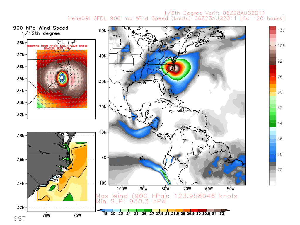
Re: ATL: IRENE - Models
06Z GFDL stats
HOUR: .0 LONG: -69.73 LAT: 20.08 MIN PRESS (hPa): 969.65 MAX SURF WIND (KNOTS): 79.61
HOUR: 6.0 LONG: -70.68 LAT: 20.23 MIN PRESS (hPa): 968.77 MAX SURF WIND (KNOTS): 81.78
HOUR: 12.0 LONG: -71.23 LAT: 20.45 MIN PRESS (hPa): 968.18 MAX SURF WIND (KNOTS): 77.93
HOUR: 18.0 LONG: -71.66 LAT: 20.72 MIN PRESS (hPa): 958.88 MAX SURF WIND (KNOTS): 88.51
HOUR: 24.0 LONG: -72.47 LAT: 21.26 MIN PRESS (hPa): 954.17 MAX SURF WIND (KNOTS): 98.53
HOUR: 30.0 LONG: -73.33 LAT: 21.91 MIN PRESS (hPa): 950.36 MAX SURF WIND (KNOTS):101.03
HOUR: 36.0 LONG: -74.11 LAT: 22.60 MIN PRESS (hPa): 947.86 MAX SURF WIND (KNOTS):107.04
HOUR: 42.0 LONG: -74.89 LAT: 23.33 MIN PRESS (hPa): 941.20 MAX SURF WIND (KNOTS):108.79
HOUR: 48.0 LONG: -75.80 LAT: 24.06 MIN PRESS (hPa): 938.21 MAX SURF WIND (KNOTS):109.97
HOUR: 54.0 LONG: -76.56 LAT: 24.89 MIN PRESS (hPa): 934.76 MAX SURF WIND (KNOTS):107.82
HOUR: 60.0 LONG: -76.97 LAT: 25.81 MIN PRESS (hPa): 931.99 MAX SURF WIND (KNOTS):120.86
HOUR: 66.0 LONG: -77.22 LAT: 26.76 MIN PRESS (hPa): 928.73 MAX SURF WIND (KNOTS):122.09
HOUR: 72.0 LONG: -77.58 LAT: 27.73 MIN PRESS (hPa): 927.89 MAX SURF WIND (KNOTS):125.27
HOUR: 78.0 LONG: -77.81 LAT: 28.65 MIN PRESS (hPa): 930.26 MAX SURF WIND (KNOTS):116.97
HOUR: 84.0 LONG: -77.78 LAT: 29.38 MIN PRESS (hPa): 929.65 MAX SURF WIND (KNOTS):119.52
HOUR: 90.0 LONG: -77.51 LAT: 30.20 MIN PRESS (hPa): 930.51 MAX SURF WIND (KNOTS):111.76
HOUR: 96.0 LONG: -77.42 LAT: 31.06 MIN PRESS (hPa): 932.40 MAX SURF WIND (KNOTS):110.45
HOUR:102.0 LONG: -77.23 LAT: 32.03 MIN PRESS (hPa): 931.88 MAX SURF WIND (KNOTS):103.61
HOUR:108.0 LONG: -77.01 LAT: 32.93 MIN PRESS (hPa): 927.70 MAX SURF WIND (KNOTS):111.34
HOUR:114.0 LONG: -76.64 LAT: 34.02 MIN PRESS (hPa): 926.11 MAX SURF WIND (KNOTS):106.99
HOUR:120.0 LONG: -76.43 LAT: 35.04 MIN PRESS (hPa): 930.00 MAX SURF WIND (KNOTS):104.95
HOUR:126.0 LONG: -76.01 LAT: 36.30 MIN PRESS (hPa): 935.09 MAX SURF WIND (KNOTS): 88.02

0 likes
-
Tyler Penland
- Tropical Depression

- Posts: 63
- Joined: Fri Aug 19, 2011 12:32 pm
- Location: Blowing Rock, NC
Re: ATL: IRENE - Models
jhpigott wrote:06z GDFL soon?
0 likes
****The above is NOT AN OFFICIAL FORECAST. I am in no way affiliated with the NWS or storm2k, and most likely don't share their opinion. Please refer to NWS/NHC products for official advisories/warnings/forecasts.****
But if you insist, trust me, I'm a physicist.
But if you insist, trust me, I'm a physicist.
Re: ATL: IRENE - Models
Looks like the 06z GFS, GDFL and HMRF are all a little further west than the 00z runs
0 likes
Who is online
Users browsing this forum: No registered users and 40 guests