#5057 Postby Dave » Tue Aug 23, 2011 10:55 pm
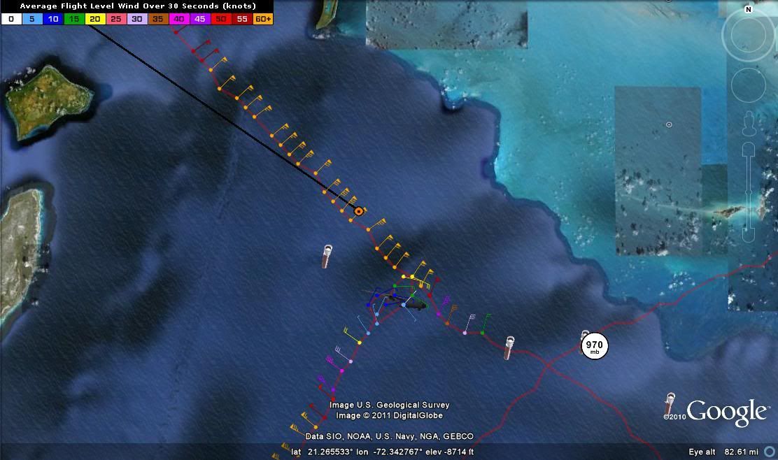
DECODED VDM OB 13
Product: Air Force Vortex Message (URNT12 KNHC)
Transmitted: 24th day of the month at 03:46Z
Aircraft: Air Force Aircraft (Last 3 digits of the tail number are 302)
Storm Number & Year: 09L in 2011
Storm Name: Irene (flight in the North Atlantic basin)
Mission Number: 11
Observation Number: 13
A. Time of Center Fix: 24th day of the month at 3:27:30Z
B. Center Fix Coordinates: 21°07'N 72°20'W (21.1167N 72.3333W)
B. Center Fix Location: 81 miles (130 km) to the WSW (253°) from Cockburn Town, Turks and Caicos Islands (GBR).
C. Minimum Height at Standard Level: 2,821m (9,255ft) at 700mb
D. Estimated (by SFMR or visually) Maximum Surface Wind: 64kts (~ 73.6mph)
E. Location of the Estimated Maximum Surface Wind: 15 nautical miles (17 statute miles) to the SW (217°) of center fix
F. Maximum Flight Level Wind Inbound: From 298° at 78kts (From the WNW at ~ 89.8mph)
G. Location of Maximum Flight Level Wind Inbound: 18 nautical miles (21 statute miles) to the SW (217°) of center fix
H. Minimum Sea Level Pressure: 969mb (28.61 inHg)
I. Maximum Flight Level Temp & Pressure Altitude Outside Eye: 13°C (55°F) at a pressure alt. of 3,046m (9,993ft)
J. Maximum Flight Level Temp & Pressure Altitude Inside Eye: 17°C (63°F) at a pressure alt. of 3,045m (9,990ft)
K. Dewpoint Temp (collected at same location as temp inside eye): 10°C (50°F)
K. Sea Surface Temp (collected at same location as temp inside eye): Not Available
L. Eye Character: Closed
M. Eye Shape & Diameter: Circular with a diameter of 30 nautical miles (35 statute miles)
N. Fix Determined By: Penetration, Radar, Wind, Pressure and Temperature
N. Fix Level: 700mb
O. Navigation Fix Accuracy: 0.02 nautical miles
O. Meteorological Accuracy: 1 nautical mile
Remarks Section:
Maximum Flight Level Wind: 92kts (~ 105.9mph) in the northwest quadrant at 1:25:30Z
Maximum Flight Level Wind Outbound: 91kts (~ 104.7mph) in the northeast quadrant at 3:34:00Z
0 likes
This post is NOT AN OFFICIAL FORECAST and should not be used as such. It is just the opinion of the poster and may or may not be backed by sound meteorological data. It is NOT endorsed by any professional institution including storm2k.org. For Official Information please refer to the NHC and NWS products.


