000
URNT15 KWBC 260008
NOAA2 2309A IRENE HDOB 26 20110825
235900 2829N 07835W 7530 02417 9952 +130 +129 051067 068 054 001 00
235930 2830N 07837W 7529 02421 9955 +130 +134 051065 066 054 002 00
000000 2832N 07839W 7528 02426 9960 +129 +134 048068 071 054 001 00
000030 2833N 07841W 7529 02429 9964 +130 +125 047064 066 053 000 00
000100 2835N 07842W 7530 02430 9970 +128 +125 048062 063 051 000 00
000130 2836N 07844W 7531 02433 9970 +132 +120 049058 059 049 000 00
000200 2837N 07846W 7529 02437 9973 +134 +104 046055 057 049 002 00
000230 2838N 07848W 7533 02434 9973 +137 +103 049054 056 /// /// 03
000300 2837N 07851W 7531 02440 9976 +136 +106 048058 060 /// /// 03
000330 2835N 07852W 7532 02437 9974 +137 +109 043058 058 050 001 00
000400 2833N 07853W 7529 02440 9972 +139 +109 041057 058 052 002 00
000430 2831N 07854W 7530 02438 9967 +139 +125 042056 057 052 005 00
000500 2828N 07855W 7529 02438 9966 +138 +131 041052 053 052 007 00
000530 2826N 07856W 7529 02438 9961 +142 +134 042051 053 050 007 00
000600 2824N 07857W 7530 02434 9958 +143 +132 041054 055 051 005 00
000630 2821N 07858W 7530 02433 9962 +140 +129 039052 053 051 004 00
000700 2819N 07859W 7529 02435 9960 +142 +127 035048 050 052 002 00
000730 2817N 07900W 7530 02435 9955 +148 +126 033048 048 052 001 00
000800 2814N 07902W 7530 02435 9958 +144 +131 028047 047 052 002 00
000830 2812N 07903W 7530 02435 9954 +149 +129 026046 047 053 000 00
http://www.nhc.noaa.gov/abouthdobs_2007.shtml
ATL: IRENE - Remnants - Discussion
Moderator: S2k Moderators
-
tolakram
- Admin

- Posts: 20185
- Age: 62
- Joined: Sun Aug 27, 2006 8:23 pm
- Location: Florence, KY (name is Mark)
Re: ATL: IRENE - Recon
0 likes
M a r k
- - - - -
Join us in chat: Storm2K Chatroom Invite. Android and IOS apps also available.
The posts in this forum are NOT official forecasts and should not be used as such. Posts are NOT endorsed by any professional institution or STORM2K.org. For official information and forecasts, please refer to NHC and NWS products.
-
Stephanie

- S2K Supporter

- Posts: 23843
- Age: 63
- Joined: Thu Feb 06, 2003 9:53 am
- Location: Glassboro, NJ
Re: ATL: IRENE - Hurricane - Discussion
PTPatrick wrote:Well managed to get my flight to Europe through Philly moved to Saturday from Sunday. Don't leave philly til Saturday evening at 6 though. So Miss Thing better not speed up. I based moving it on the premise that NHC has the cent around ATlantic city at 2pm Sunday. At 2 pm Saturday it should still be near the OBX. So hopefully this works. If not I may get to ride Irene out in the Philly airport also that the overall air travel Mahem will be worse Sunday, and Monday after it's passed the big hub cities of the north east.
I'm glad that you were able to get your flight changed. I hope that they didn't charge you an arm and a leg to do it.
0 likes
-
tolakram
- Admin
- Posts: 20185
- Age: 62
- Joined: Sun Aug 27, 2006 8:23 pm
- Location: Florence, KY (name is Mark)
Re: ATL: IRENE - Recon
0 likes
M a r k
- - - - -
Join us in chat: Storm2K Chatroom Invite. Android and IOS apps also available.
The posts in this forum are NOT official forecasts and should not be used as such. Posts are NOT endorsed by any professional institution or STORM2K.org. For official information and forecasts, please refer to NHC and NWS products.
- - - - -
Join us in chat: Storm2K Chatroom Invite. Android and IOS apps also available.
The posts in this forum are NOT official forecasts and should not be used as such. Posts are NOT endorsed by any professional institution or STORM2K.org. For official information and forecasts, please refer to NHC and NWS products.


Re: ATL: IRENE - Hurricane - Discussion
ROCK wrote:JtSmarts wrote:For Comparison's Sake
Hurricane Irene (5.PM Update): TS Winds: 290 Miles From Center/ H. Winds 80 Miles
Select Group of Former Storms At Landfall/Closet US Approach
Hurricane Earl (2010): TS Winds 205 Miles From Center/ H. Winds 70 Miles
Hurricane Ike (2008): TS Winds 275 Miles From Center/ H. Winds 120 Miles
Hurricane Gustav (2008): TS Winds 200 Miles From Center/ H. Winds 70 Miles
Hurricane Wilma (2005): TS Winds 230 Miles From Center/ H. Winds 90 Miles
Hurricane Katrina (2005): TS Winds 230 Miles From Center/ H. Winds 125 Miles
Hurricane Ivan (2004): TS Winds 290 Miles From Center/ H. Winds 105 Miles
Hurricane Frances (2004): TS Winds 200 Miles From Center/ H. Winds 85 Miles
Hurricane Isabel (2003): TS Winds 345 Miles From Center H. Winds 115 Miles
Hurricane Floyd (1999): TS Winds 260 Miles From Center/ H. Winds 115 Miles
Hurricane Bonnie (1998): TS Winds 230 Miles From Center/ H. Winds 115 Miles
IKE wins for just being a strong Cat2 at landfall....oh the memories...
Large hurricanes. Isabel, Ivan, Irene, and Ike are the largest. Interesting they are all "I" storms.
0 likes
-
SNOW_JOKE
- Tropical Depression

- Posts: 98
- Age: 42
- Joined: Mon Aug 01, 2011 7:47 pm
- Location: United Kingdom
Re: ATL: IRENE - Hurricane - Discussion
NBC Evening News noted that the HUGE construction cranes that are on jackup scaffolding building the new buildings at the WTC location are only designed to survive 65mph winds!!
If a couple of those things fall they could do a LOT of damage as they come down several hundred feet!! Maybe even knocking over the towers supporting them, which could then topple into neighboring buildings
If a couple of those things fall they could do a LOT of damage as they come down several hundred feet!! Maybe even knocking over the towers supporting them, which could then topple into neighboring buildings
0 likes
For Official Information please refer to the NHC and NWS Websites.
-
tolakram
- Admin
- Posts: 20185
- Age: 62
- Joined: Sun Aug 27, 2006 8:23 pm
- Location: Florence, KY (name is Mark)
Re: ATL: IRENE - Recon
000
URNT15 KWBC 260018
NOAA2 2309A IRENE HDOB 27 20110826
000900 2810N 07904W 7532 02432 9950 +153 +127 026048 049 051 001 00
000930 2807N 07905W 7533 02431 9952 +150 +127 025049 051 053 001 00
001000 2805N 07906W 7532 02433 9953 +149 +129 026050 053 053 000 00
001030 2803N 07907W 7531 02431 9950 +150 +124 022052 052 052 002 00
001100 2801N 07908W 7529 02432 9951 +148 +120 025053 054 051 000 00
001130 2758N 07909W 7529 02432 9953 +147 +117 020049 050 051 002 00
001200 2756N 07910W 7531 02431 9952 +150 +109 014054 056 051 003 00
001230 2753N 07911W 7532 02430 9950 +155 +098 007060 061 053 002 00
001300 2751N 07912W 7531 02434 9956 +149 +098 007062 063 053 003 00
001330 2749N 07913W 7531 02433 9958 +149 +098 007065 066 051 005 00
001400 2746N 07915W 7530 02435 9960 +147 +102 006065 066 050 005 00
001430 2744N 07916W 7530 02437 9962 +146 +105 006066 067 049 006 00
001500 2742N 07917W 7530 02437 9968 +140 +105 007070 072 049 005 00
001530 2739N 07918W 7530 02438 9973 +134 +116 009073 074 049 004 00
001600 2737N 07919W 7530 02439 9975 +134 +114 009071 073 048 004 03
001630 2734N 07919W 7531 02439 9975 +135 +113 004068 071 /// /// 03
001700 2732N 07917W 7529 02439 9974 +134 +109 003074 076 046 002 03
001730 2732N 07915W 7530 02434 9966 +137 +115 004066 071 045 001 00
001800 2732N 07913W 7530 02432 9960 +141 +112 003064 065 046 003 00
001830 2732N 07911W 7531 02427 9952 +146 +111 001063 066 047 001 00
http://www.nhc.noaa.gov/abouthdobs_2007.shtml
0 likes
M a r k
- - - - -
Join us in chat: Storm2K Chatroom Invite. Android and IOS apps also available.
The posts in this forum are NOT official forecasts and should not be used as such. Posts are NOT endorsed by any professional institution or STORM2K.org. For official information and forecasts, please refer to NHC and NWS products.
- - - - -
Join us in chat: Storm2K Chatroom Invite. Android and IOS apps also available.
The posts in this forum are NOT official forecasts and should not be used as such. Posts are NOT endorsed by any professional institution or STORM2K.org. For official information and forecasts, please refer to NHC and NWS products.

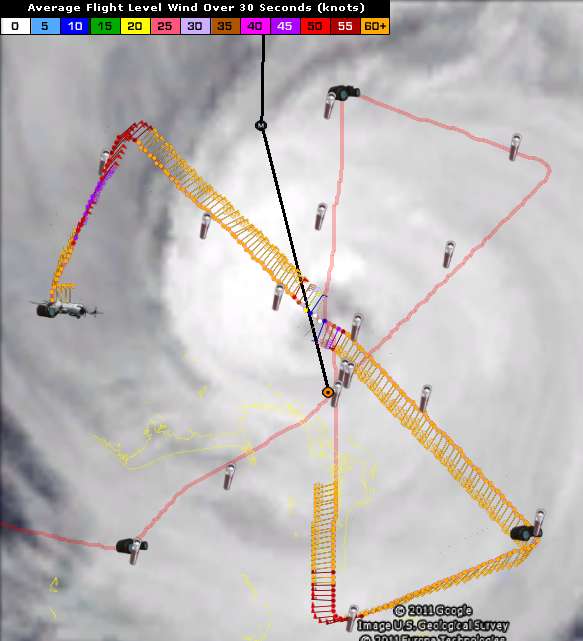
Hmm interesting radar, looks like its wobbled NW a little in the last hour, though to be fair its always tough to tell on radar the exact motion.
0 likes
Personal Forecast Disclaimer:
The posts in this forum are NOT official forecast and should not be used as such. They are just the opinion of the poster and may or may not be backed by sound meteorological data. They are NOT endorsed by any professional institution or storm2k.org. For official information, please refer to the NHC and NWS products
The posts in this forum are NOT official forecast and should not be used as such. They are just the opinion of the poster and may or may not be backed by sound meteorological data. They are NOT endorsed by any professional institution or storm2k.org. For official information, please refer to the NHC and NWS products
-
tolakram
- Admin
- Posts: 20185
- Age: 62
- Joined: Sun Aug 27, 2006 8:23 pm
- Location: Florence, KY (name is Mark)
Re: ATL: IRENE - Recon
0 likes
M a r k
- - - - -
Join us in chat: Storm2K Chatroom Invite. Android and IOS apps also available.
The posts in this forum are NOT official forecasts and should not be used as such. Posts are NOT endorsed by any professional institution or STORM2K.org. For official information and forecasts, please refer to NHC and NWS products.
- - - - -
Join us in chat: Storm2K Chatroom Invite. Android and IOS apps also available.
The posts in this forum are NOT official forecasts and should not be used as such. Posts are NOT endorsed by any professional institution or STORM2K.org. For official information and forecasts, please refer to NHC and NWS products.
Re:
KatDaddy wrote:The size of Irene is amazing. She would fill most of the GOM. I hope everyone is heeding the evacs and getting off the Outer Banks now. It will look like Bolivar after IKE.
They need to evacuate now. Complacency kills! Just look at Ike or Katrina.
0 likes
Re: ATL: IRENE - Hurricane - Discussion
great loop
NOTICE how she has almost slowed to a STALL since 630pm what's goin on with that
edit: remove IMG tags when quoting please -Mark
0 likes

Re: ATL: IRENE - Hurricane - Discussion
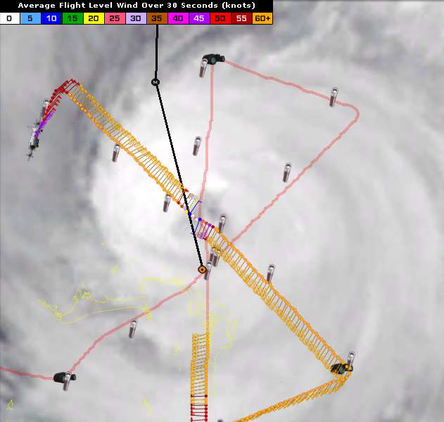
cpdaman wrote:tolakram wrote:Radar Loop
great loop
NOTICE how she has almost slowed to a STALL since 630pm what's goin on with that
scary that it is just sitting there in an ideal environment just kind of filling up with energy before the trip north...
0 likes
Just like Jon Snow..."I know nothing" except what I know, and most of what I know is gathered by the fine people of the NHC
-
Meteorcane

- Category 2

- Posts: 559
- Joined: Thu Jul 21, 2011 6:49 am
- Location: North Platte Nebraska
Re: ATL: IRENE - Hurricane - Discussion
hurricaneCW wrote:
IKE really stunned me, only a Cat 2 at landfall and it delivered a massive surge, Katrina hit as a 3 but pretty much brought Cat 5 surge, it's all about the storm's size and built up energy that gets released even if the storm is not technically very strong. I'm not sure how large Ike was though compared to how big Irene is now.
I have been through Ike and it was scary! It was rainy and windy for hours and hours. Scary times!
0 likes
-
Aja

- Tropical Low

- Posts: 42
- Age: 62
- Joined: Wed Aug 24, 2011 1:21 pm
- Location: Charleston, SC
- Contact:
After watching Ft. Lauderdale & Miami live beach cams all day, I noticed the wave and wind impact distance from Irene was not that bad. Ga. & SC coasts are further to the west than those two Florida points. Should the impacts expected be the same as she passes or should there be any real concern since we are west and not north or east of Irene?
In all the hurricanes I have been through or followed, Irene just seems too different.
______
Just my opinion,,, For official information, please refer to the NHC and NWS products
In all the hurricanes I have been through or followed, Irene just seems too different.
______
Just my opinion,,, For official information, please refer to the NHC and NWS products
Last edited by Aja on Thu Aug 25, 2011 7:45 pm, edited 1 time in total.
0 likes
-
Scorpion
Re:
Aja wrote:After watching Ft. Lauderdale & Miami live beach cams all day, I noticed the wave and wind impact distance from Irene was not that bad. Ga. & SC coasts are further to the west than those two Florida points. Should the impacts expected be the same as she passes or should there be any real concern since we are west and not north or east of Irene?
In all the hurricanes I have been through or followed, Irene just seems to different.
The Bahamas would help to break up the wave impacts.
0 likes
-
tolakram
- Admin
- Posts: 20185
- Age: 62
- Joined: Sun Aug 27, 2006 8:23 pm
- Location: Florence, KY (name is Mark)
Re: ATL: IRENE - Recon
000
URNT15 KWBC 260028
NOAA2 2309A IRENE HDOB 28 20110826
001900 2732N 07908W 7530 02426 9950 +142 +123 357057 061 047 003 00
001930 2732N 07906W 7530 02424 9950 +139 +137 358049 050 050 007 00
002000 2732N 07904W 7530 02419 9942 +142 +140 357052 053 052 004 00
002030 2732N 07902W 7532 02413 9932 +148 +139 357053 053 053 001 00
002100 2732N 07859W 7531 02410 9924 +152 +131 353053 053 053 001 00
002130 2732N 07857W 7530 02407 9918 +155 +122 352055 056 053 001 00
002200 2732N 07855W 7530 02403 9911 +158 +122 354054 054 054 001 00
002230 2732N 07852W 7529 02400 9907 +158 +121 000055 056 055 001 00
002300 2732N 07850W 7532 02393 9900 +161 +117 358057 057 055 002 00
002330 2732N 07848W 7531 02389 9895 +162 +117 359058 059 056 000 00
002400 2732N 07846W 7531 02385 9894 +158 +119 001061 062 056 001 00
002430 2732N 07843W 7530 02383 9894 +152 +124 004064 064 055 003 00
002500 2732N 07841W 7534 02375 9885 +157 +125 002063 064 056 000 00
002530 2732N 07839W 7529 02374 9878 +158 +133 003062 064 057 001 00
002600 2732N 07837W 7533 02365 9874 +156 +136 003064 065 056 002 00
002630 2732N 07835W 7533 02359 9863 +159 +137 003066 067 057 000 00
002700 2732N 07833W 7531 02356 9863 +152 +140 003066 067 058 001 00
002730 2732N 07830W 7531 02348 9853 +155 +140 002063 064 058 002 00
002800 2732N 07828W 7530 02344 9842 +160 +140 002064 066 059 001 00
002830 2732N 07826W 7528 02338 9837 +157 +145 004064 064 058 003 00
http://www.nhc.noaa.gov/abouthdobs_2007.shtml
0 likes
M a r k
- - - - -
Join us in chat: Storm2K Chatroom Invite. Android and IOS apps also available.
The posts in this forum are NOT official forecasts and should not be used as such. Posts are NOT endorsed by any professional institution or STORM2K.org. For official information and forecasts, please refer to NHC and NWS products.
- - - - -
Join us in chat: Storm2K Chatroom Invite. Android and IOS apps also available.
The posts in this forum are NOT official forecasts and should not be used as such. Posts are NOT endorsed by any professional institution or STORM2K.org. For official information and forecasts, please refer to NHC and NWS products.
-
seussianagenda
- Tropical Low
- Posts: 33
- Joined: Fri Sep 05, 2008 4:54 pm
Re: ATL: IRENE - Hurricane - Discussion
A member of the Norfolk City Council just told me he recommended mandatory evacs for Norfolk.
0 likes
-
Ivanhater

- Storm2k Moderator

- Posts: 11221
- Age: 39
- Joined: Fri Jul 01, 2005 8:25 am
- Location: Pensacola
Re: ATL: IRENE - Hurricane - Discussion
PLEASE REMOVE IMG TAGS WHEN QUOTING ANOTHER POST WITH AN IMAGE
0 likes
Michael
Who is online
Users browsing this forum: No registered users and 16 guests