ATL: IRENE - Remnants - Discussion
Moderator: S2k Moderators
-
Scorpion

Re: ATL: IRENE - Hurricane - Discussion
Regarding waves, in general east coast of Florida has very deep water not far offshore, so there isn't the surge potential like there is on the northern Gulf coast and anyplace else with a long shallow shelf.
Andrew caused a max of about 17 foot surge along a small section of Biscayne Bay, and that was a Cat 5 of course.
Andrew caused a max of about 17 foot surge along a small section of Biscayne Bay, and that was a Cat 5 of course.
0 likes
-
tolakram
- Admin

- Posts: 20185
- Age: 62
- Joined: Sun Aug 27, 2006 8:23 pm
- Location: Florence, KY (name is Mark)
Re: ATL: IRENE - Recon
0 likes
M a r k
- - - - -
Join us in chat: Storm2K Chatroom Invite. Android and IOS apps also available.
The posts in this forum are NOT official forecasts and should not be used as such. Posts are NOT endorsed by any professional institution or STORM2K.org. For official information and forecasts, please refer to NHC and NWS products.
-
SunnyThoughts
- Category 5

- Posts: 2263
- Joined: Wed Jul 09, 2003 12:42 pm
- Location: Pensacola, Florida
-
tolakram
- Admin
- Posts: 20185
- Age: 62
- Joined: Sun Aug 27, 2006 8:23 pm
- Location: Florence, KY (name is Mark)
Re: ATL: IRENE - Recon
000
URNT15 KWBC 260038
NOAA2 2309A IRENE HDOB 29 20110826
002900 2732N 07824W 7529 02331 9832 +152 +151 007067 070 059 005 00
002930 2732N 07822W 7537 02313 9817 +158 +155 001057 059 058 006 00
003000 2733N 07820W 7532 02313 9807 +161 +158 357056 057 060 006 00
003030 2733N 07818W 7531 02308 9799 +161 +161 357060 061 062 007 00
003100 2733N 07815W 7531 02300 9792 +161 +161 355061 061 062 004 00
003130 2733N 07813W 7529 02294 9782 +162 +159 355063 064 065 001 03
003200 2733N 07811W 7531 02281 9770 +163 +159 353061 063 064 002 00
003230 2734N 07809W 7531 02270 9758 +163 +165 351057 059 065 003 00
003300 2734N 07806W 7529 02266 9751 +161 +163 349058 058 061 003 00
003330 2734N 07804W 7530 02255 9739 +166 +156 351060 062 060 004 00
003400 2734N 07802W 7529 02250 9726 +174 +146 355062 063 058 003 00
003430 2734N 07759W 7530 02240 9713 +180 +133 358062 063 053 001 00
003500 2734N 07757W 7531 02228 9699 +184 +130 354064 065 052 001 00
003530 2734N 07755W 7533 02215 9688 +184 +121 351064 065 052 000 00
003600 2734N 07753W 7532 02206 9676 +182 +136 347065 066 054 001 00
003630 2734N 07750W 7528 02199 9659 +186 +151 348065 065 053 002 00
003700 2735N 07748W 7531 02185 9645 +189 +145 349066 067 054 001 00
003730 2735N 07746W 7530 02170 9627 +188 +165 353067 068 053 004 00
003800 2735N 07743W 7531 02154 9611 +190 +154 352070 071 055 001 00
003830 2735N 07741W 7531 02136 9591 +193 +143 351074 075 056 000 00
0 likes
M a r k
- - - - -
Join us in chat: Storm2K Chatroom Invite. Android and IOS apps also available.
The posts in this forum are NOT official forecasts and should not be used as such. Posts are NOT endorsed by any professional institution or STORM2K.org. For official information and forecasts, please refer to NHC and NWS products.
- - - - -
Join us in chat: Storm2K Chatroom Invite. Android and IOS apps also available.
The posts in this forum are NOT official forecasts and should not be used as such. Posts are NOT endorsed by any professional institution or STORM2K.org. For official information and forecasts, please refer to NHC and NWS products.

Re:
SunnyThoughts wrote:Was just watching the weather channel. Just caught it in passing so not sure who it was speaking about IRene, but he said something was going on with the eye and it looked like to him that some dry air had perhaps gotten into the core and that if thats the case, it's a good thing.
That was Brian Norcross...he is correct that the west side is being flattened by dry air, which has occurred most of the day. He also noted the eye was filling in...it cleared out again in the last couple of frames, but it looks a little more ragged than it did a couple of hours ago...
0 likes

Re: ATL: IRENE - Hurricane - Discussion
How crazy...
From nbcnewyork.com.
MTA Chairman Jay Walder said that if Hurricane Irene continues on the path that is forecast, the entire system would be shut down by Saturday afternoon. Bloomberg warned there would likely be no mass transit until midday Monday, at the earliest.
From nbcnewyork.com.
0 likes
-
tolakram
- Admin
- Posts: 20185
- Age: 62
- Joined: Sun Aug 27, 2006 8:23 pm
- Location: Florence, KY (name is Mark)
Re: ATL: IRENE - Recon
0 likes
M a r k
- - - - -
Join us in chat: Storm2K Chatroom Invite. Android and IOS apps also available.
The posts in this forum are NOT official forecasts and should not be used as such. Posts are NOT endorsed by any professional institution or STORM2K.org. For official information and forecasts, please refer to NHC and NWS products.
- - - - -
Join us in chat: Storm2K Chatroom Invite. Android and IOS apps also available.
The posts in this forum are NOT official forecasts and should not be used as such. Posts are NOT endorsed by any professional institution or STORM2K.org. For official information and forecasts, please refer to NHC and NWS products.
-
CrazyC83
- Professional-Met

- Posts: 34315
- Joined: Tue Mar 07, 2006 11:57 pm
- Location: Deep South, for the first time!
Re: ATL: IRENE - Hurricane - Discussion
tina25 wrote:How crazy...MTA Chairman Jay Walder said that if Hurricane Irene continues on the path that is forecast, the entire system would be shut down by Saturday afternoon. Bloomberg warned there would likely be no mass transit until midday Monday, at the earliest.
From nbcnewyork.com.
Saturday afternoon is a bit early IMO, but it would be needed at least late Saturday evening. Subways may not be on line for many days.
0 likes
-
tolakram
- Admin
- Posts: 20185
- Age: 62
- Joined: Sun Aug 27, 2006 8:23 pm
- Location: Florence, KY (name is Mark)
Re: ATL: IRENE - Hurricane - Discussion
For those of you wanting to post local new items please take a look at the stickied posts at the top of this forum.
Irene - Mid-Atlantic Prep and Impact viewtopic.php?f=59&t=111610
Irene - Northeast US Prep and Impact viewtopic.php?f=59&t=111608
Thanks.
Irene - Mid-Atlantic Prep and Impact viewtopic.php?f=59&t=111610
Irene - Northeast US Prep and Impact viewtopic.php?f=59&t=111608
Thanks.
0 likes
M a r k
- - - - -
Join us in chat: Storm2K Chatroom Invite. Android and IOS apps also available.
The posts in this forum are NOT official forecasts and should not be used as such. Posts are NOT endorsed by any professional institution or STORM2K.org. For official information and forecasts, please refer to NHC and NWS products.
- - - - -
Join us in chat: Storm2K Chatroom Invite. Android and IOS apps also available.
The posts in this forum are NOT official forecasts and should not be used as such. Posts are NOT endorsed by any professional institution or STORM2K.org. For official information and forecasts, please refer to NHC and NWS products.
-
tolakram
- Admin
- Posts: 20185
- Age: 62
- Joined: Sun Aug 27, 2006 8:23 pm
- Location: Florence, KY (name is Mark)
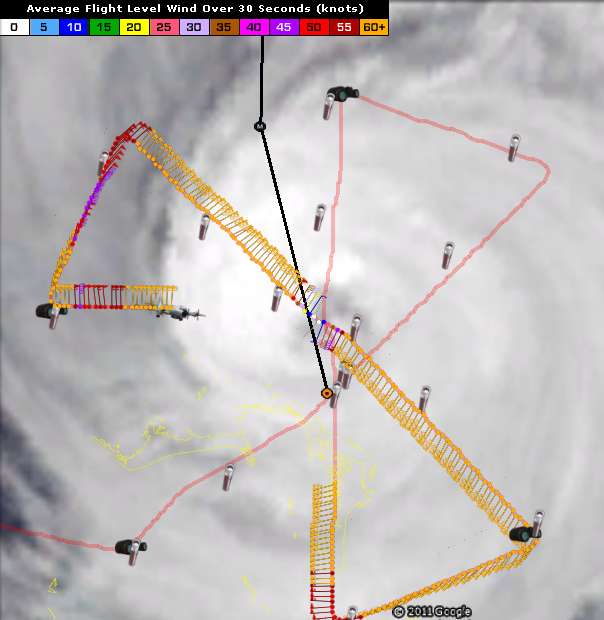
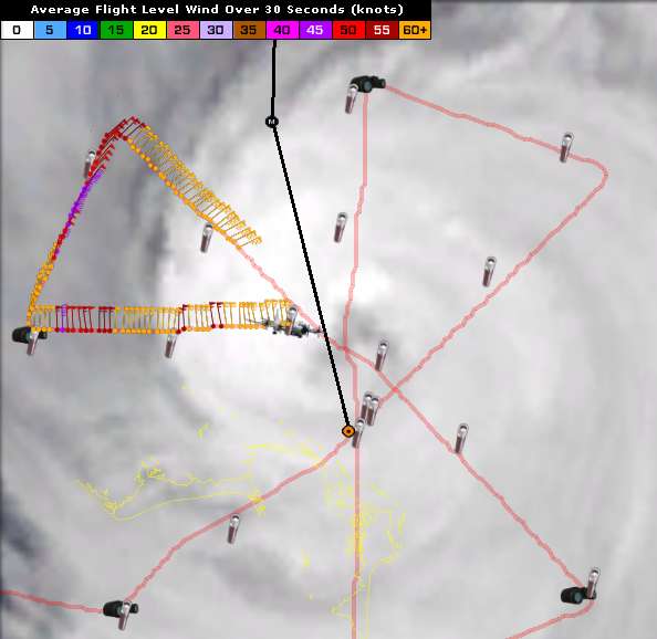
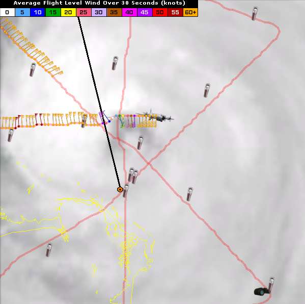
Re: ATL: IRENE - Recon
000
URNT15 KWBC 260048
NOAA2 2309A IRENE HDOB 30 20110826
003900 2734N 07739W 7531 02116 9565 +199 +139 351075 076 059 003 00
003930 2734N 07736W 7531 02091 9532 +205 +158 350078 080 062 004 00
004000 2734N 07734W 7529 02066 9507 +200 +172 348076 079 060 005 00
004030 2734N 07732W 7529 02045 9485 +193 +188 345065 070 054 004 00
004100 2735N 07729W 7531 02021 9463 +197 +181 340048 057 040 001 03
004130 2735N 07727W 7530 02009 9451 +195 +181 332029 035 032 000 00
004200 2736N 07725W 7526 02007 9437 +203 +177 324014 019 024 000 00
004230 2738N 07723W 7538 01988 9438 +197 +178 274001 006 021 000 00
004300 2739N 07721W 7539 01986 9443 +189 +181 138008 009 018 001 00
004330 2739N 07719W 7511 02019 9444 +189 +178 162015 019 024 001 00
004400 2739N 07717W 7516 02019 9449 +191 +167 172023 026 024 001 00
004430 2739N 07714W 7518 02021 9450 +196 +156 173027 029 030 000 00
004500 2739N 07712W 7513 02033 9458 +193 +165 172035 038 031 000 00
004530 2739N 07710W 7520 02030 9467 +189 +172 177045 051 047 005 00
004600 2739N 07707W 7531 02029 9479 +187 +182 178062 070 061 023 03
004630 2739N 07705W 7527 02052 9498 +182 //// 180081 086 062 044 05
004700 2739N 07703W 7504 02101 9527 +178 //// 179097 100 078 027 01
004730 2739N 07701W 7524 02104 9558 +175 +178 179097 098 081 018 00
004800 2739N 07659W 7546 02100 9585 +172 //// 181092 093 081 017 01
004830 2739N 07657W 7514 02160 9606 +172 //// 181094 096 081 023 01
http://www.nhc.noaa.gov/abouthdobs_2007.shtml
0 likes
M a r k
- - - - -
Join us in chat: Storm2K Chatroom Invite. Android and IOS apps also available.
The posts in this forum are NOT official forecasts and should not be used as such. Posts are NOT endorsed by any professional institution or STORM2K.org. For official information and forecasts, please refer to NHC and NWS products.
- - - - -
Join us in chat: Storm2K Chatroom Invite. Android and IOS apps also available.
The posts in this forum are NOT official forecasts and should not be used as such. Posts are NOT endorsed by any professional institution or STORM2K.org. For official information and forecasts, please refer to NHC and NWS products.
-
wxman57

- Moderator-Pro Met

- Posts: 23174
- Age: 68
- Joined: Sat Jun 21, 2003 8:06 pm
- Location: Houston, TX (southwest)
Re:
CrazyC83 wrote:Question: my elevation is 198 feet and the river a block away is at 194 feet. I have a small creek behind me with a hill on the other side. What should I be preparing for? Models suggest about a 20% chance of getting into the rain, but it would be heavy.
You near Ingleside, Canada? You'll be on the western edge of the precip shield. Could get a few inches of rain on Monday.
0 likes

Re: ATL: IRENE - Hurricane - Discussion
Ptarmigan wrote:ROCK wrote:JtSmarts wrote:For Comparison's Sake
Hurricane Irene (5.PM Update): TS Winds: 290 Miles From Center/ H. Winds 80 Miles
Select Group of Former Storms At Landfall/Closet US Approach
Hurricane Earl (2010): TS Winds 205 Miles From Center/ H. Winds 70 Miles
Hurricane Ike (2008): TS Winds 275 Miles From Center/ H. Winds 120 Miles
Hurricane Gustav (2008): TS Winds 200 Miles From Center/ H. Winds 70 Miles
Hurricane Wilma (2005): TS Winds 230 Miles From Center/ H. Winds 90 Miles
Hurricane Katrina (2005): TS Winds 230 Miles From Center/ H. Winds 125 Miles
Hurricane Ivan (2004): TS Winds 290 Miles From Center/ H. Winds 105 Miles
Hurricane Frances (2004): TS Winds 200 Miles From Center/ H. Winds 85 Miles
Hurricane Isabel (2003): TS Winds 345 Miles From Center H. Winds 115 Miles
Hurricane Floyd (1999): TS Winds 260 Miles From Center/ H. Winds 115 Miles
Hurricane Bonnie (1998): TS Winds 230 Miles From Center/ H. Winds 115 Miles
IKE wins for just being a strong Cat2 at landfall....oh the memories...
Large hurricanes. Isabel, Ivan, Irene, and Ike are the largest. Interesting they are all "I" storms.
And Igor is the largest on record in the Atlantic basin!
0 likes

Re: ATL: IRENE - Hurricane - Discussion
Green blips on Funktop are fast firing small eyewall hot towers.
She is continuing to ramp.
http://www.ssd.noaa.gov/goes/flt/t2/flash-ft.html
She is continuing to ramp.
http://www.ssd.noaa.gov/goes/flt/t2/flash-ft.html
0 likes
-
tolakram
- Admin
- Posts: 20185
- Age: 62
- Joined: Sun Aug 27, 2006 8:23 pm
- Location: Florence, KY (name is Mark)
Re: ATL: IRENE - Recon
0 likes
M a r k
- - - - -
Join us in chat: Storm2K Chatroom Invite. Android and IOS apps also available.
The posts in this forum are NOT official forecasts and should not be used as such. Posts are NOT endorsed by any professional institution or STORM2K.org. For official information and forecasts, please refer to NHC and NWS products.
- - - - -
Join us in chat: Storm2K Chatroom Invite. Android and IOS apps also available.
The posts in this forum are NOT official forecasts and should not be used as such. Posts are NOT endorsed by any professional institution or STORM2K.org. For official information and forecasts, please refer to NHC and NWS products.
-
CrazyC83
- Professional-Met
- Posts: 34315
- Joined: Tue Mar 07, 2006 11:57 pm
- Location: Deep South, for the first time!
Re: Re:
wxman57 wrote:CrazyC83 wrote:Question: my elevation is 198 feet and the river a block away is at 194 feet. I have a small creek behind me with a hill on the other side. What should I be preparing for? Models suggest about a 20% chance of getting into the rain, but it would be heavy.
You near Ingleside, Canada? You'll be on the western edge of the precip shield. Could get a few inches of rain on Monday.
Near Ottawa. I cannot post real preps or local info since no thread exists, although the Northeast thread may be suitable.
Last edited by CrazyC83 on Thu Aug 25, 2011 8:13 pm, edited 1 time in total.
0 likes
-
Jevo

- S2K Supporter

- Posts: 1729
- Age: 47
- Joined: Tue Aug 03, 2004 8:45 pm
- Location: The Flemish Cap
- Contact:
Not a symetrical as this time last night, but I believe this was expected... before a slight increase

Uploaded with ImageShack.us

Uploaded with ImageShack.us
0 likes
Disclaimer: 50% of the time I have no clue of what I am talking about. Chances are I am taking a less than educated guess that sounds good because 10 years ago I stole Mike Watkins book 'The Hurricane and its Impact'. For official information please direct yourself to the NHC and their cadre of weather geniuses.
-
tolakram
- Admin
- Posts: 20185
- Age: 62
- Joined: Sun Aug 27, 2006 8:23 pm
- Location: Florence, KY (name is Mark)
Re: ATL: IRENE - Hurricane - Discussion
live IR loop: http://wwwghcc.msfc.nasa.gov/cgi-bin/ge ... =spect.pal
0 likes
M a r k
- - - - -
Join us in chat: Storm2K Chatroom Invite. Android and IOS apps also available.
The posts in this forum are NOT official forecasts and should not be used as such. Posts are NOT endorsed by any professional institution or STORM2K.org. For official information and forecasts, please refer to NHC and NWS products.
- - - - -
Join us in chat: Storm2K Chatroom Invite. Android and IOS apps also available.
The posts in this forum are NOT official forecasts and should not be used as such. Posts are NOT endorsed by any professional institution or STORM2K.org. For official information and forecasts, please refer to NHC and NWS products.
Who is online
Users browsing this forum: No registered users and 9 guests