Gulf Homebrew? (Is invest 93L)

This is the general tropical discussion area. Anyone can take their shot at predicting a storms path.

Moderator: S2k Moderators

Forum rules

The posts in this forum are NOT official forecasts and should not be used as such. They are just the opinion of the poster and may or may not be backed by sound meteorological data. They are NOT endorsed by any professional institution or STORM2K. For official information, please refer to products from the National Hurricane Center and National Weather Service.

Help Support Storm2K
Message
Author
User avatar
Ivanhater
Storm2k Moderator
Storm2k Moderator
Posts: 11161
Age: 38
Joined: Fri Jul 01, 2005 8:25 am
Location: Pensacola

Gulf Homebrew? (Is invest 93L)

#1 Postby Ivanhater » Sat Aug 27, 2011 11:52 am

The GFS has been advertising a system developing in the BOC and the 00z Euro jumps on board sending the system into the North central Gulf coast

00z GFS

Image

Uploaded with ImageShack.us

00z Euro

Image

Uploaded with ImageShack.us

FIMY model

Image
Last edited by cycloneye on Wed Aug 31, 2011 1:18 pm, edited 2 times in total.
Reason: To add invest 93L
0 likes   
Michael

User avatar
Rgv20
S2K Supporter
S2K Supporter
Posts: 2466
Age: 38
Joined: Wed Jan 05, 2011 5:42 pm
Location: Edinburg/McAllen Tx

#2 Postby Rgv20 » Sat Aug 27, 2011 12:19 pm

Looks like the GOM is going to get interesting as we head until Labor Day. 0zECMWF operational has a TC in ten day moving until Mobile and the 0zECMWF Ensembles show a lot of possibilities with regards to track of this potential TC.

This is the 0zECMWF Ensemble Forecast Map for 10 days. The dark shading shows that some of the ensembles favor a Western Gulf Threat.
Image
0 likes   
The following post is NOT an official forecast and should not be used as such. It is just the opinion of the poster and may or may not be backed by sound meteorological data. It is NOT endorsed by any professional institution including storm2k.org For Official Information please refer to the NHC and NWS products.

User avatar
LaBreeze
Category 5
Category 5
Posts: 1497
Joined: Thu Sep 04, 2003 1:57 pm
Location: SW Louisiana

Re:

#3 Postby LaBreeze » Sat Aug 27, 2011 12:40 pm

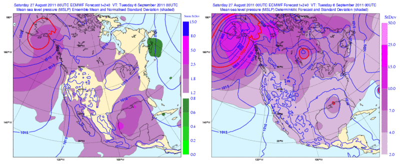
Rgv20 wrote:Looks like the GOM is going to get interesting as we head until Labor Day. 0zECMWF operational has a TC in ten day moving until Mobile and the 0zECMWF Ensembles show a lot of possibilities with regards to track of this potential TC.

This is the 0zECMWF Ensemble Forecast Map for 10 days. The dark shading shows that some of the ensembles favor a Western Gulf Threat.
Image


Western GOM (TX and LA) need the rainfall desperately. Something to cool down those temps. also.
0 likes   

User avatar
KatDaddy
Category 5
Category 5
Posts: 2815
Joined: Mon Oct 21, 2002 6:23 pm
Location: League City, Texas

#4 Postby KatDaddy » Sat Aug 27, 2011 12:48 pm

New Orleans and Corpus Christi AFDs mentioned potential lowering of pressures in the GOM.

New Orleans AFD:

FRI AND INTO NEXT WEEKEND...THE MDLS ARE STRUGGLING IN HOW THEY
HANDLE THE RIDGE AND A POSSIBLE WEAK UPPER LOW OVER TX/WRN GULF. THE
ECMWF AND CANADIAN ARE A LITTLE FURTHER NORTH WITH THE RIDGE AND
STRONGER WITH THE UPPER LOW AND THEN PUSH IT EAST INTO THE GULF.
THIS COULD LEAD TO A WEAK SFC LOW TO DEVELOP IN THE GULF AND COULD
BARE WATCHING. ON THE OTHER HAND THE GFS IS WEAKER WITH THE UPPER
LOW AND THEN RETROGRADES THE MID LVL RIDGE FASTER AND THUS NOT
LEADING TO ANY SFC LOW. LUCKILY THIS IS AT THE BACK END OF THE FCST
SO WE HAVE TIME TO WATCH AND IF ANYTHING DOES DEVELOP IT WOULD BE
NEXT WEEKEND.

Corpus Christi AFD:

AT THIS TIME...WILL WAIT AND SEE WHAT FUTURE MODEL RUNS HAVE IN STORE
FOR SOUTH TEXAS IN THE EXTENDED. ALSO...THESE TWO MODELS TRY TO
DEVELOP SOMETHING TROPICAL IN THE GULF OF MEXICO BEYOND DAY 7 (BOTH
DIFFER ON TIMING AND LOCATION).
0 likes   
The following post is NOT an official forecast and should not be used as such. It is just the opinion of the poster and may or may not be backed by sound meteorological data. It is NOT endorsed by any professional institution including storm2k.org For Official Information please refer to the NHC and NWS products.

User avatar
LaBreeze
Category 5
Category 5
Posts: 1497
Joined: Thu Sep 04, 2003 1:57 pm
Location: SW Louisiana

Re:

#5 Postby LaBreeze » Sat Aug 27, 2011 1:36 pm

KatDaddy wrote:New Orleans and Corpus Christi AFDs mentioned potential lowering of pressures in the GOM.

New Orleans AFD:

FRI AND INTO NEXT WEEKEND...THE MDLS ARE STRUGGLING IN HOW THEY
HANDLE THE RIDGE AND A POSSIBLE WEAK UPPER LOW OVER TX/WRN GULF. THE
ECMWF AND CANADIAN ARE A LITTLE FURTHER NORTH WITH THE RIDGE AND
STRONGER WITH THE UPPER LOW AND THEN PUSH IT EAST INTO THE GULF.
THIS COULD LEAD TO A WEAK SFC LOW TO DEVELOP IN THE GULF AND COULD
BARE WATCHING. ON THE OTHER HAND THE GFS IS WEAKER WITH THE UPPER
LOW AND THEN RETROGRADES THE MID LVL RIDGE FASTER AND THUS NOT
LEADING TO ANY SFC LOW. LUCKILY THIS IS AT THE BACK END OF THE FCST
SO WE HAVE TIME TO WATCH AND IF ANYTHING DOES DEVELOP IT WOULD BE
NEXT WEEKEND.

Corpus Christi AFD:

AT THIS TIME...WILL WAIT AND SEE WHAT FUTURE MODEL RUNS HAVE IN STORE
FOR SOUTH TEXAS IN THE EXTENDED. ALSO...THESE TWO MODELS TRY TO
DEVELOP SOMETHING TROPICAL IN THE GULF OF MEXICO BEYOND DAY 7 (BOTH
DIFFER ON TIMING AND LOCATION).


KatDaddy, do you think we may get some rainfall or some sort of action next weekend here along the NW and W GOM?
0 likes   

User avatar
ROCK
Category 5
Category 5
Posts: 9484
Age: 54
Joined: Tue Aug 17, 2004 7:30 am
Location: Kemah, Texas

Re: Gulf Homebrew?

#6 Postby ROCK » Sat Aug 27, 2011 2:06 pm

looks fairly weak and broad...track up into the N-E GOM so far from guidance....thought the CMC developes this late and sends it into STex.....might squeeze out some rain for us....
0 likes   

User avatar
wxman57
Moderator-Pro Met
Moderator-Pro Met
Posts: 22979
Age: 67
Joined: Sat Jun 21, 2003 8:06 pm
Location: Houston, TX (southwest)

Re: Gulf Homebrew?

#7 Postby wxman57 » Sat Aug 27, 2011 2:20 pm

Euro backing off now - more like the GFS. Significant pattern change that COULD bring some decent rain to Texas Labor Day weekend and beyond.
0 likes   

User avatar
Tireman4
S2K Supporter
S2K Supporter
Posts: 5853
Age: 59
Joined: Fri Jun 30, 2006 1:08 pm
Location: Humble, Texas
Contact:

Re: Gulf Homebrew?

#8 Postby Tireman4 » Sat Aug 27, 2011 2:23 pm

wxman57 wrote:Euro backing off now - more like the GFS. Significant pattern change that COULD bring some decent rain to Texas Labor Day weekend and beyond.


Define decent young sir. More than an inch?
0 likes   

WeatherEmperor
S2K Supporter
S2K Supporter
Posts: 4806
Age: 41
Joined: Thu Sep 04, 2003 2:54 pm
Location: South Florida

Re: Gulf Homebrew?

#9 Postby WeatherEmperor » Sat Aug 27, 2011 2:28 pm

wxman57 wrote:Euro backing off now - more like the GFS. Significant pattern change that COULD bring some decent rain to Texas Labor Day weekend and beyond.


When you say pattern change, do you mean more cold fronts digging down? If so, could they also make their way toward the east coast?
0 likes   

underthwx
Category 5
Category 5
Posts: 2360
Joined: Sat Jul 30, 2011 2:14 pm
Location: Brazoria County Texas

Re: Gulf Homebrew?

#10 Postby underthwx » Sat Aug 27, 2011 3:15 pm

.LONG TERM.../MONDAY THROUGH SATURDAY/...A FAIRLY SIGNIFICANT CHANGE TO
THE WEATHER PATTERN ACROSS DEEP SOUTH TEXAS IS EXPECTED BY MID WEEK.
THE LARGE DOME OF HIGH PRESSURE WHICH HAS BEEN CENTERED OVER TEXAS
AND THE SW UNITED STATES WILL MIGRATE TO THE SOUTHEAST US BY WED. THIS
WILL PROVIDE ONSHORE FLOW AND AN INCREASE IN MOISTURE IN THE MID
LEVELS OF THE ATMOSPHERE. MINOR DISTURBANCES WILL EMBEDDED IN THE
UPPER LEVEL FLOW AROUND THIS HIGH PRESSURE SYSTEM WILL ADD SOME LIFT
AND INSTABILITY. FINALLY...SURFACE LOW PRESSURE WILL DEVELOP AND
PERSIST ACROSS THE SOUTHWEST AREAS OF THE GULF OF MEXICO WHICH WILL
ADVECT AMPLE LOW LEVEL MOISTURE INTO THE VALLEY. THE RESULT WILL BE
INCREASING CHANCES OF SHOWERS AND EMBEDDED THUNDERSTORMS...AN
INCREASE IN OVERALL CLOUDINESS...AND TEMPS MODERATING TO MORE
SEASONAL NORMS. UNTIL THEN...VERY WARM AND ABOVE SEASONAL NORMAL
TEMPS ARE ANTICIPATED MONDAY AND TUESDAY AS VERY DRY AIR IN THE MID
AND UPPER LEVELS PERSIST. SOME OF THAT DRIER AIR WILL ALSO TRANSEND
TO THE SURFACE. AS A RESULT...TEMPS WILL WARM AND COOL MORE
EFFICIENTLY. NIGHTTIME TEMPS WILL FALL WELL INTO THE 70S BUT DAYTIME
TEMPS WILL REMAIN WELL ABOVE NORMAL. WITH DEEP LEVELS OF DRY
AIR...RAIN CHANCES WILL REMAIN NEAR ZERO UNTIL WED.


Brownsville AFD..........I first noticed on Wed. in the Houston Forecast Discussion mention of something in the west Gulf region....can any Mets offer any details?


The posts in this forum are NOT official forecast and should not be used as such. They are just the opinion of the poster and may or may not be backed by sound meteorological data. They are NOT endorsed by any professional institution or storm2k.org. For official information, please refer to the NHC and NWS products.
0 likes   

Turtle
Category 1
Category 1
Posts: 285
Joined: Wed Jan 20, 2010 9:02 pm
Location: East Texas

#11 Postby Turtle » Sat Aug 27, 2011 5:02 pm

How's the ridge (or high?) over Texas? Is it moving away from us in time for September?
0 likes   

User avatar
Portastorm
Storm2k Moderator
Storm2k Moderator
Posts: 9914
Age: 63
Joined: Fri Jul 11, 2003 9:16 am
Location: Round Rock, TX
Contact:

Re:

#12 Postby Portastorm » Sat Aug 27, 2011 5:05 pm

Turtle wrote:How's the ridge (or high?) over Texas? Is it moving away from us in time for September?


The ridge is large and in charge ... today and for the next few ... but it is progged by both the GFS and Euro to break down and the center to move to the west/northwest, opening up Texas for some "possibilities."
0 likes   
Any forecasts under my name are to be taken with a grain of salt. Get your best forecasts from the National Weather Service and National Hurricane Center.

User avatar
Ivanhater
Storm2k Moderator
Storm2k Moderator
Posts: 11161
Age: 38
Joined: Fri Jul 01, 2005 8:25 am
Location: Pensacola

Re: Gulf Homebrew?

#13 Postby Ivanhater » Sat Aug 27, 2011 5:36 pm

Well 18z gfs is interesting...merges the boc system with a system coming from the Caribbean..makes a strong hurricane in the Gulf...I sense some gulf trouble soon

Image
0 likes   
Michael

caneman

Re: Gulf Homebrew?

#14 Postby caneman » Sat Aug 27, 2011 6:19 pm

Image isn't coming up Ivan. Do you have a link? Thanks
0 likes   

User avatar
gatorcane
S2K Supporter
S2K Supporter
Posts: 23691
Age: 47
Joined: Sun Mar 13, 2005 3:54 pm
Location: Boca Raton, FL

#15 Postby gatorcane » Sat Aug 27, 2011 6:31 pm

18Z GFS long-range, 372 hours:

Image
0 likes   

User avatar
Ivanhater
Storm2k Moderator
Storm2k Moderator
Posts: 11161
Age: 38
Joined: Fri Jul 01, 2005 8:25 am
Location: Pensacola

Re: Gulf Homebrew?

#16 Postby Ivanhater » Sat Aug 27, 2011 6:35 pm

BOC system hits New Orleans

Image

Uploaded with ImageShack.us
0 likes   
Michael

Stormcenter
S2K Supporter
S2K Supporter
Posts: 6684
Joined: Wed Sep 03, 2003 11:27 am
Location: Houston, TX

Re: Gulf Homebrew?

#17 Postby Stormcenter » Sat Aug 27, 2011 7:11 pm

Well of course it hits New Orleans. :eek: Don't they all when it's a week away or more? I believe what eventually became Irene was suppose to be a New Orleans hit to begin with.

Ivanhater wrote:BOC system hits New Orleans

http://img689.imageshack.us/img689/4217/18zgfs500mbhghtpmsltrop.gif

Uploaded with ImageShack.us
0 likes   

User avatar
perk
Category 3
Category 3
Posts: 825
Joined: Mon Aug 09, 2004 9:35 am
Location: Richmond Texas

Re: Gulf Homebrew?

#18 Postby perk » Sat Aug 27, 2011 7:17 pm

Stormcenter the GFS also had a direct hit on Houston. I'm just excited that there's talk about the Texas death ridge demise.
Last edited by perk on Sat Aug 27, 2011 7:21 pm, edited 1 time in total.
0 likes   

User avatar
Ivanhater
Storm2k Moderator
Storm2k Moderator
Posts: 11161
Age: 38
Joined: Fri Jul 01, 2005 8:25 am
Location: Pensacola

Re: Gulf Homebrew?

#19 Postby Ivanhater » Sat Aug 27, 2011 7:21 pm

True Stormcenter. However, this system originates in the Gulf so it has to hit somewhere if it develops. With the troughs the GFS keeps swinging by and the Texas ridge gone, a NE motions looks good. Just speculation at this point.
0 likes   
Michael

User avatar
Nikki
S2K Supporter
S2K Supporter
Posts: 291
Joined: Mon Jun 21, 2010 3:38 pm
Location: Santa Fe, TX (yes I typed that right TEXAS not New Mexico, I am about 20 miles from Galveston, TX)

Re: Gulf Homebrew?

#20 Postby Nikki » Sat Aug 27, 2011 7:24 pm

perk wrote:Stormcenter the GFS also had a direct hit on Houston. I'm just excited that there's talk about the Texas death ridge demise.


As much as I would NEVER WISH~CAST a storm on anyone, I can't help but be excited at the thought of the Texas Death Ridge going away either!!
0 likes   
My name is Nicole and this is what I go by in Storm2k chat! Come chat with us! We have fun in there too!!

A teacher's purpose is not to create students in her own image, but to develop students who can create their own image. ~Author Unknown

Alicia, Allison, Rita, Ike


Return to “Talkin' Tropics”

Who is online

Users browsing this forum: No registered users and 33 guests