Gulf Homebrew? (Is invest 93L)
Moderator: S2k Moderators
Forum rules

The posts in this forum are NOT official forecasts and should not be used as such. They are just the opinion of the poster and may or may not be backed by sound meteorological data. They are NOT endorsed by any professional institution or STORM2K. For official information, please refer to products from the National Hurricane Center and National Weather Service.


-
Aric Dunn
- Category 5

- Posts: 21238
- Age: 43
- Joined: Sun Sep 19, 2004 9:58 pm
- Location: Ready for the Chase.
- Contact:
Re:
NDG wrote:West wind reported on top of the hour by buoy 42056, but could be from near by thunderstorm as reported temperature is 3 degrees cooler than previous hour.
Conditions at 42056 as of
(5:50 pm CDT)
2250 GMT on 08/30/2011:
Wind Direction (WDIR): W ( 280 deg true )
Wind Speed (WSPD): 11.7 kts
Wind Gust (GST): 15.5 kts
Wave Height (WVHT): 4.3 ft
Dominant Wave Period (DPD): 7 sec
Average Period (APD): 5.4 sec
Mean Wave Direction (MWD): ESE ( 103 deg true )
Atmospheric Pressure (PRES): 29.79 in
Pressure Tendency (PTDY): -0.01 in ( Falling )
Air Temperature (ATMP): 81.5 °F
Water Temperature (WTMP): 86.9 °F
Dew Point (DEWP): 75.9 °F
Heat Index (HEAT): 88.3 °F
Actually i have been watching that buoy all day. since there is some good curvature in the low levels. to add to that ob... the last hour of measurements show a good wind shift.... from S to W
5:50 pm WNW ( 283 deg ) 10.5 kts
5:40 pm W ( 269 deg ) 10.7 kts
5:30 pm WSW ( 245 deg ) 11.8 kts
5:20 pm SW ( 231 deg ) 14.0 kts
5:10 pm SSW ( 203 deg ) 12.0 kts
5:00 pm S ( 176 deg ) 10.7 kts
0 likes
Note: If I make a post that is brief. Please refer back to previous posts for the analysis or reasoning. I do not re-write/qoute what my initial post said each time.
If there is nothing before... then just ask
Space & Atmospheric Physicist, Embry-Riddle Aeronautical University,
I believe the sky is falling...
If there is nothing before... then just ask
Space & Atmospheric Physicist, Embry-Riddle Aeronautical University,
I believe the sky is falling...
-
South Texas Storms

- Professional-Met

- Posts: 4256
- Joined: Thu Jun 24, 2010 12:28 am
- Location: Houston, TX
Re: Gulf Homebrew? - 10%
Tireman4 wrote:I think we will all see some rain out of this. I really do.....
The posts in this forum are NOT official forecast and should not be used as such. They are just the opinion of the poster and may or may not be backed by sound meteorological data. They are NOT endorsed by any professional institution or storm2k.org. For official information, please refer to the NHC and NWS products
Why do you think that? I'm having serious doubts now after the 18z GFS.
0 likes


Re: Gulf Homebrew? - 10%
rnmm wrote:Here sits one Texan on the edge of her seat...I so don't wanna be broken hearted!But it seems the more runs we have the less rain Texas gets!
rnmm i feel your pain, Don was a bummer,but be patient and lets wait for model runs after we get a center.
0 likes
-
Nikki

- S2K Supporter

- Posts: 291
- Joined: Mon Jun 21, 2010 3:38 pm
- Location: Santa Fe, TX (yes I typed that right TEXAS not New Mexico, I am about 20 miles from Galveston, TX)
Re: Gulf Homebrew? - 10%
perk wrote:rnmm wrote:Here sits one Texan on the edge of her seat...I so don't wanna be broken hearted!
rnmm i feel your pain, Don was a bummer,but be patient and lets wait for model runs after we get a center.
You're right! I am trying very hard to stay very hopeful!!
0 likes
My name is Nicole and this is what I go by in Storm2k chat! Come chat with us! We have fun in there too!!
A teacher's purpose is not to create students in her own image, but to develop students who can create their own image. ~Author Unknown
Alicia, Allison, Rita, Ike
A teacher's purpose is not to create students in her own image, but to develop students who can create their own image. ~Author Unknown
Alicia, Allison, Rita, Ike
-
Tireman4

- S2K Supporter
- Posts: 5903
- Age: 60
- Joined: Fri Jun 30, 2006 1:08 pm
- Location: Humble, Texas
- Contact:
Re: Gulf Homebrew? - 10%
South Texas Storms wrote:Tireman4 wrote:I think we will all see some rain out of this. I really do.....
The posts in this forum are NOT official forecast and should not be used as such. They are just the opinion of the poster and may or may not be backed by sound meteorological data. They are NOT endorsed by any professional institution or storm2k.org. For official information, please refer to the NHC and NWS products
Why do you think that? I'm having serious doubts now after the 18z GFS.
First, that is one run. Second, the models have been ALL over the place. Third, there will be a lot of moisture to play with. Fourth, this is "Frances" type situation that dumped over 21 inches on Houston alone. Lastly, I would wait until Friday or Saturday to make a judgement call on what is going on. Let it develop, then we see what happens.
0 likes
Re: Re:
Aric Dunn wrote:NDG wrote:West wind reported on top of the hour by buoy 42056, but could be from near by thunderstorm as reported temperature is 3 degrees cooler than previous hour.
Conditions at 42056 as of
(5:50 pm CDT)
2250 GMT on 08/30/2011:
Wind Direction (WDIR): W ( 280 deg true )
Wind Speed (WSPD): 11.7 kts
Wind Gust (GST): 15.5 kts
Wave Height (WVHT): 4.3 ft
Dominant Wave Period (DPD): 7 sec
Average Period (APD): 5.4 sec
Mean Wave Direction (MWD): ESE ( 103 deg true )
Atmospheric Pressure (PRES): 29.79 in
Pressure Tendency (PTDY): -0.01 in ( Falling )
Air Temperature (ATMP): 81.5 °F
Water Temperature (WTMP): 86.9 °F
Dew Point (DEWP): 75.9 °F
Heat Index (HEAT): 88.3 °F
Actually i have been watching that buoy all day. since there is some good curvature in the low levels. to add to that ob... the last hour of measurements show a good wind shift.... from S to W
5:50 pm WNW ( 283 deg ) 10.5 kts
5:40 pm W ( 269 deg ) 10.7 kts
5:30 pm WSW ( 245 deg ) 11.8 kts
5:20 pm SW ( 231 deg ) 14.0 kts
5:10 pm SSW ( 203 deg ) 12.0 kts
5:00 pm S ( 176 deg ) 10.7 kts
What general area is that buoy located at?
0 likes

Re: Gulf Homebrew? - 10%
My friend in Florida just sent me this from a FL met:
*5pm Tropical Update: Katia should be NO threat to the US. Disturbance should enter Gulf in a few days. Models split on development and location. Euro just has it linger before bringing weak system toward Florida next Tuesday. I want another run before jumping on board.
Why do I have this gut feeling TX won't be seeing much of anything from this but a high tide....
0 likes
-
South Texas Storms
- Professional-Met
- Posts: 4256
- Joined: Thu Jun 24, 2010 12:28 am
- Location: Houston, TX
Re: Gulf Homebrew? - 10%
Tireman4 wrote:South Texas Storms wrote:Tireman4 wrote:I think we will all see some rain out of this. I really do.....
The posts in this forum are NOT official forecast and should not be used as such. They are just the opinion of the poster and may or may not be backed by sound meteorological data. They are NOT endorsed by any professional institution or storm2k.org. For official information, please refer to the NHC and NWS products
Why do you think that? I'm having serious doubts now after the 18z GFS.
First, that is one run. Second, the models have been ALL over the place. Third, there will be a lot of moisture to play with. Fourth, this is "Frances" type situation that dumped over 21 inches on Houston alone. Lastly, I would wait until Friday or Saturday to make a judgement call on what is going on. Let it develop, then we see what happens.
I know, but honestly that run was the type of run that I have been fearing all along from this system. Moves away from us giving us more heat and no rain. It just kind of scares me thinking I may have gotten my hopes up too high once again this hurricane season (stupid TS Don)...
0 likes
-
South Texas Storms
- Professional-Met
- Posts: 4256
- Joined: Thu Jun 24, 2010 12:28 am
- Location: Houston, TX
Re: Gulf Homebrew? - 10%
djmikey wrote:My friend in Florida just sent me this from a FL met:
*5pm Tropical Update: Katia should be NO threat to the US. Disturbance should enter Gulf in a few days. Models split on development and location. Euro just has it linger before bringing weak system toward Florida next Tuesday. I want another run before jumping on board.
Why do I have this gut feeling TX won't be seeing much of anything from this but a high tide....
I feel the same way man. When will we finally catch a break and get some drought busting rain around here? Seriously...droughts are SOO frustrating...
0 likes

Re: Gulf Homebrew? - 10%
If this storm was like Frances of 1998, it would be a huge rainmaker and large storm. As for where it goes, too early to tell until it develops.
0 likes
-
Rgv20

- S2K Supporter
- Posts: 2466
- Age: 39
- Joined: Wed Jan 05, 2011 5:42 pm
- Location: Edinburg/McAllen Tx
18zGFS Ensembles favor more of a track to the Western Gulf...In my opinion the operational 18zGFS was an outlier, I expect tonight's 0zGFS to correct itself more west.
18zGFS Forecast valid for Monday September 5.
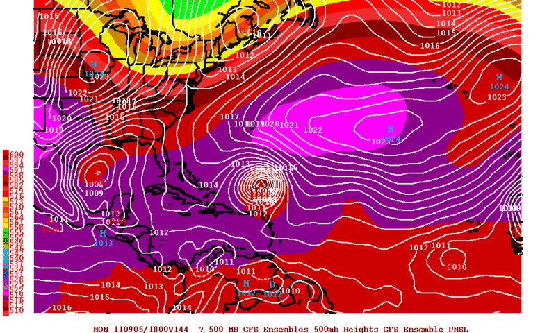
18zGFS Forecast valid for Monday September 5.
0 likes
The following post is NOT an official forecast and should not be used as such. It is just the opinion of the poster and may or may not be backed by sound meteorological data. It is NOT endorsed by any professional institution including storm2k.org For Official Information please refer to the NHC and NWS products.
-
StormClouds63
- Category 2

- Posts: 583
- Age: 62
- Joined: Tue May 13, 2008 11:56 am
- Location: Southwest Louisiana
Re: Gulf Homebrew? - 10%
djmikey wrote:My friend in Florida just sent me this from a FL met:
*5pm Tropical Update: Katia should be NO threat to the US. Disturbance should enter Gulf in a few days. Models split on development and location. Euro just has it linger before bringing weak system toward Florida next Tuesday. I want another run before jumping on board.
Why do I have this gut feeling TX won't be seeing much of anything from this but a high tide....
SW LA as well.
0 likes
-
South Texas Storms
- Professional-Met
- Posts: 4256
- Joined: Thu Jun 24, 2010 12:28 am
- Location: Houston, TX

Re: Gulf Homebrew? - 10%
Interesting 18z GFS solution - suggests weak steering currents - could have the whole gulf coast watching this one labor day weekend.
0 likes
-
stormhunter7

- Category 2
- Posts: 763
- Joined: Mon May 26, 2008 3:13 pm
- Location: Panama City Beach, Florida
- Contact:
Re: Gulf Homebrew? - 10%
RUC latest run appears the CGOM is going to become busy in less than 36 hours?
http://mag.ncep.noaa.gov/NCOMAGWEB/appcontroller?prevPage=Model&MainPage=index&image=&page=Param&cycle=08%2F30%2F2011+23UTC&rname=PRECIP+PARMS&pname=precip_p01&pdesc=&model=RUC&area=NAMER&cat=MODEL+GUIDANCE&fcast=Loop+All&areaDesc=North+America+-+US+Canada+and+northern+Mexico&prevArea=NAMER&currKey=model&returnToModel=&imageSize=M
http://mag.ncep.noaa.gov/NCOMAGWEB/appcontroller?prevPage=Model&MainPage=index&image=&page=Param&cycle=08%2F30%2F2011+23UTC&rname=PRECIP+PARMS&pname=precip_p01&pdesc=&model=RUC&area=NAMER&cat=MODEL+GUIDANCE&fcast=Loop+All&areaDesc=North+America+-+US+Canada+and+northern+Mexico&prevArea=NAMER&currKey=model&returnToModel=&imageSize=M
0 likes
The following post is NOT an official forecast and should not be used as such. It is just the opinion of the poster and may or may not be backed by sound meteorological data. It is NOT endorsed by any professional institution including storm2k.org For Official Information please refer to the NHC and NWS products. http://www.nhc.noaa.gov

Re: Re:
jpigott wrote:Aric Dunn wrote:NDG wrote:West wind reported on top of the hour by buoy 42056, but could be from near by thunderstorm as reported temperature is 3 degrees cooler than previous hour.
Conditions at 42056 as of
(5:50 pm CDT)
2250 GMT on 08/30/2011:
Wind Direction (WDIR): W ( 280 deg true )
Wind Speed (WSPD): 11.7 kts
Wind Gust (GST): 15.5 kts
Wave Height (WVHT): 4.3 ft
Dominant Wave Period (DPD): 7 sec
Average Period (APD): 5.4 sec
Mean Wave Direction (MWD): ESE ( 103 deg true )
Atmospheric Pressure (PRES): 29.79 in
Pressure Tendency (PTDY): -0.01 in ( Falling )
Air Temperature (ATMP): 81.5 °F
Water Temperature (WTMP): 86.9 °F
Dew Point (DEWP): 75.9 °F
Heat Index (HEAT): 88.3 °F
Actually i have been watching that buoy all day. since there is some good curvature in the low levels. to add to that ob... the last hour of measurements show a good wind shift.... from S to W
5:50 pm WNW ( 283 deg ) 10.5 kts
5:40 pm W ( 269 deg ) 10.7 kts
5:30 pm WSW ( 245 deg ) 11.8 kts
5:20 pm SW ( 231 deg ) 14.0 kts
5:10 pm SSW ( 203 deg ) 12.0 kts
5:00 pm S ( 176 deg ) 10.7 kts
What general area is that buoy located at?
Near 20N & 85W, about 150 miles east of Yucatan and 130 miles S of the western tip of Cuba.
0 likes
-
bamajammer4eva
- Category 4

- Posts: 907
- Joined: Sun Apr 18, 2010 3:21 am
- Location: Ozark, AL
Re: Gulf Homebrew? - 10%
cycloneye wrote:Remains at 10%.
TROPICAL WEATHER OUTLOOK
NWS NATIONAL HURRICANE CENTER MIAMI FL
800 PM EDT TUE AUG 30 2011
FOR THE NORTH ATLANTIC...CARIBBEAN SEA AND THE GULF OF MEXICO...
THE NATIONAL HURRICANE CENTER IS ISSUING ADVISORIES ON TROPICAL
STORM KATIA...LOCATED ABOUT 750 MILES WEST OF THE SOUTHERNMOST CAPE
VERDE ISLANDS.
A LARGE AREA OF DISORGANIZED CLOUDINESS AND SHOWERS OVER THE
NORTHWESTERN CARIBBEAN SEA IS ASSOCIATED WITH A TROPICAL WAVE.
THIS SYSTEM IS EXPECTED TO MOVE GENERALLY WESTWARD AT 10 TO 15 MPH
ACROSS THE NORTHERN PORTION OF YUCATAN PENINSULA DURING THE NEXT
DAY OR TWO...AND HAS SOME POTENTIAL FOR DEVELOPMENT OVER THE
CENTRAL OR WESTERN GULF OF MEXICO IN A FEW DAYS. THIS SYSTEM HAS A
LOW CHANCE...10 PERCENT...OF BECOMING A TROPICAL CYCLONE DURING THE
NEXT 48 HOURS.
ELSEWHERE...TROPICAL CYCLONE FORMATION IS NOT EXPECTED DURING THE
NEXT 48 HOURS.
$$
FORECASTER BROWN
Slight change in wording from the 1pm TWO which only mentioned development in the Western Gulf.
0 likes

Re: Gulf Homebrew? - 10%
Here's what Mobile NWS is saying about this in their afternoon Forecast Discussion:
Hope it goes your way Texas as y'all really need the rain... and we don't need anything strong like some of those models are trying to spin up!
LONG TERM (SATURDAY THROUGH TUESDAY)...THE LONG TERM PERIOD DEPENDS
HEAVILY ON THE ANTICIPATED DEVELOPMENT OF A LOW PRESSURE SYSTEM OVER
THE WESTERN GULF AND MOVEMENT OF THIS FEATURE. WHILE THE MODELS
HAVE GOOD CONSISTENCY ON DEVELOPMENT OF THIS SYSTEM...SUBSEQUENT
MOVEMENT HAS LITTLE CONSISTENCY. HPC IS GENERALLY A BLEND OF THE
ECMWF/GFS SOLUTIONS AND KEEPS THE SYSTEM OVER THE WESTERN GULF
THROUGH MONDAY...THEN MOVES THE SYSTEM NEAR THE TEXAS/MEXICO BORDER
ON TUESDAY. THIS SYSTEM WILL SEND INCREASING GULF MOISTURE INTO
THE FORECAST AREA AND ANTICIPATE INCREASING RAIN CHANCES THROUGH THE
LABOR DAY WEEKEND INTO TUESDAY...MAINLY OVER THE MARINE AREA AND
SOUTHERN PORTION OF THE FORECAST AREA...WITH MODERATED TEMPERATURES.
Hope it goes your way Texas as y'all really need the rain... and we don't need anything strong like some of those models are trying to spin up!
0 likes
-
Rgv20
- S2K Supporter
- Posts: 2466
- Age: 39
- Joined: Wed Jan 05, 2011 5:42 pm
- Location: Edinburg/McAllen Tx
Re: Gulf Homebrew? - 10%
South Texas Storms wrote:Rgv, where do you think this system will eventually make landfall?
It's hard to pinpoint a landfall but my best guess would be anywhere from SW LA to Northeastern Mexico.
0 likes
The following post is NOT an official forecast and should not be used as such. It is just the opinion of the poster and may or may not be backed by sound meteorological data. It is NOT endorsed by any professional institution including storm2k.org For Official Information please refer to the NHC and NWS products.
Who is online
Users browsing this forum: No registered users and 100 guests