
you guys need to relax about this rain....it will rain..as it moves weat and sw to put us on the eastern side....
ATL: LEE - Remnants - Discussion
Moderator: S2k Moderators
Re: ATL: INVEST 93L - Models
when is the HWRF not the outlier.....lol.....its always to far right and intensity nuts.... 
you guys need to relax about this rain....it will rain..as it moves weat and sw to put us on the eastern side....
you guys need to relax about this rain....it will rain..as it moves weat and sw to put us on the eastern side....
0 likes

Re: ATL: INVEST 93L - Models
Ivanhater wrote:True enough Wxman, except the Euro is not on that map and takes it NE like the HWRF.
Doesn't the Euro take it west and then up and down the Texas coast... Then off to the NE into La in like 6 or 7 days..
Last edited by pwrdog on Thu Sep 01, 2011 9:31 am, edited 1 time in total.
0 likes
Re: ATL: INVEST 93L - Models
Ivanhater wrote:True enough Wxman, except the Euro is not on that map and takes it NE like the HWRF.
the EURO took it south and west then up and out.....bigger loop if you will....we dont even have a center and what we presume to be a LLC is being sheared off as it moves WNW...bottom line is all of the rain will be on the east side for now....We will see if it will stall....I think it wont stall until its inland over SW LA....
0 likes
-
Ivanhater

- Storm2k Moderator

- Posts: 11221
- Age: 39
- Joined: Fri Jul 01, 2005 8:25 am
- Location: Pensacola
Re: ATL: INVEST 93L - Models
Yeah Rock, I just am not seeing anything to kick this within the next few days. I don't think the first trough will be strong enough to pick it up NE or the high behind it will be strong enough to kick it all the way west. The Euro is giving us this idea. It could bump onshore anywhere during this "stuck" period imo.
0 likes
Michael
-
CYCLONE MIKE
- Category 5

- Posts: 2183
- Joined: Tue Aug 31, 2004 6:04 pm
- Location: Gonzales, LA
Re: ATL: INVEST 93L - Models
BigA wrote:ConvergenceZone wrote:ROCK wrote:will be close to inland tonight IMO....current steering...
http://tropic.ssec.wisc.edu/real-time/d ... oom=&time=
Hmm, I'm confused, if it may be moving inland tonight/tomorrow, why would anyone be worried about a tropical storm/hurricane? It doesn't sound like it would even have much time to develop?....
Because not one of the models has it inland by tonight, or really even tomorrow night. The steering is expected to collapse today.
Thanks BigA was just going to ask when the models started stalling this out.
Ivan, that Euro run is nasty. Talk about some devastation around here. Its funny our NWS office is talking hybrid or sub-tropical strom development this morning. Wonder if this euro run will change their thinking.
0 likes
-
Stormcenter
- S2K Supporter

- Posts: 6689
- Joined: Wed Sep 03, 2003 11:27 am
- Location: Houston, TX
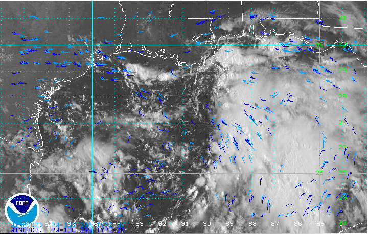
Here is a great sat. loop that shows pretty clearly what's trying to happen in the
N. Central GOM. IMO
http://weather.rap.ucar.edu/satellite/d ... uration=12
N. Central GOM. IMO
http://weather.rap.ucar.edu/satellite/d ... uration=12
0 likes
-
CYCLONE MIKE
- Category 5
- Posts: 2183
- Joined: Tue Aug 31, 2004 6:04 pm
- Location: Gonzales, LA
Re: ATL: INVEST 93L - Discussion
wxman57 wrote:I'm seeing several reports of 35kt SE winds already, which means another one skipping the TD stage and going straight to TS. No clear LLC yet, though.
wxman, what are your thoughts of our local NWS guys going with a hybrid or sub-tropical system when on the other hand the euro is showing a strong hurricane affecting us? Intensity wise, what are your thoughts once this gets going?
0 likes


Re: ATL: INVEST 93L - Models
wxman57 wrote:The HWRF is the outlier in taking "Lee" (or Maria) to the northeast toward Panama City. All other models now go for the stall then SW to west movement.
In addition, the 0z European Ensemble Prediction System Control shows a formidable TC impacting deep South Texas on Thursday and Friday of next week.
0 likes
Re: ATL: INVEST 93L - Models
pwrdog wrote:Ivanhater wrote:True enough Wxman, except the Euro is not on that map and takes it NE like the HWRF.
Doesn't the Euro take it west and then up and down the Texas coast... Then off to the NE into La in like 6 or 7 days..
The Euro takes it..
nw, sw, ne, nw, sw, nw, sw then NE and away..
I knew it was something like that..
0 likes
-
ConvergenceZone
.gif)
- Category 5
- Posts: 5241
- Joined: Fri Jul 29, 2005 1:40 am
- Location: Northern California
-
CYCLONE MIKE
- Category 5
- Posts: 2183
- Joined: Tue Aug 31, 2004 6:04 pm
- Location: Gonzales, LA
Re:
Stormcenter wrote:Here is a great sat. loop that shows pretty clearly what's trying to happen in the
N. Central GOM. IMO
http://weather.rap.ucar.edu/satellite/d ... uration=12
Nice loop stormcenter. One thing is for certain looks like we will be getting A LOT of rain. That plume runs all the way down into the Caribbean!
Another thing, I read a few posts back saying watch for weak llc around 26n 90w. Is it possible something could try and pop under the deeper convection around 25n 87w? Thoughts?
0 likes
-
HouTXmetro

- Category 5
- Posts: 3949
- Joined: Sun Jun 13, 2004 6:00 pm
- Location: District of Columbia, USA

Re: ATL: INVEST 93L - Discussion
To me it looks like a surface low at 26N 92W.
http://www.tropicalatlantic.com/satellite/custom/index.htm?satellite=GOES-E+CONUS&type=Animation&numframes=10&width=1000&height=800&info=vis&zoom=1&palette=ir.pal&quality=100&map=standard&mapcolor=black&lat=26&lon=-92
If convection starts firing close to this, UL winds are nearly ideal for ventilation.
Could ramp quickly.
Very strong CAPE at 4000 to 4500!
0 likes
-
TeamPlayersBlue

- Category 5
- Posts: 3530
- Joined: Tue Feb 02, 2010 1:44 am
- Location: Denver/Applewood, CO
Again, this storm stalling out in the gulf makes me quite uncomfortable. The longer it takes to develop in my opinion, the better. Unfortunately, i think the drought relief for Texas will be minimal if the storm doesnt head inland on our coast.
This storm stalling out in the gulf makes me very nervous though. People talk about the upwelling, and some dry air, but if this storm gets its act together, and stays over water, i see this as at least a cat 2 possibly stronger. Mitch stalled out and was a monster, Wilma, and of course Alicia which is a very similar situation as this storm. These are all historical cyclones but something we should be aware of.
Do we have any data on water temps at certain depths of the northern gulf? The shallow water is around 30C but what about 100ft down etc. This post is not meant to freak anybody out, but any criticism as to why this situation is much different from these systems is welcome.
The posts in this forum are NOT official forecast and should not be used as such. They are just the opinion of the poster and may or may not be backed by sound meteorological data. They are NOT endorsed by any professional institution or storm2k.org. For official information, please refer to the NHC and NWS products.
0 likes
Personal Forecast Disclaimer:
The posts in this forum are NOT official forecast and should not be used as such. They are just the opinion of the poster and may or may not be backed by sound meteorological data. They are NOT endorsed by any professional institution or storm2k.org. For official information, please refer to the NHC and NWS products.
The posts in this forum are NOT official forecast and should not be used as such. They are just the opinion of the poster and may or may not be backed by sound meteorological data. They are NOT endorsed by any professional institution or storm2k.org. For official information, please refer to the NHC and NWS products.
-
Ivanhater
- Storm2k Moderator
- Posts: 11221
- Age: 39
- Joined: Fri Jul 01, 2005 8:25 am
- Location: Pensacola
Re: ATL: INVEST 93L - Models
I'd like to add, that even if the first trough does not get it, I am not sure the ridge behind it will be strong enough to push it all the way inland to the west, just like the Euro is showing. We could literally have a hurricane meandering around in the Gulf for 5 days or more. Well see, but this sure is not a clear cut, one way destination. Could have a round trip, frenquent flyer on our hands!
0 likes
Michael
Re:
TeamPlayersBlue wrote:Again, this storm stalling out in the gulf makes me quite uncomfortable. The longer it takes to develop in my opinion, the better. Unfortunately, i think the drought relief for Texas will be minimal if the storm doesnt head inland on our coast.
This storm stalling out in the gulf makes me very nervous though. People talk about the upwelling, and some dry air, but if this storm gets its act together, and stays over water, i see this as at least a cat 2 possibly stronger. Mitch stalled out and was a monster, Wilma, and of course Alicia which is a very similar situation as this storm. These are all historical cyclones but something we should be aware of.
Do we have any data on water temps at certain depths of the northern gulf? The shallow water is around 30C but what about 100ft down etc. This post is not meant to freak anybody out, but any criticism as to why this situation is much different from these systems is welcome.
The posts in this forum are NOT official forecast and should not be used as such. They are just the opinion of the poster and may or may not be backed by sound meteorological data. They are NOT endorsed by any professional institution or storm2k.org. For official information, please refer to the NHC and NWS products.
Here is a link to Tropical Cyclone Heat Potential... There is a super warm deep eddy out there it could cross and a larger area of fairly thick warm water.... but overall the water in the gulf is prone to upwelling.. Near the coast it has saved us a few times.. http://www.aoml.noaa.gov/phod/cyclone/data/go.html
0 likes
-
Ivanhater
- Storm2k Moderator
- Posts: 11221
- Age: 39
- Joined: Fri Jul 01, 2005 8:25 am
- Location: Pensacola
Re: ATL: INVEST 93L - Models
00Z UKMET is in agreement with the Euro getting picked up by the trough. The problem is the UKMET gets picked up by the first trough, the Euro gets picked up by the second.

Uploaded with ImageShack.us

Uploaded with ImageShack.us
0 likes
Michael

-
Portastorm

- Storm2k Moderator
- Posts: 9955
- Age: 63
- Joined: Fri Jul 11, 2003 9:16 am
- Location: Round Rock, TX
- Contact:
Re:
gmr548 wrote:Interesting that, though the models look like someone just went wild with a box of crayons, they all agree it will not give any significant rain to central Texas. Story of the year -____-
Don't jump off the ledge just yet ... we have a long ways to go on this system!
0 likes
Any forecasts under my name are to be taken with a grain of salt. Get your best forecasts from the National Weather Service and National Hurricane Center.
Who is online
Users browsing this forum: No registered users and 6 guests