ATL: KATIA - Post Tropical - Discussion
Moderator: S2k Moderators

-
ozonepete
- Professional-Met

- Posts: 4743
- Joined: Mon Sep 07, 2009 3:23 pm
- Location: From Ozone Park, NYC / Now in Brooklyn, NY
Re: ATL: KATIA - Tropical Storm - Discussion
0 likes
-
WeatherLovingDoc

- S2K Supporter

- Posts: 453
- Joined: Fri Sep 05, 2008 10:08 pm
- Location: Washington D.C.
Re: ATL: KATIA - Tropical Storm - Discussion
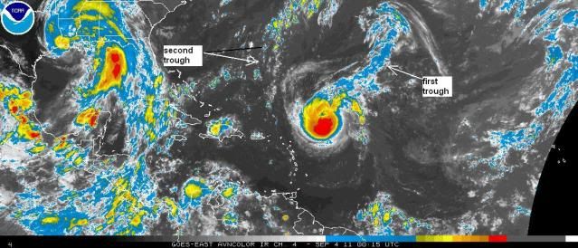
[quote="ozonepete"]:uarrow: (that microwave image is telling) I'm tellin' you it's on it's way. Look at this satellite image. I annotated it to show the two troughs of concern. Katia is just about past the first one, so the shear and northward pull from that one is pretty much over. The second one is weakening pretty steadily now, so it may have very little influence in pulling Katia north or shearing it. If the STR does build north of it after all, it will be a much closer call for the CONUS.
Thanks for labeling the troughs! Helps so much. This is an intersting storm to watch and learn from. Aren't they all?
Thanks for labeling the troughs! Helps so much. This is an intersting storm to watch and learn from. Aren't they all?
0 likes
-
Stephanie

- S2K Supporter
- Posts: 23843
- Age: 63
- Joined: Thu Feb 06, 2003 9:53 am
- Location: Glassboro, NJ
Re: ATL: KATIA - Tropical Storm - Discussion
ozonepete wrote:bexar wrote:poor Katia struggling. I wouldn't be surprised if she doesn't regain hurricane strength anymore. This year is just so hostile for CV development.
the shear and dry air in far east atlantic has been such a pest this year
Personal Forecast Disclaimer:
The posts in this forum are NOT official forecast and should not be used as such. They are just the opinion of the poster and may or may not be backed by sound meteorological data. They are NOT endorsed by any professional institution or storm2k.org. For official information, please refer to the NHC and NWS products.
Have you seen the last few hours on satellite presentation? And the latest CIMSS analysis?
Probably not.
0 likes


Re: ATL: KATIA - Tropical Storm - Discussion
ozonepete wrote::uarrow: (that microwave image is telling) I'm tellin' you it's on it's way. Look at this satellite image. I annotated it to show the two troughs of concern. Katia is just about past the first one, so the shear and northward pull from that one is pretty much over. The second one is weakening pretty steadily now, so it may have very little influence in pulling Katia north or shearing it. If the STR does build north of it after all, it will be a much closer call for the CONUS.
I thought that Tropical Storm Lee was the fly in the ointment (so to speak) regarding the future track of Katia. I know the troughs, of course, were also suppose to start the turns, but what exact effect will Lee have on Katia's track? Going to a wedding in SNE on Friday and really don't want to see a storm up there.
0 likes
-
sfwx

- Category 1

- Posts: 371
- Age: 60
- Joined: Thu Sep 04, 2003 1:53 pm
- Location: Rural St. Lucie County, Fl
Re: ATL: KATIA - Models
EXTENDED FORECAST DISCUSSION
NWS HYDROMETEOROLOGICAL PREDICTION CENTER CAMP SPRINGS MD
358 PM EDT SAT SEP 03 2011
VALID 12Z TUE SEP 06 2011 - 12Z SAT SEP 10 2011
FINAL GRAPHICS STAYED WITH THE PRELIM GRAPHICS OVER THE CONUS
MAKING ONLY MINOR CHANGES. THE GENERAL LONGWAVE TREND CONTINUES
TO BE A DEEP TROF S OF ALASKA...FLAT RIDGE OVER WRN NOAM...AND
TROF OVER FAR ERN NOAM. MEDIUM RANGE GUIDANCE HAS BEEN CONSISTENT
WITH AN AMPLIFIED THOUGH GRADUALLY WEAKENING S OF ALASKA AND A
DOWNSTREAM RIDGE PERSISTING OVER WRN NOAM. ACROSS CANADA...THE NEW
00Z/03 ECENS MEAN TRENDED TOWARDS FLATTER 500MB FLOW FROM ITS
CORRESPONDING 12Z/02 RUN FOR FRI/SAT DAYS 6-7. THE GENERAL TREND
IN GUIDANCE OVER THE PAST DAY IS TOWARD LESS AMPLITUDE WITH THE
BROAD ERN CANADA MEAN UPPER TROF.
IN THE 06Z/03 GUIDANCE WE NOTED THE UNCERTAINTY THAT THE 06Z/03
GFS/NAM HAD IN DECIDING HOW MUCH NRN STREAM ENERGY INTERACTS WITH
WEAKENING TS LEE. THE 06Z/03 GFS TRENDED FASTER...WHILE THE 06Z
NAM TRENDED SLOWER. 12Z MODELS TENDED TO CLUSTER FAIRLY WELL ON
CLOSING OFF AN UPPER LOW OVER
THE LWR OH/TN VLY AND ALLOWING IT TO MILL AROUND IN THAT AREA AT
LEAST INTO FRI DAY 6. THEY INCREASED OUR CONFIDENCE WITH DECENT
CLUSTERING ON THE LOWER OH/TN VLY UPPER LOW.
THE 12Z GFS FOLLOWS ITS OWN 00Z CONTINUITY RATHER WELL AND WAS IN
AGREEMENT WITH IT CORRESPONDING 00Z RUN ON MOST FEATURES. IT IS A
BIT FLATTER IN CANADA DAY 4...AND FASTER LIFTING OUT THE NRN
STREAM TROF ACROSS THE MARITIMES TUE...BUT THESE DIFFERENCES
SHOULD HAVE LITTLE IMPACT ON THE WEATHER OVER THE LOWER 48. 12Z
OPERATIONAL MODELS CONTINUE THE IDEA OF CLOSING OFF AN UPPER LOW
OVER THE E-CNTRL CONUS. FARTHER N...THEY TREND TOWARD LOWER
AMPLITUDE CONCERNING 500MB CANADIAN FLOW BY THU/FRI DAYS 5-6.
WITH LESS CHANCE FOR A PENETRATION OF WESTERLIES FROM CANADA INTO
THE LOWER 48...THIS TREND SEEMS COMPATIBLE WITH THE MEANDERING
LOWER OH VLY CLOSED LOW SOLN FAVORED BY THE DETERMINISTIC MODELS
DAYS 3-6.
OVER THE ERN CONUS EXPECT T.S. LEE TO TRANSITION TO AN
EXTRATROPICAL SYSTEM BY WED DAY 4. A SFC REFLECTION IS LIKELY TO
PERSIST AT LEAST THRU THU DAY 5 OR LONGER. THE MANUAL FCST
REFLECTS THE NHC FCST THRU DAY 5. REMNANTS OF LEE SHOULD BECOME
TIED INTO THE NEARBY UPPER LOW THEREAFTER. A LOT OF MOISTURE IS
AVAILABLE FROM THIS SYS TO PRODUCE HEAVY RAINFALL ALONG ITS TREK
FROM THE SERN STATES NE INTO THE MID ATLANTIC REGION/SRN NEW ENG.
A PRECURSOR HEAVY RUN EVENT MAY OCCUR ON THE COLD SIDE OF A FRONT
FROM THE SRN APPALACHIANS TO SRN NEW ENG TUE/WED.
12Z DETERMINISTIC MODEL GUIDANCE IS STILL FAIRLY DIVERSE WITH THE
TRACK OF HURCN KATIA OVER THE ATLC. THE 12Z GFS STRAYS TO THE
FAST AND RIGHT SIDE OF THE GUIDANCE ENVELOPE AS EARLY AS THU. THE
ECMWF...ON THE OTHER HAND...HAD SHIFTED TO THE FAR LEFT SIDE OF
THE SOLUTION ENVELOPE THRU FRI DAY 6...TO THE LATITUDE OF THE
UKMET BUT 4 DEGREES FARTHER W. THE NEW ECMWF TURNS KATIA A SHARPLY
TO THE RIGHT BEYOND THAT TIME BUT STILL GETS AS FAR W AS 74W
LONGITUDE ON FRI. PLEASE STAY INFORMED ON NHC DISCUSSIONS FOR
KATIA.
FLOOD
0 likes
-
ozonepete
- Professional-Met
- Posts: 4743
- Joined: Mon Sep 07, 2009 3:23 pm
- Location: From Ozone Park, NYC / Now in Brooklyn, NY
Re: ATL: KATIA - Tropical Storm - Discussion
I assume SNE is southern New England?  Well, unfortunatley there is a possibilty of it affecting that area around that time, so you will just have to watch and wait.
As far as Lee goes, yes you are quite right that it could have a BIG influence. If it moves into the southeast U.S. and stalls out and has an upper level presence at 500mb, where the steering winds for TCs are, it could pull Katia closer or even inland in the northeast. Lee is the big wildcard, and it's just too early to trust any model resolutions. We will not have a good handle on it until Tuesday at the earliest.
As far as Lee goes, yes you are quite right that it could have a BIG influence. If it moves into the southeast U.S. and stalls out and has an upper level presence at 500mb, where the steering winds for TCs are, it could pull Katia closer or even inland in the northeast. Lee is the big wildcard, and it's just too early to trust any model resolutions. We will not have a good handle on it until Tuesday at the earliest.
0 likes
-
Stephanie
- S2K Supporter
- Posts: 23843
- Age: 63
- Joined: Thu Feb 06, 2003 9:53 am
- Location: Glassboro, NJ
Re: ATL: KATIA - Tropical Storm - Discussion
ozonepete wrote:I assume SNE is southern New England?
As far as Lee goes, yes you are quite right that it could have a BIG influence. If it moves into the southeast U.S. and stalls out and has an upper level presence at 500mb, where the steering winds for TCs are, it could pull Katia closer or even inland in the northeast. Lee is the big wildcard, and it's just too early to trust any model resolutions. We will not have a good handle on it until Tuesday at the earliest.
Can you imagine the two of them COMBINED?? I hope they both stay FAR away from Upstate NY & VT.
0 likes
Re: ATL: KATIA - Tropical Storm - Discussion
ozonepete wrote:I assume SNE is southern New England?
As far as Lee goes, yes you are quite right that it could have a BIG influence. If it moves into the southeast U.S. and stalls out and has an upper level presence at 500mb, where the steering winds for TCs are, it could pull Katia closer or even inland in the northeast. Lee is the big wildcard, and it's just too early to trust any model resolutions. We will not have a good handle on it until Tuesday at the earliest.
Thanks Ozonepete.. appreciate your input.
0 likes
-
ozonepete
- Professional-Met
- Posts: 4743
- Joined: Mon Sep 07, 2009 3:23 pm
- Location: From Ozone Park, NYC / Now in Brooklyn, NY
Re: ATL: KATIA - Tropical Storm - Discussion
pgoss11 wrote:ozonepete wrote:I assume SNE is southern New England?
As far as Lee goes, yes you are quite right that it could have a BIG influence. If it moves into the southeast U.S. and stalls out and has an upper level presence at 500mb, where the steering winds for TCs are, it could pull Katia closer or even inland in the northeast. Lee is the big wildcard, and it's just too early to trust any model resolutions. We will not have a good handle on it until Tuesday at the earliest.
Thanks Ozonepete.. appreciate your input.
You're welcome. Good luck.
0 likes
-
ozonepete
- Professional-Met
- Posts: 4743
- Joined: Mon Sep 07, 2009 3:23 pm
- Location: From Ozone Park, NYC / Now in Brooklyn, NY
Re: ATL: KATIA - Tropical Storm - Discussion
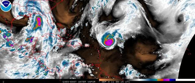
Here's the water vapor image. Although most people use this to see where most of the atmosphere is quite moist, which is necessary for tropical cyclone development and maintenance, you SHOULDN'T use it for key MID-LEVEL moisture. Here are a couple of important points about it:
1. This always picks up higher level moisture but often MISSES mid and lower level water vapor. High level dry air is actually no problem for a tropical cyclone; they need moisture ONLY at low and mid-levels. Thus it should NOT be used to see how moist the environment is for a tropical cyclone.
2. It is a very good tool for detecting upper level features such as troughs and lows, which have a big effect on tropical cyclone track and shear. In other words, it can give you big hints of the general movement of the atmosphere around a TC and thus help you figure out what the steeering is doing and how much shear may be occurring.
Here is the link to the full WV loop:
http://www.ssd.noaa.gov/goes/east/tatl/flash-wv.html
Last edited by ozonepete on Sat Sep 03, 2011 8:37 pm, edited 1 time in total.
0 likes
-
ozonepete
- Professional-Met
- Posts: 4743
- Joined: Mon Sep 07, 2009 3:23 pm
- Location: From Ozone Park, NYC / Now in Brooklyn, NY
Re: ATL: KATIA - Tropical Storm - Discussion
So where do see those key charts of mid-level water vapor? At CIMSS:
http://tropic.ssec.wisc.edu/real-time/salmain.php?&prod=wvmid&time=
http://tropic.ssec.wisc.edu/real-time/salmain.php?&prod=wvmid&time=
0 likes
Re: ATL: KATIA - Tropical Storm - Discussion
[quote="ozonepete"]Here's the water vapor image. Although most people use this to see where most of the atmosphere is quite moist, which is necessary for tropical cyclone development and maintenance, you SHOULDN'T. Here are a couple of important points about it:
1. This always picks up higher level moisture but often MISSES mid and lower level water vapor. High level dry air is actually no problem for a tropical cyclone; they need moisture ONLY at low and mid-levels. Thus it should NOT be used to see how moist the environment is for a tropical cyclone.
2. It is a very good tool for detecting upper level features such as troughs and lows, which have a big effect on tropical cyclone track and shear. In other words, it can give you big hints of the general movement of the atmosphere around a TC and thus help you figure out what the steeering is doing and how much shear may be occurring.
That really does show that Katia' s passed by the first trough untouched and the second trough appears to be weakening quite a bit. She should move wnw for awhle it seems until we see what Lee is going to do.
Last edited by pgoss11 on Sat Sep 03, 2011 8:40 pm, edited 1 time in total.
0 likes
-
gatorcane

- S2K Supporter
- Posts: 23708
- Age: 48
- Joined: Sun Mar 13, 2005 3:54 pm
- Location: Boca Raton, FL
Re: ATL: KATIA - Tropical Storm - Discussion
ozonepete wrote:So where do see those key charts of mid-level water vapor? At CIMSS:
http://tropic.ssec.wisc.edu/real-time/salmain.php?&prod=wvmid&time=
Thanks ozonepete for the discussion for our member of what the water vapor loop image provides
0 likes

-
gatorcane
- S2K Supporter
- Posts: 23708
- Age: 48
- Joined: Sun Mar 13, 2005 3:54 pm
- Location: Boca Raton, FL
You can see the trough starting to dig over North Dakota and Minnesota.
That trough should move east and possibly connect with Lee to create a trough along the eastern seaboard of the United States that could deflect Katia.
http://www.ssd.noaa.gov/goes/east/eaus/loop-wv.html
That trough should move east and possibly connect with Lee to create a trough along the eastern seaboard of the United States that could deflect Katia.
http://www.ssd.noaa.gov/goes/east/eaus/loop-wv.html
0 likes
-
meriland23

- Category 5

- Posts: 1239
- Age: 38
- Joined: Mon Aug 29, 2011 9:29 pm
Re:
gatorcane wrote:You can see the trough starting to dig over North Dakota and Minnesota.
That trough should move east and possibly connect with Lee to create a trough along the eastern seaboard of the United States that could deflect Katia.
http://www.ssd.noaa.gov/goes/east/eaus/loop-wv.html
Trust me when I say he is totally right. I live in Minnesota and it was super chilly today. Yesterday I was in a tank, today I wore a coat outside...
0 likes
The posts in this forum are NOT official forecast and should not be used as such. They are just the opinion of the poster and may or may not be backed by sound meteorological data. They are NOT endorsed by any professional institution or storm2k.org. For official information, please refer to the NHC and NWS products.
-
ozonepete
- Professional-Met
- Posts: 4743
- Joined: Mon Sep 07, 2009 3:23 pm
- Location: From Ozone Park, NYC / Now in Brooklyn, NY
Re: ATL: KATIA - Tropical Storm - Discussion
0 likes
-
ozonepete
- Professional-Met
- Posts: 4743
- Joined: Mon Sep 07, 2009 3:23 pm
- Location: From Ozone Park, NYC / Now in Brooklyn, NY
Re: Re:
meriland23 wrote:gatorcane wrote:You can see the trough starting to dig over North Dakota and Minnesota.
That trough should move east and possibly connect with Lee to create a trough along the eastern seaboard of the United States that could deflect Katia.
http://www.ssd.noaa.gov/goes/east/eaus/loop-wv.html
Trust me when I say he is totally right. I live in Minnesota and it was super chilly today. Yesterday I was in a tank, today I wore a coat outside...
Man, you're pickin' stuff up fast. I never said welcome, but welcome! (And you can keep the coat! Yugghh, I'm just not ready yet.)
0 likes
Who is online
Users browsing this forum: No registered users and 29 guests