


ATL: LEE - Remnants - Discussion
Moderator: S2k Moderators
-
Kory
- Tropical Storm

- Posts: 200
- Age: 30
- Joined: Tue Aug 02, 2011 11:32 am
- Location: New Orleans, Louisiana
Re: ATL: LEE - Tropical Storm - Discussion
TexWx wrote:Stalled again?
Looks that way. Probably just a short term thing since the trough is going to pull it to the NE soon. But who knows with this system...
0 likes
-
Janie2006

- Category 5

- Posts: 1329
- Joined: Mon Sep 18, 2006 3:28 pm
- Location: coastal Ms aka home of the hurricanes
Re: ATL: LEE - Tropical Storm - Discussion
The front is approaching and at a fairly rapid clip. Lee (or what's left of him) won't be sitting still much longer.
0 likes
-
midnight8

- Tropical Depression

- Posts: 75
- Age: 52
- Joined: Sat Aug 14, 2010 3:05 pm
- Location: Orange, Texas
Re: ATL: LEE - Tropical Storm - Discussion
A 77 degree day courtesy of Lee. I thank him for that.
0 likes
KF5KWF Orange, Texas
-
gone2beach

- S2K Supporter

- Posts: 70
- Joined: Wed Aug 27, 2008 1:20 pm
- Location: Long Beach, MS
-
PTrackerLA

- Category 5
- Posts: 5281
- Age: 42
- Joined: Thu Oct 10, 2002 8:40 pm
- Location: Lafayette, LA
-
bamajammer4eva
- Category 4

- Posts: 907
- Joined: Sun Apr 18, 2010 3:21 am
- Location: Ozark, AL
Re: ATL: LEE - Tropical Storm - Discussion
Unwarned tornado touched down in Rainbow City near Gadsden, AL around 4pm.
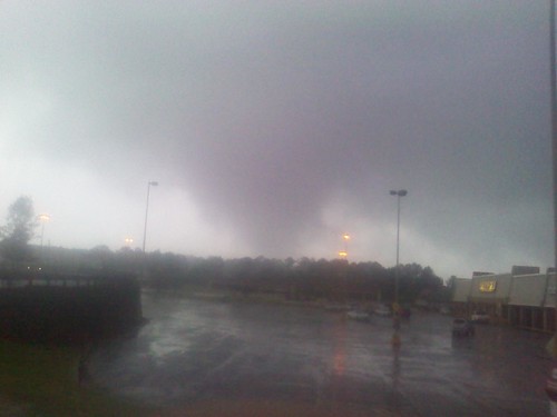
Rainbow City Tornado by abc3340weather, on Flickr
BMX: 4 Ssw Gadsden [Etowah Co, AL] emergency mngr reports TORNADO at 03:50 PM CDT -- evidence points toward a weak tornado touch down in rainbow city. several trees were blown down and some minor structure damage occurred near the rainbow city city hall on highway 411. a few eyewitnesses saw a funnel and debris in the air. a few photos of the funnel were captured.
Rainbow City Tornado by abc3340weather, on Flickr
0 likes
-
Houstonia

- S2K Supporter
- Posts: 829
- Age: 61
- Joined: Fri Oct 11, 2002 9:45 am
- Location: Sharpstown, Houston, Harris County, Southeast Texas.
Re: ATL: LEE - Tropical Storm - Discussion
Shoshana wrote:vbhoutex wrote:Turtle wrote:I live along I-20 in East Texas and just got a 43 MPH gust. Some of my potted plants have been knocked over!
It has been quite windy here in Houston but I haven't seen any rain, at least on the West side. Gusts have been to 37 mph which I find strange considering how far W of the center we are.
Gusts to 44 mph here in Austin (airport). Local news says it's Lee but ...
Unfortunately, the wind is causing a LOT of problems for firefighters.
http://www.reuters.com/article/2011/09/04/us-storm-usa-gulf-texas-idUSTRE78322P20110904
0 likes
Re: ATL: LEE - Tropical Storm - Discussion
Houstonia wrote:Shoshana wrote:vbhoutex wrote:It has been quite windy here in Houston but I haven't seen any rain, at least on the West side. Gusts have been to 37 mph which I find strange considering how far W of the center we are.
Gusts to 44 mph here in Austin (airport). Local news says it's Lee but ...
Unfortunately, the wind is causing a LOT of problems for firefighters.
http://www.reuters.com/article/2011/09/04/us-storm-usa-gulf-texas-idUSTRE78322P20110904
Lots of fires with the wind from North Texas down thru Central Texas.
0 likes
-
cycloneye

- Admin

- Posts: 148888
- Age: 69
- Joined: Thu Oct 10, 2002 10:54 am
- Location: San Juan, Puerto Rico
Re: ATL: LEE - Advisories
BULLETIN
TROPICAL STORM LEE INTERMEDIATE ADVISORY NUMBER 13A
NWS NATIONAL HURRICANE CENTER MIAMI FL AL132011
700 PM CDT SUN SEP 04 2011
...HEAVY RAINS AND FLOODING FROM LEE WILL SPREAD FROM THE CENTRAL
GULF COAST INTO THE SOUTHERN APPALACHIANS...
SUMMARY OF 700 PM CDT...0000 UTC...INFORMATION
----------------------------------------------
LOCATION...30.9N 91.8W
ABOUT 45 MI...75 KM SE OF ALEXANDRIA LOUISIANA
ABOUT 45 MI...75 KM WNW OF BATON ROUGE LOUISIANA
MAXIMUM SUSTAINED WINDS...40 MPH...65 KM/H
PRESENT MOVEMENT...N OR 5 DEGREES AT 6 MPH...9 KM/H
MINIMUM CENTRAL PRESSURE...989 MB...29.20 INCHES
WATCHES AND WARNINGS
--------------------
CHANGES WITH THIS ADVISORY...
NONE
SUMMARY OF WATCHES AND WARNINGS IN EFFECT...
A TROPICAL STORM WARNING IS IN EFFECT FOR...
* DESTIN FLORIDA WESTWARD TO MORGAN CITY LOUISIANA...INCLUDING THE
CITY OF NEW ORLEANS...LAKE PONTCHARTRAIN...AND LAKE MAUREPAS
FOR STORM INFORMATION SPECIFIC TO YOUR AREA IN THE UNITED STATES...
INCLUDING POSSIBLE INLAND WATCHES AND WARNINGS...PLEASE MONITOR
PRODUCTS ISSUED BY YOUR LOCAL NATIONAL WEATHER SERVICE FORECAST
OFFICE.
DISCUSSION AND 48-HOUR OUTLOOK
------------------------------
AT 700 PM CDT...0000 UTC...THE CENTER OF TROPICAL STORM LEE WAS
LOCATED NEAR LATITUDE 30.9 NORTH...LONGITUDE 91.8 WEST. LEE IS
MOVING TOWARD THE NORTH NEAR 6 MPH...9 KM/H. SOME ERRATIC MOTION IS
POSSIBLE THIS EVENING BEFORE LEE TURNS TOWARD THE NORTHEAST OR
EAST-NORTHEAST BY LATE TONIGHT. ON THE FORECAST TRACK...THE CENTER
OF LEE WILL MOVE SLOWLY ACROSS SOUTHERN AND SOUTHEASTERN LOUISIANA
TONIGHT...AND MOVE INTO SOUTHERN MISSISSIPPI BY LATE MONDAY.
MAXIMUM SUSTAINED WINDS HAVE DECREASED TO NEAR 40 MPH...65 KM/H...
WITH HIGHER GUSTS...AND THESE STRONGEST WINDS ARE OCCURRING WELL
SOUTHEAST OF THE CENTER OVER WATER. LITTLE CHANGE IN STRENGTH IS
EXPECTED IN THE NEXT 24 TO 36 HOURS.
TROPICAL-STORM-FORCE WINDS EXTEND OUTWARD UP TO 275 MILES...445
KM...MAINLY TO THE SOUTHEAST OF THE CENTER OVER WATER.
REPORTS FROM SURFACE OBSERVATIONS INDICATE THAT THE MINIMUM CENTRAL
PRESSURE IS 989 MB...29.20 INCHES.
HAZARDS AFFECTING LAND
----------------------
RAINFALL...TROPICAL STORM LEE IS EXPECTED TO PRODUCE TOTAL RAIN
ACCUMULATIONS OF 10 TO 15 INCHES ACROSS THE CENTRAL GULF COAST
REGION...WITH POSSIBLE ISOLATED MAXIMUM AMOUNTS OF 20 INCHES
THROUGH TUESDAY. HEAVY RAINS WILL CONTINUE TO EXPAND NORTHEASTWARD
INTO THE TENNESSEE VALLEY AND SOUTHERN APPALACHIAN MOUNTAINS
THROUGH TUESDAY WITH RAINFALL AMOUNTS OF 4 TO 8 INCHES EXPECTED...
WITH ISOLATED AMOUNTS OF 10 INCHES POSSIBLE. THESE RAINS ARE
EXPECTED TO CAUSE EXTENSIVE FLOODING AND FLASH FLOODING. SINCE
THURSDAY MORNING NEW ORLEANS INTERNATIONAL AIRPORT HAS REPORTED A
STORM-TOTAL RAINFALL OF 10.60 INCHES.
STORM SURGE...ELEVATED WATER LEVELS OF AS MUCH AS 3 TO 5 FEET ABOVE
GROUND LEVEL WILL CONTINUE TO OCCUR OVER PORTIONS OF SOUTHEASTERN
LOUISIANA AND COASTAL PORTIONS OF WESTERN MISSISSIPPI...WITH
ELEVATED WATER LEVELS AS MUCH AS 1 TO 3 FEET ABOVE GROUND LEVEL
ELSEWHERE WITHIN THE TROPICAL STORM WARNING AREA. ELEVATED WATER
LEVELS WILL BE SLOW TO RECEDE DUE TO PERSISTENT ONSHORE WINDS.
WIND...TROPICAL STORM CONDITIONS ARE EXPECTED TO CONTINUE OVER
PORTIONS OF THE WARNING AREA TONIGHT AND MONDAY.
TORNADOES...A FEW TORNADOES ARE POSSIBLE TONIGHT AND MONDAY OVER
PORTIONS OF SOUTHERN LOUISIANA...SOUTHERN MISSISSIPPI...SOUTHERN
ALABAMA...THE FLORIDA PANHANDLE...AND EXTREME SOUTHWESTERN GEORGIA.
NEXT ADVISORY
-------------
NEXT COMPLETE ADVISORY...1000 PM CDT.
$$
FORECASTER BRENNAN
0 likes
Visit the Caribbean-Central America Weather Thread where you can find at first post web cams,radars
and observations from Caribbean basin members Click Here
and observations from Caribbean basin members Click Here
-
cycloneye
- Admin
- Posts: 148888
- Age: 69
- Joined: Thu Oct 10, 2002 10:54 am
- Location: San Juan, Puerto Rico
Re: ATL: LEE - Tropical Storm - Discussion
...HEAVY RAINS AND FLOODING FROM LEE WILL SPREAD FROM THE CENTRAL
GULF COAST INTO THE SOUTHERN APPALACHIANS...
SUMMARY OF 700 PM CDT...0000 UTC...INFORMATION
----------------------------------------------
LOCATION...30.9N 91.8W
ABOUT 45 MI...75 KM SE OF ALEXANDRIA LOUISIANA
ABOUT 45 MI...75 KM WNW OF BATON ROUGE LOUISIANA
MAXIMUM SUSTAINED WINDS...40 MPH...65 KM/H
PRESENT MOVEMENT...N OR 5 DEGREES AT 6 MPH...9 KM/H
MINIMUM CENTRAL PRESSURE...989 MB...29.20 INCHES
0 likes
Visit the Caribbean-Central America Weather Thread where you can find at first post web cams,radars
and observations from Caribbean basin members Click Here
and observations from Caribbean basin members Click Here

-
vbhoutex

- Storm2k Executive
- Posts: 29141
- Age: 74
- Joined: Wed Oct 09, 2002 11:31 pm
- Location: Cypress, TX
- Contact:
Re: ATL: LEE - Tropical Storm - Discussion
Turtle wrote:I live along I-20 in East Texas and just got a 43 MPH gust. Some of my potted plants have been knocked over!
vbhoutex wrote:It has been quite windy here in Houston but I haven't seen any rain, at least on the West side. Gusts have been to 37 mph which I find strange considering how far W of the center we are.
Shoshana wrote:Gusts to 44 mph here in Austin (airport). Local news says it's Lee but ...
Houstonia wrote:Unfortunately, the wind is causing a LOT of problems for firefighters.
http://www.reuters.com/article/2011/09/04/us-storm-usa-gulf-texas-idUSTRE78322P20110904
I have started a thread in the USA and Caribbean Weather forum about the Texas wildfires. http://www.storm2k.org/phpbb2/viewtopic.php?f=24&p=2188280#p2188280
0 likes
Skywarn, C.E.R.T.
Please click below to donate to STORM2K to help with the expenses of keeping the site going:

Please click below to donate to STORM2K to help with the expenses of keeping the site going:


Re: ATL: LEE - Tropical Storm - Discussion
Looks like there has been damage in Mobile and Baldwin County from suspected tornadoes but nothing confirmed yet.
http://www2.wkrg.com/weather/2011/sep/02/54/tropical-storm-lee-forms-gulf-coast-ar-2356037/
http://www.fox10tv.com/dpp/weather/hurricane/possible-tornado-hits-lillian
http://www.local15tv.com/default.aspx
We have had some rough weather this afternoon and I have a feeling as TS Lee makes that turn toward the East it is going to get kind of rocky for us down here in MS, Alabama, and FL.
The posts in this forum are NOT official forecast and should not be used as such. They are just the opinion of the poster and may or may not be backed by sound meteorological data. They are NOT endorsed by any professional institution or storm2k.org. For official information, please refer to the NHC and NWS products
0 likes
Re: ATL: LEE - Tropical Storm - Discussion
Honestly Lee looked to have better structure over land today than he ever had over water for the most part.Had some OK winds about 1-2:30 PM this afternoon steady for that time at maybe 25-30mph in Biloxi.I do not know if anyone else posted but the tide on the beach must of came up some awful close to the seawall.Some of the vendors small crafts within 20yards of Hwy90 this morning with plenty of sand to the point one needed to drive down the center of the Eastbound lane at times.I usually look to August as our tough part of the season but by the looks of the models if they are to be believed all of us need to be watching.
0 likes

Re: ATL: LEE - Tropical Storm - Discussion
Noob here but been lurking since Alex last year.. very windy in Austin, actually has brought down a fence in my neighborhood...
great to on-board!
great to on-board!
0 likes
Carla 61, Alicia 83
The posts in this forum are NOT official forecast and should not be used as such. They are just the opinion of the poster and may or may not be backed by sound meteorological data. They are NOT endorsed by any professional institution or storm2k.org. For official information, please refer to the NHC and NWS products.
The posts in this forum are NOT official forecast and should not be used as such. They are just the opinion of the poster and may or may not be backed by sound meteorological data. They are NOT endorsed by any professional institution or storm2k.org. For official information, please refer to the NHC and NWS products.

Re: ATL: LEE - Tropical Storm - Discussion
Didn't know Mark was in town... And with Cantore to boot!!

The Weather Channel's Jim Cantore reports on Tropical Storm Lee from the beach in Biloxi.
The Weather Channel's Jim Cantore reports on Tropical Storm Lee from the beach in Biloxi.
0 likes
Betsy '65, Camille '69, Frederic '79, Elena '85, Georges '98, Isidore '02, Katrina '05, Isaac '12, Nate '17
-
Janie2006
- Category 5
- Posts: 1329
- Joined: Mon Sep 18, 2006 3:28 pm
- Location: coastal Ms aka home of the hurricanes
Re: ATL: LEE - Tropical Storm - Discussion
I get the impression that people I know (off these boards) think everything is over and done. Maybe it's a case of short attention spans. In any case, it's not quite over. Lee is going to interact with the approaching trough and produce a lot of heavy rain as it stumbles north and northeast.
[off-topic] And I'm not enjoying the model output, although I'm not quite buying some of the solutions for next week and beyond. [/off-topic]
[off-topic] And I'm not enjoying the model output, although I'm not quite buying some of the solutions for next week and beyond. [/off-topic]
0 likes
Re: ATL: LEE - Tropical Storm - Discussion
Ixolib wrote:Didn't know Mark was in town... And with Cantore to boot!!
The Weather Channel's Jim Cantore reports on Tropical Storm Lee from the beach in Biloxi.
What is the website address on the truck? I can make out something track.com ?
THanks
0 likes
-
Houstonia
- S2K Supporter
- Posts: 829
- Age: 61
- Joined: Fri Oct 11, 2002 9:45 am
- Location: Sharpstown, Houston, Harris County, Southeast Texas.
Re: ATL: LEE - Tropical Storm - Discussion
vbhoutex wrote:Turtle wrote:I live along I-20 in East Texas and just got a 43 MPH gust. Some of my potted plants have been knocked over!vbhoutex wrote:It has been quite windy here in Houston but I haven't seen any rain, at least on the West side. Gusts have been to 37 mph which I find strange considering how far W of the center we are.Shoshana wrote:Gusts to 44 mph here in Austin (airport). Local news says it's Lee but ...Houstonia wrote:Unfortunately, the wind is causing a LOT of problems for firefighters.
http://www.reuters.com/article/2011/09/04/us-storm-usa-gulf-texas-idUSTRE78322P20110904
I have started a thread in the USA and Caribbean Weather forum about the Texas wildfires. http://www.storm2k.org/phpbb2/viewtopic.php?f=24&p=2188280#p2188280
That took me to something about Tropical Storm Lee. Try this, I think this is what you meant : http://www.storm2k.org/phpbb2/viewtopic.php?f=24&t=111789
0 likes
Who is online
Users browsing this forum: No registered users and 73 guests