(Mabry) Tues Day 84 100+ (New All Time Record) New High Record for Day
Day 25 105+
27 in a row 100+ current record 2011!
(Bergstrom) Tues Day 70 100+ (New All Time Record) New High Record for Day
C/S TX Weather: Seasonal with some rains
Moderator: S2k Moderators
Forum rules

The posts in this forum are NOT official forecast and should not be used as such. They are just the opinion of the poster and may or may not be backed by sound meteorological data. They are NOT endorsed by any professional institution or STORM2K.
-
Tireman4

- S2K Supporter

- Posts: 5903
- Age: 60
- Joined: Fri Jun 30, 2006 1:08 pm
- Location: Humble, Texas
- Contact:
For us too. The afternoon met is asking the question we all beg to ask...
MORE HIGH TEMPERATURE RECORDS FOR HOUSTON (NEW)...HOUSTON HOBBY
(TIE) AND COLLEGE STATION (TIE). AS OF 3 PM...IAH REACHED 102
DEGREES...HOU REACHED 97 DEGREES AND COLLEGE STATION WAS 102 DEGREES.
2011 NOW CONTAINS THE EARLIEST 102 DEGREE DAY IN CITY OF HOUSTON
WEATHER HISTORY AND LATEST 102 DEGREE DAY IN HOUSTON WEATHER HISTORY.
BOOKENDS OF HEAT ON THE MOST INFAMOUS SUMMER ON RECORD. WHEN IS
FALL? 43
http://forecast.weather.gov/product.php ... glossary=1
0 likes


-
Radiogirltx

- Tropical Low

- Posts: 24
- Age: 52
- Joined: Tue Jul 26, 2011 10:28 pm
- Location: Port Lavaca, Tx
Re: C/S TX Weather: Extreme Fire Danger!
I know looking at forecasts over 4 days out can be like beating your head on the wall.....but here it goes anyway.....
I live on the mid-Tx coast In Port lavaca. Our forcast for next wed calls for a 60% chance of rain, and Thur a 40%. I can't figure out what weather feature could be causing this forecast. Any ideas? ( not that I'm complaining, just don't wanna get my hopes up......again...)
I live on the mid-Tx coast In Port lavaca. Our forcast for next wed calls for a 60% chance of rain, and Thur a 40%. I can't figure out what weather feature could be causing this forecast. Any ideas? ( not that I'm complaining, just don't wanna get my hopes up......again...)
0 likes


Re: C/S TX Weather: Extreme Fire Danger!
Radiogirltx wrote:I know looking at forecasts over 4 days out can be like beating your head on the wall.....but here it goes anyway.....
I live on the mid-Tx coast In Port lavaca. Our forcast for next wed calls for a 60% chance of rain, and Thur a 40%. I can't figure out what weather feature could be causing this forecast. Any ideas? ( not that I'm complaining, just don't wanna get my hopes up......again...)
Winds starting tomorrow will veer southerly to southeasterly ahead of a power cold front (bringing freeze and frost advisories to northern plains). This will bring up moisture and higher humidity levels. The front will stall around I-20 the next few days triggering storms.
By Thurs/Friday it will have an extra push from a strong trough and swing through Texas. With higher moisture levels already streaming in before then, there will be chances for rain as the front acts as a forcing mechanism. What's different with this front vs last is that there is no tropical system to drain moisture from us. Still hit and miss though. Could repeat again next week.
0 likes
The above post and any post by Ntxw is NOT an official forecast and should not be used as such. It is just the opinion of the poster and may or may not be backed by sound meteorological data. It is NOT endorsed by any professional institution including Storm2k. For official information, please refer to NWS products.
Help support Storm2K!
-
SaskatchewanScreamer
 tonight
 It's been raining on and off here this morning, what a thing of beauty, front is causing more lift than I saw on some of the models. Looking at radars to the west could be continued scattered on an off for much of the early afternoon until the front flies on by. Wish I could get some of this to build down a bit more south to the fire areas...
0 likes
The above post and any post by Ntxw is NOT an official forecast and should not be used as such. It is just the opinion of the poster and may or may not be backed by sound meteorological data. It is NOT endorsed by any professional institution including Storm2k. For official information, please refer to NWS products.
Help support Storm2K!
Help support Storm2K!
-
gboudx

- S2K Supporter
- Posts: 4090
- Joined: Thu Sep 04, 2003 1:39 pm
- Location: Rockwall, Tx but from Harvey, La
Re:
Ntxw wrote:It's been raining on and off here this morning, what a thing of beauty, front is causing more lift than I saw on some of the models. Looking at radars to the west could be continued scattered on an off for much of the early afternoon until the front flies on by. Wish I could get some of this to build down a bit more south to the fire areas...
Yeah it's been nice to see the pavement ever so damp from time-to-time. It's not much, but beggars can't be choosers.
0 likes
Seeing tons of facebook posts from friends back home in DFW about the rain. Even if it's not much, can't help but be happy. Forecasts evidently have the front heading down here and giving us a ~30% chance of rain through the weekend and into the middle of next week. I'm not holding my breath.
0 likes
-
wxman22

- Category 5

- Posts: 1948
- Joined: Mon Jan 30, 2006 12:39 am
- Location: Wichita Falls, TX
- Contact:
Re: C/S TX Weather: Extreme Fire Danger!
The 12z Euro actually shows numerous showers and thunderstorms over the state next week fwiw...
0 likes
(Mabry) Wed Day 85 100+ (New All Time Record) New High Record for Day
Day 25 105+
27 in a row 100+ current record 2011!
(Bergstrom) Wed Day 71 100+ (New All Time Record) New High Record for Day
Will this be our last day of 100+ for 2011? Or are we trying for Wichita Falls' mythical 100 days? Only time will tell! (and no, I can't see us getting 15 more days over 100. )
0 likes
-
Rgv20

- S2K Supporter
- Posts: 2466
- Age: 39
- Joined: Wed Jan 05, 2011 5:42 pm
- Location: Edinburg/McAllen Tx
Just a little update on the drought situation in Deep South Texas courtesy of the NWS in Brownsville.
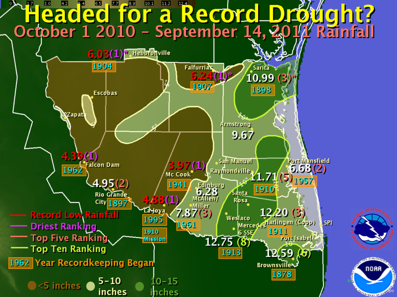
My little town of Rio Grande City has officially only receive 4.95 inches of Rainfall since October 1, 2010!!!!
My little town of Rio Grande City has officially only receive 4.95 inches of Rainfall since October 1, 2010!!!!
0 likes
The following post is NOT an official forecast and should not be used as such. It is just the opinion of the poster and may or may not be backed by sound meteorological data. It is NOT endorsed by any professional institution including storm2k.org For Official Information please refer to the NHC and NWS products.
-
gboudx
- S2K Supporter
- Posts: 4090
- Joined: Thu Sep 04, 2003 1:39 pm
- Location: Rockwall, Tx but from Harvey, La
Update from jeff this morning. There's hope for rain.
Increasing rain chances and cooler temperatures!
Weak frontal boundary is drifting southward across Texas this morning with widespread moderate to at times heavy rainfall over western TX from near the Big Bend to Amarillo. Front is still north of SE TX, but drifting southward and should reach our northern counties in the next few hours and approach I-10 by early evening. Upper level ridge that has been parked over the region the last few days will be shifting southward today and this will not only help lower afternoon highs, but also allow a few showers/thunderstorms to develop with the front. High temperatures today will run 5-8 degrees cooler than yesterday, mainly a factor of increased cloud cover over any weak cold air advection.
Not expecting widespread rainfall today, just a few isolated to scattered showers mainly north of Hwy 105. 4km WRF shows most of the activity over our NE counties and then out west across the Rio Grande plains.
Front lifts back northward on Friday, but upper ridge does not build back into the region. Instead high pressure over the SE US will help induce a deep SE flow off the Gulf of Mexico pulling in more tropical like moisture. The result should be a few showers along the seabreeze front each afternoon, but for now will not go much higher than 20% since there is not a lot of tropical moisture out over the Gulf.
Early next week may feature better rain chances depending on your model of choice. The GFS brings a front into TX and stalls it north of our area along the I-20 corridor while the ECMWF drives a cold front deep into TX with widespread rains. Will take a blend of the two solutions and bring a front further south than the GFS but not as far south as the ECMWF. With increasing moisture over the region and the prospects for upstream thunderstorms to possibly send outflows our way, 30% should cover the area for now, but this could be raised in the next few days.
At least there is a chance for rain, now if it would actually rain that would be even better!
Fire Weather:
Moving in the right direction on this aspect as increasing RH and lowering winds should help not only with the ongoing fires, but also the threat of new starts. Winds will be variable and shifting around today near/behind the weak cool front. Afternoon RH should bottom out in the 30-40% range or 10-20% higher than yesterday. Ground fuels remain extremely dry and this continues to be the biggest drawback, so while fires may start their forward spread and growth may not be as great as in the past few days.
Conditions get even better over the weekend and early next week as RH increases more and better chances of rainfall appears over the region
One concern will be lightening and the threat for lightening induced fires over the next few days, but this threat appears low to moderate at this time.
0 likes
Re: C/S TX Weather: Extreme Fire Danger!
HPC 5 day rainfall totals for 12z. At least there's not a blank hole over Texas like it has been for so long.

Uploaded with ImageShack.us

Uploaded with ImageShack.us
0 likes
The above post and any post by Ntxw is NOT an official forecast and should not be used as such. It is just the opinion of the poster and may or may not be backed by sound meteorological data. It is NOT endorsed by any professional institution including Storm2k. For official information, please refer to NWS products.
Help support Storm2K!
Help support Storm2K!
Re: C/S TX Weather: Extreme Fire Danger!
At this point I'd be giddy for half or three quarters of an inch. Hope that model holds true.
0 likes
-
vbhoutex

- Storm2k Executive

- Posts: 29149
- Age: 74
- Joined: Wed Oct 09, 2002 11:31 pm
- Location: Cypress, TX
- Contact:
Re: C/S TX Weather: Extreme Fire Danger!
gmr548 wrote:At this point I'd be giddy for half or three quarters of an inch. Hope that model holds true.
I think just about EVERYONE IN TEXAS would be. Here in Houston at my house we have had a trace so far this month after our whopping 0.06" last month.
0 likes
Skywarn, C.E.R.T.
Please click below to donate to STORM2K to help with the expenses of keeping the site going:

Please click below to donate to STORM2K to help with the expenses of keeping the site going:
-
South Texas Storms

- Professional-Met

- Posts: 4259
- Joined: Thu Jun 24, 2010 12:28 am
- Location: Houston, TX
Re: C/S TX Weather: Extreme Fire Danger!
vbhoutex wrote:gmr548 wrote:At this point I'd be giddy for half or three quarters of an inch. Hope that model holds true.
I think just about EVERYONE IN TEXAS would be. Here in Houston at my house we have had a trace so far this month after our whopping 0.06" last month.
I agree. I don't think I have seen a rainfall event over .50 inch in months! I really hope it happens! Btw that isn't a model in Ntxw's graphic. It's the HPC's forecast QPF map, which takes into account some model runs that they prefer over others.
0 likes
-
somethingfunny

- ChatStaff

- Posts: 3926
- Age: 37
- Joined: Thu May 31, 2007 10:30 pm
- Location: McKinney, Texas
Re: C/S TX Weather: Extreme Fire Danger!
From the Midland NWS office last night:
And now look here tonight:


It's going to take a lot of rain coverage and a really long time to recover from this type of drought, but damn if they didn't need it most of all out there in West Texas!
419 AM CDT THU SEP 15 2011 wrote:IT RAINED! BIG NEWS CONSIDERING HOW LITTLE RAIN HAS FALLEN OVER THE
PAST 12 MONTHS. STORMS FORMED WEST OF THE PECOS LAST EVENING AND
TRACKED NORTHEAST ACROSS THE PERMIAN BASIN. ADDITIONAL PRECIPITATION
FORMED OVERNIGHT FROM SOUTH OF CANDELARIA... TO VAN HORN... TO
ARTESIA AND IS CURRENTLY MOVING EAST ACROSS THE AREA. MAF RECEIVED
0.51 INCH OF RAIN WEDNESDAY NIGHT FOR THE HEAVIEST RAINFALL AT MAF
SINCE SEPT 25TH 2010. IT ALSO PUSHED MIDLAND OVER 1 INCH FOR THE
YEAR AND NEARLY DOUBLED OUR YEARLY RAINFALL TO DATE IN ONE EVENING.
And now look here tonight:
It's going to take a lot of rain coverage and a really long time to recover from this type of drought, but damn if they didn't need it most of all out there in West Texas!
0 likes
I am not a meteorologist, and any posts made by me are not official forecasts or to be interpreted as being intelligent. These posts are just my opinions and are probably silly opinions.
Return to “USA & Caribbean Weather”
Who is online
Users browsing this forum: No registered users and 158 guests