Way off topic, yet something worth mentioning, southern Kyushu is getting the heavy rains, but also another volcano eruption there in the past 24hours, not the most wonderful day overall.
*****************************
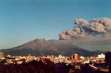
Repeated eruptions from the Sakurajima volcano have produced large amounts
of ash draping the city center Sept. 15, the Kagoshima Local Meteorological
Agency said. Eruptions from the volcano overlooking the city of Kagoshima
began on Wednesday morning, dumping 217 grams of ash per square meter (7
ounces per 10 square feet), the third-highest level of ash to fall since
records began in 1994. Volcanic ash covered much of Kagoshima's Tenmmonkan
entertainment and business district on Thursday morning, visibly forming
clouds as cars drove through it and many pedestrians covering their faces
with towels or surgical masks to avoid breathing it in.
WPAC: ROKE - Post-Tropical (18W)
Moderator: S2k Moderators
-
RobWESTPACWX
- WestPACMet

- Posts: 1616
- Joined: Fri Sep 17, 2010 2:26 am
- Location: Tokyo, Japan
- Contact:


Re: WPAC: ROKE - Tropical Storm (18W)
In the last hour or so, seems to have gained a lot of convection on radar. It is CALM here, right now, compared to yesterday. Bet you everyone and their brother is cursing the weather people here, right now, thinking the worst is over.
0 likes
-
StormingB81

- S2K Supporter

- Posts: 5676
- Age: 44
- Joined: Thu Aug 27, 2009 1:45 am
- Location: Rockledge, Florida
Re: WPAC: ROKE - Tropical Storm (18W)
Infdidoll wrote:In the last hour or so, seems to have gained a lot of convection on radar. It is CALM here, right now, compared to yesterday. Bet you everyone and their brother is cursing the weather people here, right now, thinking the worst is over.
this thing looks to be getting stronger bu the hour....I tell you what with a weak steering eviroment and this thing doing everything it wasnt forecasted to do..it could become a typhoon come west and be alot worst then everyone thought..I hope people have thier gaurds up until something happends whether it hits or turns away..
0 likes
-
RobWESTPACWX
- WestPACMet
- Posts: 1616
- Joined: Fri Sep 17, 2010 2:26 am
- Location: Tokyo, Japan
- Contact:
Re: WPAC: ROKE - Tropical Storm (18W)
Latest Vis imagery

0 likes
Satellites, Charts and Forecasting tools for East Asia at WESTERNPACIFICWEATHER.COM
-
RobWESTPACWX
- WestPACMet
- Posts: 1616
- Joined: Fri Sep 17, 2010 2:26 am
- Location: Tokyo, Japan
- Contact:
Re: WPAC: ROKE - Tropical Storm (18W)
JMA also starting to pick up on the turn NE on the 21st as the trough starts to pick it up, yet they have a very wide cone of error on it.


0 likes
Satellites, Charts and Forecasting tools for East Asia at WESTERNPACIFICWEATHER.COM
-
StormingB81
- S2K Supporter
- Posts: 5676
- Age: 44
- Joined: Thu Aug 27, 2009 1:45 am
- Location: Rockledge, Florida
-
RobWESTPACWX
- WestPACMet
- Posts: 1616
- Joined: Fri Sep 17, 2010 2:26 am
- Location: Tokyo, Japan
- Contact:
It very much does look like it is going to strengthen more than a weak TS.
One good thing that may inhibit it though is the fact it is stationary, that will cause a lot of upwelling and hopefully got off its latent heat intake. "fingers crossed"
One good thing that may inhibit it though is the fact it is stationary, that will cause a lot of upwelling and hopefully got off its latent heat intake. "fingers crossed"
0 likes
Satellites, Charts and Forecasting tools for East Asia at WESTERNPACIFICWEATHER.COM
-
StormingB81
- S2K Supporter
- Posts: 5676
- Age: 44
- Joined: Thu Aug 27, 2009 1:45 am
- Location: Rockledge, Florida
-
RobWESTPACWX
- WestPACMet
- Posts: 1616
- Joined: Fri Sep 17, 2010 2:26 am
- Location: Tokyo, Japan
- Contact:
I still don't think there is any need to go to any higher TCCORS ( I don't think Kadena will see winds above 50kts sustained) Thats at this time.., we all know how this storm has been, as long as people took there own initiative and stocked up and took everything in from outside all should be good.
But is that what your saying, no one really has prepared at all?
But is that what your saying, no one really has prepared at all?
0 likes
Satellites, Charts and Forecasting tools for East Asia at WESTERNPACIFICWEATHER.COM
-
StormingB81
- S2K Supporter
- Posts: 5676
- Age: 44
- Joined: Thu Aug 27, 2009 1:45 am
- Location: Rockledge, Florida
-
HurricaneBill
- Category 5

- Posts: 3419
- Joined: Sun Apr 11, 2004 5:51 pm
- Location: East Longmeadow, MA, USA
Re:
RobWESTPACWX wrote:Way off topic, yet something worth mentioning, southern Kyushu is getting the heavy rains, but also another volcano eruption there in the past 24hours, not the most wonderful day overall.
*****************************
Repeated eruptions from the Sakurajima volcano have produced large amounts
of ash draping the city center Sept. 15, the Kagoshima Local Meteorological
Agency said. Eruptions from the volcano overlooking the city of Kagoshima
began on Wednesday morning, dumping 217 grams of ash per square meter (7
ounces per 10 square feet), the third-highest level of ash to fall since
records began in 1994. Volcanic ash covered much of Kagoshima's Tenmmonkan
entertainment and business district on Thursday morning, visibly forming
clouds as cars drove through it and many pedestrians covering their faces
with towels or surgical masks to avoid breathing it in.
Sakurajima erupts practically everyday. It is one of Japan's most active and dangerous volcanoes.
0 likes
-
StormingB81
- S2K Supporter
- Posts: 5676
- Age: 44
- Joined: Thu Aug 27, 2009 1:45 am
- Location: Rockledge, Florida
-
RobWESTPACWX
- WestPACMet
- Posts: 1616
- Joined: Fri Sep 17, 2010 2:26 am
- Location: Tokyo, Japan
- Contact:
Ha, interesting Bill, I knew there was one down in Kyushu that was like that, should have put two and two together, just caught my eye today because I get email notifications about the Volcanoes and this one was in a similar area as the TS.
0 likes
Satellites, Charts and Forecasting tools for East Asia at WESTERNPACIFICWEATHER.COM


-
rdhdstpchld
- Tropical Depression

- Posts: 79
- Joined: Mon May 09, 2011 3:47 am
Re: WPAC: ROKE - Tropical Storm (18W)
I'm convinced it's taken another track b/c I actually got all my stuff tied down on Wed...LOL. It's like the forcefield is back up in effect...youth sports was cancelled, but it sure is a beautiful day out there - we had one band come thru with some driving rain around 8:30am, but that's it. It's breezy now, but minimal clouds. is there a ridge that is pushing this back away from Okinawa and north? Can anyone post the wind pattern graphic? thanks -
0 likes
-
RobWESTPACWX
- WestPACMet
- Posts: 1616
- Joined: Fri Sep 17, 2010 2:26 am
- Location: Tokyo, Japan
- Contact:
Re: WPAC: ROKE - Tropical Storm (18W)
Some very strong and severe rain bands starting to move on shore Shikoku now, JMA has put out a level 1 Tornado Threat on it.


0 likes
Satellites, Charts and Forecasting tools for East Asia at WESTERNPACIFICWEATHER.COM
-
RobWESTPACWX
- WestPACMet
- Posts: 1616
- Joined: Fri Sep 17, 2010 2:26 am
- Location: Tokyo, Japan
- Contact:
Re: WPAC: ROKE - Tropical Storm (18W)
rdhdstpchld wrote: Can anyone post the wind pattern graphic? thanks -
I think this is what your loooking for, not sure.
0 likes
Satellites, Charts and Forecasting tools for East Asia at WESTERNPACIFICWEATHER.COM


-
euro6208
Re: WPAC: ROKE - Tropical Storm (18W)
TXPQ29 KNES 162121
TCSWNP
A. 18W (ROKE)
B. 16/2101Z
C. 25.2N
D. 129.7E
E. THREE/MTSAT
F. T3.5/3.5/D1.0/24HRS
G. IR/EIR/SWIR/AMSRE
H. REMARKS...12-13 TENTHS BANDING ON LOG 10 SPIRAL YIELDS A DT OF
3.5. MET IS 3.0. PT IS 3.5. FT IS BASED ON PT.
I. ADDL POSITIONS
16/1716Z 25.6N 129.5E AMSRE
...NEWHARD
CI# /Pressure/ Vmax
3.1 / 989.9mb/ 47.0kt
Final T# Adj T# Raw T#
2.9 3.3 3.3
getting stronger by the hour
jtwc's forecast compared to other models...
0 likes
-
Typhoon Hunter
- WesternPacificWeather.com

- Posts: 1222
- Joined: Wed Oct 11, 2006 11:37 am
- Location: Tokyo
- Contact:
Re: WPAC: ROKE - Tropical Storm (18W)
JMA 5 day forecast looking ominous for Talas hit areas and is in line with latest ECMWF forecast too!
On a side note, Sakurajima is one of my favourite places in the world and hence I'm planning on heading back there to film. Hoping to catch Roke too if it passes nearby. Check out this shockwave and flying lava bomb I shot last time!
http://youtu.be/Gbrw2fWimeo
On a side note, Sakurajima is one of my favourite places in the world and hence I'm planning on heading back there to film. Hoping to catch Roke too if it passes nearby. Check out this shockwave and flying lava bomb I shot last time!
http://youtu.be/Gbrw2fWimeo
0 likes
Who is online
Users browsing this forum: No registered users and 14 guests