WPAC: ROKE - Post-Tropical (18W)

Moderator: S2k Moderators

Message
Author
euro6208

Re: WPAC: ROKE - Tropical Storm (18W)

#181 Postby euro6208 » Fri Sep 16, 2011 9:22 pm

Image

roke is so small and small storms tend to be much stronger than how they look and even dvorak estimates are low. i would place the intensity of roke at 60 knots.

The following post is NOT an official forecast and should not be used as such. It is just the opinion of the poster and may or may not be backed by sound meteorological data. It is NOT endorsed by any professional institution including storm2k.org. For official information, please refer to NWS products.
0 likes   

User avatar
Infdidoll
Category 2
Category 2
Posts: 667
Age: 47
Joined: Thu Oct 01, 2009 8:39 pm
Location: Temecula, CA

#182 Postby Infdidoll » Fri Sep 16, 2011 9:42 pm

I was just looking at the latest 1 km (zoomed) pic on the NRL site. Does this look like convective bursting going on? And doesn't that mean it could be rapidly intensifying?

Image
0 likes   

User avatar
Infdidoll
Category 2
Category 2
Posts: 667
Age: 47
Joined: Thu Oct 01, 2009 8:39 pm
Location: Temecula, CA

Re: WPAC: ROKE - Tropical Storm (18W)

#183 Postby Infdidoll » Fri Sep 16, 2011 9:47 pm

I may be totally wrong, but just thought I'd ask. Thought I read something about this a while back here and thought maybe someone could confirm or deny this. :wink:
0 likes   

euro6208

Re: WPAC: ROKE - Tropical Storm (18W)

#184 Postby euro6208 » Fri Sep 16, 2011 10:39 pm

TXPQ29 KNES 170321
TCSWNP

A. 18W (ROKE)

B. 17/0232Z

C. 25.3N

D. 129.8E

E. THREE/MTSAT

F. T4.0/4.0/D1.0/24HRS

G. IR/EIR/VIS/TMI/SSMIS

H. REMARKS...DT=4.0 BASED ON 1.1 BANDING ON LOG10
SPIRAL. PT-4.0. MET=4.0. RAGGED EYE APPARENT ON MICROWAVE AND VISIBLE
IMAGERY. FT IS BASED ON DT.

I. ADDL POSITIONS

16/2130Z 25.2N 129.9E TMI
16/2345Z 25.4N 130.0E SSMIS


...SCHWARTZ
0 likes   

User avatar
Macrocane
Category 5
Category 5
Posts: 4218
Age: 36
Joined: Sun May 24, 2009 5:35 pm
Location: El Salvador

Re: WPAC: ROKE - Tropical Storm (18W)

#185 Postby Macrocane » Fri Sep 16, 2011 10:51 pm

Roke and Sonca have a very nice structure (especially Sonka), they are one of the most symmetric little storms Ive ever seen.
0 likes   

rdhdstpchld
Tropical Depression
Tropical Depression
Posts: 79
Joined: Mon May 09, 2011 3:47 am

Re: WPAC: ROKE - Tropical Storm (18W)

#186 Postby rdhdstpchld » Sat Sep 17, 2011 12:00 am

RobWESTPACWX wrote:
rdhdstpchld wrote: Can anyone post the wind pattern graphic? thanks -


I think this is what your loooking for, not sure.

Image


Thanks Rob - I'm still learning -- :oops:
0 likes   

euro6208

Re: WPAC: ROKE - Tropical Storm (18W)

#187 Postby euro6208 » Sat Sep 17, 2011 12:03 am

Image

an eye is starting to take shape. at least 65 knots 1 minute winds. our eyes don't fool us.


The following post is NOT an official forecast and should not be used as such. It is just the opinion of the poster and may or may not be backed by sound meteorological data. It is NOT endorsed by any professional institution including storm2k.org. For official information, please refer to NWS products.
0 likes   

User avatar
StormingB81
S2K Supporter
S2K Supporter
Posts: 5676
Age: 43
Joined: Thu Aug 27, 2009 1:45 am
Location: Rockledge, Florida

#188 Postby StormingB81 » Sat Sep 17, 2011 1:14 am

I hope I dont wake up tomorrow morning with a storm over us...well one that is not forcasted to be over us!
0 likes   

User avatar
Extratropical94
Professional-Met
Professional-Met
Posts: 3538
Age: 30
Joined: Wed Oct 20, 2010 6:36 am
Location: Hamburg, Germany
Contact:

#189 Postby Extratropical94 » Sat Sep 17, 2011 4:23 am

WTPN31 PGTW 170900
MSGID/GENADMIN/NAVMARFCSTCEN PEARL HARBOR HI/JTWC//
SUBJ/TROPICAL CYCLONE WARNING//
RMKS/
1. TROPICAL STORM 18W (ROKE) WARNING NR 024
02 ACTIVE TROPICAL CYCLONES IN NORTHWESTPAC
MAX SUSTAINED WINDS BASED ON ONE-MINUTE AVERAGE
WIND RADII VALID OVER OPEN WATER ONLY
---
WARNING POSITION:
170600Z --- NEAR 25.0N 129.9E
MOVEMENT PAST SIX HOURS - 140 DEGREES AT 03 KTS
POSITION ACCURATE TO WITHIN 040 NM
POSITION BASED ON CENTER LOCATED BY A COMBINATION OF
SATELLITE AND RADAR
PRESENT WIND DISTRIBUTION:
MAX SUSTAINED WINDS - 055 KT, GUSTS 070 KT
WIND RADII VALID OVER OPEN WATER ONLY
RADIUS OF 050 KT WINDS - 020 NM NORTHEAST QUADRANT
020 NM SOUTHEAST QUADRANT
020 NM SOUTHWEST QUADRANT
020 NM NORTHWEST QUADRANT
RADIUS OF 034 KT WINDS - 110 NM NORTHEAST QUADRANT
110 NM SOUTHEAST QUADRANT
110 NM SOUTHWEST QUADRANT
100 NM NORTHWEST QUADRANT
REPEAT POSIT: 25.0N 129.9E
---
FORECASTS:
12 HRS, VALID AT:
171800Z --- 25.3N 130.1E
MAX SUSTAINED WINDS - 060 KT, GUSTS 075 KT
WIND RADII VALID OVER OPEN WATER ONLY
RADIUS OF 050 KT WINDS - 030 NM NORTHEAST QUADRANT
030 NM SOUTHEAST QUADRANT
030 NM SOUTHWEST QUADRANT
030 NM NORTHWEST QUADRANT
RADIUS OF 034 KT WINDS - 120 NM NORTHEAST QUADRANT
120 NM SOUTHEAST QUADRANT
115 NM SOUTHWEST QUADRANT
110 NM NORTHWEST QUADRANT
VECTOR TO 24 HR POSIT: 350 DEG/ 03 KTS
---
24 HRS, VALID AT:
180600Z --- 25.8N 130.0E
MAX SUSTAINED WINDS - 065 KT, GUSTS 080 KT
WIND RADII VALID OVER OPEN WATER ONLY
RADIUS OF 050 KT WINDS - 040 NM NORTHEAST QUADRANT
040 NM SOUTHEAST QUADRANT
035 NM SOUTHWEST QUADRANT
040 NM NORTHWEST QUADRANT
RADIUS OF 034 KT WINDS - 130 NM NORTHEAST QUADRANT
125 NM SOUTHEAST QUADRANT
120 NM SOUTHWEST QUADRANT
120 NM NORTHWEST QUADRANT
VECTOR TO 36 HR POSIT: 335 DEG/ 03 KTS
---
36 HRS, VALID AT:
181800Z --- 26.4N 129.7E
MAX SUSTAINED WINDS - 070 KT, GUSTS 085 KT
WIND RADII VALID OVER OPEN WATER ONLY
RADIUS OF 064 KT WINDS - 025 NM NORTHEAST QUADRANT
025 NM SOUTHEAST QUADRANT
025 NM SOUTHWEST QUADRANT
025 NM NORTHWEST QUADRANT
RADIUS OF 050 KT WINDS - 045 NM NORTHEAST QUADRANT
045 NM SOUTHEAST QUADRANT
045 NM SOUTHWEST QUADRANT
045 NM NORTHWEST QUADRANT
RADIUS OF 034 KT WINDS - 135 NM NORTHEAST QUADRANT
130 NM SOUTHEAST QUADRANT
130 NM SOUTHWEST QUADRANT
125 NM NORTHWEST QUADRANT
VECTOR TO 48 HR POSIT: 030 DEG/ 03 KTS
---
EXTENDED OUTLOOK:
48 HRS, VALID AT:
190600Z --- 27.0N 130.1E
MAX SUSTAINED WINDS - 070 KT, GUSTS 085 KT
WIND RADII VALID OVER OPEN WATER ONLY
RADIUS OF 064 KT WINDS - 025 NM NORTHEAST QUADRANT
025 NM SOUTHEAST QUADRANT
025 NM SOUTHWEST QUADRANT
025 NM NORTHWEST QUADRANT
RADIUS OF 050 KT WINDS - 045 NM NORTHEAST QUADRANT
045 NM SOUTHEAST QUADRANT
045 NM SOUTHWEST QUADRANT
045 NM NORTHWEST QUADRANT
RADIUS OF 034 KT WINDS - 130 NM NORTHEAST QUADRANT
135 NM SOUTHEAST QUADRANT
130 NM SOUTHWEST QUADRANT
125 NM NORTHWEST QUADRANT
VECTOR TO 72 HR POSIT: 050 DEG/ 04 KTS
---
72 HRS, VALID AT:
200600Z --- 28.0N 131.4E
MAX SUSTAINED WINDS - 065 KT, GUSTS 080 KT
WIND RADII VALID OVER OPEN WATER ONLY
RADIUS OF 064 KT WINDS - 020 NM NORTHEAST QUADRANT
020 NM SOUTHEAST QUADRANT
020 NM SOUTHWEST QUADRANT
020 NM NORTHWEST QUADRANT
RADIUS OF 050 KT WINDS - 040 NM NORTHEAST QUADRANT
040 NM SOUTHEAST QUADRANT
040 NM SOUTHWEST QUADRANT
040 NM NORTHWEST QUADRANT
RADIUS OF 034 KT WINDS - 125 NM NORTHEAST QUADRANT
125 NM SOUTHEAST QUADRANT
120 NM SOUTHWEST QUADRANT
115 NM NORTHWEST QUADRANT
VECTOR TO 96 HR POSIT: 045 DEG/ 12 KTS
---
LONG RANGE OUTLOOK:
---
96 HRS, VALID AT:
210600Z --- 31.2N 135.4E
MAX SUSTAINED WINDS - 060 KT, GUSTS 075 KT
WIND RADII VALID OVER OPEN WATER ONLY
BECOMING EXTRATROPICAL
VECTOR TO 120 HR POSIT: 040 DEG/ 21 KTS
---
120 HRS, VALID AT:
220600Z --- 37.1N 142.3E
MAX SUSTAINED WINDS - 050 KT, GUSTS 065 KT
WIND RADII VALID OVER OPEN WATER ONLY
BECOMING EXTRATROPICAL
---
REMARKS:
170900Z POSITION NEAR 25.1N 130.0E.
TROPICAL STORM (TS) 18W (ROKE), LOCATED APPROXIMATELY 145 NM
SOUTHEAST OF KADENA AB, JAPAN, HAS TRACKED SOUTHEASTWARD AT 03 KTS
OVER THE PAST SIX HOURS. ANIMATED MULTISPECTRAL SATELLITE IMAGERY
SHOWS INCREASED DEEP CONVECTION TIGHTLY WRAPPING INTO THE LOW LEVEL
CIRCULATION CENTER. THE INITIAL POSITION IS BASED ON A RADAR
REFLECTIVITY LOOP FROM OKINAWA. THE INITIAL INTENSITY IS BASED ON
DVORAK ESTIMATES FROM PGTW, RJTD AND KNES RANGING FROM 45 TO 65 KTS.
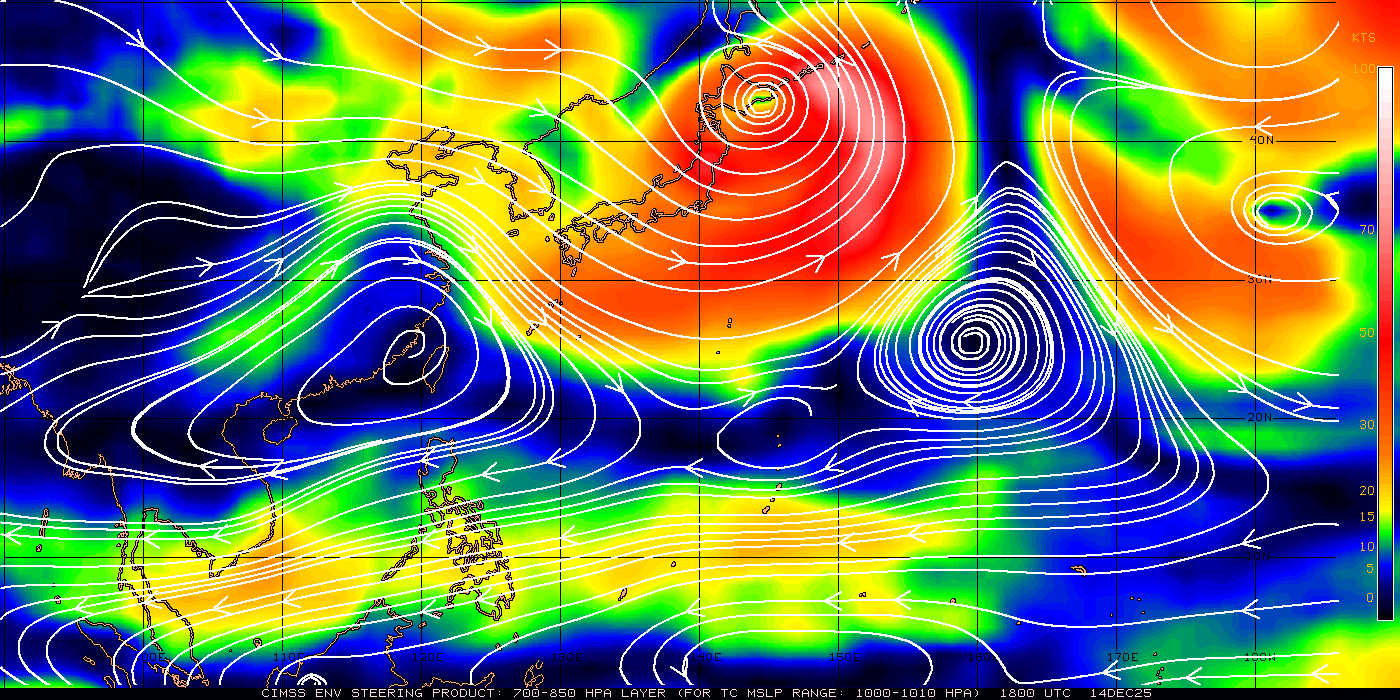
UPPER LEVEL ANALYSIS INDICATES THE SYSTEM IS TO THE SOUTH OF A RIDGE
AXIS IN AN AREA OF LIGHT (05-10 KT) VERTICAL WIND SHEAR (VWS).
ANIMATED WATER VAPOR IMAGERY SHOWS AN OUTFLOW CHANNEL HAS DEVELOPED
TO THE NORTHEAST AND EQUATORWARD OUTFLOW REMAINS ROBUST. TS 18W IS
CURRENTLY EMBEDDED IN A COL AREA BETWEEN TWO STEERING INFLUENCES - A
SUBTROPICAL RIDGE (STR) EXTENDING FROM CENTRAL EASTERN CHINA AND A
DEEP-LAYERED STR EAST OF JAPAN. RECENT STORM MOTION SUGGESTS THE
RIDGE EAST OF JAPAN HAS, FOR THE MOMENT, REGAINED CONTROL OF THE
SYSTEM. TS 18W IS EXPECTED TO MEANDER WEAKLY IN THE COL AREA OVER
THE NEXT 48 HOURS BEFORE TURNING NORTHEASTWARD AND BEGINNING EXTRA-
TROPICAL TRANSITION. IT IS EXPECTED TO SLOWLY INTENSIFY OVER THE
NEXT 3 DAYS DUE TO GOOD OUTFLOW, LOW VWS, AND HIGH SEA SURFACE
TEMPERATURES. THE AVAILABLE NUMERICAL MODEL GUIDANCE IS IN GOOD
AGREEMENT WITH THE EVENTUAL RECURVATURE TO THE NORTHEAST BUT SHOW
DIFFERENT DIRECTIONS OF LOOPING NORTHWARD. MAXIMUM SIGNIFICANT WAVE
HEIGHT AT 170600Z IS 16 FEET. NEXT WARNINGS AT 171500Z, 172100Z,
180300Z AND 180900Z. REFER TO TROPICAL STORM 19W (SONCA) WARNINGS
(WTPN32 PGTW) FOR SIX-HOURLY UPDATES.//
NNNN
0 likes   
54° 11' 59'' N, 9° 9' 20'' E
Boomer Sooner!
Go Broncos! Go Cards! Go Niners!
- Daniel

User avatar
StormingB81
S2K Supporter
S2K Supporter
Posts: 5676
Age: 43
Joined: Thu Aug 27, 2009 1:45 am
Location: Rockledge, Florida

#190 Postby StormingB81 » Sat Sep 17, 2011 4:29 am

Sooo...JMA has it coming just off the coast of Okinawa....ECMWF has it hitting us....JTWC has it not commign any closer who will be right..and we are still in TCCOR 3..
0 likes   

User avatar
Infdidoll
Category 2
Category 2
Posts: 667
Age: 47
Joined: Thu Oct 01, 2009 8:39 pm
Location: Temecula, CA

Re: WPAC: ROKE - Tropical Storm (18W)

#191 Postby Infdidoll » Sat Sep 17, 2011 4:38 am

JMA hasn't issued a new update, I don't think...that track still looks the same as it did earlier. ECMWF still keeps it offshore. JTWC has it missing us by a longshot...It does seem to be moving away from us. Darn, right? :cry:

It's okay, looks like the next typhoon may be along next week if ECMWF is correct.
0 likes   

User avatar
StormingB81
S2K Supporter
S2K Supporter
Posts: 5676
Age: 43
Joined: Thu Aug 27, 2009 1:45 am
Location: Rockledge, Florida

Re: WPAC: ROKE - Tropical Storm (18W)

#192 Postby StormingB81 » Sat Sep 17, 2011 4:40 am

Infdidoll wrote:JMA hasn't issued a new update, I don't think...that track still looks the same as it did earlier. ECMWF still keeps it offshore. JTWC has it missing us by a longshot...It does seem to be moving away from us. Darn, right? :cry:

It's okay, looks like the next typhoon may be along next week if ECMWF is correct.


I know I was talking about the old track which brings it close....but ECMWF and JMA are close together in agreeance..JTWC is way east of thier tracks
0 likes   

User avatar
StormingB81
S2K Supporter
S2K Supporter
Posts: 5676
Age: 43
Joined: Thu Aug 27, 2009 1:45 am
Location: Rockledge, Florida

#193 Postby StormingB81 » Sat Sep 17, 2011 4:47 am

JMA update just happend..moved southwest..lol drunken storm..JMA still says it will come very close..who knows anymore what this thing whats to do!
0 likes   

phwxenthusiast
Category 2
Category 2
Posts: 637
Joined: Wed Mar 24, 2010 3:10 am
Location: Holbrook, NY (Long Island)

#194 Postby phwxenthusiast » Sat Sep 17, 2011 5:08 am

i don't think it'll hit either but it could be close enough to bring TS-force winds starting tomorrow, in addition to rain and strong waves... Amami-Oshima will probably see stronger winds... then of course after that, all eyes will be in Honshu...

anyway looking at Roke, it looks like an eyewall might be near completion.. convection looking good as always, prolly a TY by tomorrow morning (Asia time)

Image

The posts in this forum are NOT official forecast and should not be used as such. They are just the opinion of the poster and may or may not be backed by sound meteorological data. They are NOT endorsed by any professional institution or storm2k.org. For official information, please refer to the JTWC and JMA products.
0 likes   

User avatar
StormingB81
S2K Supporter
S2K Supporter
Posts: 5676
Age: 43
Joined: Thu Aug 27, 2009 1:45 am
Location: Rockledge, Florida

#195 Postby StormingB81 » Sat Sep 17, 2011 5:12 am

I know one thing..I dont think I will ever see a track like this again....def a drunken typhoon...so who knows..I have never seen anything like this with a typhoon being this unpredictable in not following the forecast
0 likes   

User avatar
StormingB81
S2K Supporter
S2K Supporter
Posts: 5676
Age: 43
Joined: Thu Aug 27, 2009 1:45 am
Location: Rockledge, Florida

#196 Postby StormingB81 » Sat Sep 17, 2011 5:27 am

http://www.wunderground.com/tropical/tr ... 8_sat.html

Storm look like it is growing or expanding to anyone?
0 likes   

dexterlabio
Category 5
Category 5
Posts: 3468
Joined: Sat Oct 24, 2009 11:50 pm

Re: WPAC: ROKE - Tropical Storm (18W)

#197 Postby dexterlabio » Sat Sep 17, 2011 5:45 am

I think it is doing a loop and after that the major track will be towards Honshu, there is a weak steering environment over Roke but that coming trough and maybe that somewhat "anticyclonic" turning over Mindanao are going to introduce a more northeasterly movement in the coming days. That being said, it will be critical to determine if there will be any wobble to the west and how long those wobbles will take place because that will tell the fate of Okinawa.

Crazy setup I would say, something that forecasters have least hoped for. Maybe the same scenario with STY Lupit in 2009?

Image

I guess this storm is already causing the thrill among our folks in Okinawa. :lol:


Personal Forecast Disclaimer:
The posts in this forum are NOT official forecast and should not be used as such. They are just the opinion of the poster and may or may not be backed by sound meteorological data. They are NOT endorsed by any professional institution or storm2k.org. For official information, please refer to the NHC and NWS products.
0 likes   
Personal Forecast Disclaimer:
The posts in this forum are NOT official forecast and should not be used as such. They are just the opinion of the poster and may or may not be backed by sound meteorological data. They are NOT endorsed by any professional institution or storm2k.org. For official information, please refer to the NHC and NWS products.

User avatar
StormingB81
S2K Supporter
S2K Supporter
Posts: 5676
Age: 43
Joined: Thu Aug 27, 2009 1:45 am
Location: Rockledge, Florida

#198 Postby StormingB81 » Sat Sep 17, 2011 5:48 am

Well besides a good rain at 830 its been a great day out...lol but who knows..this could wobble west for awhile and we could have fun..radar here shows it moving west the last hour ever so slowly
0 likes   

User avatar
Infdidoll
Category 2
Category 2
Posts: 667
Age: 47
Joined: Thu Oct 01, 2009 8:39 pm
Location: Temecula, CA

Re: WPAC: ROKE - Tropical Storm (18W)

#199 Postby Infdidoll » Sat Sep 17, 2011 6:25 am

I think they're starting to get angry and cursing the weather folks again because there were a few festivals, concerts, etc. that were postponed and cancelled. We've had just about all the good festivals cancelled this year because of inclement weather every other weekend!
0 likes   

User avatar
StormingB81
S2K Supporter
S2K Supporter
Posts: 5676
Age: 43
Joined: Thu Aug 27, 2009 1:45 am
Location: Rockledge, Florida

Re: WPAC: ROKE - Tropical Storm (18W)

#200 Postby StormingB81 » Sat Sep 17, 2011 6:40 am

Infdidoll wrote:I think they're starting to get angry and cursing the weather folks again because there were a few festivals, concerts, etc. that were postponed and cancelled. We've had just about all the good festivals cancelled this year because of inclement weather every other weekend!


alot of drowning pool fans where mad...lol...but its not over yet this one is drunk and unpredictable...it can still give us a hit....some were joking saying that its supposed to be like this that it is waiting for monday so we can have some days off...lol
0 likes   


Return to “2011”

Who is online

Users browsing this forum: No registered users and 1 guest