
Hard to say, but probably the reason it is not going to get a name is because it's impossible to separate what winds are being caused by the low itself, and what winds are coming from the pressure gradient set-up. You don't have to read very far between the lines to see that they feel like most winds are from the gradient, not the low itself. Winds in the absense of precipitation bands indicate to me that most of these winds are not solely from the low, but from the tight gradient. Absence of westerlies add to this argument.
It's not too uncommon, just usually happens further north. We had winds here in march of 93 that topped hurricane force, from a similar set-up. It's just a strong nor'easter right now, and probably will remain so.
With that being said, be careful out there. Nor'easters can be much more destructive than hurricanes.
ATL: INVEST 93L - Discussion
Moderator: S2k Moderators
Re: ATL: INVEST 93L - Discussion
0 likes
Ginger-(eye),Dennis,Diana,Kate,Gloria,Charley-(eye),Allison,Arthur,Bertha,Fran,Josephine,Bonnie,Earl,Dennis-(twice),Floyd, Isabel-(eye),Charley,Ophelia-(eyewall),Ernesto,Barry,Hanna,Irene-(eye),Arthur-(eye), Florence, Dorian, and countless depressions, storms, and nor'easters.
-
brunota2003

- S2K Supporter

- Posts: 9476
- Age: 35
- Joined: Sat Jul 30, 2005 9:56 pm
- Location: Stanton, KY...formerly Havelock, NC
- Contact:
Re: ATL: INVEST 93L - Discussion
capepoint wrote:Hard to say, but probably the reason it is not going to get a name is because it's impossible to separate what winds are being caused by the low itself, and what winds are coming from the pressure gradient set-up. You don't have to read very far between the lines to see that they feel like most winds are from the gradient, not the low itself. Winds in the absense of precipitation bands indicate to me that most of these winds are not solely from the low, but from the tight gradient. Absence of westerlies add to this argument.
It's not too uncommon, just usually happens further north. We had winds here in march of 93 that topped hurricane force, from a similar set-up. It's just a strong nor'easter right now, and probably will remain so.
With that being said, be careful out there. Nor'easters can be much more destructive than hurricanes.
I second this...we saw quite a few Nor'easters in the March time frame, over my years of living in NC, that produced strong winds in the low 40s with gusts in the upper 50s/lower 60s. They cause more damage than you think, especially when they spring up out of nowhere and no one is ready! Also, another reason I think they might not be upgrading is that there are plenty of N/NE winds, and even a few reports of E winds...but I have yet to see anything beyond that.
Buoy 41009 is reporting sustained winds of 47 mph, with gusts to 62.6 mph. Pressure is 29.63" or 1003.4 millibars.
0 likes
-
cycloneye

- Admin

- Posts: 149364
- Age: 69
- Joined: Thu Oct 10, 2002 10:54 am
- Location: San Juan, Puerto Rico
Re: ATL: INVEST 93L - Discussion
cycloneye wrote:00z Best Track
Up to 40kts and pressure down to 1005 mbs.
AL, 93, 2011101000, , BEST, 0, 280N, 800W, 40, 1005, SS
ftp://ftp.tpc.ncep.noaa.gov/atcf/tcweb/ ... 011.invest
Best Track and SSD dvorak agree on Subtropical classification by the 2.5 T number given that is in line with what BT has on the wind intensity.
09/2345 UTC 28.4N 80.2W ST2.5 93L -- Atlantic
0 likes
Visit the Caribbean-Central America Weather Thread where you can find at first post web cams,radars
and observations from Caribbean basin members Click Here
and observations from Caribbean basin members Click Here
Re: ATL: INVEST 93L - Discussion
cycloneye wrote:00z Best Track
Up to 40kts and pressure down to 1005 mbs.
AL, 93, 2011101000, , BEST, 0, 280N, 800W, 40, 1005, SS
ftp://ftp.tpc.ncep.noaa.gov/atcf/tcweb/ ... 011.invest
Actual lowest pressures are lower than 1,005 mb because the SLP at a buoy 50 miles E of Cape Canaveral has dropped sharply to 1,003.4 mb!
0 likes
Personal Forecast Disclaimer:
The posts in this forum are NOT official forecasts and should not be used as such. They are just the opinion of the poster and may or may not be backed by sound meteorological data. They are NOT endorsed by any professional institution or storm2k.org. For official information, please refer to the NHC and NWS products.
The posts in this forum are NOT official forecasts and should not be used as such. They are just the opinion of the poster and may or may not be backed by sound meteorological data. They are NOT endorsed by any professional institution or storm2k.org. For official information, please refer to the NHC and NWS products.
Pressures are sig. lower than were progged by all model runs except, interestingly enough, those THU/FRI GFS runs I posted showing a pretty well organized low moving NNW not far from where the low is now. The lowest pressure on those THU/FRI runs was 1,003 mb (and 1,000 mb on a Wed. run as it headed further NNW toward GA). The lowest is now down at least as low as 1,003 mb and is moving either NW or NNW! It will be interesting to see how this evolves. At the very least, it appears to me that the GFS, which was mostly on its own with its E of FL pretty well organized sfc low, is suddenly looking like a guru!!
Check out the conditions at a buoy at 28.5 N, 80.2 W, which is ~50 miles E of Cape Canaveral **note the 3.4 mb/0.10" fall in pressure during just the last hour!** Also, note the 4 F temp. rise from 73 F to 77 F. Also, note the SST of 82 F there...plenty warm enough to allow for tropical development:
STATION/POSITION TEMP WIND PRES WAVE SWELL
AIR SEA DIR/SP/G HT/PER HT/PER (F) (DEG/KT/KT) (MB) (FT/S) (FT/S)
6 PM 28.5N 80.2W 74 82 10/ 31/ 39 1008.6F 20/12 16/12
7 PM 28.5N 80.2W 73 82 10/ 39/ 47 1006.8F 19/11 15/11
8 PM 28.5N 80.2W 77 82 20/ 41/ 54 1003.4F 22/11 18/11
Last edited by LarryWx on Sun Oct 09, 2011 7:46 pm, edited 1 time in total.
0 likes
Personal Forecast Disclaimer:
The posts in this forum are NOT official forecasts and should not be used as such. They are just the opinion of the poster and may or may not be backed by sound meteorological data. They are NOT endorsed by any professional institution or storm2k.org. For official information, please refer to the NHC and NWS products.
The posts in this forum are NOT official forecasts and should not be used as such. They are just the opinion of the poster and may or may not be backed by sound meteorological data. They are NOT endorsed by any professional institution or storm2k.org. For official information, please refer to the NHC and NWS products.
-
Rainband
Re: ATL: INVEST 93L - Discussion
there is still a circulation in the GOM off ft myers. Near the trof axis that spawned 93L.
0 likes
-
AdamFirst

- S2K Supporter
- Posts: 2490
- Age: 36
- Joined: Thu Aug 14, 2008 10:54 am
- Location: Port Saint Lucie, FL
It's a very still, clear night here in Port Saint Lucie now. Heck of a lightning show to our north.
0 likes
Dolphins Marlins Canes Golden Panthers HEAT
Andrew 1992 - Irene 1999 - Frances 2004 - Jeanne 2004 - Wilma 2005 - Fay 2008 - Isaac 2012 - Matthew 2016 - Irma 2017 - Dorian 2019 - Ian 2022 - Nicole 2022 - Milton 2024
Andrew 1992 - Irene 1999 - Frances 2004 - Jeanne 2004 - Wilma 2005 - Fay 2008 - Isaac 2012 - Matthew 2016 - Irma 2017 - Dorian 2019 - Ian 2022 - Nicole 2022 - Milton 2024
-
cycloneye
- Admin
- Posts: 149364
- Age: 69
- Joined: Thu Oct 10, 2002 10:54 am
- Location: San Juan, Puerto Rico
Re: ATL: INVEST 93L - Discussion
Rainband wrote:didn't you just post that? Am I seeing double
I quoted Best Track with the post of SSD dvorak numbers.
0 likes
Visit the Caribbean-Central America Weather Thread where you can find at first post web cams,radars
and observations from Caribbean basin members Click Here
and observations from Caribbean basin members Click Here
-
Rainband
Re: ATL: INVEST 93L - Discussion
my bad luis. Long daycycloneye wrote:Rainband wrote:didn't you just post that? Am I seeing double
I quoted Best Track with the post of SSD dvorak numbers.
0 likes
-
brunota2003
- S2K Supporter
- Posts: 9476
- Age: 35
- Joined: Sat Jul 30, 2005 9:56 pm
- Location: Stanton, KY...formerly Havelock, NC
- Contact:
Re: ATL: INVEST 93L - Discussion
brunota2003 wrote:capepoint wrote:Hard to say, but probably the reason it is not going to get a name is because it's impossible to separate what winds are being caused by the low itself, and what winds are coming from the pressure gradient set-up. You don't have to read very far between the lines to see that they feel like most winds are from the gradient, not the low itself. Winds in the absense of precipitation bands indicate to me that most of these winds are not solely from the low, but from the tight gradient. Absence of westerlies add to this argument.
It's not too uncommon, just usually happens further north. We had winds here in march of 93 that topped hurricane force, from a similar set-up. It's just a strong nor'easter right now, and probably will remain so.
With that being said, be careful out there. Nor'easters can be much more destructive than hurricanes.
I second this...we saw quite a few Nor'easters in the March time frame, over my years of living in NC, that produced strong winds in the low 40s with gusts in the upper 50s/lower 60s. They cause more damage than you think, especially when they spring up out of nowhere and no one is ready! Also, another reason I think they might not be upgrading is that there are plenty of N/NE winds, and even a few reports of E winds...but I have yet to see anything beyond that.
Buoy 41009 is reporting sustained winds of 47 mph, with gusts to 62.6 mph. Pressure is 29.63" or 1003.4 millibars.
Plus, look at the air temps. upper 60's and low 70's. Not tropical.
0 likes
Ginger-(eye),Dennis,Diana,Kate,Gloria,Charley-(eye),Allison,Arthur,Bertha,Fran,Josephine,Bonnie,Earl,Dennis-(twice),Floyd, Isabel-(eye),Charley,Ophelia-(eyewall),Ernesto,Barry,Hanna,Irene-(eye),Arthur-(eye), Florence, Dorian, and countless depressions, storms, and nor'easters.


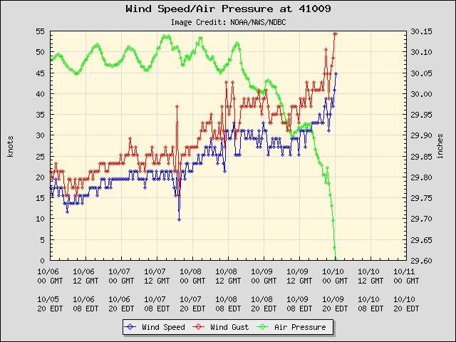
Buoy 41009 now reporting a pressure of 1002 mb! This has tropical charecteristics!
http://www.ndbc.noaa.gov/station_page.php?station=41009
Conditions at 41009 as of
(8:20 pm EDT on 10/09/2011)
0020 GMT on 10/10/2011:
Wind Direction (WDIR): NNE ( 30 deg true )
Wind Speed (WSPD): 44.7 kts
Wind Gust (GST): 54.4 kts
Atmospheric Pressure (PRES): 29.60 in
Air Temperature (ATMP): 78.4 °F
Water Temperature (WTMP): 81.7 °F
Dew Point (DEWP): 74.5 °F
Heat Index (HEAT): 81.5 °F
http://www.ndbc.noaa.gov/station_page.php?station=41009
0 likes
-
brunota2003
- S2K Supporter
- Posts: 9476
- Age: 35
- Joined: Sat Jul 30, 2005 9:56 pm
- Location: Stanton, KY...formerly Havelock, NC
- Contact:
Re:
RL3AO wrote:Joe Bastardi
respectfully disagree with TPC. Data buoy pressure is down 4 mb in 2 hours with gusts of 55-60. This is a tight system over warm water
Make that 5 mb drop in 2 hrs, almost 8 mb in 3 hrs!
And look at the winds.
0 likes
-
brunota2003
- S2K Supporter
- Posts: 9476
- Age: 35
- Joined: Sat Jul 30, 2005 9:56 pm
- Location: Stanton, KY...formerly Havelock, NC
- Contact:
We'll see, as it passes by, what kind of a wind shift we get at the buoy...whether there is little to none, or if it is a sharp shift. My bet, just looking at the obs from the areas, leans toward little to none.
Correction:
There are finally NW winds showing up on local coastal obs...Melbourne is NW. How sharp is the shift, though?
Correction:
There are finally NW winds showing up on local coastal obs...Melbourne is NW. How sharp is the shift, though?
Last edited by brunota2003 on Sun Oct 09, 2011 8:14 pm, edited 1 time in total.
0 likes


Re: Re:
AJC3 wrote:chris_fit wrote:I don't understand why this isn't named already. NHC has named storms that looked tons worse than this.
Clearly we had development of a LCC this afternoon... The winds are there TS force, and it's right next to land. Take a look at the buoys offshore for wind readings. I'm by i-95 in Brevard County and I would say it's gusting to 35-40mph already.
I mean really? Look at this on Radar...
http://radar.weather.gov/radar.php?rid= ... 1&loop=yes
You probably don't realize what a logistical nightmare this would cause our office to name this thing at such a late hour. We would have to cancel the Gale Warning, High Surf Advisory, Wind Advisory and Lake Wind Advisory that have been up now for two days and replace them with Subtropical Storm Warning. We would need to put out products cancelling the current advisories, and then issue a Subtropical Storm Local Statement, update the Zone Forecasts, Coastal Waters Forecast Hazardous Weather Outlook, our blog and Short term Forecast. Local graphics would have to be updated as well as our forecast grids.
All this for a low center that will be moving inland shortly.
All this to describe sensible weather conditions that have been well-handled by the current suite of products.
To name this thing would be counter-productive and create a bunch of duplicative work.
Something to think about before we start calling out folks within our agency.
Thank you for posting this Tony!
We (well at least "I") really don't know the ramifications of things like naming a storm and the effect that it has on you guys at the local offices.
And for a system that isn't about to ramp up to something more than what you have produced products for.
Wow, a totally different perspective!!!!
Appreciate it.
0 likes
down to 1000.6 mb now at the buoy!!!!!! 3 mb down in last hour!!!! Uh oh!
STATION/POSITION TEMP WIND PRES WAVE SWELL
AIR SEA DIR/SP/G HT/PER HT/PER
(F) (DEG/KT/KT) (MB) (FT/S) (FT/S)
28.5N 80.2W 78 82 30/ 45/ 54 1000.6F
STATION/POSITION TEMP WIND PRES WAVE SWELL
AIR SEA DIR/SP/G HT/PER HT/PER
(F) (DEG/KT/KT) (MB) (FT/S) (FT/S)
28.5N 80.2W 78 82 30/ 45/ 54 1000.6F
Last edited by LarryWx on Sun Oct 09, 2011 8:15 pm, edited 1 time in total.
0 likes
Personal Forecast Disclaimer:
The posts in this forum are NOT official forecasts and should not be used as such. They are just the opinion of the poster and may or may not be backed by sound meteorological data. They are NOT endorsed by any professional institution or storm2k.org. For official information, please refer to the NHC and NWS products.
The posts in this forum are NOT official forecasts and should not be used as such. They are just the opinion of the poster and may or may not be backed by sound meteorological data. They are NOT endorsed by any professional institution or storm2k.org. For official information, please refer to the NHC and NWS products.
Who is online
Users browsing this forum: No registered users and 25 guests