TROPICAL STORM RINA DISCUSSION NUMBER 3
NWS NATIONAL HURRICANE CENTER MIAMI FL AL182011
500 AM EDT MON OCT 24 2011
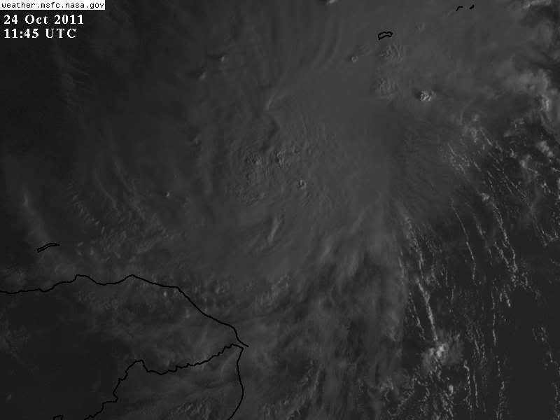
THE CLOUD PATTERN OF RINA HAS NOT BECOME BETTER ORGANIZED OVER THE
PAST SEVERAL HOURS. THERE IS ONE LARGE CLUSTER OF DEEP CONVECTION
JUST TO THE NORTH OF THE ESTIMATED CENTER POSITION WITH A COUPLE OF
ADJACENT SMALLER CLUSTERS...BUT NOT MUCH EVIDENCE OF CURVED BANDS.
VERY LITTLE THUNDERSTORM ACTIVITY IS CURRENTLY OCCURRING OVER THE
SOUTHERN HALF OF THE CIRCULATION. THE INITIAL WIND SPEED IS HELD AT
35 KT IN AGREEMENT WITH THE LATEST OBJECTIVE DVORAK INTENSITY
ESTIMATES FROM UW/CIMSS. RINA IS IN AN ENVIRONMENT OF MODERATE
SOUTH-SOUTHEASTERLY VERTICAL BUT IS EXHIBITING FAIRLY WELL-DEFINED
UPPER-LEVEL OUTFLOW OVER ALL BUT THE SOUTHEASTERN QUADRANT OF THE
CIRCULATION. THE SHIPS GUIDANCE INDICATES THAT A SLIGHT LESSENING
OF THE SHEAR COULD OCCUR IN THE NEXT COUPLE OF DAYS. TOTAL
PRECIPITABLE WATER IMAGERY ALONG WITH SURFACE AND RADIOSONDE DATA
SHOW A SIGNIFICANTLY DRIER LOW- TO MID-TROPOSPHERIC AIR MASS EXISTS
JUST TO THE NORTH AND WEST OF THE STORM. GIVEN THESE MARGINALLY
CONDUCIVE ENVIRONMENTAL FACTORS...ONLY SLOW STRENGTHENING IS
FORECAST. THE OFFICIAL INTENSITY FORECAST IS VERY SIMILAR TO THE
LGEM GUIDANCE AND BELOW THE GFDL AND HWRF MODELS.
USING A COMBINATION OF CENTER FIXES FROM GEOSTATIONARY AND MICROWAVE
IMAGERY YIELDS AN INITIAL MOTION ESTIMATE OF 330/5. A 500 MB SHORT
WAVE TROUGH IS CURRENTLY PASSING TO THE NORTH AND WILL SOON BYPASS
THE TROPICAL CYCLONE. AFTER THE TROUGH DEPARTS THE AREA...A WEAK
RIDGE IS FORECAST TO DEVELOP TO THE NORTH OF RINA. THIS STEERING
PATTERN SHOULD CAUSE THE CYCLONE TO TURN TOWARD THE WEST...BUT AT A
VERY SLOW RATE OF FORWARD SPEED...DURING THE NEXT 48 HOURS. BY THE
END OF THE FORECAST PERIOD A STRONGER TROUGH MOVES INTO THE EASTERN
UNITED STATES...WHICH SHOULD INDUCE A NORTHWARD TURN. THE OFFICIAL
TRACK FORECAST IS CLOSE TO A CONSENSUS OF THE GLOBAL MODELS...WHICH
ARE WELL TO THE SOUTH AND WEST OF THE GFDL AND HWRF. THESE LATTER
MODELS ARE PREDICTING RINA TO BECOME A STRONG HURRICANE THAT WOULD
RESPOND TO THE DEEP-LAYER SOUTHWESTERLY FLOW OVER THE EASTERN GULF.
GIVEN THE PREDICTED ATMOSPHERIC ENVIRONMENT...SUCH A SCENARIO SEEMS
UNLIKELY AT THIS TIME.
FORECAST POSITIONS AND MAX WINDS
INIT 24/0900Z 16.7N 82.3W 35 KT 40 MPH
12H 24/1800Z 17.0N 82.9W 40 KT 45 MPH
24H 25/0600Z 17.4N 83.6W 45 KT 50 MPH
36H 25/1800Z 17.5N 84.3W 50 KT 60 MPH
48H 26/0600Z 17.6N 85.0W 55 KT 65 MPH
72H 27/0600Z 18.5N 86.5W 60 KT 70 MPH
96H 28/0600Z 19.5N 87.0W 65 KT 75 MPH
120H 29/0600Z 20.5N 87.0W 65 KT 75 MPH
$$
FORECASTER PASCH/LANDSEA
ATL: RINA - Post-Tropical - Discussion
Moderator: S2k Moderators
-
cycloneye

- Admin

- Posts: 149345
- Age: 69
- Joined: Thu Oct 10, 2002 10:54 am
- Location: San Juan, Puerto Rico
Re: ATL: RINA - Advisories
0 likes
Visit the Caribbean-Central America Weather Thread where you can find at first post web cams,radars
and observations from Caribbean basin members Click Here
and observations from Caribbean basin members Click Here
-
Florida1118
Re: ATL: RINA - Tropical Storm - Discussion
Looking good imo. Im going to say this becomes a Hurricane in 3 days and goes onshore the Yucatan Penninsula, then moves as a very sheared mess into South Florida, similar to Paula last year, except bigger. The damage to the YP will be mild with little damage to Cuba, and then again mild damage to South Florida. I say it maxes out at 90mph...and this is just my own personal guesses. Imma thinking she'll be up to at least 50mph by tonight...
Personal Forecast Disclaimer:
The posts in this forum are NOT official forecast and should not be used as such. They are just the opinion of the poster and may or may not be backed by sound meteorological data. They are NOT endorsed by any professional institution or storm2k.org. For official information, please refer to the NHC and NWS products
0 likes

Re: ATL: RINA - Tropical Storm - Discussion
Poleward outflow channel has kicked in big time.
No vorticity at 200mb. Looks like a classic west Carib spin-up underway.


No vorticity at 200mb. Looks like a classic west Carib spin-up underway.
0 likes
-
cycloneye
- Admin
- Posts: 149345
- Age: 69
- Joined: Thu Oct 10, 2002 10:54 am
- Location: San Juan, Puerto Rico
Re: ATL: RINA - Tropical Storm - Discussion
For those who may inquire about when is the next recon,it departs around 10:45 AM EDT from Keesler base.
FLIGHT ONE -- TEAL 71
A. 24/1800Z
B. AFXXX 0218A CYCLONE
C. 24/1445Z
D. 16.6N 82.4W
E. 24/1730Z TO 24/2100Z
F. SFC TO 10,000 FT
FLIGHT ONE -- TEAL 71
A. 24/1800Z
B. AFXXX 0218A CYCLONE
C. 24/1445Z
D. 16.6N 82.4W
E. 24/1730Z TO 24/2100Z
F. SFC TO 10,000 FT
0 likes
Visit the Caribbean-Central America Weather Thread where you can find at first post web cams,radars
and observations from Caribbean basin members Click Here
and observations from Caribbean basin members Click Here
-
cycloneye
- Admin
- Posts: 149345
- Age: 69
- Joined: Thu Oct 10, 2002 10:54 am
- Location: San Juan, Puerto Rico
Re: ATL: RINA - Advisories
BULLETIN
TROPICAL STORM RINA INTERMEDIATE ADVISORY NUMBER 3A
NWS NATIONAL HURRICANE CENTER MIAMI FL AL182011
800 AM EDT MON OCT 24 2011
...RINA MOVING SLOWLY NORTH-NORTHWESTWARD...
SUMMARY OF 800 AM EDT...1200 UTC...INFORMATION
----------------------------------------------
LOCATION...16.8N 82.5W
ABOUT 135 MI...215 KM NNE OF CABO GRACIAS A DIOS ON NIC/HON BORDER
ABOUT 195 MI...310 KM SSW OF GRAND CAYMAN
MAXIMUM SUSTAINED WINDS...40 MPH...65 KM/H
PRESENT MOVEMENT...NNW OR 330 DEGREES AT 6 MPH...9 KM/H
MINIMUM CENTRAL PRESSURE...1003 MB...29.62 INCHES
WATCHES AND WARNINGS
--------------------
CHANGES WITH THIS ADVISORY...
NONE.
SUMMARY OF WATCHES AND WARNINGS IN EFFECT...
A TROPICAL STORM WATCH IS IN EFFECT FOR...
* THE COAST OF HONDURAS FROM PUNTA CASTILLA EASTWARD TO THE
NICARAGUAN BORDER
A TROPICAL STORM WATCH MEANS THAT TROPICAL STORM CONDITIONS ARE
POSSIBLE WITHIN THE WATCH AREA...GENERALLY WITHIN 48 HOURS.
FOR STORM INFORMATION SPECIFIC TO YOUR AREA...PLEASE MONITOR
PRODUCTS ISSUED BY YOUR NATIONAL METEOROLOGICAL SERVICE.
DISCUSSION AND 48-HOUR OUTLOOK
------------------------------
AT 800 AM EDT...1200 UTC...THE CENTER OF TROPICAL STORM RINA WAS
LOCATED NEAR LATITUDE 16.8 NORTH...LONGITUDE 82.5 WEST. RINA IS
MOVING TOWARD THE NORTH-NORTHWEST NEAR 6 MPH...9 KM/H...AND A
GRADUAL TURN TOWARD THE WEST IS EXPECTED OVER THE NEXT 48 HOURS.
ON THE FORECAST TRACK...THE CENTER OF RINA IS EXPECTED TO PASS
NORTH OF THE NORTHEASTERN COAST OF HONDURAS DURING THE NEXT COUPLE
OF DAYS.
MAXIMUM SUSTAINED WINDS ARE NEAR 40 MPH...65 KM/H...WITH HIGHER
GUSTS. SOME STRENGTHENING IS FORECAST DURING THE NEXT 48 HOURS.
TROPICAL STORM FORCE WINDS EXTEND OUTWARD UP TO 90 MILES...150
KM...MAINLY TO THE NORTH AND WEST OF THE CENTER.
ESTIMATED MINIMUM CENTRAL PRESSURE IS 1003 MB...29.62 INCHES.
HAZARDS AFFECTING LAND
----------------------
RAINFALL...RINA IS EXPECTED TO PRODUCE TOTAL RAIN ACCUMULATIONS OF 1
TO 3 INCHES ALONG THE NORTHEAST COAST OF HONDURAS...WITH ISOLATED
MAXIMUM AMOUNTS OF 5 INCHES. THESE RAINS COULD CAUSE FLASH
FLOODING AND MUD SLIDES OVER MOUNTAINOUS TERRAIN. RAINFALL AMOUNTS
OF 1 TO 3 INCHES ARE POSSIBLE OVER THE CAYMAN ISLANDS.
NEXT ADVISORY
-------------
NEXT COMPLETE ADVISORY...1100 AM EDT.
$$
FORECASTER BROWN/ROBERTS
0 likes
Visit the Caribbean-Central America Weather Thread where you can find at first post web cams,radars
and observations from Caribbean basin members Click Here
and observations from Caribbean basin members Click Here


ATL: RINA - Models
The current late season trough has dug almost all the way down to the Yucatan. Its actually helping ventilate Rina but probably won't amplify enough to take Rina NE immediately. I'm obviously concerned for south Florida since the first trough will probably leave her in a prime area for development.. Best scenario we can hope for is that the next trough amplifies in response to a stronger Rina and disrupts the core.
0 likes
-
ObsessedMiami

- Category 1

- Posts: 432
- Joined: Tue Aug 31, 2004 8:08 pm
- Location: West Kendall, Fl
Re: ATL: RINA - Tropical Storm - Discussion
So the time frame of this system reaching, potentially, FL is sometime next week? Meaning 7 days from now?
0 likes
-
TreasureIslandFLGal

- S2K Supporter

- Posts: 1584
- Age: 58
- Joined: Sun Aug 15, 2004 6:16 pm
- Location: Cancun, Mexico (northeast Yucatan coast)
the modesl that show the trough missing her are also basing that on a weak Rina. If she is stronger when it arrives, it is more likely to get caught. Also, if her path continues more norhterly than westerly over the next day or 2, the likelihood of her getting caught up also goes up IMO.
One last threat for the season.
One last threat for the season.
0 likes
Chrissy & Ligeia


Re: ATL: RINA - Tropical Storm - Discussion
This could rapidly intensify... on the other hand, I think TS Matthew last year had a similar projected path and ended up taking a western path over Mexico.
Personal disclaimer: see below map
Personal disclaimer: see below map
0 likes
Re: ATL: RINA - Models
I notice a sligh north shift in the models,is it me or do others see it? Being the 90th anniversary of the last direct hit in the Tampa Bay area area,I wanted the boards thoughts.
0 likes
-
tolakram
- Admin
- Posts: 20183
- Age: 62
- Joined: Sun Aug 27, 2006 8:23 pm
- Location: Florence, KY (name is Mark)
Re: ATL: RINA - Tropical Storm - Discussion
Live IR loop: http://wwwghcc.msfc.nasa.gov/cgi-bin/ge ... umframes=7
0 likes
M a r k
- - - - -
Join us in chat: Storm2K Chatroom Invite. Android and IOS apps also available.
The posts in this forum are NOT official forecasts and should not be used as such. Posts are NOT endorsed by any professional institution or STORM2K.org. For official information and forecasts, please refer to NHC and NWS products.
Re: ATL: RINA - Tropical Storm - Discussion
IR is impressive.
VIS should be coming up soon.
If there are OT's, I would say RI is very likely.

VIS should be coming up soon.
If there are OT's, I would say RI is very likely.
0 likes
-
TreasureIslandFLGal
- S2K Supporter
- Posts: 1584
- Age: 58
- Joined: Sun Aug 15, 2004 6:16 pm
- Location: Cancun, Mexico (northeast Yucatan coast)
-
brunota2003

- S2K Supporter
- Posts: 9476
- Age: 35
- Joined: Sat Jul 30, 2005 9:56 pm
- Location: Stanton, KY...formerly Havelock, NC
- Contact:
Re: ATL: RINA - Tropical Storm - Discussion
I have next to no time to look at anything before going out to the field in a few hours...so I'll just throw a quick prediction out there.
Looking at IR/Vis, the center appears to be on the SE side of the deep convection, but that convection is expanding southeastward, and I expect it to continue to do so. Recon may find a 45 or 50 knot tropical storm when they go out later on today.
As far as RI goes...if the center is where I think it is, it won't occur right away. The storm still needs to build itself up...but that could occur in a hurry. I think the chances of RI starting (30 knots or greater in a 24 hour period) within the next 24 hours are probably close to 70% or 75%. Granted, that means that RI can occur anytime within the next 48 hours, as long as it is within that 48 hour window. Given it is 8 am now, the forecast ends at 8 am the 26th (due to the mandatory "24 hour period"). If it does occur, it most likely won't start until later on tonight or tomorrow.
Upsides: High heat content, shear appears to be low, strong, blossoming convection, nice outflow channel setting up
Downsides: Dry air intrusions possible, instability lower than normal, convection currently displaced some to the NE, possible effects from land interactions
Personal Forecast Disclaimer:
The posts in this forum are NOT official forecast and should not be used as such. They are just the opinion of the poster and may or may not be backed by sound meteorological data. They are NOT endorsed by any professional institution or storm2k.org. For official information, please refer to the NHC and NWS products.
Looking at IR/Vis, the center appears to be on the SE side of the deep convection, but that convection is expanding southeastward, and I expect it to continue to do so. Recon may find a 45 or 50 knot tropical storm when they go out later on today.
As far as RI goes...if the center is where I think it is, it won't occur right away. The storm still needs to build itself up...but that could occur in a hurry. I think the chances of RI starting (30 knots or greater in a 24 hour period) within the next 24 hours are probably close to 70% or 75%. Granted, that means that RI can occur anytime within the next 48 hours, as long as it is within that 48 hour window. Given it is 8 am now, the forecast ends at 8 am the 26th (due to the mandatory "24 hour period"). If it does occur, it most likely won't start until later on tonight or tomorrow.
Upsides: High heat content, shear appears to be low, strong, blossoming convection, nice outflow channel setting up
Downsides: Dry air intrusions possible, instability lower than normal, convection currently displaced some to the NE, possible effects from land interactions
0 likes
-
cycloneye
- Admin
- Posts: 149345
- Age: 69
- Joined: Thu Oct 10, 2002 10:54 am
- Location: San Juan, Puerto Rico
Re: ATL: RINA - Models
Nimbus wrote:The current late season trough has dug almost all the way down to the Yucatan. Its actually helping ventilate Rina but probably won't amplify enough to take Rina NE immediately. I'm obviously concerned for south Florida since the first trough will probably leave her in a prime area for development.. Best scenario we can hope for is that the next trough amplifies in response to a stronger Rina and disrupts the core.
To let you know that I moved the above post from the Rina models thread to here as no reference to models was made.
0 likes
Visit the Caribbean-Central America Weather Thread where you can find at first post web cams,radars
and observations from Caribbean basin members Click Here
and observations from Caribbean basin members Click Here
-
TreasureIslandFLGal
- S2K Supporter
- Posts: 1584
- Age: 58
- Joined: Sun Aug 15, 2004 6:16 pm
- Location: Cancun, Mexico (northeast Yucatan coast)
Watching this one too Bucman, but it looks to me like this should skirt south of us with the approach and expected stall of that next front at the end of the week. However, if the front comes in slower, or is more amplified on its approach and the predicted stall over Florida occurs further north, then this could give us an impact. At this time, that isn't in the cards, but there are a few days ahead of us for changes. At this point, I would rather be in the path than not, as we know things always change when a few days away.
0 likes
Chrissy & Ligeia

Re:
Shuriken wrote:Where can one find charts of heat-content (not just SST)?
http://www.aoml.noaa.gov/phod/cyclone/data/at.html

0 likes
Re: ATL: RINA - Tropical Storm - Discussion
First VIS. Nothing really outstanding in terms of overshooting tops.
http://www.ssd.noaa.gov/goes/flt/t1/vis-l.jpg
http://www.ssd.noaa.gov/goes/flt/t1/vis-l.jpg
0 likes
-
sfwx

- Category 1
- Posts: 371
- Age: 60
- Joined: Thu Sep 04, 2003 1:53 pm
- Location: Rural St. Lucie County, Fl
ATL: RINA - Models
000
FXUS62 KMLB 240743
AFDMLB
AREA FORECAST DISCUSSION
NATIONAL WEATHER SERVICE MELBOURNE FL
330 AM EDT MON OCT 24 2011
.DISCUSSION...
FRI-SUN...DIFFERENCES IN THE GLOBALS FOR THE EXTENDED RANGE W/R/T
FLORIDA ARE RATHER SUBTLE. WHAT`S LEFT OF THE WEAK SFC RIDGE OVER
FL WILL GIVE WAY TO REINFORCING FRONTAL BDRY PUSHING THRU CTRL FL BY
SAT-SAT NIGHT AS A BROAD SHORT WAVE TROUGH ROTATES THROUGH THE ERN
CONUS. SUFFICIENT MOISTURE STILL EXISTS FRI FOR SCT POPS (30-40 WITH
A SLIGHT CHC FOR TS)...AFTER WHICH THE LARGE SURFACE HIGH TO THE
NORTH WILL DRY OUT MOST OF ECFL THROUGH THE END OF THE WEEK. THE
HIGH IS ALSO LIKELY TO KEEP RESIDUAL MOISTURE (WHATEVER LEFTOVERS
FROM "RINA" EXIST BY THEN IN THE NW CARIBBEAN) AT BAY THROUGH SAT.
HOWEVER THERE ARE INDICATIONS OF A NWD RETURN OF CARIBBEAN MOISTURE
TWD THE SRN HALF OF FL BY BOTH THE GFS AND ECM. IN FACT...IT`S
PRETTY UNUSUAL TO SEE SUCH GOOD AGREEMENT IN THEIR MEAN MOISTURE
FIELDS AT DAY 7...ESPECIALLY SINCE THE GFS STILL HAS "RINA" AS A NW
CARIBBEAN TC BY THEN WHILE THE ECM DOES NOT.
.
SHORT TERM...SEDLOCK
LONG TERM....CRISTALDI
AVIATION...SEDLOCK
0 likes
Who is online
Users browsing this forum: No registered users and 24 guests