#3 Postby Extratropical94 » Sat Oct 29, 2011 5:38 am
Now officially a depression, ARB 02:
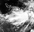
Latest satellite imagery indicates that a depression has formed over west central and adjoining southwest Arabian Sea and lay centred at 1130 hrs IST of today, the 29th October 2011 near latitude 13.00N and longitude 62.00E, about 1400 km west of Mangalore (Karnataka), 850 km east of Socotra Island (Yemen) and 950 km southeast of Salalah (Oman) The system is likely to intensify further into a deep depression and move west northwestwards towards Gulf of Aden during next 72 hrs.
As the depression is expected to move west-northwestwards away from west coast of India, no adverse weather will occur along and off west of coast of India under the influence of this system. However, the system is under constant watch for its further development.
The next bulletin will be issued at 2030 hrs IST of today, the 29th October, 2011
JTWC:
THE AREA OF CONVECTION PREVIOUSLY LOCATED NEAR 10.6N
64.6E, IS NOW LOCATED NEAR 10.6N 64.5E, APPROXIMATELY 780 NM EAST OF
CAPE GUARDAFUI, SOMALIA . ANIMATED WATER VAPOR IMAGERY SHOWS BROKEN,
SCATTERED CONVECTION DISPLACED TO THE NORTH OF A BROAD, SLIGHTLY
ELONGATED, YET WELL DEFINED LOW LEVEL CIRCULATION CENTER (LLCC)
EMBEDDED IN THE MONSOON DEPRESSION. A 280551Z ASCAT PASS CONFIRMS
THE BROAD LLCC, WITH 20 TO 25 KNOT WINDS TO THE NORTH, AND LIGHTER
10 TO 15 KNOTS TO THE SOUTH AND EAST. UPPER LEVEL ANALYSIS INDICATES
THAT THE LLCC IS IN A DIVERGENT REGION, SOUTH OF THE SUBTROPICAL
RIDGE AXIS IN AN AREA OF LOW (5 TO 10 KNOTS) VERTICAL WINDSHEAR,
WITH AN ANTICYCLONE TO THE NORTHEAST PROVIDING AMPLE OUTFLOW. SEA
SURFACE TEMPERATURES IN THE AREA ARE APPROXIMATELY 29 DEGREES
CELSIUS. MAXIMUM SUSTAINED SURFACE WINDS ARE ESTIMATED AT 20 TO 25
KNOTS. MINIMUM SEA LEVEL PRESSURE IS ESTIMATED TO BE NEAR 1005 MB.
THE POTENTIAL FOR THE DEVELOPMENT OF A SIGNIFICANT TROPICAL CYCLONE
WITHIN THE NEXT 24 HOURS REMAINS MEDIUM.
0 likes


