Texas Winter 2011-2012...

Winter Weather Discussion

Moderator: S2k Moderators

Forum rules

The posts in this forum are NOT official forecast and should not be used as such. They are just the opinion of the poster and may or may not be backed by sound meteorological data. They are NOT endorsed by any professional institution or STORM2K.

Help Support Storm2K
Message
Author
User avatar
South Texas Storms
Professional-Met
Professional-Met
Posts: 4226
Joined: Thu Jun 24, 2010 12:28 am
Location: Houston, TX

Re: Texas Winter 2011-2012...

#261 Postby South Texas Storms » Sat Nov 12, 2011 1:10 pm

Portastorm wrote:Nothing too terribly exciting in either the 0z GFS or Euro. Variable pattern. The big "switch" around Thanksgiving looks questionable now doesn't it?

Meanwhile, I'm hoping we can net at least a quarter of an inch of rain on Monday from this next fropa. We (Austin) have been stiffed the last few fropas.


Porta, today's 12z GFS looks good for our rain chances on Monday. We better not get dry slotted again! I think I will cry if we do!
0 likes   

User avatar
Rgv20
S2K Supporter
S2K Supporter
Posts: 2466
Age: 38
Joined: Wed Jan 05, 2011 5:42 pm
Location: Edinburg/McAllen Tx

#262 Postby Rgv20 » Sat Nov 12, 2011 4:51 pm

Regarding rain chances for Central, East and South Texas, I think they are starting to look better for the Monday Night/Tuesday Morning time frame. The 18zNAM is much stronger with the upper level low much like the 12zUKMET and ECMWF. The potential for severe weather is not out of the question but we will have to wait and see.

This is the Forecast 500mb Vorticity by the 18zNAM Valid for Tuesday 6AM.
Image


This is the Forecast 500mb Vorticity by the 12zUKMET Valid for Tuesday 6AM.
Image
0 likes   
The following post is NOT an official forecast and should not be used as such. It is just the opinion of the poster and may or may not be backed by sound meteorological data. It is NOT endorsed by any professional institution including storm2k.org For Official Information please refer to the NHC and NWS products.

User avatar
Portastorm
Storm2k Moderator
Storm2k Moderator
Posts: 9914
Age: 63
Joined: Fri Jul 11, 2003 9:16 am
Location: Round Rock, TX
Contact:

Re: Texas Winter 2011-2012...

#263 Postby Portastorm » Sat Nov 12, 2011 6:15 pm

Yeah, the NWS forecasters out of New Braunfels seemed bullish as well in their afternoon forecast discussion. Apparently 12z guidance slowed the upper low some and the 18z even more. Could end up seeing some severe weather along with heavy rain, although I will believe it when I see it.

Like I said the last couple of setups have looked good as well and ended up panning out ... at least for me and my pal South Texas Storms!
0 likes   
Any forecasts under my name are to be taken with a grain of salt. Get your best forecasts from the National Weather Service and National Hurricane Center.

User avatar
iorange55
Category 5
Category 5
Posts: 2388
Joined: Thu Nov 13, 2008 9:47 pm
Location: Big D

Re: Texas Winter 2011-2012...

#264 Postby iorange55 » Sat Nov 12, 2011 11:10 pm

Still looking like there should be a cool down around Thanksgiving. GFS keeps going back and forth on it, though.


We haven't really had a big ice storm in awhile, so I am predicting one this winter. Let it be known.
0 likes   

User avatar
Ntxw
Storm2k Moderator
Storm2k Moderator
Posts: 22785
Joined: Wed Oct 21, 2009 6:34 pm
Location: DFW, Texas

Re: Texas Winter 2011-2012...

#265 Postby Ntxw » Sun Nov 13, 2011 12:30 am

iorange55 wrote:Still looking like there should be a cool down around Thanksgiving. GFS keeps going back and forth on it, though.


We haven't really had a big ice storm in awhile, so I am predicting one this winter. Let it be known.


I'm pretty sure we had a big ice storm before the snow that kept everyone home for a week in Feb. Everyone was sliding in their cars for awhile. :wink: Or are you talking about a pure sleet storm?
0 likes   
The above post and any post by Ntxw is NOT an official forecast and should not be used as such. It is just the opinion of the poster and may or may not be backed by sound meteorological data. It is NOT endorsed by any professional institution including Storm2k. For official information, please refer to NWS products.

  Help support Storm2K!
Help Support Storm2K

User avatar
Rgv20
S2K Supporter
S2K Supporter
Posts: 2466
Age: 38
Joined: Wed Jan 05, 2011 5:42 pm
Location: Edinburg/McAllen Tx

#266 Postby Rgv20 » Sun Nov 13, 2011 12:35 am

Taking a look at the 0zNAM it looks like the chance of some severe storms is going up for Monday Night anywhere from Austin down to Laredo. The NAM is forecasting Cape values anywhere from 1,000 to 2,000 for Central and South Texas. Hopefully my friends Portastorm and South Texas Storms get a good drink out of this!!
0 likes   
The following post is NOT an official forecast and should not be used as such. It is just the opinion of the poster and may or may not be backed by sound meteorological data. It is NOT endorsed by any professional institution including storm2k.org For Official Information please refer to the NHC and NWS products.

User avatar
iorange55
Category 5
Category 5
Posts: 2388
Joined: Thu Nov 13, 2008 9:47 pm
Location: Big D

Re: Texas Winter 2011-2012...

#267 Postby iorange55 » Sun Nov 13, 2011 12:50 am

Ntxw wrote:
iorange55 wrote:Still looking like there should be a cool down around Thanksgiving. GFS keeps going back and forth on it, though.


We haven't really had a big ice storm in awhile, so I am predicting one this winter. Let it be known.


I'm pretty sure we had a big ice storm before the snow that kept everyone home for a week in Feb. Everyone was sliding in their cars for awhile. :wink: Or are you talking about a pure sleet storm?


Yeah, I'm talking about a good ol' sleet storm. Like the one we had back 2003? I believe.
0 likes   

User avatar
South Texas Storms
Professional-Met
Professional-Met
Posts: 4226
Joined: Thu Jun 24, 2010 12:28 am
Location: Houston, TX

Re: Texas Winter 2011-2012...

#268 Postby South Texas Storms » Sun Nov 13, 2011 3:22 am

Yeah Porta and Rgv, it looks really good for for south central TX! I really hope this pans out! And I hope you get some rain down there too in Rio Grande City!
0 likes   

User avatar
gboudx
S2K Supporter
S2K Supporter
Posts: 4080
Joined: Thu Sep 04, 2003 1:39 pm
Location: Rockwall, Tx but from Harvey, La

Re: Texas Winter 2011-2012...

#269 Postby gboudx » Sun Nov 13, 2011 10:08 am

iorange55 wrote:Yeah, I'm talking about a good ol' sleet storm. Like the one we had back 2003? I believe.


We had 3" of sleet during that sleet storm. My driveway was a solid block of ice. As long as it melts in a day or 2, I'm fine with it.
0 likes   

User avatar
Portastorm
Storm2k Moderator
Storm2k Moderator
Posts: 9914
Age: 63
Joined: Fri Jul 11, 2003 9:16 am
Location: Round Rock, TX
Contact:

Re: Texas Winter 2011-2012...

#270 Postby Portastorm » Sun Nov 13, 2011 11:37 am

South Texas Storms wrote:Yeah Porta and Rgv, it looks really good for for south central TX! I really hope this pans out! And I hope you get some rain down there too in Rio Grande City!


Here, here ... let's get us a nice north-south oriented precip mass that soaks the Valley on up the I-35 corridor!

Set up still looking good for heavy rain and some possible severe weather later Monday into the evening and overnight hours into Tuesday. One half inch to one inch totals looking commonplace ... boy would that be nice?!
0 likes   
Any forecasts under my name are to be taken with a grain of salt. Get your best forecasts from the National Weather Service and National Hurricane Center.

User avatar
Rgv20
S2K Supporter
S2K Supporter
Posts: 2466
Age: 38
Joined: Wed Jan 05, 2011 5:42 pm
Location: Edinburg/McAllen Tx

#271 Postby Rgv20 » Sun Nov 13, 2011 12:20 pm

:uarrow: That would be awesome but I'm not going to hold my breath as it looks like most of the energy is going to stay north of the RGV. But you never know as there has been numerous times where the forecast calls for the Convective line was supposed to stay north of us and it just builds south and follows the Rio Grande River! :double:


This graphic provided by the NWS in Forth Worth looks really nice thou :D

Image
0 likes   
The following post is NOT an official forecast and should not be used as such. It is just the opinion of the poster and may or may not be backed by sound meteorological data. It is NOT endorsed by any professional institution including storm2k.org For Official Information please refer to the NHC and NWS products.

User avatar
Rgv20
S2K Supporter
S2K Supporter
Posts: 2466
Age: 38
Joined: Wed Jan 05, 2011 5:42 pm
Location: Edinburg/McAllen Tx

#272 Postby Rgv20 » Mon Nov 14, 2011 12:46 am

Special Weather Statement

SPECIAL WEATHER STATEMENT
NATIONAL WEATHER SERVICE AUSTIN/SAN ANTONIO TX
826 PM CST SUN NOV 13 2011

TXZ171>173-183>194-202>209-217>225-228-141300-
LLANO-BURNET-WILLIAMSON-VAL VERDE-EDWARDS-REAL-KERR-BANDERA-
GILLESPIE-KENDALL-BLANCO-HAYS-TRAVIS-BASTROP-LEE-KINNEY-UVALDE-
MEDINA-BEXAR-COMAL-GUADALUPE-CALDWELL-FAYETTE-MAVERICK-ZAVALA-
FRIO-ATASCOSA-WILSON-KARNES-GONZALES-DE WITT-LAVACA-DIMMIT-
INCLUDING THE CITIES OF...LLANO...BURNET...GEORGETOWN...DEL RIO...
ROCKSPRINGS...LEAKEY...KERRVILLE...BANDERA...FREDERICKSBURG...
BOERNE...BLANCO...SAN MARCOS...AUSTIN...BASTROP...GIDDINGS...
BRACKETTVILLE...UVALDE...HONDO...SAN ANTONIO...NEW BRAUNFELS...
SEGUIN...LOCKHART...LA GRANGE...EAGLE PASS...CRYSTAL CITY...
PEARSALL...PLEASANTON...FLORESVILLE...KARNES CITY...GONZALES...
CUERO...HALLETTSVILLE...CARRIZO SPRINGS
826 PM CST SUN NOV 13 2011

...MUCH NEEDED RAINFALL LIKELY MONDAY NIGHT THROUGH TUESDAY...

AN UPPER LEVEL STORM SYSTEM CURRENTLY OFFSHORE OF THE BAJA OF
MEXICO WILL MOVE EAST ACROSS SOUTH CENTRAL TEXAS LATE MONDAY NIGHT
THROUGH TUESDAY. SCATTERED TO NUMEROUS SHOWERS AND THUNDERSTORMS
WILL DEVELOP LATE MONDAY NIGHT ACROSS WESTERN PORTIONS OF THE AREA
AND TRANSITION EAST TO THE INTERSTATE 35 CORRIDOR TUESDAY MORNING...
THEN CONTINUE EAST OUT OF SOUTH CENTRAL TEXAS TUESDAY AFTERNOON.

STORM TOTAL RAINFALL AMOUNTS WILL RANGE FROM ONE TO TWO INCHES
WITH HEAVY DOWNPOURS AFFECTING MUCH OF THE AREA. IN ADDITION...A
FEW STORMS MAY APPROACH SEVERE LEVELS.

GO TO http://WWW.SRH.NOAA.GOV/EWX FOR THE LATEST INFORMATION...FORECASTS
AND WARNINGS.

$$
0 likes   
The following post is NOT an official forecast and should not be used as such. It is just the opinion of the poster and may or may not be backed by sound meteorological data. It is NOT endorsed by any professional institution including storm2k.org For Official Information please refer to the NHC and NWS products.

User avatar
iorange55
Category 5
Category 5
Posts: 2388
Joined: Thu Nov 13, 2008 9:47 pm
Location: Big D

Re: Texas Winter 2011-2012...

#273 Postby iorange55 » Mon Nov 14, 2011 3:13 pm

Yuck. Unless some things start changing, it looks like November will be a warm month.

Not a good start.
0 likes   

User avatar
Ntxw
Storm2k Moderator
Storm2k Moderator
Posts: 22785
Joined: Wed Oct 21, 2009 6:34 pm
Location: DFW, Texas

#274 Postby Ntxw » Mon Nov 14, 2011 4:38 pm

The summer that just won't quit!!! Anyone notice how horribly the models have been mid range lately on this storm bringing rain in the coming hours (heck mid range overall)? I know they struggle with cutoffs but jeesh, NAM almost loses the entire thing over TX lol.
0 likes   
The above post and any post by Ntxw is NOT an official forecast and should not be used as such. It is just the opinion of the poster and may or may not be backed by sound meteorological data. It is NOT endorsed by any professional institution including Storm2k. For official information, please refer to NWS products.


  Help support Storm2K!

Help Support Storm2K


User avatar
Portastorm
Storm2k Moderator
Storm2k Moderator
Posts: 9914
Age: 63
Joined: Fri Jul 11, 2003 9:16 am
Location: Round Rock, TX
Contact:

Re:

#275 Postby Portastorm » Mon Nov 14, 2011 5:09 pm

Ntxw wrote:The summer that just won't quit!!! Anyone notice how horribly the models have been mid range lately on this storm bringing rain in the coming hours (heck mid range overall)? I know they struggle with cutoffs but jeesh, NAM almost loses the entire thing over TX lol.


The NWSFO out of New Braunfels somewhat addressed that issue in their afternoon AFD just issued and said the upper low is supposed to shear out as it moves across Texas. Nevertheless, your assertion is quite accurate. Medium-range models have been wildly divergent from run to run. I guess it is somewhat expected in a La Nina year or so I read. IIRC, didn't we see similiar last winter from the models?
0 likes   
Any forecasts under my name are to be taken with a grain of salt. Get your best forecasts from the National Weather Service and National Hurricane Center.

aggiecutter
Category 5
Category 5
Posts: 1753
Joined: Thu Oct 14, 2004 9:22 pm
Location: Texarkana

Re: Texas Winter 2011-2012...

#276 Postby aggiecutter » Mon Nov 14, 2011 6:03 pm

According to the Shreveport AFD, we could see severe weather and more importantly heavy rainfall tomorrow. As far as La Nina winters are concerned, the two that standout in my mind(2000 and 2010) were characterized by 3-4 weeks of intense winter. However, before and after those wintery periods were well above normal. The 2000 wintery period occurred from Mid December through Early January, and the 2010 wintry period lasted from Early January to Early February.

Shreveport AFD:

"WE COULD SEE A
VERY ACTIVE DAY ON TUESDAY WITH LARGE HAIL...DAMAGING WIND GUSTS
AND ISOLATED TORNADOES. AS FAR AS RAINFALL POTENTIAL...STILL
LOOKING LIKE A WIDESPREAD ONE TO TWO INCH RAINFALL EVENT FOR THE
NORTHWEST HALF OF THE REGION...WITH THE HIGHER TOTALS...ISOLATED
THREE TO FOUR INCH AMOUNTS...ACROSS THE NORTHERN HALF OF NORTHEAST
TEXAS...MCCURTAIN COUNTY IN SOUTHEAST OKLAHOMA...AND SOUTHWEST
ARKANSAS."
0 likes   

User avatar
Rgv20
S2K Supporter
S2K Supporter
Posts: 2466
Age: 38
Joined: Wed Jan 05, 2011 5:42 pm
Location: Edinburg/McAllen Tx

Re: Texas Winter 2011-2012...

#277 Postby Rgv20 » Mon Nov 14, 2011 6:25 pm

iorange55 wrote:Yuck. Unless some things start changing, it looks like November will be a warm month.

Not a good start.


It looks like the cold weather its going to have to wait until December as the remainder of November should be on the warm side. Just for fun even the NOGAPS Ensembles are in total agreement with the GFS and ECMWF 500mb pattern in the next 7 to 10 days which would result in warm weather for Texas.


This is the 12zNOGAPS Ensembles 500mb Height Anomalies Forecast Valid for Monday 6am. Notice the positive anomalies in the southeastern US which would result in warm weather and the negative anomalies keeping the unsettled and cool weather in the western US.
Image


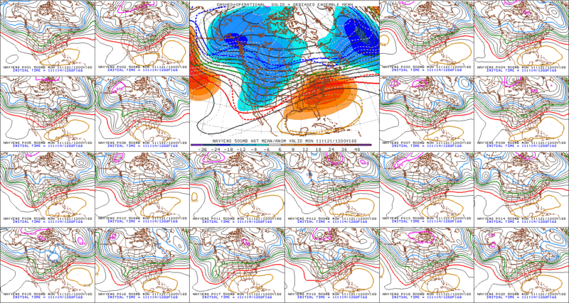
12zNOGAPS Ensembles 500mb Height Anomalies Forecast Valid for Thursday (11/24) 6am. The forecast still calls for the cool and unsettled weather to be confined in the western US. For the most part Texas should stay in the warm side for at least the next 10 days.
Image


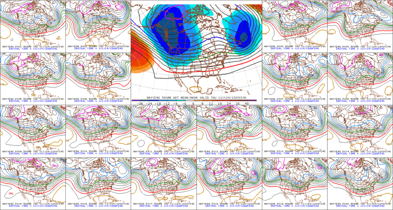
I know the NOGAPS is not a reliable model but I posted it just to show that all long range guidance (CMC Ensemble,GFS Ensemble, ECMWF Ensembles) agree on the 500mb pattern thru at least the next 10 days.
0 likes   
The following post is NOT an official forecast and should not be used as such. It is just the opinion of the poster and may or may not be backed by sound meteorological data. It is NOT endorsed by any professional institution including storm2k.org For Official Information please refer to the NHC and NWS products.

User avatar
somethingfunny
ChatStaff
ChatStaff
Posts: 3926
Age: 37
Joined: Thu May 31, 2007 10:30 pm
Location: McKinney, Texas

Re:

#278 Postby somethingfunny » Mon Nov 14, 2011 11:13 pm

somethingfunny (on November 2nd) wrote:Interesting, the GFS hasn't dropped that 11/15 date for the first major freeze. Usually these cold snaps get pushed back and pushed back and always stay out there by 384 hours. I know, it's still 336 hours out, but it's progress. :lol:

We'll see if the cold air in that forecast moderates as we get closer to mid November but I think the date of that cold snap might be a reliable bet.


I am so ashamed and angry at the GFLucyS. :grr:

What was the bet for again? :oops:
0 likes   
I am not a meteorologist, and any posts made by me are not official forecasts or to be interpreted as being intelligent. These posts are just my opinions and are probably silly opinions.

gpsnowman
S2K Supporter
S2K Supporter
Posts: 3185
Joined: Fri Jan 07, 2011 10:35 am
Location: Grand Prairie Tx

#279 Postby gpsnowman » Tue Nov 15, 2011 10:17 am

I can't remember a November so warm and especially humid. This is depressing. With a warm Thanksgiving probable it is not going to get better soon. The autumn leaves are slow in changing this year. It does not have the look or feel of mid November that's for sure. Some trees have great color but it is very sporadic and uneven. Some are dead from the summer. Sigh. Well, a couple days in the 60's with less humidty will be nice before more warmth and muggy air invades.
0 likes   

User avatar
gboudx
S2K Supporter
S2K Supporter
Posts: 4080
Joined: Thu Sep 04, 2003 1:39 pm
Location: Rockwall, Tx but from Harvey, La

#280 Postby gboudx » Tue Nov 15, 2011 10:35 am

I don't mind this weather. It's good for outdoor sports and is much better than the sucky summer we had.
0 likes   


Return to “Winter Weather”

Who is online

Users browsing this forum: No registered users and 5 guests