Texas Winter 2011-2012...

Winter Weather Discussion

Moderator: S2k Moderators

Forum rules

The posts in this forum are NOT official forecast and should not be used as such. They are just the opinion of the poster and may or may not be backed by sound meteorological data. They are NOT endorsed by any professional institution or STORM2K.

Help Support Storm2K
Message
Author
ndale
Category 1
Category 1
Posts: 429
Joined: Tue Dec 29, 2009 11:12 am
Location: Pflugerville/Austin Tx

Re: Texas Winter 2011-2012...

#301 Postby ndale » Thu Nov 17, 2011 2:09 pm

Turtle wrote:Looks to be getting colder near December. GFS is showing about 3" snow on the first of december.

Yeah the gfs on twisterdata.com is even showing traces of snow for Austin on Dec. 2. I know it's several days out and probably just dreamland but interesting none the less.
0 likes   
Any opinions stated are those of an amateur, please take with several grains of salt and for official forecast refer to the National Weather Service.

User avatar
somethingfunny
ChatStaff
ChatStaff
Posts: 3926
Age: 37
Joined: Thu May 31, 2007 10:30 pm
Location: McKinney, Texas

Re:

#302 Postby somethingfunny » Thu Nov 17, 2011 5:44 pm

TeamPlayersBlue wrote:http://www.weatherbrains.com/special/txsnowstorms.pdf

check out this link above. Did one of you guys make this? I found this while googling "full latitude trough," which Larry Cosgrove was talking about in his blog


This is wonderful.
0 likes   
I am not a meteorologist, and any posts made by me are not official forecasts or to be interpreted as being intelligent. These posts are just my opinions and are probably silly opinions.

User avatar
gboudx
S2K Supporter
S2K Supporter
Posts: 4080
Joined: Thu Sep 04, 2003 1:39 pm
Location: Rockwall, Tx but from Harvey, La

#303 Postby gboudx » Thu Nov 17, 2011 8:43 pm

If you don't get Larry's emails, here's the latest. He continues to talk about the patter change, starting next weekend, to colder.

http://www.examiner.com/weather-in-hous ... ts_article
0 likes   

User avatar
Rgv20
S2K Supporter
S2K Supporter
Posts: 2466
Age: 38
Joined: Wed Jan 05, 2011 5:42 pm
Location: Edinburg/McAllen Tx

#304 Postby Rgv20 » Fri Nov 18, 2011 2:53 am

Just for fun, this is the 0zCMC forecast valid for Sunday morning 11/27. The 0c 850mb line is all the way south of Brownsville! :cold:

Image
0 likes   
The following post is NOT an official forecast and should not be used as such. It is just the opinion of the poster and may or may not be backed by sound meteorological data. It is NOT endorsed by any professional institution including storm2k.org For Official Information please refer to the NHC and NWS products.

SaskatchewanScreamer

Re:

#305 Postby SaskatchewanScreamer » Fri Nov 18, 2011 7:21 am

Rgv20 wrote:Just for fun, this is the 0zCMC forecast valid for Sunday morning 11/27. The 0c 850mb line is all the way south of Brownsville! :cold:


:jacket:
0 likes   

orangeblood
S2K Supporter
S2K Supporter
Posts: 3714
Joined: Tue Dec 15, 2009 6:14 pm
Location: Fort Worth, TX

Re:

#306 Postby orangeblood » Fri Nov 18, 2011 8:35 pm

Ntxw wrote:I think the NAO is a bit too overplayed here in TX. It usually brings us NW flow aloft which is cooler temps but nothing extraordinary as the brunt of troughs aim for the eastern seaboard. It's mostly a player along the east coast as the Atlantic has more of the influence there, December is the month I've noticed that it likes to go negative recently.

Almost every time, the major arctic outbreaks here is a net result of the PNA going positive. No matter what the other signals say, a good +PNA will call for exciting times in the southern plains and can overwhelm the pattern. The AO is of course the enhancer to everything. That's where I would look.

Early next week looks wet for Texas, maybe even some severe weather possible.


Another good indicator for winter weather in the southern US is the location of warming in the stratosphere at the 10-30mb level around 60N and up to the North Pole. This warming high up in the atmosphere usually predisposes warming and ridging underneath it. Currently this stratospheric warming is underway across the Northeast Pacific into the Gulf of Alaska, which should translate into the PNA going positive in a couple of weeks. Something to keep an eye on!
0 likes   

User avatar
Rgv20
S2K Supporter
S2K Supporter
Posts: 2466
Age: 38
Joined: Wed Jan 05, 2011 5:42 pm
Location: Edinburg/McAllen Tx

#307 Postby Rgv20 » Sat Nov 19, 2011 2:17 am

I know we all are eagerly waiting for some cold weather but the GFS has been showing some decent rainfall totals thru the next 8 days. The pic below is tonight's 0zGFS which shows a good portion of the Lone Star State with anywhere from 1 to 4 total inches of rain thru next Saturday evening. Hopefully this rain event pans out! :D

Image
0 likes   
The following post is NOT an official forecast and should not be used as such. It is just the opinion of the poster and may or may not be backed by sound meteorological data. It is NOT endorsed by any professional institution including storm2k.org For Official Information please refer to the NHC and NWS products.

User avatar
Portastorm
Storm2k Moderator
Storm2k Moderator
Posts: 9914
Age: 63
Joined: Fri Jul 11, 2003 9:16 am
Location: Round Rock, TX
Contact:

Re: Texas Winter 2011-2012...

#308 Postby Portastorm » Sat Nov 19, 2011 10:34 am

As I have been saying, the medium-range models (GFS and Euro) have been highly variable from run to run regarding the 10-15 day period. Yesterday both models looked fairly warm. Today, much different story with both models portending a major cold outbreak by early December.

Get a load of this 0z Euro (below). We have a full latitude trough followed by an outbreak of very cold air from Canada. This would be quite entertaining should it come to fruition!

http://www.meteo.psu.edu/~gadomski/ECMWF0.5_0z/ecmwfloop.html
0 likes   
Any forecasts under my name are to be taken with a grain of salt. Get your best forecasts from the National Weather Service and National Hurricane Center.

User avatar
Ntxw
Storm2k Moderator
Storm2k Moderator
Posts: 22785
Joined: Wed Oct 21, 2009 6:34 pm
Location: DFW, Texas

#309 Postby Ntxw » Sat Nov 19, 2011 10:57 am

It's all a tease!!! Don't believe it! They influenced the Canadians too. Lucy is at work already.

Image

Uploaded with ImageShack.us

Hm, I wonder if the recent Baja-Texas-Ohio Valley southern storm track is an indicator of the winter to come. Sure looks good.
0 likes   
The above post and any post by Ntxw is NOT an official forecast and should not be used as such. It is just the opinion of the poster and may or may not be backed by sound meteorological data. It is NOT endorsed by any professional institution including Storm2k. For official information, please refer to NWS products.

  Help support Storm2K!
Help Support Storm2K

User avatar
TeamPlayersBlue
Category 5
Category 5
Posts: 3445
Joined: Tue Feb 02, 2010 1:44 am
Location: Denver/Applewood, CO

#310 Postby TeamPlayersBlue » Sat Nov 19, 2011 12:29 pm

I'm starting to see SOME similarities to 1989. I found this website the other day while looking at the latest in SST anomalies. That shows some similarities to 1989 because we are coming out of a La nina. http://www.cpc.ncep.noaa.gov/products/a ... ears.shtml
Also, i read on accuweather that temperature readings in Alaska are breaking records from 1989. I know this is a BIG statement since it held some of the biggest outbreaks in history but something to look at. Anyone care to add to this thesis?
0 likes   
Personal Forecast Disclaimer:
The posts in this forum are NOT official forecast and should not be used as such. They are just the opinion of the poster and may or may not be backed by sound meteorological data. They are NOT endorsed by any professional institution or storm2k.org. For official information, please refer to the NHC and NWS products.

User avatar
Portastorm
Storm2k Moderator
Storm2k Moderator
Posts: 9914
Age: 63
Joined: Fri Jul 11, 2003 9:16 am
Location: Round Rock, TX
Contact:

Re: Texas Winter 2011-2012...

#311 Postby Portastorm » Sat Nov 19, 2011 1:08 pm

While Nina has weakened, I don't know that I would say we are coming out of a La Nina. The values are still strong enough and the forecast suggests it'll continue through the winter.
0 likes   
Any forecasts under my name are to be taken with a grain of salt. Get your best forecasts from the National Weather Service and National Hurricane Center.

User avatar
cycloneye
Admin
Admin
Posts: 145308
Age: 68
Joined: Thu Oct 10, 2002 10:54 am
Location: San Juan, Puerto Rico

Re: Texas Winter 2011-2012...

#312 Postby cycloneye » Sat Nov 19, 2011 1:24 pm

Portastorm wrote:While Nina has weakened, I don't know that I would say we are coming out of a La Nina. The values are still strong enough and the forecast suggests it'll continue through the winter.


Porta,La Nina is still hanging on,but we have to watch if that warm pool moves east and change things in the next 2-4 months. For those who may want to know how ENSO is doing go here

Image
0 likes   
Visit the Caribbean-Central America Weather Thread where you can find at first post web cams,radars
and observations from Caribbean basin members Click Here

User avatar
Rgv20
S2K Supporter
S2K Supporter
Posts: 2466
Age: 38
Joined: Wed Jan 05, 2011 5:42 pm
Location: Edinburg/McAllen Tx

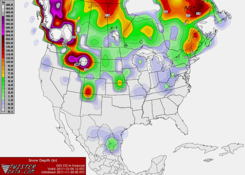
#313 Postby Rgv20 » Sat Nov 19, 2011 4:17 pm

I was looking over the 12zGFS Ensembles and they are hinting at an interesting pattern to start the month of December.

This is the 12zGFS Ensembles 500mb Anomaly forecast valid for Wednesday Evening 11/30/2011.

Image


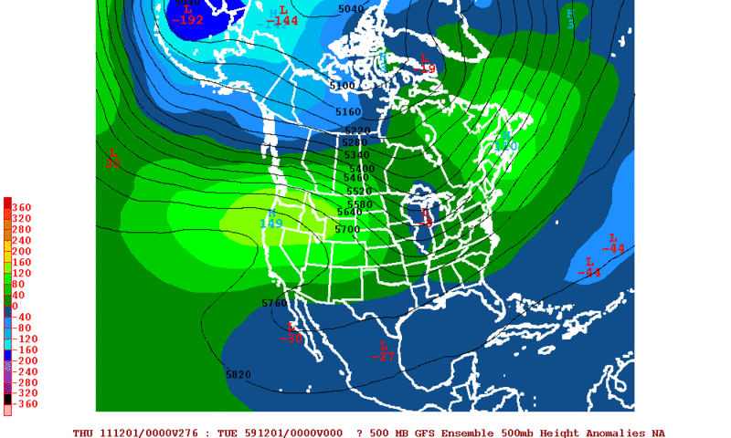
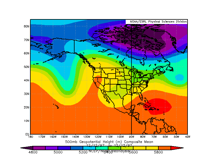
The forecast map above is rather similar to the pattern set up back in December 12 1997 that brought cold conditions to Texas.

Image


Of course all of these is just speculation but looking at the long range ensemble guidance it does look like December should start on a chilly side.
0 likes   
The following post is NOT an official forecast and should not be used as such. It is just the opinion of the poster and may or may not be backed by sound meteorological data. It is NOT endorsed by any professional institution including storm2k.org For Official Information please refer to the NHC and NWS products.

richtrav
Tropical Storm
Tropical Storm
Posts: 184
Joined: Mon Sep 19, 2005 9:48 pm
Location: South Texas

Re:

#314 Postby richtrav » Sat Nov 19, 2011 4:23 pm

TeamPlayersBlue wrote:I'm starting to see SOME similarities to 1989. I found this website the other day while looking at the latest in SST anomalies. That shows some similarities to 1989 because we are coming out of a La nina. http://www.cpc.ncep.noaa.gov/products/a ... ears.shtml
Also, i read on accuweather that temperature readings in Alaska are breaking records from 1989. I know this is a BIG statement since it held some of the biggest outbreaks in history but something to look at. Anyone care to add to this thesis?


2008 and 1996 look like decent matches as far as SST trends and cold in AK goes.
0 likes   

User avatar
Rgv20
S2K Supporter
S2K Supporter
Posts: 2466
Age: 38
Joined: Wed Jan 05, 2011 5:42 pm
Location: Edinburg/McAllen Tx

#315 Postby Rgv20 » Sun Nov 20, 2011 1:26 am

The GFS Ensembles still look good on a pattern change to colder weather for Texas starting early December. Oh and just for fun this is tonight's 0zGFS operational run which shows some traces of snow for my area near its end of the forecast cycle :lol:

Image
0 likes   
The following post is NOT an official forecast and should not be used as such. It is just the opinion of the poster and may or may not be backed by sound meteorological data. It is NOT endorsed by any professional institution including storm2k.org For Official Information please refer to the NHC and NWS products.

User avatar
South Texas Storms
Professional-Met
Professional-Met
Posts: 4226
Joined: Thu Jun 24, 2010 12:28 am
Location: Houston, TX

Re: Texas Winter 2011-2012...

#316 Postby South Texas Storms » Sun Nov 20, 2011 2:33 am

lol go Rgv! Let's hope that snowfall map pans out for you guys down there! :lol:
Have you noticed that the Day 11-15 GFS Ensemble has consistently been showing a wet and cooler pattern for Texas?
Maybe there actually will be some winter precip. chances in a few weeks?
0 likes   

User avatar
Portastorm
Storm2k Moderator
Storm2k Moderator
Posts: 9914
Age: 63
Joined: Fri Jul 11, 2003 9:16 am
Location: Round Rock, TX
Contact:

Re: Texas Winter 2011-2012...

#317 Postby Portastorm » Sun Nov 20, 2011 11:12 am

Snow in the Rio Grande Valley?! Preposterous! That NEVER happens. :ggreen:
0 likes   
Any forecasts under my name are to be taken with a grain of salt. Get your best forecasts from the National Weather Service and National Hurricane Center.

User avatar
Ptarmigan
Category 5
Category 5
Posts: 5313
Joined: Wed Aug 16, 2006 9:06 pm

Re:

#318 Postby Ptarmigan » Sun Nov 20, 2011 11:52 am

TeamPlayersBlue wrote:I'm starting to see SOME similarities to 1989. I found this website the other day while looking at the latest in SST anomalies. That shows some similarities to 1989 because we are coming out of a La nina. http://www.cpc.ncep.noaa.gov/products/a ... ears.shtml
Also, i read on accuweather that temperature readings in Alaska are breaking records from 1989. I know this is a BIG statement since it held some of the biggest outbreaks in history but something to look at. Anyone care to add to this thesis?


Interesting you mention December 1989. The winter of 1989-1990 was Neutral. The previous winter of 1988-1989 was La Nina. One difference is that we are in a weak La Nina.

Alaska's Brutal Cold Reaches Historical Status
http://www.accuweather.com/blogs/news/s ... es-his.asp
0 likes   

User avatar
Ntxw
Storm2k Moderator
Storm2k Moderator
Posts: 22785
Joined: Wed Oct 21, 2009 6:34 pm
Location: DFW, Texas

Re: Texas Winter 2011-2012...

#319 Postby Ntxw » Sun Nov 20, 2011 1:59 pm

Holy turkey potato :eek:

Image

Uploaded with ImageShack.us

Fun to look at! Southern plains winter storm anyone?
0 likes   
The above post and any post by Ntxw is NOT an official forecast and should not be used as such. It is just the opinion of the poster and may or may not be backed by sound meteorological data. It is NOT endorsed by any professional institution including Storm2k. For official information, please refer to NWS products.


  Help support Storm2K!

Help Support Storm2K


User avatar
Rgv20
S2K Supporter
S2K Supporter
Posts: 2466
Age: 38
Joined: Wed Jan 05, 2011 5:42 pm
Location: Edinburg/McAllen Tx

#320 Postby Rgv20 » Sun Nov 20, 2011 4:22 pm

:uarrow: The Euro is forecasting 3-6 inches of snow for central Oklahoma from Sunday to Monday Noon :froze: The ECMWF Ensemble Control Run is colder than the operational run as it has the 850mb 0c line south of Brownsville by Monday morning...It's going to be interesting to see how this unfolds in the next couple of days.
0 likes   
The following post is NOT an official forecast and should not be used as such. It is just the opinion of the poster and may or may not be backed by sound meteorological data. It is NOT endorsed by any professional institution including storm2k.org For Official Information please refer to the NHC and NWS products.


Return to “Winter Weather”

Who is online

Users browsing this forum: No registered users and 5 guests