Western Caribbean
Moderator: S2k Moderators
Forum rules

The posts in this forum are NOT official forecasts and should not be used as such. They are just the opinion of the poster and may or may not be backed by sound meteorological data. They are NOT endorsed by any professional institution or STORM2K. For official information, please refer to products from the National Hurricane Center and National Weather Service.
-
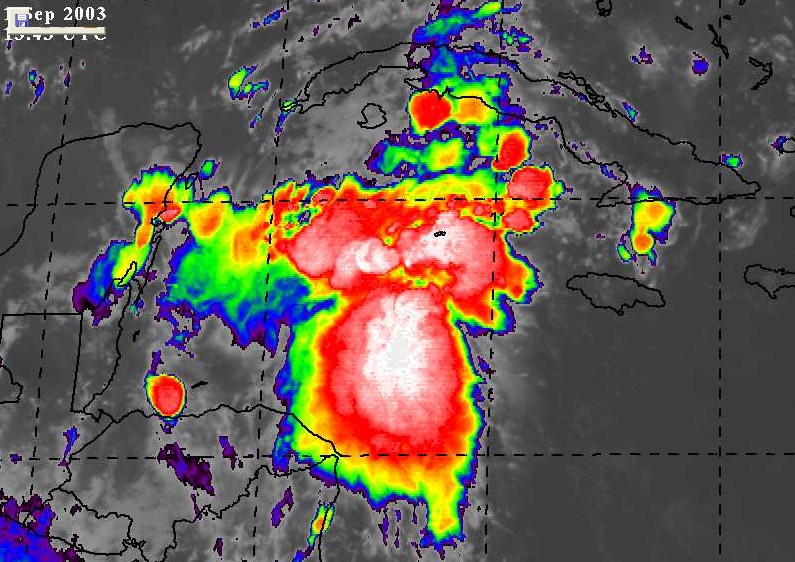
Rainband


-
vbhoutex

- Storm2k Executive

- Posts: 29150
- Age: 74
- Joined: Wed Oct 09, 2002 11:31 pm
- Location: Cypress, TX
- Contact:
Noting a definite mid-level swirl in the area immediately off the coast of Honduras and Belize moving W to WNW slowly. This will take it over the S portion of the Yucatan and possibly into the Bay of Campeche. The other possibility that this portion of the area will move into the EPAC.
No matter what I'm watching this one too!!! Current progs for our area are for a rainy week and we sure have started out on the right foot for that!!
And now that I have seen some models on this one, I will still be watching it. Right now the movement, at least of the noted swirl is still WNW.
No matter what I'm watching this one too!!! Current progs for our area are for a rainy week and we sure have started out on the right foot for that!!
And now that I have seen some models on this one, I will still be watching it. Right now the movement, at least of the noted swirl is still WNW.
0 likes
Skywarn, C.E.R.T.
Please click below to donate to STORM2K to help with the expenses of keeping the site going:

Please click below to donate to STORM2K to help with the expenses of keeping the site going:


-
weatherlover427
-
chadtm80

Two Angry Eyes
Chad...that sat pic is great, thanks. The two systems look like two angry eyes! I guess the season is going to be in full gear the next couple of weeks. Thanks to everyone at Storm2k for making this the best 'Cane Site' on the web. galvbay
0 likes
-
ameriwx2003

- Category 4

- Posts: 980
- Joined: Tue Jul 22, 2003 10:45 am
-
ameriwx2003
- Category 4
- Posts: 980
- Joined: Tue Jul 22, 2003 10:45 am
The latest GFS is joining the ETA on Gulf development. :)
:)
http://www.nco.ncep.noaa.gov/pmb/nwprod ... /fpc.shtml
http://www.nco.ncep.noaa.gov/pmb/nwprod ... /fpc.shtml
http://www.nco.ncep.noaa.gov/pmb/nwprod ... /fpc.shtml
http://www.nco.ncep.noaa.gov/pmb/nwprod ... /fpc.shtml
0 likes

-
PTrackerLA

- Category 5

- Posts: 5281
- Age: 42
- Joined: Thu Oct 10, 2002 8:40 pm
- Location: Lafayette, LA
-
Rainband
AND FLORIDA!!!wrkh99 wrote:http://www.ssd.noaa.gov/PS/TROP/DATA/RT/watl-ir4-loop.html\
Watch out NO to Texas
THROUGH MID WEEK AND INTERESTING SCENARIO COULD PLAY OUT. AT LEAST
THAT IS WHAT THE ETA AND ESPECIALLY THE GFS ARE INDICATING. THE
MODELS APPEAR TO BE LATCHING ON TO CONVECTION OVER THE WESTERN
CARIBBEAN, ACTUALLY IT STRETCHES FROM GRAND BAHAMA AND THE STRAITS
SOUTHWARD ALL THE WAY TO COSTA RICA. THIS CONVECTION IS VERY
DISORGANIZED, BUT STILL THE MODELS LATCH ON TO IT AND TAKE IT
NORTHWEST. IN FACT THE GFS AND ETA TAKE A VORT MAX THROUGH THE
YUCATAN CHANNEL. IT IS WORTH NOTING THE 00Z MODEL RUNS ARE A BIT
WEAKER WITH THIS THAN THE 18Z RUNS, BUT ARE STILL CONSISTENT WITH
THE EXISTENCE AND MOVEMENT OF THE FEATURE. AT 200 MB BOTH MODELS
FORM AN ANTICYCLONE OVER THE AREA CENTERED ON THE CAYMAN
ISLANDS/JAMAICA REGION LATER TODAY. THE MODELS TAKE THE UPPER RIDGE
WESTWARD INTO THE SOUTHERN GULF. AT THE SAME TIME A TROUGH STARTS TO
DIG SOUTH INTO THE MISSISSIPPI VALLEY, ALTHOUGH THIS LOOKS LIKE IT IS
STRUGGLING TO MAKE IT TOO FAR SOUTH, BUT IT WILL PLAY A PART IN
INCREASING UPPER DIFLUENCE OVER THE STATE. THE VORT MAX AND
CORRESPONDING WEAK SURFACE LOW BECOME NEARLY STATIONARY OFF THE
SOUTHWEST FLORIDA COAST. FOR NOW I WILL PLAY IT WITH JUST A LITTLE
ABOVE CLIMO (MAINLY AFTERNOON CONVECTION) POPS FOR TUESDAY AND
WEDNESDAY, BUT I AM A LITTLE WORRIED WITH WATER LEVELS ALREADY VERY
HIGH AND THE GROUND SATURATED THAT WE COULD BE LOOKING AT A HEAVY
RAIN EVENT LATER THIS WEEK.
0 likes
MOdel link
Does anyone have a link to the models that shows the Caribbean feature moving into the GOM?
0 likes
Who is online
Users browsing this forum: 869MB, Cpv17, HurricaneFan, Ntxw and 143 guests