Texas Winter 2011-2012...

Winter Weather Discussion

Moderator: S2k Moderators

Forum rules

The posts in this forum are NOT official forecast and should not be used as such. They are just the opinion of the poster and may or may not be backed by sound meteorological data. They are NOT endorsed by any professional institution or STORM2K.

Help Support Storm2K
Message
Author
orangeblood
S2K Supporter
S2K Supporter
Posts: 3714
Joined: Tue Dec 15, 2009 6:14 pm
Location: Fort Worth, TX

Re:

#901 Postby orangeblood » Thu Dec 08, 2011 3:47 pm

Portastorm wrote:Something else worth mentioning ... the Arctic Oscillation values continue at very high (positive) levels. One of the analog months/years which matches a weak-moderate Nina with very high AO levels was December 1989.

Do y'all remember what happened here in Texas during that time, especially close to Christmas?! :eek:


Sorry to be a bearer of bad news but after doing some more research, the AO values leading up to the 1989 arctic outbreak were extreme to the negative side. Staying negative for the first 3 weeks of December that year and reaching almost - 3.60 around December 10th, right before the outbreak. It appears to me that it's extremely rare during strong positive AO's to have strong arctic outbreaks, imo.
0 likes   

User avatar
Portastorm
Storm2k Moderator
Storm2k Moderator
Posts: 9914
Age: 63
Joined: Fri Jul 11, 2003 9:16 am
Location: Round Rock, TX
Contact:

Re: Re:

#902 Postby Portastorm » Thu Dec 08, 2011 4:16 pm

orangeblood wrote:
Portastorm wrote:Something else worth mentioning ... the Arctic Oscillation values continue at very high (positive) levels. One of the analog months/years which matches a weak-moderate Nina with very high AO levels was December 1989.

Do y'all remember what happened here in Texas during that time, especially close to Christmas?! :eek:


Sorry to be a bearer of bad news but after doing some more research, the AO values leading up to the 1989 arctic outbreak were extreme to the negative side. Staying negative for the first 3 weeks of December that year and reaching almost - 3.60 around December 10th, right before the outbreak. It appears to me that it's extremely rare during strong positive AO's to have strong arctic outbreaks, imo.


Not bad news at all ... but I feel like an id-jit now! :oops:

Sorry to get everyone excited for no reason. Portastorm needs to go to class to learn how to read historical indices charts better.
0 likes   
Any forecasts under my name are to be taken with a grain of salt. Get your best forecasts from the National Weather Service and National Hurricane Center.

User avatar
Tireman4
S2K Supporter
S2K Supporter
Posts: 5853
Age: 59
Joined: Fri Jun 30, 2006 1:08 pm
Location: Humble, Texas
Contact:

#903 Postby Tireman4 » Thu Dec 08, 2011 4:18 pm

stinking pwc :)
0 likes   

User avatar
Portastorm
Storm2k Moderator
Storm2k Moderator
Posts: 9914
Age: 63
Joined: Fri Jul 11, 2003 9:16 am
Location: Round Rock, TX
Contact:

Re:

#904 Postby Portastorm » Thu Dec 08, 2011 4:59 pm

Tireman4 wrote:stinking pwc :)


Too much Grey Goose, I suppose.
0 likes   
Any forecasts under my name are to be taken with a grain of salt. Get your best forecasts from the National Weather Service and National Hurricane Center.

User avatar
Ntxw
Storm2k Moderator
Storm2k Moderator
Posts: 22786
Joined: Wed Oct 21, 2009 6:34 pm
Location: DFW, Texas

Re: Texas Winter 2011-2012...

#905 Postby Ntxw » Thu Dec 08, 2011 5:44 pm

With the 18z GFS in seems like an active period is going to set up. Light rain/cool/damp conditions for this weekend with shower activity mostly in S Texas. Next week a strong storm will swing through the plains and open the doors for potentially significant cold beginning midweek. After that the jet stream remains active with systems likely traversing while the cold air is still in place. Survive the next several days to a week and we can go back into winter right on cue for the winter solstice! :P :D of course this is all model interpreted so it can change!

And of course on cue you can always count on the GFS the following weekend giving Texas it's first blizzard :P if only...

Image

Uploaded with ImageShack.us

Image

Uploaded with ImageShack.us
0 likes   
The above post and any post by Ntxw is NOT an official forecast and should not be used as such. It is just the opinion of the poster and may or may not be backed by sound meteorological data. It is NOT endorsed by any professional institution including Storm2k. For official information, please refer to NWS products.

  Help support Storm2K!
Help Support Storm2K

BrokenGlassRepublicn
Category 1
Category 1
Posts: 481
Joined: Sun Nov 20, 2011 8:07 pm
Location: Richardson, Texas

Re:

#906 Postby BrokenGlassRepublicn » Thu Dec 08, 2011 6:15 pm

Portastorm wrote:Hey look ... I just posted it as one of those weather items where you read it and think "hmmm ... that's kinda interesting." Who knows if it will verify. December 1989 was such an extreme event that the odds of anything like that happening this year are pretty slim. Most of us may never see anything like that in our lifetime.


I remember hearing the same things about the Summer of 1980. Unfortunately, I saw another one like that in my lifetime. Speaking of which, what was the winter of 1980-1 like? I don't remember that one very much.
0 likes   

Turtle
Category 1
Category 1
Posts: 285
Joined: Wed Jan 20, 2010 9:02 pm
Location: East Texas

Re: Texas Winter 2011-2012...

#907 Postby Turtle » Thu Dec 08, 2011 6:46 pm

18Z GFS looks great! It's showing about 10" of snow where I live. It is far off, but it's within 10 days now.

Image
0 likes   

User avatar
Ntxw
Storm2k Moderator
Storm2k Moderator
Posts: 22786
Joined: Wed Oct 21, 2009 6:34 pm
Location: DFW, Texas

Re: Texas Winter 2011-2012...

#908 Postby Ntxw » Thu Dec 08, 2011 7:16 pm

I found this interesting. The past few years has prompted the metroplex to order snow plows! Never thought I'd live to see this day lol. Who says it never snows in Texas! Seriously though we've been on a lucky run for snow.

http://www.cbsnews.com/8301-505245_162-57337800/first-snow-plows...

The Dallas-Fort Worth area is getting snow plows less than a year after an icy week that nearly paralyzed the region in the days before its first Super Bowl.

The area will get 29 snow plows -- 14 in Dallas and 15 for Fort Worth -- said Texas Department of Transportation spokesman Mark Pettit. He expects the plows, which will be hooked up to dump trucks, to be operational by the first of the year. Pettit did not know how much the plows would cost.


NTTA also ordered like 14 or so for the toll highways.
0 likes   
The above post and any post by Ntxw is NOT an official forecast and should not be used as such. It is just the opinion of the poster and may or may not be backed by sound meteorological data. It is NOT endorsed by any professional institution including Storm2k. For official information, please refer to NWS products.


  Help support Storm2K!

Help Support Storm2K


User avatar
TeamPlayersBlue
Category 5
Category 5
Posts: 3445
Joined: Tue Feb 02, 2010 1:44 am
Location: Denver/Applewood, CO

#909 Postby TeamPlayersBlue » Thu Dec 08, 2011 7:33 pm

I stated much earlier in this thread that 1989 was one of those years where we were coming off of a strong La nina, and the values were just below normal status. Not sure if that means much much something to look at. Loving the 18z, lets hope for some consistency
0 likes   
Personal Forecast Disclaimer:
The posts in this forum are NOT official forecast and should not be used as such. They are just the opinion of the poster and may or may not be backed by sound meteorological data. They are NOT endorsed by any professional institution or storm2k.org. For official information, please refer to the NHC and NWS products.

User avatar
Rgv20
S2K Supporter
S2K Supporter
Posts: 2466
Age: 39
Joined: Wed Jan 05, 2011 5:42 pm
Location: Edinburg/McAllen Tx

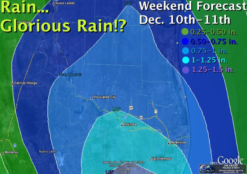
#910 Postby Rgv20 » Thu Dec 08, 2011 8:29 pm

This past two mornings we had back to back freezes in my backyard...Both morning we had low temperatures of 30F :cold:

This coming weekend it looks like the RGV has a good shot of seeing some beneficial rains :D

Image
0 likes   
The following post is NOT an official forecast and should not be used as such. It is just the opinion of the poster and may or may not be backed by sound meteorological data. It is NOT endorsed by any professional institution including storm2k.org For Official Information please refer to the NHC and NWS products.

Turtle
Category 1
Category 1
Posts: 285
Joined: Wed Jan 20, 2010 9:02 pm
Location: East Texas

#911 Postby Turtle » Fri Dec 09, 2011 1:30 am

0z GFS doesn't look as impressive as the 18z. Most places are at or under <1" for Texas. Hopefully the temps can go down 5-10 degrees.
0 likes   

User avatar
somethingfunny
ChatStaff
ChatStaff
Posts: 3926
Age: 37
Joined: Thu May 31, 2007 10:30 pm
Location: McKinney, Texas

Re: Texas Winter 2011-2012...

#912 Postby somethingfunny » Fri Dec 09, 2011 9:58 am

The 6z followed the 0z in keeping the 0°C line well to the north/west of Dallas for that December 18th event. Worth noting though, some sort of severe weather looks possible around December 15th.

And what peek into model la-la land would be complete without a possible White Christmas? :cheesy:

Image

^ That's the 6z. The 0z and even the crazy 18z had nothing close to that, lol. But we can dream, can't we?
0 likes   
I am not a meteorologist, and any posts made by me are not official forecasts or to be interpreted as being intelligent. These posts are just my opinions and are probably silly opinions.

ndale
Category 1
Category 1
Posts: 429
Joined: Tue Dec 29, 2009 11:12 am
Location: Pflugerville/Austin Tx

#913 Postby ndale » Fri Dec 09, 2011 12:56 pm

Looks like the gfs still wants to keep snow in the forecast next weekend from central Tx northward and westward but as someone on another thread says we don't want to get caught up in these models, especially this far out. I haven't seen any other models, does anyone know what they are showing for next weekend.
0 likes   
Any opinions stated are those of an amateur, please take with several grains of salt and for official forecast refer to the National Weather Service.

User avatar
TeamPlayersBlue
Category 5
Category 5
Posts: 3445
Joined: Tue Feb 02, 2010 1:44 am
Location: Denver/Applewood, CO

#914 Postby TeamPlayersBlue » Fri Dec 09, 2011 1:01 pm

Question: Why is it that some 1044 Highs are colder than others? Does it have to do with the source region?
0 likes   
Personal Forecast Disclaimer:
The posts in this forum are NOT official forecast and should not be used as such. They are just the opinion of the poster and may or may not be backed by sound meteorological data. They are NOT endorsed by any professional institution or storm2k.org. For official information, please refer to the NHC and NWS products.

DonWrk
Category 1
Category 1
Posts: 488
Age: 37
Joined: Mon Jan 03, 2011 11:54 pm
Location: Collinsville, TX

#915 Postby DonWrk » Fri Dec 09, 2011 1:04 pm

We just want it to keep showing snow at least nearby, no way it's pinpointed the snow right on location so as long as we can keep seeing this trend then we are in good shape.
0 likes   

User avatar
Portastorm
Storm2k Moderator
Storm2k Moderator
Posts: 9914
Age: 63
Joined: Fri Jul 11, 2003 9:16 am
Location: Round Rock, TX
Contact:

Re:

#916 Postby Portastorm » Fri Dec 09, 2011 1:48 pm

TeamPlayersBlue wrote:Question: Why is it that some 1044 Highs are colder than others? Does it have to do with the source region?


What do you mean exactly? Colder in a particular location?
0 likes   
Any forecasts under my name are to be taken with a grain of salt. Get your best forecasts from the National Weather Service and National Hurricane Center.

User avatar
TeamPlayersBlue
Category 5
Category 5
Posts: 3445
Joined: Tue Feb 02, 2010 1:44 am
Location: Denver/Applewood, CO

Re: Re:

#917 Postby TeamPlayersBlue » Fri Dec 09, 2011 2:08 pm

Portastorm wrote:
TeamPlayersBlue wrote:Question: Why is it that some 1044 Highs are colder than others? Does it have to do with the source region?


What do you mean exactly? Colder in a particular location?


Well it looks like the 1048 MB high expected to come in doesn't have as much cold air as other 1048 highs i've seen. Am i just seeing things? lol
0 likes   
Personal Forecast Disclaimer:
The posts in this forum are NOT official forecast and should not be used as such. They are just the opinion of the poster and may or may not be backed by sound meteorological data. They are NOT endorsed by any professional institution or storm2k.org. For official information, please refer to the NHC and NWS products.

orangeblood
S2K Supporter
S2K Supporter
Posts: 3714
Joined: Tue Dec 15, 2009 6:14 pm
Location: Fort Worth, TX

Re: Texas Winter 2011-2012...

#918 Postby orangeblood » Fri Dec 09, 2011 2:26 pm

After looking over today's 12Z model suites, it looks the biggest factor in whether we get a Texas winter storm next weekend is the strength of the southeast US ridge. If it's as strong as advertised, than most every system the next few weeks will go by to the north of this region but if not, look out, this could be a really nice pattern setting up for Texas winter weather lovers!!
0 likes   

User avatar
Portastorm
Storm2k Moderator
Storm2k Moderator
Posts: 9914
Age: 63
Joined: Fri Jul 11, 2003 9:16 am
Location: Round Rock, TX
Contact:

Re: Re:

#919 Postby Portastorm » Fri Dec 09, 2011 2:37 pm

TeamPlayersBlue wrote:
Portastorm wrote:
TeamPlayersBlue wrote:Question: Why is it that some 1044 Highs are colder than others? Does it have to do with the source region?


What do you mean exactly? Colder in a particular location?


Well it looks like the 1048 MB high expected to come in doesn't have as much cold air as other 1048 highs i've seen. Am i just seeing things? lol


1048mb highs are pretty stout as far as high pressure goes in winter, although some of our classic Arctic outbreaks are ushered in by 1050 mb or higher cells.

As I understand it, you clued in earlier to one reason: source regions of the air. You may have a stout high coming down but if temps in western Canada are not all that cold (in comparison to their average temps), then certainly the air coming into the southern Plains won't be as cold as you might expect.

Something else touched upon ... snow cover ... is important as well. Snow cover in both western Canada and the Plains states.

Also, something which Wxman57 reminds us of every winter ... pay more attention to the 500mb pattern in the GFS runs and not so much the 850mb or surface level. That will clue you in to the potential pattern and dlievery of airmasses.
0 likes   
Any forecasts under my name are to be taken with a grain of salt. Get your best forecasts from the National Weather Service and National Hurricane Center.

User avatar
Ntxw
Storm2k Moderator
Storm2k Moderator
Posts: 22786
Joined: Wed Oct 21, 2009 6:34 pm
Location: DFW, Texas

#920 Postby Ntxw » Fri Dec 09, 2011 2:47 pm

^ Very good points. Source region I've heard is very important. Also direction in which it traverses is important as well. 1048 is cold this time of year but aimed more towards the Midwest and Northeast since the SE ridge is providing a push the opposite way. Orangeblood makes a good case as well. We also don't want the SW lows to cutoff over Baja and sit there too long...It needs to come out all in one piece!!!

Something to keep in mind for January and February, so far this winter the southern stream energies have been the dominant features over the northern stream unlike last year. They have continuously tried to cut off and traveled in the same pattern as they have all fall :wink:
0 likes   
The above post and any post by Ntxw is NOT an official forecast and should not be used as such. It is just the opinion of the poster and may or may not be backed by sound meteorological data. It is NOT endorsed by any professional institution including Storm2k. For official information, please refer to NWS products.


  Help support Storm2K!

Help Support Storm2K


Return to “Winter Weather”

Who is online

Users browsing this forum: No registered users and 6 guests