Why would baja lows sitting there for too long be a bad thing?
Texas Winter 2011-2012...
Moderator: S2k Moderators
Forum rules
 The posts in this forum are NOT official forecast and should not be used as such. They are just the opinion of the poster and may or may not be backed by sound meteorological data. They are NOT endorsed by any professional institution or STORM2K.

The posts in this forum are NOT official forecast and should not be used as such. They are just the opinion of the poster and may or may not be backed by sound meteorological data. They are NOT endorsed by any professional institution or STORM2K.
-
TeamPlayersBlue

- Category 5

- Posts: 3533
- Joined: Tue Feb 02, 2010 1:44 am
- Location: Denver/Applewood, CO
Yeah from talking with you guys and teaching myself over the last few years, the 500 MB chart is very important. Understanding where the source of the cold is vital. Next weeks looks to be coming out of the NW territories. I understand the lack of a snow pack etc as well, but i think the ridge in the SE/ +NAO is what may be throwing me off. Since we have the +NAO, much of the cold air is being strung out towards the east. Got it! 
Why would baja lows sitting there for too long be a bad thing?
Why would baja lows sitting there for too long be a bad thing?
0 likes
Personal Forecast Disclaimer:
The posts in this forum are NOT official forecast and should not be used as such. They are just the opinion of the poster and may or may not be backed by sound meteorological data. They are NOT endorsed by any professional institution or storm2k.org. For official information, please refer to the NHC and NWS products.
The posts in this forum are NOT official forecast and should not be used as such. They are just the opinion of the poster and may or may not be backed by sound meteorological data. They are NOT endorsed by any professional institution or storm2k.org. For official information, please refer to the NHC and NWS products.

Re: Texas Winter 2011-2012...
Why would baja lows sitting there for too long be a bad thing?
It gets sheared as it ejects pieces out and won't provide enough cool air aloft. Many times in Texas we rely on a strong deep single system to cool the air aloft and help with the snow making. Also the way the winds go counter clockwise around low pressure, if it sits in the baja our flow is out of the SW ahead of the storm = warmer air. Longer it sits the more warm air gets pumped up from Mexico. Perhaps someone with better knowledge can clarify!
0 likes
The above post and any post by Ntxw is NOT an official forecast and should not be used as such. It is just the opinion of the poster and may or may not be backed by sound meteorological data. It is NOT endorsed by any professional institution including Storm2k. For official information, please refer to NWS products.
Help support Storm2K!
-
TeamPlayersBlue
- Category 5
- Posts: 3533
- Joined: Tue Feb 02, 2010 1:44 am
- Location: Denver/Applewood, CO
Re: Texas Winter 2011-2012...
Ntxw wrote:Why would baja lows sitting there for too long be a bad thing?
It gets sheared as it ejects pieces out and won't provide enough cool air aloft. Many times in Texas we rely on a strong deep single system to cool the air aloft and help with the snow making. Also the way the winds go counter clockwise around low pressure, if it sits in the baja our flow is out of the SW ahead of the storm = warmer air. Longer it sits the more warm air gets pumped up from Mexico. Perhaps someone with better knowledge can clarify!
Ahh i see, makes sense, thanks!
0 likes
Personal Forecast Disclaimer:
The posts in this forum are NOT official forecast and should not be used as such. They are just the opinion of the poster and may or may not be backed by sound meteorological data. They are NOT endorsed by any professional institution or storm2k.org. For official information, please refer to the NHC and NWS products.
The posts in this forum are NOT official forecast and should not be used as such. They are just the opinion of the poster and may or may not be backed by sound meteorological data. They are NOT endorsed by any professional institution or storm2k.org. For official information, please refer to the NHC and NWS products.
Re: Texas Winter 2011-2012...
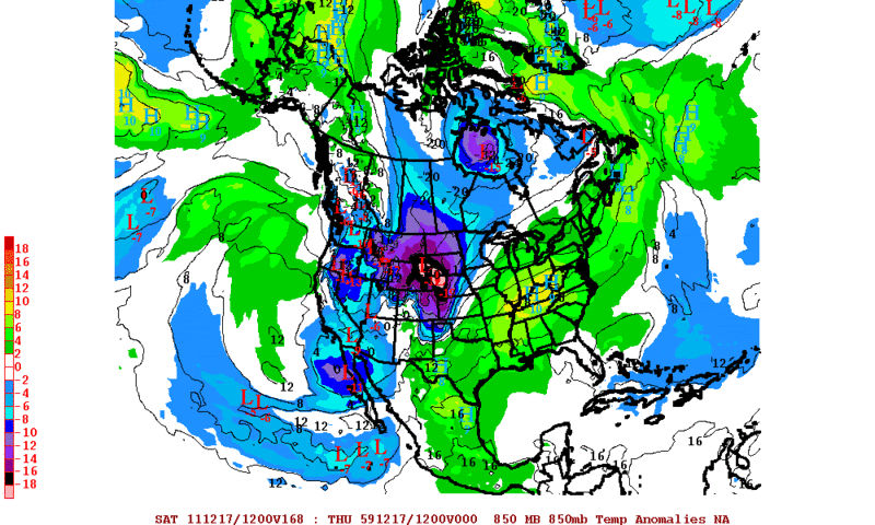
12z GFS ensembles very favorable. -EPO translating into a +PNA next week (High over eastern Canada/Southern Greenland as well ).

Uploaded with ImageShack.us

Uploaded with ImageShack.us

Uploaded with ImageShack.us

Uploaded with ImageShack.us
0 likes
The above post and any post by Ntxw is NOT an official forecast and should not be used as such. It is just the opinion of the poster and may or may not be backed by sound meteorological data. It is NOT endorsed by any professional institution including Storm2k. For official information, please refer to NWS products.
Help support Storm2K!
Help support Storm2K!
-
Rgv20

- S2K Supporter

- Posts: 2466
- Age: 39
- Joined: Wed Jan 05, 2011 5:42 pm
- Location: Edinburg/McAllen Tx
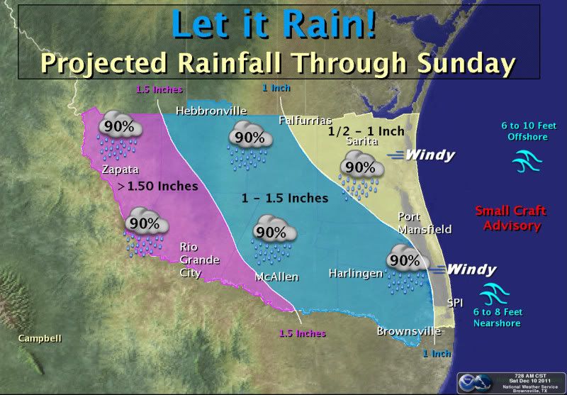
You know we are in a serious drought when we get a Special Weather Statement informing the public of 1/2'' to an 1'' rain event for the weekend  I think the 1 to 2 inches totals are going to be confined to the immediate coastline if at all. I'm just glad I have a good chance of seeing some rain!!
Special Weather Statement
SPECIAL WEATHER STATEMENT
NATIONAL WEATHER SERVICE BROWNSVILLE TX
218 PM CST FRI DEC 9 2011
TXZ248>257-100400-
ZAPATA-JIM HOGG-BROOKS-KENEDY-STARR-HIDALGO-INLAND WILLACY-
INLAND CAMERON-COASTAL WILLACY-COASTAL CAMERON-
INCLUDING THE CITIES OF...ZAPATA...HEBBRONVILLE...FALFURRIAS...
SARITA...RIO GRANDE CITY...ROMA...MCALLEN...EDINBURG...PHARR...
MISSION...WESLACO...RAYMONDVILLE...BROWNSVILLE...HARLINGEN...
PORT MANSFIELD...PORT ISABEL...SOUTH PADRE ISLAND...
LAGUNA HEIGHTS...LAGUNA VISTA
218 PM CST FRI DEC 9 2011
...WELCOME RAINS EXPECTED ACROSS DEEP SOUTH TEXAS THIS WEEKEND...
THE COMBINATION OF A SERIES OF UPPER LEVEL DISTURBANCES MOVING
OVER SOUTH TEXAS AND NORTHERN MEXICO...A SURFACE TROUGH OF LOW
PRESSURE DEVELOPING ALONG THE LOWER TEXAS COASTLINE AND GULF
MOISTURE MOVING IN OVER THE REGION WILL RESULT IN WELCOME RAINFALL
TO DEEP SOUTH TEXAS AND NORTHEASTERN MEXICO THIS WEEKEND.
AT THIS TIME WIDESPREAD LIGHT TO MODERATE RAINFALL AMOUNTS WILL
PRODUCE WEEKEND RAINFALL TOTALS FROM ONE HALF TO ONE INCH ACROSS
MOST OF DEEP SOUTH TEXAS THROUGH SUNDAY NIGHT. SOME LOCATIONS COULD
SEE ISOLATED HEAVIER TOTALS RANGING FROM ONE TO TWO INCHES THROUGH
SUNDAY NIGHT.
THE RAIN CHANCES WILL THEN START TO DIMINISH NEXT MONDAY AS MID
LEVEL RIDGING BUILDS INTO THE REGION PUSHING THE DEEPER MOISTURE
VALUES NORTH.
&&
FOR ALL YOUR LOCAL WEATHER NEEDS...GO TO OUR WEBSITE AT
HTTP://WEATHER.GOV/RGV.
$$
SPEECE
0 likes
The following post is NOT an official forecast and should not be used as such. It is just the opinion of the poster and may or may not be backed by sound meteorological data. It is NOT endorsed by any professional institution including storm2k.org For Official Information please refer to the NHC and NWS products.
Re: Texas Winter 2011-2012...
Ok so the 18z GFS is howling the same set up. For two days now the GFS runs have had an interesting storm in over Texas next weekend in one form or another. I'd increase the chances at this range to 20% optimistic, up from 2%
0 likes
The above post and any post by Ntxw is NOT an official forecast and should not be used as such. It is just the opinion of the poster and may or may not be backed by sound meteorological data. It is NOT endorsed by any professional institution including Storm2k. For official information, please refer to NWS products.
Help support Storm2K!
Help support Storm2K!
-
orangeblood
- S2K Supporter
- Posts: 3895
- Joined: Tue Dec 15, 2009 6:14 pm
- Location: Fort Worth, TX
Re: Texas Winter 2011-2012...
Ntxw wrote:Ok so the 18z GFS is howling the same set up. For two days now the GFS runs have had an interesting storm in over Texas next weekend in one form or another. I'd increase the chances at this range to 20% optimistic, up from 2%
I'll also add that the with the EPO in the negative phase, the GFS seems like the more plausible scenario when compared to the Euro or Canadian. Due to the fact that the negative phase of the EPO usually translates into a more progressive pattern from west to east across the country and usually doesn't let cut-off low pressure systems form and spin across the southwest US for too long. I would expect the Euro and Canadian to trend more towards the GFS over the next few days, imo.
0 likes
-
Rgv20
- S2K Supporter
- Posts: 2466
- Age: 39
- Joined: Wed Jan 05, 2011 5:42 pm
- Location: Edinburg/McAllen Tx
We have had a moderate rain for the past couple of hours!  According at the local site in Rio Grande City we already received 1.21'' of rain so far!! And it still coming down at a pretty good clip...
0 likes
The following post is NOT an official forecast and should not be used as such. It is just the opinion of the poster and may or may not be backed by sound meteorological data. It is NOT endorsed by any professional institution including storm2k.org For Official Information please refer to the NHC and NWS products.
-
South Texas Storms

- Professional-Met

- Posts: 4261
- Joined: Thu Jun 24, 2010 12:28 am
- Location: Houston, TX
Re: Texas Winter 2011-2012...
Enjoy it Rgv! You deserve it! Thankfully, the rains are spreading northward towards SA right now!
0 likes
The models are converging in a late week/weekend significant cold snap for the southern plains. Canadian and Euro look colder than previous runs. GFS backed off a bit on the cold a bit but still has the changes. West coast ridge shoots up into the Arctic circle so let's wait and see how they continue to trend.
0 likes
The above post and any post by Ntxw is NOT an official forecast and should not be used as such. It is just the opinion of the poster and may or may not be backed by sound meteorological data. It is NOT endorsed by any professional institution including Storm2k. For official information, please refer to NWS products.
Help support Storm2K!
Help support Storm2K!
-
Rgv20
- S2K Supporter
- Posts: 2466
- Age: 39
- Joined: Wed Jan 05, 2011 5:42 pm
- Location: Edinburg/McAllen Tx

South Texas Storms wrote::uarrow:
Enjoy it Rgv! You deserve it! Thankfully, the rains are spreading northward towards SA right now!
I'm definitely enjoying the Rain!
0 likes
The following post is NOT an official forecast and should not be used as such. It is just the opinion of the poster and may or may not be backed by sound meteorological data. It is NOT endorsed by any professional institution including storm2k.org For Official Information please refer to the NHC and NWS products.
-
vbhoutex

- Storm2k Executive

- Posts: 29150
- Age: 74
- Joined: Wed Oct 09, 2002 11:31 pm
- Location: Cypress, TX
- Contact:
Re: Texas Winter 2011-2012...
South Texas Storms wrote::uarrow:
Enjoy it Rgv! You deserve it! Thankfully, the rains are spreading northward towards SA right now!
Looks like they have made it to SA. They are closer than I expected to our West here in Houston. I am hoping ALL of us get some of this rain. As regular as the rains have gotten we are still over 2 feet down for our deficit. The weird thing is that our yards are greener now than they have been in the last 6 months and they are now in their dormant stage.
0 likes
Skywarn, C.E.R.T.
Please click below to donate to STORM2K to help with the expenses of keeping the site going:

Please click below to donate to STORM2K to help with the expenses of keeping the site going:

A quote from the Austin wfo discussion, "A STRONGER CANADIAN FRONT IS
EXPECTED ON FRIDAY. JUST BEYOND THIS FORECAST...NEXT
WEEKEND...SOME MODELS BRING ANOTHER UPPER LEVEL TROUGH TO CREATE
CHANCES OF OVERRUNNING RAINS."
Seems whatever may happen about a week out has caught their attention.
EXPECTED ON FRIDAY. JUST BEYOND THIS FORECAST...NEXT
WEEKEND...SOME MODELS BRING ANOTHER UPPER LEVEL TROUGH TO CREATE
CHANCES OF OVERRUNNING RAINS."
Seems whatever may happen about a week out has caught their attention.
0 likes
Any opinions stated are those of an amateur, please take with several grains of salt and for official forecast refer to the National Weather Service.
-
Portastorm

- Storm2k Moderator

- Posts: 9955
- Age: 63
- Joined: Fri Jul 11, 2003 9:16 am
- Location: Round Rock, TX
- Contact:
Re: Texas Winter 2011-2012...
Based on the 12z medium-range models, I think Ntxw is definitely onto something. Props to orangeblood as well for his post last night. Next weekend looks to be a wild one in Texas with wintry weather for some and severe weather for others.
They don't make La Ninas like they used to.
They don't make La Ninas like they used to.
0 likes
Any forecasts under my name are to be taken with a grain of salt. Get your best forecasts from the National Weather Service and National Hurricane Center.
-
Tireman4

- S2K Supporter
- Posts: 5904
- Age: 60
- Joined: Fri Jun 30, 2006 1:08 pm
- Location: Humble, Texas
- Contact:
Re: Texas Winter 2011-2012...
They don't make La Ninas like they used to. [/quote]
Oh how we long for the old days.....Up with the PWC...
Oh how we long for the old days.....Up with the PWC...
0 likes
Re: Texas Winter 2011-2012...
Wait and see approach from FW
THERE IS GOOD AGREEMENT AMONG THE MODELS WITH THE SYNOPTIC UPPER
LEVEL PATTERN AT 144 HRS. A LARGE/BROAD POSITIVE TILTED 200MB
TROUGH EXISTS FROM THE HUDSON BAY TO LAS VEGAS. THE 500 MB TROUGH
IS ANCHORED BY A SLOW MOVING UPPER LEVEL LOW OVER THE SW US...WITH
THE NORTHERN PART OF THE 500MB TROUGH DETACHED AND PROGRESSIVE
ACROSS THE NORTHERN PLAINS. THIS UPPER PATTERN RAISES RED FLAGS
FOR THE POTENTIAL OF WINTER WEATHER...BECAUSE IT SIGNALS THAT MAIN
INGREDIENTS...COLD AIR AND LIFT...WILL BE GIVEN THE CHANCE TO
MINGLE IN OUR REGION. MODELS BECOME UNTRUSTWORTHY REGARDING THE
SPECIFICS BY DAY 7-10...AND WE HAVE SEEN THE GFS BOUNCE AROUND
WITH ITS HANDLING OF THE WESTERN LOW. THE NORTHERN PIECE OF THE
TROUGH IS NOT QUITE AS STRONG/DEFINED AS I WOULD LIKE TO SEE...SO
THIS SUGGESTS COLD AIR MAY BE THE LIMITING FACTOR FOR ANY WINTER
WEATHER. THIS LIKELY SIGNALS MORE ICE THAN SNOW...WITH THE NW PART
OF THE CWA FAVORED SOMETIME BETWEEN SATURDAY AND NEXT MONDAY.
OBVIOUSLY WITHOUT GOOD MODEL CONSISTENCY AT THIS TIME RANGE WILL
KEEP FORECAST ALL RAIN SATURDAY AND CONTINUE TO WATCH.
0 likes
The above post and any post by Ntxw is NOT an official forecast and should not be used as such. It is just the opinion of the poster and may or may not be backed by sound meteorological data. It is NOT endorsed by any professional institution including Storm2k. For official information, please refer to NWS products.
Help support Storm2K!
Help support Storm2K!

Re: Texas Winter 2011-2012...
I haven't had a lot of time to look at the models (horrible weekend) but if I was a betting man, I'd go with ice storm over snow storm on this one.
0 likes
-
Brandon8181
- S2K Supporter
- Posts: 431
- Age: 42
- Joined: Tue Jan 04, 2011 4:52 pm
- Location: Tyler, TX
- Contact:
Re: Texas Winter 2011-2012...
Looks like the GFS has backed off big time with any winter weather potential across Texas.. Maybe its just a fluke run.. you think?
Considering the consistancy that we have seen over the last few days...
Considering the consistancy that we have seen over the last few days...
0 likes
I am not a meteorologist. Any post from me should be taken as hobby or fun educational information, but not an accurate source for weather information. Please, refer to your local weather station or National Weather Service for the most up to date information. 
Re: Texas Winter 2011-2012...
Brandon8181 wrote:Looks like the GFS has backed off big time with any winter weather potential across Texas.. Maybe its just a fluke run.. you think?
Considering the consistancy that we have seen over the last few days...
The 18z run of the gfs is probably the least reliable of all the runs, probably need to wait and see what the next runs show.
0 likes
Any opinions stated are those of an amateur, please take with several grains of salt and for official forecast refer to the National Weather Service.

Re: Texas Winter 2011-2012...
that precip shield is getting really close to dfw area with lows expected to be in the low 30s
0 likes
Who is online
Users browsing this forum: No registered users and 111 guests