
Though I must say, GFS is the warmest member of it's ensembles which are colder and stormier
Texas Winter 2011-2012...
Moderator: S2k Moderators
Forum rules
 The posts in this forum are NOT official forecast and should not be used as such. They are just the opinion of the poster and may or may not be backed by sound meteorological data. They are NOT endorsed by any professional institution or STORM2K.

The posts in this forum are NOT official forecast and should not be used as such. They are just the opinion of the poster and may or may not be backed by sound meteorological data. They are NOT endorsed by any professional institution or STORM2K.
It's the usual model fun and games  today the GFS flipped to warmer (much much warmer, borderline torch) while the Euro and Canadian flip to colder. Would we have it any other way?
  0z is definitely warmer.
Though I must say, GFS is the warmest member of it's ensembles which are colder and stormier
Though I must say, GFS is the warmest member of it's ensembles which are colder and stormier
0 likes
The above post and any post by Ntxw is NOT an official forecast and should not be used as such. It is just the opinion of the poster and may or may not be backed by sound meteorological data. It is NOT endorsed by any professional institution including Storm2k. For official information, please refer to NWS products.
Help support Storm2K!
-
Rgv20

- S2K Supporter

- Posts: 2466
- Age: 39
- Joined: Wed Jan 05, 2011 5:42 pm
- Location: Edinburg/McAllen Tx
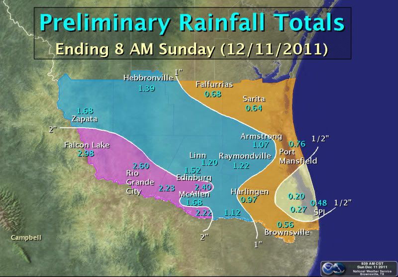
On a side note, today we received 2.53'' of Rain!! That is pretty impressive for December!
0 likes
The following post is NOT an official forecast and should not be used as such. It is just the opinion of the poster and may or may not be backed by sound meteorological data. It is NOT endorsed by any professional institution including storm2k.org For Official Information please refer to the NHC and NWS products.
-
Portastorm

- Storm2k Moderator

- Posts: 9955
- Age: 63
- Joined: Fri Jul 11, 2003 9:16 am
- Location: Round Rock, TX
- Contact:
Re: Texas Winter 2011-2012...
Sunday morning thoughts from the Portastorm Weather Center prior to church:
* The operational runs of the GFS/Euro/Canadian for next weekend and beyond seem to have backed off some of the more "exciting" scenarios painted out yesterday. But winter weather fans shouldn't be bummed as the operational runs for all models have struggled this season beyond the five-day period. In other words, don't get too worked up over a single series change. The 12z runs could quite possibly go back to the "colder" scenarios.
* It should also be noted that the ensembles for the GFS/Euro/Canadian all look "colder" next weekend than the operational runs. Some of you may be wondering what the difference is. The ensembles are a number of computer model runs (run at the same time) that slightly change factors/algorithims and, thus, see slightly different outcomes. I’m not entirely sure how it works, but then the models pick a scenario most likely from all of the ensemble runs. So … you may see a 0z GFS run which shows a snowstorm for Dallas, per se, which is a operational run. Yet, of the 24 options run for the 0z cycle, maybe 15 of them show rain (or nothing) for Dallas. Sometimes it behooves weather fans to not only look at the operational run but the ensembles as well.
* That being said, I'm reading some encouraging things (encouraging if you like winter) about what lies ahead 2-3 weeks or so. Joe Bastardi (of WeatherBell) sees a pattern change and possible dump of very cold air close to Christmas. Larry Cosgrove sees a similar possibility and even mentions the possibility of the Polar Vortex relocating close to Hudson Bay by around Christmas. The Polar Vortex is a major generator of winter weather and if it is close to Hudson Bay that means it could pull down some Arctic air into the Plains and lower 48. David Tolleris of Wxrisk.com mentions the possibility of a stratospheric warming event. These are precursors to major cold plunges of air into the lower 48.
* All in all, an active pattern continues and there definitely could be some real excitement for winter weather in Texas in the days/weeks ahead.
0 likes
Any forecasts under my name are to be taken with a grain of salt. Get your best forecasts from the National Weather Service and National Hurricane Center.
-
orangeblood
- S2K Supporter
- Posts: 3895
- Joined: Tue Dec 15, 2009 6:14 pm
- Location: Fort Worth, TX
Re: Texas Winter 2011-2012...
With true arctic high pressure coming into the lower 48 this week and split flow, this setup next weekend looks like it has the potential for a serious overrunning ice event for someone in the southern plains. Too early to tell exactly where at this time though but one thing we do know...it's a very difficult forecast!!
0 likes
Re: Texas Winter 2011-2012...
orangeblood wrote:With true arctic high pressure coming into the lower 48 this week and split flow, this setup next weekend looks like it has the potential for a serious overrunning ice event for someone in the southern plains. Too early to tell exactly where at this time though but one thing we do know...it's a very difficult forecast!!
The SSW event you posted awhile back is about to head into full gear down the road if the GFS is right over Siberia/North Pacific. Looks like it might be just a matter of time before North America sees a significant/severe cold snap. As Srainhoutx used to say, stepping down. We might be taking our first big steps this week.
This week is going to be very wet for Texas. Wintry mess or not, severe weather or not the models are depicting A LOT of rain.
0 likes
The above post and any post by Ntxw is NOT an official forecast and should not be used as such. It is just the opinion of the poster and may or may not be backed by sound meteorological data. It is NOT endorsed by any professional institution including Storm2k. For official information, please refer to NWS products.
Help support Storm2K!
Help support Storm2K!
-
Rgv20
- S2K Supporter
- Posts: 2466
- Age: 39
- Joined: Wed Jan 05, 2011 5:42 pm
- Location: Edinburg/McAllen Tx
Re: Texas Winter 2011-2012...
Portastorm wrote:Sunday morning thoughts from the Portastorm Weather Center prior to church:
* That being said, I'm reading some encouraging things (encouraging if you like winter) about what lies ahead 2-3 weeks or so. Joe Bastardi (of WeatherBell) sees a pattern change and possible dump of very cold air close to Christmas. Larry Cosgrove sees a similar possibility and even mentions the possibility of the Polar Vortex relocating close to Hudson Bay by around Christmas. The Polar Vortex is a major generator of winter weather and if it is close to Hudson Bay that means it could pull down some Arctic air into the Plains and lower 48. David Tolleris of Wxrisk.com mentions the possibility of a stratospheric warming event. These are precursors to major cold plunges of air into the lower 48.
* All in all, an active pattern continues and there definitely could be some real excitement for winter weather in Texas in the days/weeks ahead.
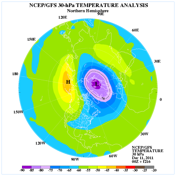
This morning I was looking at the forecast temperatures of the Stratosphere and indeed the 0zGFS Ensembles forecast warming to take place in Western Canada and Alaska at 30mb level starting 5 to 6 days from now but becoming more pronounced around 9 days from now. My hunch is that we may be tracking a fairly strong Arctic front round the week after Christmas.
Current temperatures in the Stratosphere are relatively cool NW Canada.
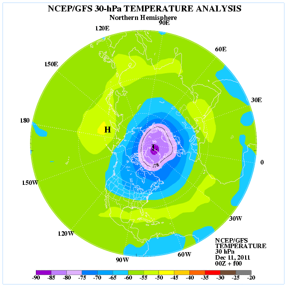
Now take a look at the bright color in NW Canada which indicate a warming trend on the Stratosphere by Day 9.
0 likes
The following post is NOT an official forecast and should not be used as such. It is just the opinion of the poster and may or may not be backed by sound meteorological data. It is NOT endorsed by any professional institution including storm2k.org For Official Information please refer to the NHC and NWS products.
-
orangeblood
- S2K Supporter
- Posts: 3895
- Joined: Tue Dec 15, 2009 6:14 pm
- Location: Fort Worth, TX
Re: Texas Winter 2011-2012...
Over 75% of the 18Z GFS ensemble members show some sort of winter storm tracking across Texas next weekend. I would suspect the operational to follow suit either tonight or sometime tomorrow.
The following post is NOT an official forecast and should not be used as such. It is just the opinion of the poster and may or may not be backed by sound meteorological data. It is NOT endorsed by any professional institution including storm2k.org. For official information, please refer to NWS products.]
The following post is NOT an official forecast and should not be used as such. It is just the opinion of the poster and may or may not be backed by sound meteorological data. It is NOT endorsed by any professional institution including storm2k.org. For official information, please refer to NWS products.]
0 likes
Re: Texas Winter 2011-2012...
orangeblood wrote:Over 75% of the 18Z GFS ensemble members show some sort of winter storm tracking across Texas next weekend. I would suspect the operational to follow suit either tonight or sometime tomorrow.
The ensembles have not budged since the GFS first showed it last week. I think this may be a classic case where the OP's medium range flaws have kicked in, losing storms/cold in the medium range and bringing them back in the end. Big red flag when the Op's is so different from the ensemble means.
Last edited by Ntxw on Sun Dec 11, 2011 9:10 pm, edited 1 time in total.
0 likes
The above post and any post by Ntxw is NOT an official forecast and should not be used as such. It is just the opinion of the poster and may or may not be backed by sound meteorological data. It is NOT endorsed by any professional institution including Storm2k. For official information, please refer to NWS products.
Help support Storm2K!
Help support Storm2K!
Re: Texas Winter 2011-2012...
Ntxw wrote:orangeblood wrote:Over 75% of the 18Z GFS ensemble members show some sort of winter storm tracking across Texas next weekend. I would suspect the operational to follow suit either tonight or sometime tomorrow.
The ensembles have not budged since the GFS first showed it last week. I think this may be a classic case where the OP's medium range flaws have kicked in, losing storms/cold in the medium range and bringing them back in the end. Big red flag when the Op's is so different from the ensembles.
How much of Tx do the ensembles show affected by the storm?
0 likes
Any opinions stated are those of an amateur, please take with several grains of salt and for official forecast refer to the National Weather Service.
-
Rgv20
- S2K Supporter
- Posts: 2466
- Age: 39
- Joined: Wed Jan 05, 2011 5:42 pm
- Location: Edinburg/McAllen Tx
I almost forgotten what rain looked like!!
000
NOUS44 KBRO 111722 AAB
PNSBRO
TXZ248>257-120500-
PUBLIC INFORMATION STATEMENT...UPDATED
NATIONAL WEATHER SERVICE BROWNSVILLE TX
1122 AM CST SUN DEC 11 2011
...FIRST WIDESPREAD RAINS IN NEARLY A YEAR SOAK THE VALLEY...
A SERIES OF MID AND UPPER LEVEL DISTURBANCES COMBINED WITH A LOW
PRESSURE TROUGH ALONG THE LOWER TEXAS COAST TO LIFT MOISTURE INTO
SIGNIFICANT RAINS FROM THE RIO GRANDE VALLEY TO THE RANCHLANDS OF
ZAPATA...JIM HOGG...BROOKS...AND KENEDY COUNTY. EVENT TOTALS AS OF
8 AM DECEMBER 11TH RANGED FROM AROUND ONE HALF INCH NEAR THE CAMERON
COUNTY COAST TO MORE THAN 2 INCHES FROM HIDALGO TO ZAPATA COUNTY.
FOR LOCATIONS IN WESTERN HIDALGO AND EASTERN STARR COUNTY...THE
TWO DAY RAINFALL DECEMBER 10TH AND 11TH WAS NEARLY 50 PERCENT OF THE TOTAL
RAINFALL OBSERVED DURING THE PRIOR FOURTEEN MONTHS!
http://forecast.weather.gov/product.php?site=BRO&issuedby=BRO&product=PNS&format=CI&version=1&glossary=1
0 likes
The following post is NOT an official forecast and should not be used as such. It is just the opinion of the poster and may or may not be backed by sound meteorological data. It is NOT endorsed by any professional institution including storm2k.org For Official Information please refer to the NHC and NWS products.
-
TeamPlayersBlue

- Category 5

- Posts: 3533
- Joined: Tue Feb 02, 2010 1:44 am
- Location: Denver/Applewood, CO
LC is hinting at a SSW event occurring in his weather update.Next couple weeks could be interesting
0 likes
Personal Forecast Disclaimer:
The posts in this forum are NOT official forecast and should not be used as such. They are just the opinion of the poster and may or may not be backed by sound meteorological data. They are NOT endorsed by any professional institution or storm2k.org. For official information, please refer to the NHC and NWS products.
The posts in this forum are NOT official forecast and should not be used as such. They are just the opinion of the poster and may or may not be backed by sound meteorological data. They are NOT endorsed by any professional institution or storm2k.org. For official information, please refer to the NHC and NWS products.
-
GRAYSONCO.WX
- Category 1

- Posts: 450
- Joined: Thu Jan 06, 2011 4:29 pm
- Location: Denison, Texas
Re: Texas Winter 2011-2012...
Right now it looks like the 00Z GFS has cooler air moving further south at hr 102 through108.
0 likes
-
orangeblood
- S2K Supporter
- Posts: 3895
- Joined: Tue Dec 15, 2009 6:14 pm
- Location: Fort Worth, TX
Re: Texas Winter 2011-2012...
GRAYSONCO.WX wrote:Right now it looks like the 00Z GFS has cooler air moving further south at hr 102 through108.
We see this every winter with these models...it takes them awhile to catch on to the shallow artic air pressing south and Sometimes don't even pick up on it until the day of. Also, for some reason the operational's arctic high isn't near as strong as most of it's ensemble members for this weekend.
0 likes
-
GRAYSONCO.WX
- Category 1
- Posts: 450
- Joined: Thu Jan 06, 2011 4:29 pm
- Location: Denison, Texas
Re: Texas Winter 2011-2012...
orangeblood wrote:GRAYSONCO.WX wrote:Right now it looks like the 00Z GFS has cooler air moving further south at hr 102 through108.
We see this every winter with these models...it takes them awhile to catch on to the shallow artic air pressing south and Sometimes don't even pick up on it until the day of. Also, for some reason the operational's arctic high isn't near as strong as most of it's ensemble members for this weekend.
So are you thinking a possible winter storm?
0 likes
-
Brandon8181
- S2K Supporter
- Posts: 431
- Age: 42
- Joined: Tue Jan 04, 2011 4:52 pm
- Location: Tyler, TX
- Contact:
Re: Texas Winter 2011-2012...
What a good place to go to see all of the ensemble members???
0 likes
I am not a meteorologist. Any post from me should be taken as hobby or fun educational information, but not an accurate source for weather information. Please, refer to your local weather station or National Weather Service for the most up to date information. 
Re: Texas Winter 2011-2012...
Brandon8181 wrote:What a good place to go to see all of the ensemble members???
Allan Huffman has a great site for all of your weather model needs! Ensembles are on the right.
http://raleighwx.americanwx.com/models.html
PSU also has a weather page that's quite handy.
http://www.meteo.psu.edu/~gadomski/ewall.html
0 likes
The above post and any post by Ntxw is NOT an official forecast and should not be used as such. It is just the opinion of the poster and may or may not be backed by sound meteorological data. It is NOT endorsed by any professional institution including Storm2k. For official information, please refer to NWS products.
Help support Storm2K!
Help support Storm2K!
Re: Texas Winter 2011-2012...
Ok after extensive studying of models/teleconnections/analogs I'm going to put out a bold (personal) prediction. Reading many thoughts from people much much better than me at weather, I am going out on a limb (with some support from the OP's today especially the euro) and say there will be a winter storm with ice/snow or both for Texas and not just the panhandle or far west Texas within the next week to week and a half. The storm train is rolling and my gut feeling is it's only a matter of time before the blind squirrel finds a nut (cold air) whether it be arctic intrusion or dynamic cooling! Please read the disclaimer on my siggy before taking anything I say seriously!

Uploaded with ImageShack.us

Uploaded with ImageShack.us
0 likes
The above post and any post by Ntxw is NOT an official forecast and should not be used as such. It is just the opinion of the poster and may or may not be backed by sound meteorological data. It is NOT endorsed by any professional institution including Storm2k. For official information, please refer to NWS products.
Help support Storm2K!
Help support Storm2K!
-
Brandon8181
- S2K Supporter
- Posts: 431
- Age: 42
- Joined: Tue Jan 04, 2011 4:52 pm
- Location: Tyler, TX
- Contact:
Re: Texas Winter 2011-2012...
Which of the colors is 32/0 degress?
0 likes
I am not a meteorologist. Any post from me should be taken as hobby or fun educational information, but not an accurate source for weather information. Please, refer to your local weather station or National Weather Service for the most up to date information.
-
wxman57

- Moderator-Pro Met

- Posts: 23175
- Age: 68
- Joined: Sat Jun 21, 2003 8:06 pm
- Location: Houston, TX (southwest)
Re: Texas Winter 2011-2012...
Ntxw wrote:Ok after extensive studying of models/teleconnections/analogs I'm going to put out a bold (personal) prediction. Reading many thoughts from people much much better than me at weather, I am going out on a limb (with some support from the OP's today especially the euro) and say there will be a winter storm with ice/snow or both for Texas and not just the panhandle or far west Texas within the next week to week and a half. The storm train is rolling and my gut feeling is it's only a matter of time before the blind squirrel finds a nut (cold air)
What's currently missing is the cold air. There isn't much in western Canada now, and not much change is forecast for at least the next 10-12 days. In fact, temps in western and central Canada are forecast to remain somewhat above normal for the next few weeks. There are indications of cold air building in Canada toward the end of December, however. Without some influx of cold air it will be hard to get snow south of the Panhandle/W. TX.
0 likes
^ Thanks for the input Wxman! I do realize the lack of true arctic air. I guess my thought is maybe one of these SW disturbances might hold together strong enough to generate marginally cold enough air as many during el-nino like storms with lack of the aforementioned. How's your experience so far this winter without the 100s you've been so accustomed to the past summer? Seems just like yesterday...
0 likes
The above post and any post by Ntxw is NOT an official forecast and should not be used as such. It is just the opinion of the poster and may or may not be backed by sound meteorological data. It is NOT endorsed by any professional institution including Storm2k. For official information, please refer to NWS products.
Help support Storm2K!
Help support Storm2K!
Who is online
Users browsing this forum: No registered users and 180 guests