
I've gone through an entire chapstick since last night. My lips are just not tuned into these low dewpoints especially after the moisture rich cloudy days we've had this winter!
Texas Winter 2011-2012...
Moderator: S2k Moderators
Forum rules
 The posts in this forum are NOT official forecast and should not be used as such. They are just the opinion of the poster and may or may not be backed by sound meteorological data. They are NOT endorsed by any professional institution or STORM2K.

The posts in this forum are NOT official forecast and should not be used as such. They are just the opinion of the poster and may or may not be backed by sound meteorological data. They are NOT endorsed by any professional institution or STORM2K.
I refuse to give up on winter until February passes, that is our month period!  Even the 2008-2009 (worst winter for me) had one cold snap with ice at least. Ain't over till the fat lady sings
I've gone through an entire chapstick since last night. My lips are just not tuned into these low dewpoints especially after the moisture rich cloudy days we've had this winter!
I've gone through an entire chapstick since last night. My lips are just not tuned into these low dewpoints especially after the moisture rich cloudy days we've had this winter!
0 likes
The above post and any post by Ntxw is NOT an official forecast and should not be used as such. It is just the opinion of the poster and may or may not be backed by sound meteorological data. It is NOT endorsed by any professional institution including Storm2k. For official information, please refer to NWS products.
Help support Storm2K!
-
Rgv20

- S2K Supporter

- Posts: 2466
- Age: 39
- Joined: Wed Jan 05, 2011 5:42 pm
- Location: Edinburg/McAllen Tx
FWIW the Monthly Forecast ECMWF is showing more frequent cold air intrusions to Texas by late month until the early part of February. Meanwhile tho the CFS is in complete opposite with the Euro as it is showing very very warm temperatures for the US and Canada during this same time frame.
CFS forecast for Wk3 (26Jan-1Feb) and Wk4 (2Feb-8Feb)
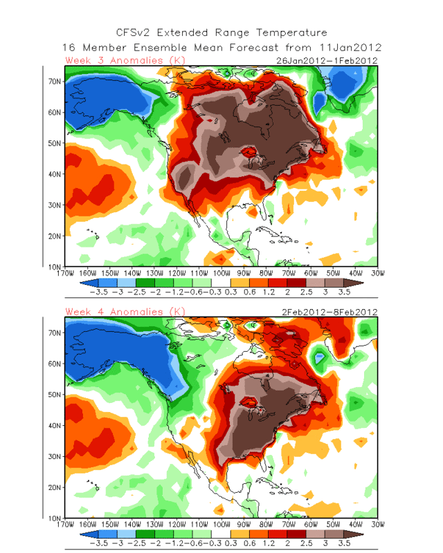
CFS forecast for Wk3 (26Jan-1Feb) and Wk4 (2Feb-8Feb)
0 likes
The following post is NOT an official forecast and should not be used as such. It is just the opinion of the poster and may or may not be backed by sound meteorological data. It is NOT endorsed by any professional institution including storm2k.org For Official Information please refer to the NHC and NWS products.

Re: Texas Winter 2011-2012...
Portastorm wrote:In what I would file under the "For What It's Worth" category, both Larry Cosgrove and David Tolleris have publicly written in Facebook posts in the last 24-36 hours that they believe winter is basically over for most of the lower 48 and they see no signs of the pattern ahead changing to please winter weather fans.
This is not to create a referendum on the qualities of either meteorologist ... just sharing a statement of fact. For the record, I hope they're wrong. But you knew that!
Wasn't it just about a week or so ago that Larry Cosgrove was predicting a cold ending to January and start to Feb?
0 likes
Any forecast I make is based on my opinion only. Please refer to the NWS or NHC for official forecasts.
-
TeamPlayersBlue

- Category 5

- Posts: 3524
- Joined: Tue Feb 02, 2010 1:44 am
- Location: Denver/Applewood, CO
I know JB says the global avg sea ice is above normal right now, but with all the cold air staying near the pole and northern latitudes, shouldnt we be almost to normal sea ice in the NH? Seems were still pretty low.
As far as our winter, remember when it snowed in East Texas in April? Still too early guys. I think this winter will be typical of what we had in the 90's, but the last few winters has spoiled us. Im willing to sacrifice one winter as long as the next couple are as brutal as some of our previous years
As far as our winter, remember when it snowed in East Texas in April? Still too early guys. I think this winter will be typical of what we had in the 90's, but the last few winters has spoiled us. Im willing to sacrifice one winter as long as the next couple are as brutal as some of our previous years
0 likes
Personal Forecast Disclaimer:
The posts in this forum are NOT official forecast and should not be used as such. They are just the opinion of the poster and may or may not be backed by sound meteorological data. They are NOT endorsed by any professional institution or storm2k.org. For official information, please refer to the NHC and NWS products.
The posts in this forum are NOT official forecast and should not be used as such. They are just the opinion of the poster and may or may not be backed by sound meteorological data. They are NOT endorsed by any professional institution or storm2k.org. For official information, please refer to the NHC and NWS products.
-
Texas Snowman

- Storm2k Moderator

- Posts: 6197
- Joined: Fri Jan 25, 2008 11:29 am
- Location: Denison, Texas
Re: Texas Winter 2011-2012...
Snowman67 wrote:Wasn't it just about a week or so ago that Larry Cosgrove was predicting a cold ending to January and start to Feb?
Yes, but I think to be fair, he did indicate that he believed there was going to be a big storm that would come out of the west and change the upper level air patterns. That hasn't happened yet and he began to say a week or so ago that he thought it had to happen before the cold air could be delivered southward.
A few things to keep in mind:
1. Tremendous snowcover and record cold is building in Alaska - hopefully that will extend eastward into Canada.
2. We're still less than one month into official winter.
3. Models are struggling seeing things correctly even from a few days away.
4. We've got the rest of January, all of February, and the first week or two of March to have some winter fun in Texas.
5. This is an almost unprecedented La Nina winter (drought denting rains in much of Texas?!? Record snows in Midland?!? Almost no snow at all up north?!? And until today, Midland had more seasonal snow than Minneapolis, Chicago, and Buffalo combined!!! So who knows what the rest of this winter holds?).
6. And the big lady who will sing isn't even in the building yet as far as winter being over.
That's my .02 cents and I'm sticking to it!

0 likes
The above post and any post by Texas Snowman is NOT an official forecast and should not be used as such. It is just the opinion of the poster and may or may not be backed by sound meteorological data. It is NOT endorsed by any professional institution including storm2k.org. For official information, please refer to NWS products.
-
orangeblood
- S2K Supporter
- Posts: 3895
- Joined: Tue Dec 15, 2009 6:14 pm
- Location: Fort Worth, TX
Re: Texas Winter 2011-2012...
Wow!! That is one extremely strong Pacific Jet forecast over the next 10-15 days...it just overwhelms any system coming down from the Arctic. Looks like the block formed too far north/west and I wouldn't expect any fun and games until that jet dies down.
0 likes
-
Portastorm

- Storm2k Moderator
- Posts: 9954
- Age: 63
- Joined: Fri Jul 11, 2003 9:16 am
- Location: Round Rock, TX
- Contact:
Re: Texas Winter 2011-2012...
orangeblood wrote:Wow!! That is one extremely strong Pacific Jet forecast over the next 10-15 days...it just overwhelms any system coming down from the Arctic. Looks like the block formed too far north/west and I wouldn't expect any fun and games until that jet dies down.
That's for sure. As long as that "firehose" jet pounds the Pacific Northwest, it'll be zonal and mild for us in Texas. No "winter" to speak of whatsoever.
0 likes
Any forecasts under my name are to be taken with a grain of salt. Get your best forecasts from the National Weather Service and National Hurricane Center.
-
wxman57

- Moderator-Pro Met

- Posts: 23170
- Age: 68
- Joined: Sat Jun 21, 2003 8:06 pm
- Location: Houston, TX (southwest)
Re: Texas Winter 2011-2012...
Just checking the overnight model runs. All have temps from 5-20F above normal from the Dakotas south through Texas for most of the next 15 days. No real cold to speak of south of Canada. They also indicate warming temps after the next week across the Plains (up to 15-20F above normal). The cold air still hasn't built into western Canada, though the models forecast it to build there this weekend.
0 likes
-
aggiecutter
- Category 5
- Posts: 1755
- Joined: Thu Oct 14, 2004 9:22 pm
- Location: Texarkana
Re: Texas Winter 2011-2012...
It's definitely going to get cold in western Alberta. However, there are no indications that air is coming to the lower 48 anytime soon. BTW, GP is in west-central Alberta.
Grand Prairie, Alberta forecast:
http://www.timeanddate.com/weather/cana ... de-prairie
The preceding post is NOT an official forecast and should not be used as such. It is just the opinion of the poster and may or may not be backed by sound meteorological data. It is NOT endorsed by any professional institution including storm2k.org. For official information, please refer to NWS products.
0 likes
-
Portastorm
- Storm2k Moderator
- Posts: 9954
- Age: 63
- Joined: Fri Jul 11, 2003 9:16 am
- Location: Round Rock, TX
- Contact:
Re: Texas Winter 2011-2012...
wxman57 wrote:Just checking the overnight model runs. All have temps from 5-20F above normal from the Dakotas south through Texas for most of the next 15 days. No real cold to speak of south of Canada. They also indicate warming temps after the next week across the Plains (up to 15-20F above normal). The cold air still hasn't built into western Canada, though the models forecast it to build there this weekend.
Unfortunately you're correct, sir. I would write off the next 7-10 days for winter weather in our part of the CONUS. However, I do not trust the models (nor do you based on previous comments) beyond that period. You shall have your good cycling weather in the near term but the PWC is not giving up the (grey) ghost!
0 likes
Any forecasts under my name are to be taken with a grain of salt. Get your best forecasts from the National Weather Service and National Hurricane Center.
-
Rgv20
- S2K Supporter
- Posts: 2466
- Age: 39
- Joined: Wed Jan 05, 2011 5:42 pm
- Location: Edinburg/McAllen Tx
Got down to 31F at my backyard 
I can tolerate 100+ temperatures but as far as cold weather not so much....
I can tolerate 100+ temperatures but as far as cold weather not so much....
0 likes
The following post is NOT an official forecast and should not be used as such. It is just the opinion of the poster and may or may not be backed by sound meteorological data. It is NOT endorsed by any professional institution including storm2k.org For Official Information please refer to the NHC and NWS products.
-
wxman57
- Moderator-Pro Met
- Posts: 23170
- Age: 68
- Joined: Sat Jun 21, 2003 8:06 pm
- Location: Houston, TX (southwest)
Re: Texas Winter 2011-2012...
Portastorm wrote:wxman57 wrote:Just checking the overnight model runs. All have temps from 5-20F above normal from the Dakotas south through Texas for most of the next 15 days. No real cold to speak of south of Canada. They also indicate warming temps after the next week across the Plains (up to 15-20F above normal). The cold air still hasn't built into western Canada, though the models forecast it to build there this weekend.
Unfortunately you're correct, sir. I would write off the next 7-10 days for winter weather in our part of the CONUS. However, I do not trust the models (nor do you based on previous comments) beyond that period. You shall have your good cycling weather in the near term but the PWC is not giving up the (grey) ghost!
I don't trust the models beyond 3-4 days. However, I much prefer seeing them forecasting warm weather in the long range day in and day out than the opposite.
0 likes
-
aggiecutter
- Category 5
- Posts: 1755
- Joined: Thu Oct 14, 2004 9:22 pm
- Location: Texarkana
Re: Texas Winter 2011-2012...
The long range Mid January-March from HM. Scroll to bottom to see video.
http://www.accuweather.com/en/weather-b ... ntry/60229
http://www.accuweather.com/en/weather-b ... ntry/60229
0 likes
-
TeamPlayersBlue
- Category 5
- Posts: 3524
- Joined: Tue Feb 02, 2010 1:44 am
- Location: Denver/Applewood, CO
31.3F here in Sugar Land last night. Looks to be another beautiful day. If it isnt snowing, i dont mind temps above 65!
0 likes
Personal Forecast Disclaimer:
The posts in this forum are NOT official forecast and should not be used as such. They are just the opinion of the poster and may or may not be backed by sound meteorological data. They are NOT endorsed by any professional institution or storm2k.org. For official information, please refer to the NHC and NWS products.
The posts in this forum are NOT official forecast and should not be used as such. They are just the opinion of the poster and may or may not be backed by sound meteorological data. They are NOT endorsed by any professional institution or storm2k.org. For official information, please refer to the NHC and NWS products.
Re: Texas Winter 2011-2012...
It's not much, but there's a little bit more snow cover then say a week ago in the northern plains. Nothing substantial by any means. At least the GFS shows good snow cover developing a week+- from now after the active pacific jet kicks in, and more after that. For now we'll all have to join wxman biking

Uploaded with ImageShack.us

Uploaded with ImageShack.us
Edit: Looking at some stuff for the Pacific (this probably belongs in the tropics thread) it's getting warmer off the coast of South America. I'm betting on the return of El nino by next winter or at least a weak one. Summer might not be TOO hot!
Jan 2

Uploaded with ImageShack.us
Jan 12

Uploaded with ImageShack.us

Uploaded with ImageShack.us

Uploaded with ImageShack.us
Edit: Looking at some stuff for the Pacific (this probably belongs in the tropics thread) it's getting warmer off the coast of South America. I'm betting on the return of El nino by next winter or at least a weak one. Summer might not be TOO hot!
Jan 2

Uploaded with ImageShack.us
Jan 12

Uploaded with ImageShack.us
0 likes
The above post and any post by Ntxw is NOT an official forecast and should not be used as such. It is just the opinion of the poster and may or may not be backed by sound meteorological data. It is NOT endorsed by any professional institution including Storm2k. For official information, please refer to NWS products.
Help support Storm2K!
Help support Storm2K!

-
weatherdude1108
- Category 5
- Posts: 4228
- Joined: Tue Dec 13, 2011 1:04 pm
- Location: Northwest Austin/Cedar Park, TX
Re: Texas Winter 2011-2012...
0 likes
-
weatherdude1108
- Category 5
- Posts: 4228
- Joined: Tue Dec 13, 2011 1:04 pm
- Location: Northwest Austin/Cedar Park, TX
Re: Texas Winter 2011-2012...
Ntxw wrote:It's not much, but there's a little bit more snow cover then say a week ago in the northern plains. Nothing substantial by any means. At least the GFS shows good snow cover developing a week+- from now after the active pacific jet kicks in, and more after that. For now we'll all have to join wxman biking
http://img220.imageshack.us/img220/2854/snowhf.jpg
Uploaded with ImageShack.us
http://img607.imageshack.us/img607/2963/snowcover.png
Uploaded with ImageShack.us
Edit: Looking at some stuff for the Pacific (this probably belongs in the tropics thread) it's getting warmer off the coast of South America. I'm betting on the return of El nino by next winter or at least a weak one. Summer might not be TOO hot!
Jan 2
http://img823.imageshack.us/img823/165/pacr.gif
Uploaded with ImageShack.us
Jan 12
http://img832.imageshack.us/img832/4056/pac2.gif
Uploaded with ImageShack.us
Let's hope so. Bring it!
0 likes


Re: Texas Winter 2011-2012...
I always take those maps with a grain of salt.. often totally useless from my experience. Like I said until the cold air builds up in NW Canada we cant have really cold weather.. lets have it build up and then hope something changes
I should say not totally useless but so so often wrong...
I should say not totally useless but so so often wrong...
0 likes
-
SaskatchewanScreamer
From a person that lives way up there I wouldn't pin my hopes too much on those snow maps. I'd have to do some sweeping in my yard to build the bare dusting of snow we have to get it to the heights (in just one small area) shown in the 2nd map from the top. Will be heading up to Saskatoon on Tuesday and will monitor what is on the ground during that trip (son will be heading up to Grande Prairie next Friday and I'll also ask him what he saw on his long journey North). I'm pretty sure most places up here are looking equally barren.
BTW we've also warmed up again and there isn't enough tin foil in this province to save what did fall.
BTW we've also warmed up again and there isn't enough tin foil in this province to save what did fall.
0 likes
Who is online
Users browsing this forum: Tireman4 and 146 guests