Texas Winter 2011-2012...
Moderator: S2k Moderators
Forum rules
 The posts in this forum are NOT official forecast and should not be used as such. They are just the opinion of the poster and may or may not be backed by sound meteorological data. They are NOT endorsed by any professional institution or STORM2K.

The posts in this forum are NOT official forecast and should not be used as such. They are just the opinion of the poster and may or may not be backed by sound meteorological data. They are NOT endorsed by any professional institution or STORM2K.
-
Rgv20

- S2K Supporter

- Posts: 2466
- Age: 39
- Joined: Wed Jan 05, 2011 5:42 pm
- Location: Edinburg/McAllen Tx
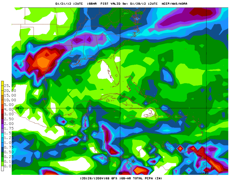
12zGFS is forecasting a total of 5-10 inches of rain ending next Saturday morning for a wide portion South Central Texas. Also I just took a quick look at the 0zECMWF and it calls for 1.5 or more inches for this same areas.......South Texas Storms must be going crazy right now! 
0 likes
The following post is NOT an official forecast and should not be used as such. It is just the opinion of the poster and may or may not be backed by sound meteorological data. It is NOT endorsed by any professional institution including storm2k.org For Official Information please refer to the NHC and NWS products.

Re:
Rgv20 wrote:12zGFS is forecasting a total of 5-10 inches of rain ending next Saturday morning for a wide portion South Central Texas. Also I just took a quick look at the 0zECMWF and it calls for 1.5 or more inches for this same areas.......South Texas Storms must be going crazy right now!
http://i61.photobucket.com/albums/h62/c ... p_ptot.gif
That would be a good thing for Texas, especially for the lakes and rivers.
0 likes
-
Rgv20
- S2K Supporter
- Posts: 2466
- Age: 39
- Joined: Wed Jan 05, 2011 5:42 pm
- Location: Edinburg/McAllen Tx
I know this is not winter related advisory but the Lubbock area is under a High Wind Warning valid for tomorrow.....Its amazing how the Panhandle area gets this crazy winds!
High Wind Warning
URGENT - WEATHER MESSAGE
NATIONAL WEATHER SERVICE LUBBOCK TX
246 PM CST SAT JAN 21 2012
TXZ021>023-027>044-221200-
/O.UPG.KLUB.HW.A.0001.120122T1200Z-120122T2000Z/
/O.NEW.KLUB.HW.W.0001.120122T1200Z-120122T2200Z/
PARMER-CASTRO-SWISHER-BAILEY-LAMB-HALE-FLOYD-MOTLEY-COTTLE-
COCHRAN-HOCKLEY-LUBBOCK-CROSBY-DICKENS-KING-YOAKUM-TERRY-LYNN-
GARZA-KENT-STONEWALL-
INCLUDING THE CITIES OF...FRIONA...BOVINA...DIMMITT...HART...
TULIA...MULESHOE...LITTLEFIELD...OLTON...PLAINVIEW...FLOYDADA...
LOCKNEY...MATADOR...ROARING SPRINGS...PADUCAH...MORTON...
LEVELLAND...LUBBOCK...SLATON...WOLFFORTH...CROSBYTON...RALLS...
DICKENS...SPUR...GUTHRIE...PLAINS...DENVER CITY...BROWNFIELD...
TAHOKA...ODONNELL...POST...JAYTON...ASPERMONT
246 PM CST SAT JAN 21 2012
...HIGH WIND WARNING IN EFFECT FROM 6 AM TO 4 PM CST SUNDAY...
THE NATIONAL WEATHER SERVICE IN LUBBOCK HAS ISSUED A HIGH WIND
WARNING...WHICH IS IN EFFECT FROM 6 AM TO 4 PM CST SUNDAY. THE
HIGH WIND WATCH IS NO LONGER IN EFFECT.
* TIMING...BEGINNING SHORTLY AFTER DAYBREAK ACROSS THE NORTHWEST
SOUTH PLAINS AND EXTREME SOUTHWEST PANHANDLE...AND THEN
SPREADING SOUTHEAST OVER THE REMAINDER OF THE WARNED AREA
THROUGH NOON. WINDS WILL GRADUALLY DIMINISH FROM NORTHWEST TO
SOUTHEAST THROUGHOUT THE AFTERNOON.
* WINDS...WEST TO NORTHWEST FROM 35 TO 45 MPH WITH OCCASIONAL
GUSTS AS HIGH AS 65 MPH.
* IMPACTS...WINDS THIS STRONG CAN CAUSE DAMAGE TO TREES...UTILITY
LINES AND WEAK STRUCTURES. MOTORISTS WITH TRAVEL PLANS INVOLVING
NORTH-TO-SOUTH ORIENTED ROADS WILL BE SUBJECTED TO HAZARDOUS
CROSSWINDS. HIGH PROFILE VEHICLES WILL BE PARTICULARLY
VULNERABLE TO LOSING CONTROL IN WINDS THIS STRONG. THESE WINDS
WILL ALSO CREATE WIDESPREAD BLOWING DUST THAT MAY OCCASIONALLY
REDUCE VISIBILITIES ON THE CAPROCK BELOW ONE MILE.
PRECAUTIONARY/PREPAREDNESS ACTIONS...
A HIGH WIND WARNING MEANS A HAZARDOUS HIGH WIND EVENT IS EXPECTED
OR OCCURRING. SUSTAINED WIND SPEEDS OF AT LEAST 40 MPH OR GUSTS
OF 58 MPH OR MORE CAN LEAD TO PROPERTY DAMAGE.
&&
$$
0 likes
The following post is NOT an official forecast and should not be used as such. It is just the opinion of the poster and may or may not be backed by sound meteorological data. It is NOT endorsed by any professional institution including storm2k.org For Official Information please refer to the NHC and NWS products.
-
Palmer divide shadow
- Tropical Depression

- Posts: 54
- Joined: Thu Dec 29, 2011 11:15 am
- Location: Monument Colorado,but from Sugarland tx
-
weatherdude1108
- Category 5

- Posts: 4228
- Joined: Tue Dec 13, 2011 1:04 pm
- Location: Northwest Austin/Cedar Park, TX
Re: Texas Winter 2011-2012...
Texas Snowman wrote:Portastorm wrote:Wait until South Texas Storms sees the 12z GFS ... which provides several days of heavy rains, off and on, for much of central and south Texas starting next Tuesday. Let's hope it's right and we can make a real dent in this drought!
Yeah, one way or the other, we've got to get our resident "Heat Monger" and his darn bicycle off the road!Frigid temperatures, snow, sleet, freezing rain, or just plain chilly winter-time rain, we've got to break his hold on the winter that wasn't, 2011-12.
Seriously, though, NEVER thought we'd dent/break the drought in Texas during a La Nina winter.
The weather never ceases to surprise...
Could not agree more Texas Snowman!
0 likes
The preceding post is NOT an official forecast, and should not be used as such. It is only the opinion of the poster and may or may not be backed by sound meteorological data. It is NOT endorsed by any professional institution including storm2k.org. For Official Information please refer to the NHC and NWS products.
-
South Texas Storms

- Professional-Met

- Posts: 4255
- Joined: Thu Jun 24, 2010 12:28 am
- Location: Houston, TX
Re: Texas Winter 2011-2012...
I was very happy with the 12z GFS. But now the 0z makes me sad again. SA/Austin back down to .50 inch. Sigh.
0 likes
 We have this
  It is winter, we should have this
  Any long range hopes?
-
aggiecutter
- Category 5
- Posts: 1755
- Joined: Thu Oct 14, 2004 9:22 pm
- Location: Texarkana
Re: Texas Winter 2011-2012...
If your hoping for winter weather, don't read this. I'm going to call this the Dr. Faustus winter. We had our fun the past two winters, and now its time to pay our dues to you know who.
http://www.examiner.com/weather-in-hous ... -20-p-m-ct
http://www.examiner.com/weather-in-hous ... -20-p-m-ct
0 likes
-
srainhoutx

- S2K Supporter
- Posts: 6919
- Age: 68
- Joined: Sun Jan 14, 2007 11:34 am
- Location: Haywood County, NC
- Contact:
Re: Texas Winter 2011-2012...
aggiecutter wrote:If your hoping for winter weather, don't read this. I'm going to call this the Dr. Faustus winter. We had our fun the past two winters, and now its time to pay our dues to you know who.
http://www.examiner.com/weather-in-hous ... -20-p-m-ct
Next week it wil be a different forecast. Flip flopping egos of these energy guys is more comical than Saturday Night Live...
0 likes
Carla/Alicia/Jerry(In The Eye)/Michelle/Charley/Ivan/Dennis/Katrina/Rita/Wilma/Ike/Harvey
Member: National Weather Association
Wx Infinity Forums
http://wxinfinity.com/index.php
Facebook.com/WeatherInfinity
Twitter @WeatherInfinity
Member: National Weather Association
Wx Infinity Forums
http://wxinfinity.com/index.php
Facebook.com/WeatherInfinity
Twitter @WeatherInfinity
-
jasons2k

- Storm2k Executive

- Posts: 8290
- Age: 52
- Joined: Wed Jul 06, 2005 12:32 pm
- Location: The Woodlands, TX
Re: Texas Winter 2011-2012...
Are we ready for some rain?? 
Hopefully it will help fill-up the lakes - we need it (minus the flooding)!!
Hopefully it will help fill-up the lakes - we need it (minus the flooding)!!
0 likes
-
Rgv20
- S2K Supporter
- Posts: 2466
- Age: 39
- Joined: Wed Jan 05, 2011 5:42 pm
- Location: Edinburg/McAllen Tx
SPC's take on the potential for severe weather from 12z 1/24 to 12z 1/25. On Wednesday it looks like East Texas is going to get some heavy rain and looking at the 12zNAM, severe weather should be very isolated..
SPC AC 220825
DAY 3 CONVECTIVE OUTLOOK
NWS STORM PREDICTION CENTER NORMAN OK
0225 AM CST SUN JAN 22 2012
VALID 241200Z - 251200Z
...SYNOPSIS...
AS UPPER TROUGHING CONTINUES TO SWEEP ACROSS ERN CANADA AND THE
ADJACENT NERN CONUS...A TROUGH OVER THE AZ/NM REGION IS FORECAST TO
EVOLVE INTO A CLOSED LOW AND SHIFT SLOWLY EWD INTO W TX AND VICINITY
WITH TIME. IN RESPONSE...A WEAK SURFACE LOW INVOF NM/FAR W TX --
WHILE LIKELY TO REMAIN FAIRLY WEAK -- SHOULD SHIFT SEWD ROUGHLY
ALONG THE RIO GRANDE...REACHING DEEP S TX BY THE END OF THE PERIOD.
THIS LOW AND ASSOCIATED UPPER SYSTEM WILL FOCUS THE MAIN AREA OF
CONVECTIVE POTENTIAL THIS PERIOD.
...TRANSPECOS REGION OF TX SEWD TO THE COAST...
THE APPROACHING UPPER SYSTEM -- AND ASSOCIATED RIO GRANDE VALLEY
AREA CYCLOGENESIS -- WILL EFFECT A WNWLY RETURN OF MOISTURE INTO
COASTAL AND S TX...AND PERHAPS AS FAR NW AS THE TRANSPECOS REGION.
AS COOL AIR ALOFT ASSOCIATED WITH THE UPPER SYSTEM OVERSPREADS W TX
DURING THE AFTERNOON ATOP THE WNWWD STREAM OF MODEST LOW-LEVEL
MOISTURE...A FEW STRONGER AFTERNOON/EVENING CELLS COULD EVOLVE...A
COUPLE PERHAPS BECOMING CAPABLE OF PRODUCING GUSTY WINDS AND HAIL.
MEANWHILE...WITH THE PRIOR FRONT HAVING STALLED INVOF THE GULF
COAST...RICHER BOUNDARY-LAYER MOISTURE WILL BE READILY AVAILABLE
ACROSS THE TX COAST AND INTO S TX. WHILE CAPPED
INITIALLY...CONVECTIVE POTENTIAL SHOULD INCREASE ACROSS PARTS OF
CENTRAL AND S TX WITH TIME -- MAINLY DURING THE EVENING AND
OVERNIGHT AS HEIGHT FALLS ALOFT OVERSPREAD THE AREA AND THE SURFACE
LOW NEARS S TX. WITH LOW-LEVEL SHEAR LIKELY SUFFICIENT FOR AT LEAST
AN ISOLATED/WEAK/BRIEF TORNADO THREAT...AND LOW-END POTENTIAL FOR
HAIL AND WIND WITH A STRONGER STORM OR TWO...WILL INCLUDE A SWATH OF
LOW SEVERE WEATHER PROBABILITY THIS FORECAST -- FROM NEAR MAF EWD
AND SEWD INTO PARTS OF S TX AND THE MIDDLE AND UPPER TX COAST.
..GOSS.. 01/22/2012
Look at those Rainfall Totals for east Texas ending 12z Friday Jan 27!
0 likes
The following post is NOT an official forecast and should not be used as such. It is just the opinion of the poster and may or may not be backed by sound meteorological data. It is NOT endorsed by any professional institution including storm2k.org For Official Information please refer to the NHC and NWS products.
-
somethingfunny

- ChatStaff

- Posts: 3926
- Age: 37
- Joined: Thu May 31, 2007 10:30 pm
- Location: McKinney, Texas
Re: Texas Winter 2011-2012...
This isn't exactly "winter weather", but I know that alot of people like to just check this thread for updates. There's a dust storm coming:

0 likes
I am not a meteorologist, and any posts made by me are not official forecasts or to be interpreted as being intelligent. These posts are just my opinions and are probably silly opinions.
-
Portastorm

- Storm2k Moderator

- Posts: 9954
- Age: 63
- Joined: Fri Jul 11, 2003 9:16 am
- Location: Round Rock, TX
- Contact:
Re: Texas Winter 2011-2012...
Big Texas weather story of the day, to be sure. For those of you on Facebook, "Texas Storm Chasers" has some great photos up from Lubbock and Amarillo. Looks like the 1930s Dust Bowl.
0 likes
Any forecasts under my name are to be taken with a grain of salt. Get your best forecasts from the National Weather Service and National Hurricane Center.
-
Rgv20
- S2K Supporter
- Posts: 2466
- Age: 39
- Joined: Wed Jan 05, 2011 5:42 pm
- Location: Edinburg/McAllen Tx
Not exactly Winter Weather.....but is Severe Storms in January consider part of winter?
NWS in Brownsville early morning discussion
LONG TERM /TUESDAY NIGHT THROUGH SUNDAY/...MODELS APPEAR TO
FINALLY COME TO A DECENT AGREEMENT WITH THE 500MB LOW/TROUGH
ACROSS SOUTHERN NEW MEXICO/NORTHERN MEXICO TUESDAY SWINGING
EASTWARD INTO WEST AND SOUTHWEST TEXAS WEDNESDAY. SURFACE LOW
PRESSURE WILL DEVELOP ALONG THE SOUTH TX COAST AND NORTHEAST
MEXICO COAST IN RESPONSE TO THE UPPER LEVEL LOW/TROUGH APPROACHING
FROM THE WEST. MAIN CONCERN IS THE POTENTIAL FOR SEVERE WEATHER AS
LAPSE RATES WILL STEEPEN ALOFT WITH DIFLUENCE INCREASING ACROSS
CENTRAL TX TUESDAY INTO TUES NIGHT WITH A LARGE AREA OF CONVECTION
DEVELOPING ACROSS EAST TX EXTENDING SOUTHWARD TOWARDS THE RIO
GRANDE PLAINS. NOT SURE IF THE CAP WILL HOLD ACROSS THE AREA TO
KEEP THUNDERSTORMS FROM BACK BUILDING INTO THE CWA TUES NIGHT BUT
WILL GO AHEAD AND INCREASE POPS TO REFLECT HIGHER RAIN CHANCES
NORTH AND EAST. TOO EARLY TO MENTION SEVERE WORDING IN FORECAST
BUT THE THREAT OF DAMAGING WINDS AND HAIL IS POSSIBLE IF A BROKEN
LINE OF MULTI-CELLULAR CONVECTION DEVELOPS AND MOVES THROUGH
PORTIONS OF THE RIO GRANDE PLAINS TUES NIGHT INTO EARLY WEDNESDAY.
0 likes
The following post is NOT an official forecast and should not be used as such. It is just the opinion of the poster and may or may not be backed by sound meteorological data. It is NOT endorsed by any professional institution including storm2k.org For Official Information please refer to the NHC and NWS products.
-
Portastorm
- Storm2k Moderator
- Posts: 9954
- Age: 63
- Joined: Fri Jul 11, 2003 9:16 am
- Location: Round Rock, TX
- Contact:
Re: Texas Winter 2011-2012...
Yep, much of central, south, and southeast Texas is facing a very real midwinter threat of heavy rain and thunderstorms and maybe even a tornado or two ... starting tomorrow through Wednesday. Of course we'll welcome the rain but everyone should keep an eye on the "severe" aspect of things.
0 likes
Any forecasts under my name are to be taken with a grain of salt. Get your best forecasts from the National Weather Service and National Hurricane Center.


Re: Texas Winter 2011-2012...
With respect to longer range, the models are all over the place with respect to the teleconnection indices. I tend to side with the European, which at 0z has a slightly negative NAO, slightly negative AO, and negative EPO at days 8-10. What we need is a +PNA to get things going, but I see nothing to suggest that will come to fruition, yet. Perhaps Srain can offer some words of wisdom and HOPE. 
0 likes
-
TeamPlayersBlue

- Category 5
- Posts: 3524
- Joined: Tue Feb 02, 2010 1:44 am
- Location: Denver/Applewood, CO
Very excited to see the 'washout' coming. Our lakes, trees, rivers etc need it. I hope the drainage systems can hold up! I might do a check of some of the drainage areas in my neighborhood to make sure leaves arent blocking them etc. Could help.
0 likes
Personal Forecast Disclaimer:
The posts in this forum are NOT official forecast and should not be used as such. They are just the opinion of the poster and may or may not be backed by sound meteorological data. They are NOT endorsed by any professional institution or storm2k.org. For official information, please refer to the NHC and NWS products.
The posts in this forum are NOT official forecast and should not be used as such. They are just the opinion of the poster and may or may not be backed by sound meteorological data. They are NOT endorsed by any professional institution or storm2k.org. For official information, please refer to the NHC and NWS products.
-
gboudx

- S2K Supporter
- Posts: 4090
- Joined: Thu Sep 04, 2003 1:39 pm
- Location: Rockwall, Tx but from Harvey, La
Re:
TeamPlayersBlue wrote:Very excited to see the 'washout' coming. Our lakes, trees, rivers etc need it. I hope the drainage systems can hold up! I might do a check of some of the drainage areas in my neighborhood to make sure leaves arent blocking them etc. Could help.
I'm hoping the soil moisture content is back to, or near normal this time around. The past 2 soaking rains the DFW area has gotten generated very little run-off due to the ground acting like a sponge. The lake levels didn't really respond. We need lots of run-off this time to start moving these reservoir levels upward.
0 likes
-
TeamPlayersBlue
- Category 5
- Posts: 3524
- Joined: Tue Feb 02, 2010 1:44 am
- Location: Denver/Applewood, CO
The lake i live next to improved greatly from the 6.5" we received in the last washout. The last large rain event down here wasnt as widespread though, most areas had a couple of inches. Before the rain, i could see the bottom of the lake in some areas, now the bottom of the lake is no longer visible anywhere but of course it is still very low. This rain event looks to be much more widespread for the whole central to eastern texas area. Ill be happy with more than 2.5"
0 likes
Personal Forecast Disclaimer:
The posts in this forum are NOT official forecast and should not be used as such. They are just the opinion of the poster and may or may not be backed by sound meteorological data. They are NOT endorsed by any professional institution or storm2k.org. For official information, please refer to the NHC and NWS products.
The posts in this forum are NOT official forecast and should not be used as such. They are just the opinion of the poster and may or may not be backed by sound meteorological data. They are NOT endorsed by any professional institution or storm2k.org. For official information, please refer to the NHC and NWS products.
-
Portastorm
- Storm2k Moderator
- Posts: 9954
- Age: 63
- Joined: Fri Jul 11, 2003 9:16 am
- Location: Round Rock, TX
- Contact:
Re: Texas Winter 2011-2012...
Lively period coming up for south central Texas. The afternoon AFD out of EWX is actually quite a good discussion and highlights some interesting comparisons to the Jan. 9th event and what is expected in the next 48 hours. Here is a snippet:
AREA FORECAST DISCUSSION
NATIONAL WEATHER SERVICE AUSTIN/SAN ANTONIO TX
320 PM CST MON JAN 23 2012
.DISCUSSION...
ANOTHER CUT-OFF LOW TO PROMOTE EXCELLENT RAIN CHANCES ACROSS MUCH
OF SOUTH CENTRAL TEXAS TUESDAY NIGHT THROUGH WEDNESDAY. SIMILAR TO
THE UPPER LOW PATTERN WHICH OCCURRED ON MONDAY...JAN 9...THIS
UPPER LOW HAS A SURROUNDING ENVIRONMENT OF STABLE AND DRY PACIFIC
AIR EXPECTED TO WRAP AROUND IT AS IT MOVES INTO SOUTH CENTRAL
TEXAS. HOWEVER...COMPARISON OF THE FORECAST UPPER LOW FOR EARLY
WEDNESDAY VERSUS THE ONE THAT MOVED THROUGH ON JAN 9 SHOWS A
SIMILAR SIZE BUT MORE N-S ORIENTATION FOR THE UPCOMING LOW INSTEAD
OF A MORE CIRCULAR AND SLIGHTLY E-W ORIENTATION OF THE JAN 9 LOW.
THUS AM EXPECTING AN INCREASED POTENTIAL FOR A NEAR SOLID COMPLEX OF
RAIN TO DEVELOP EARLY WEDNESDAY MORNING OVER THE WESTERN COUNTIES
AND DRAGGING EASTWARD ACROSS THE EASTERN TWO THIRDS OF THE AREA.
THIS SHOULD HOPEFULLY YEILD A BIT MORE RAIN OVER THE CENTRAL
COUNTIES AS COMPARED TO THE EVENT FROM JAN 9.
ANOTHER DIFFERENCE IS THAT THIS N-S ORIENTED FOCUS FOR RAIN
SHOULD RESULT IN STRONGER CONVERGENCE ALONG THE N-S AXIS TO
PROMOTE STRONGER STORMS AND POSSIBLY SOME WIND DAMAGE OR EVEN A
WEAK TORNADO. HIGHEST HELICITIES SHOLD BE EXPECTED TO OCCUR S/SE
OF SAT SOME SOME MODEL DATA SHOWING VALUES OF 300 M2/S2. THE
THREAT FOR HIGH WINDS SHOULD BE LESS OVER WESTERN COUNTIES...BUT
EVENING TIMING OF CONVECTION AND COLDER AIR ADVECTION ALOFT FROM
THE UPPER LOW COULD SUPPORT A FEW HAIL STORMS. OVERALL THE
OVERNIGHT/DAYBREAK TIMING OF A WINTER EVENT SHOULD MEAN A MARGINAL
SEVERE THREAT ACROSS NEARLY ALL OF SOUTH CENTRAL TX. IN ADDITION
TO THE SEVERE POTENTIAL...CUMULATIVE RAINS ALONG AND EAST OF
HIGHWAY 281 COULD APPROACH 2 INCHES...WITH HIGHER AMOUNTS OVER 3
INCHES POSSIBLE IN THE COUNTIES EAST OF A AUSTIN TO CUERO LINE.
WITH THE HIGHEST CONVECTIVE POTENTIAL EXPECTED TO REACH THE I-35
CORRIDOR AROUND DAYBREAK WEDNESDAY...POPS ARE EXPECTED TO TAPER
QUICKLY FROM WEST TO EAST DURING THE DAY WEDNESDAY...WITH COOLER
AND MORE STABLE AIR LOWERING RAIN POTENTIAL OVER THE AREA DESPITE
THE UPPER LOW BEING OVERHEAD. THE WEATHER IN THIS PERIOD FROM LATE
IN THE DAY WEDNESDAY THROUGH THURSDAY SHOULD BE SIMILAR TO THAT OF
JAN 9-10 WITH COLD AND MOIST AIR MOVING SOUTH WHILE CLOUDS REMAIN
ABUNDANT. MODELS SHOW SOME WRAP-AROUND RAINS TO POSSIBLY AFFECT
OUR NORTHERN COUNTIES THROUGH THURSDAY...BUT WILL DOWNPLAY THIS
EFFECT AND FAVOR THE DRIER NAM OVER THE WETTER GFS.
0 likes
Any forecasts under my name are to be taken with a grain of salt. Get your best forecasts from the National Weather Service and National Hurricane Center.
Who is online
Users browsing this forum: SnowyOwl31, Stratton23, wxman22 and 219 guests