ENSO Updates (2007 thru 2023)

This is the general tropical discussion area. Anyone can take their shot at predicting a storms path.

Moderator: S2k Moderators

Forum rules

The posts in this forum are NOT official forecasts and should not be used as such. They are just the opinion of the poster and may or may not be backed by sound meteorological data. They are NOT endorsed by any professional institution or STORM2K. For official information, please refer to products from the National Hurricane Center and National Weather Service.

Help Support Storm2K
Message
Author
User avatar
cycloneye
Admin
Admin
Posts: 145294
Age: 68
Joined: Thu Oct 10, 2002 10:54 am
Location: San Juan, Puerto Rico

Re: ENSO Updates

#1821 Postby cycloneye » Wed Jan 04, 2012 10:33 am

Australian's 1/4/12 update

La Nina is still holding firm according to their update.

La Niña persists over Pacific
Issued on Wednesday 4 January | Product Code IDCKGEWWOO

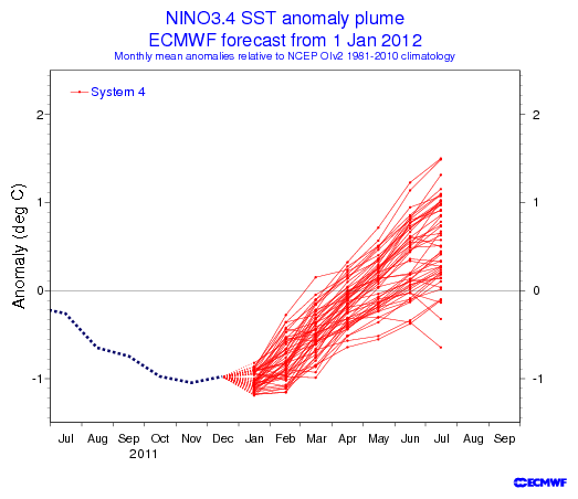
La Niña conditions continue over the tropical Pacific Ocean. The majority of climate models surveyed by the Bureau suggest this La Niña may be close to its peak, with a gradual decline expected over the remainder of the austral summer and early autumn.

Climate indicators of ENSO continue to exceed La Niña thresholds. Despite some cooling (i.e. strengthening of the La Niña pattern) at the surface of the tropical Pacific over the past fortnight, sea surface temperatures remain less extreme (i.e., warmer) than at the same time in 2010-11. Atmospheric indicators of La Niña also strengthened slightly over the last fortnight, with the Southern Oscillation Index (SOI) monthly December value of +23 being the highest value since the breakdown of the 2010-11 event in autumn 2011.


http://www.bom.gov.au/climate/enso/

The subsurface waters in the Pacific continue to be cold. The warmer waters remain in the Western Pacific.

Image
0 likes   
Visit the Caribbean-Central America Weather Thread where you can find at first post web cams,radars
and observations from Caribbean basin members Click Here

User avatar
cycloneye
Admin
Admin
Posts: 145294
Age: 68
Joined: Thu Oct 10, 2002 10:54 am
Location: San Juan, Puerto Rico

Re: ENSO Updates

#1822 Postby cycloneye » Thu Jan 05, 2012 1:38 pm

Climate Prediction Center January Update

Weak to Moderate La Nina thru early Spring and then dissipates between March and May are the headlines of this January update.

http://www.cpc.ncep.noaa.gov/products/a ... odisc.html

Synopsis: La Niña is expected to continue into the Northern spring 2012.

During December 2011, below-average sea surface temperatures (SST) associated with La Niña continued across the eastern and central equatorial Pacific Ocean (Fig. 1). The weekly SST index in the Niño-3.4 region remained near -1.0oC throughout the month (Fig. 2), indicating a weak to moderate La Niña. The oceanic heat content (average temperature in the upper 300m of the ocean) anomalies strengthened across the eastern Pacific (Fig. 3), reflecting a large area of below-average temperatures in the subsurface (Fig. 4). In the atmosphere, anomalous low-level easterly and upper-level westerly winds strengthened over the central and west-central Pacific. Convection remained suppressed in the western and central Pacific and enhanced over northern Australia and parts of Indonesia and the Philippine Islands (Fig. 5). Consistent with these conditions, the Southern Oscillation Index (SOI) also strengthened. This evolution is consistent with past events, in which the atmospheric components of La Niña become strongest and most well-defined during the Northern Hemisphere winter. Collectively, the ongoing oceanic and atmospheric patterns reflect the continuation of a weak to moderate La Niña.

A majority of models predict a weak or moderate strength La Niña to peak during the December – February season, and then to continue into early Northern Hemisphere spring season before dissipating during the March to May period (Fig. 6). A slight majority of models predict La Niña to remain weak (3-month average SST anomaly in the Niño-3.4 region between -0.5 and -0.9oC) this winter, while several others predict a moderate-strength episode (anomaly in the Niño-3.4 region between -1.0 and -1.4oC). The latest observations, combined with model forecasts, suggest that La Niña will be of weak-to-moderate strength this winter, and will continue thereafter as a weak event until it likely dissipates sometime between March and May.

0 likes   
Visit the Caribbean-Central America Weather Thread where you can find at first post web cams,radars
and observations from Caribbean basin members Click Here

WeatherGuesser
Category 5
Category 5
Posts: 2672
Joined: Tue Jun 29, 2010 6:46 am

#1823 Postby WeatherGuesser » Thu Jan 05, 2012 7:56 pm

So does that mean warm Spring, hot Summer? Cool Spring/Summer? Wet? Dry?

And I'm not the least bit interested in what "JB Sez" so please don't quote him in reply to this question.
0 likes   

User avatar
cycloneye
Admin
Admin
Posts: 145294
Age: 68
Joined: Thu Oct 10, 2002 10:54 am
Location: San Juan, Puerto Rico

Re:

#1824 Postby cycloneye » Thu Jan 05, 2012 8:36 pm

WeatherGuesser wrote:So does that mean warm Spring, hot Summer? Cool Spring/Summer? Wet? Dry?

And I'm not the least bit interested in what "JB Sez" so please don't quote him in reply to this question.


Since this thread is at Talking Tropics forum,it means the 2012 Atlantic hurricane season may be active or not depending if it's Neutral ENSO or El Nino develops by the Summer or fall.
0 likes   
Visit the Caribbean-Central America Weather Thread where you can find at first post web cams,radars
and observations from Caribbean basin members Click Here

User avatar
cycloneye
Admin
Admin
Posts: 145294
Age: 68
Joined: Thu Oct 10, 2002 10:54 am
Location: San Juan, Puerto Rico

Re: ENSO=CPC January update=La Nina likely dissipates by May

#1825 Postby cycloneye » Sat Jan 07, 2012 6:36 am

The daily SOI index has been going down in the past few days and that signals La Nina is weakening.

7 Jan 2012 1010.53 1009.35 -16.15

http://www.longpaddock.qld.gov.au/seaso ... soivalues/
0 likes   
Visit the Caribbean-Central America Weather Thread where you can find at first post web cams,radars
and observations from Caribbean basin members Click Here

User avatar
cycloneye
Admin
Admin
Posts: 145294
Age: 68
Joined: Thu Oct 10, 2002 10:54 am
Location: San Juan, Puerto Rico

Re: ENSO Updates

#1826 Postby cycloneye » Mon Jan 09, 2012 9:51 am

Climate Prediction Center 1/9/12 weekly update

No changes from last week's data at Nino 3.4 area. The daily SOI index stopped the downward trend at least for now.

http://www.longpaddock.qld.gov.au/seaso ... soivalues/


Last Week's update

Niño 4= -1.1ºC
Niño 3.4= -1.0ºC
Niño 3= -0.9ºC
Niño 1+2= -0.9ºC

This Week's update

Niño 4= -1.0ºC
Niño 3.4= -1.0ºC
Niño 3= -0.8ºC
Niño 1+2= -1.1ºC


http://www.longpaddock.qld.gov.au/seaso ... soivalues/
0 likes   
Visit the Caribbean-Central America Weather Thread where you can find at first post web cams,radars
and observations from Caribbean basin members Click Here

User avatar
Ntxw
Storm2k Moderator
Storm2k Moderator
Posts: 22784
Joined: Wed Oct 21, 2009 6:34 pm
Location: DFW, Texas

#1827 Postby Ntxw » Wed Jan 11, 2012 4:49 pm

Daily SOI's have been steady well below Nina levels for a substantial period now. I bet by month's end we'll see a dramatic rise in SST's (relative to what they are now) and La Nina on the brink of collapse, just my guess :lol:
Last edited by Ntxw on Tue Jan 24, 2012 3:11 pm, edited 2 times in total.
0 likes   
The above post and any post by Ntxw is NOT an official forecast and should not be used as such. It is just the opinion of the poster and may or may not be backed by sound meteorological data. It is NOT endorsed by any professional institution including Storm2k. For official information, please refer to NWS products.

  Help support Storm2K!
Help Support Storm2K

User avatar
cycloneye
Admin
Admin
Posts: 145294
Age: 68
Joined: Thu Oct 10, 2002 10:54 am
Location: San Juan, Puerto Rico

Re: ENSO Updates

#1828 Postby cycloneye » Thu Jan 12, 2012 3:44 pm

La Nina is still hanging on quite good if you see how the subsurface waters are doing. The big question is when La Nina goes away during the late Spring timeframe,how fast it goes and when Neutral conditions take control,if it stays or goes away to let El Nino arrive during the Summer and Fall months.

Image

Image
0 likes   
Visit the Caribbean-Central America Weather Thread where you can find at first post web cams,radars
and observations from Caribbean basin members Click Here

User avatar
cycloneye
Admin
Admin
Posts: 145294
Age: 68
Joined: Thu Oct 10, 2002 10:54 am
Location: San Juan, Puerto Rico

Re: ENSO Updates

#1829 Postby cycloneye » Fri Jan 13, 2012 7:38 pm

The Aussies Enso model (POAMA) forecasts in the January update neutral conditions going thru the June,July and August timeframe. Let's see if the next batch of forecasts by this and other models stay with this scenario or there are changes.

http://www.bom.gov.au/climate/poama2.4/poama.shtml

Image
0 likes   
Visit the Caribbean-Central America Weather Thread where you can find at first post web cams,radars
and observations from Caribbean basin members Click Here

User avatar
Rgv20
S2K Supporter
S2K Supporter
Posts: 2466
Age: 38
Joined: Wed Jan 05, 2011 5:42 pm
Location: Edinburg/McAllen Tx

#1830 Postby Rgv20 » Sun Jan 15, 2012 3:41 pm

Euro calling for El Nino as we head until the heart of Atlantic Tropical Activity.....My gut tells me it may be a bit overzealous on El Nino returning by the Summer.

Image
0 likes   
The following post is NOT an official forecast and should not be used as such. It is just the opinion of the poster and may or may not be backed by sound meteorological data. It is NOT endorsed by any professional institution including storm2k.org For Official Information please refer to the NHC and NWS products.

User avatar
cycloneye
Admin
Admin
Posts: 145294
Age: 68
Joined: Thu Oct 10, 2002 10:54 am
Location: San Juan, Puerto Rico

Re: ENSO Updates

#1831 Postby cycloneye » Sun Jan 15, 2012 5:05 pm

Rgv20,Euro is sandwitched between two models that call for Cool Neutral above and below your post :) Here is the CFS (NCEP) model.

Image

However,the new version of the CFS model is a tad warmer going to Warm Neutral around the Peak of the season.

Image
0 likes   
Visit the Caribbean-Central America Weather Thread where you can find at first post web cams,radars
and observations from Caribbean basin members Click Here

dexterlabio
Category 5
Category 5
Posts: 3468
Joined: Sat Oct 24, 2009 11:50 pm

Re: ENSO Updates

#1832 Postby dexterlabio » Tue Jan 17, 2012 6:46 am

Based on the trend shown in the ENSO forecast, I think a weak episode of El Nino is possible to start in November or December. Though I believe that the remaining months of the year after this ongoing La Nina will be neutral. :)
0 likes   
Personal Forecast Disclaimer:
The posts in this forum are NOT official forecast and should not be used as such. They are just the opinion of the poster and may or may not be backed by sound meteorological data. They are NOT endorsed by any professional institution or storm2k.org. For official information, please refer to the NHC and NWS products.

User avatar
cycloneye
Admin
Admin
Posts: 145294
Age: 68
Joined: Thu Oct 10, 2002 10:54 am
Location: San Juan, Puerto Rico

Re: ENSO Updates

#1833 Postby cycloneye » Thu Jan 19, 2012 4:00 pm

The January update of the ENSO models shows Neutral conditions during the August,September and October period,but it also shows El Nino creeping up slowly. It will be a close call IMO about having at least a weak El Nino during the peak of the Atlantic hurricane season. Let's wait and see how the next two to three months of updates come out.

Code: Select all

Season La Niña Neutral El Niño
JFM 2012 97% 3% 0.1%
FMA 2012 79% 21% 0.2%
MAM 2012 52% 48% 0.4%
AMJ 2012 35% 61% 4%
MJJ 2012 29% 56% 15%
JJA 2012 25% 55% 20%
JAS 2012 22% 55% 23%
ASO 2012 22% 54% 24%
SON 2012 21% 54% 25%

- Made in Jan 2012


Image

Image

http://portal.iri.columbia.edu/portal/s ... 2&userID=2
0 likes   
Visit the Caribbean-Central America Weather Thread where you can find at first post web cams,radars
and observations from Caribbean basin members Click Here

User avatar
cycloneye
Admin
Admin
Posts: 145294
Age: 68
Joined: Thu Oct 10, 2002 10:54 am
Location: San Juan, Puerto Rico

Re: ENSO Updates

#1834 Postby cycloneye » Sat Jan 21, 2012 12:19 pm

Since the 13th of January,the daily SOI index has gone positive,a sign that La Nina is still hanging on and not going away anytime soon.

http://www.longpaddock.qld.gov.au/seaso ... soivalues/
0 likes   
Visit the Caribbean-Central America Weather Thread where you can find at first post web cams,radars
and observations from Caribbean basin members Click Here

User avatar
gigabite
S2K Supporter
S2K Supporter
Posts: 916
Age: 72
Joined: Wed May 05, 2004 4:09 pm
Location: Naples, Florida

Re: ENSO Updates

#1835 Postby gigabite » Sun Jan 22, 2012 2:33 am

Image
The la Nina is hanging on, but I don’t think it will be for much longer. There is a positive correlation between the 1983-1997 string of NINO 3.4 anomaly (the blue line), and the 1997-2011 string (the red line). There may be a bit of a phase shift. I don’t think it is more than 2 months. A basic graphical trend (the green line) indicates an up tick. The correlation coefficient is 0.55 between like data. I think that would better than a coin flip that in the next couple of months there will be a sharp up tick in the sea surface temperature in the Pacific.
Image

Then there is the distance to the sun and the size of the sun, two major weather factors.
1. The Earth is close to the Sun, especially compared to last year.
2. The Sun is approaching its maximum

Off topic: Looking at this graph I think that whoever figures that the start of the 14th b'ak'tun, 13.0.0.0.0, was on December 21, 2012 (the winter solstice) missed it by 2 years.


Uploaded with ImageShack.us
Last edited by gigabite on Sun Jan 22, 2012 9:01 pm, edited 1 time in total.
0 likes   

WeatherWiseGuy
Tropical Depression
Tropical Depression
Posts: 92
Joined: Sat Jul 23, 2005 7:48 pm
Location: Florida

Re: ENSO Updates

#1836 Postby WeatherWiseGuy » Sun Jan 22, 2012 8:24 am

We've had two years in a row of La Nina conditions. My gut instinct tells me that we would surely have at least one neutral year rather than going directly into an El Nino episode. I also did a little research and found this quote from http://www.elnino.noaa.gov/lanina_new_faq.html:

"Over the long-term record, sea-surface temperatures in the central and eastern tropical Pacific diverge from normal in a roughly bell-curve fashion, with El Niño and La Niña at the tails of the curve. Some researchers argue there are only two states, El Niño and non-El Niño, while others believe either El Niño or La Niña is always present to a greater or lesser degree. According to one expert, NCAR's Kevin Trenberth, El Niños were present 31% of the time and La Niñas 23% of the time from 1950 to 1997, leaving about 46% of the period in a neutral state. The frequency of El Niños has increased in recent decades, a shift being studied for its possible relationship to global climate change."

So, I feel like this kind of confirms my thinking, but I could be completely wrong (that wouldn't be a surprise :lol:)
0 likes   

User avatar
cycloneye
Admin
Admin
Posts: 145294
Age: 68
Joined: Thu Oct 10, 2002 10:54 am
Location: San Juan, Puerto Rico

Re: ENSO Updates

#1837 Postby cycloneye » Mon Jan 23, 2012 1:13 pm

Climate Prediction Center 1/23/12 Weekly update

Nino 3.4 goes down to -1.1C and that is a little bit more colder than last week's -0.9C.

http://www.cpc.ncep.noaa.gov/products/a ... ts-web.pdf
0 likes   
Visit the Caribbean-Central America Weather Thread where you can find at first post web cams,radars
and observations from Caribbean basin members Click Here

User avatar
Kingarabian
S2K Supporter
S2K Supporter
Posts: 15980
Joined: Sat Aug 08, 2009 3:06 am
Location: Honolulu, Hawaii

#1838 Postby Kingarabian » Mon Jan 23, 2012 3:27 pm

Could be fools gold. I remember el nino held on pretty well in 09-10 going into early spring but it then faded pretty fast and quickly transitioned into la nina.
0 likes   
RIP Kobe Bryant

User avatar
Ntxw
Storm2k Moderator
Storm2k Moderator
Posts: 22784
Joined: Wed Oct 21, 2009 6:34 pm
Location: DFW, Texas

Re:

#1839 Postby Ntxw » Tue Jan 24, 2012 3:11 pm

Ntxw wrote:Daily SOI's have been steady well below Nina levels for a substantial period now. I bet by month's end we'll see a dramatic rise in SST's (relative to what they are now) and La Nina on the brink of collapse, just my guess :lol:


Well boy was I wrong, not a shocker lately :oops:. Sea surface temperatures are rising though near the region but one can't really tell if it's really enso change or just seasonal changes for the south Pacific until summer.
0 likes   
The above post and any post by Ntxw is NOT an official forecast and should not be used as such. It is just the opinion of the poster and may or may not be backed by sound meteorological data. It is NOT endorsed by any professional institution including Storm2k. For official information, please refer to NWS products.


  Help support Storm2K!

Help Support Storm2K


User avatar
cycloneye
Admin
Admin
Posts: 145294
Age: 68
Joined: Thu Oct 10, 2002 10:54 am
Location: San Juan, Puerto Rico

Re: ENSO=CPC 1/23/12 update=Nino 3.4 down to -1.1C

#1840 Postby cycloneye » Tue Jan 24, 2012 3:31 pm

The Weak to Moderate La Nina doesn't want to go away for now as the data shows.

Image
0 likes   
Visit the Caribbean-Central America Weather Thread where you can find at first post web cams,radars
and observations from Caribbean basin members Click Here


Return to “Talkin' Tropics”

Who is online

Users browsing this forum: Google Adsense [Bot], Hurricaneman and 43 guests