Texas Winter 2011-2012...

Winter Weather Discussion

Moderator: S2k Moderators

Forum rules

The posts in this forum are NOT official forecast and should not be used as such. They are just the opinion of the poster and may or may not be backed by sound meteorological data. They are NOT endorsed by any professional institution or STORM2K.

Help Support Storm2K
Message
Author
User avatar
Tireman4
S2K Supporter
S2K Supporter
Posts: 5853
Age: 59
Joined: Fri Jun 30, 2006 1:08 pm
Location: Humble, Texas
Contact:

Re: Re:

#2541 Postby Tireman4 » Thu Feb 02, 2012 6:04 pm

Ntxw wrote:
Portastorm wrote:That is NOT what the Portastorm Weather Center is forecasting for the next six weeks. Colder is coming to a Texas city near you!


That's a pretty bold forecast coming out of the PWC! Given that when things could go wrong this winter, it does. I'm shocked the center has gone all out :P. Ridge could set up too far east this time. Though I will never give in to the warm mongerer ideals!

Rumor has been going around that a secret shipment from the Moscow Vodka Museum (frigid atm anyone?) has quickly made it's way into the Portacenter secret vault...shhh


Everybody must get likkered up ( to the tune of Everybody Must Get Stoned)!!!!!
0 likes   

Palmer divide shadow
Tropical Depression
Tropical Depression
Posts: 54
Joined: Thu Dec 29, 2011 11:15 am
Location: Monument Colorado,but from Sugarland tx

#2542 Postby Palmer divide shadow » Thu Feb 02, 2012 6:33 pm

Another personal foul on wxman!!.Well excuse me,off to the denver forun to discuss a blizzard.
0 likes   

User avatar
TeamPlayersBlue
Category 5
Category 5
Posts: 3445
Joined: Tue Feb 02, 2010 1:44 am
Location: Denver/Applewood, CO

#2543 Postby TeamPlayersBlue » Thu Feb 02, 2012 7:56 pm

http://policlimate.com/weather/

You guys been to this site yet? Been on for the last hour. Good stuff. Joe Bastardi blows this guy up on twitter.
0 likes   
Personal Forecast Disclaimer:
The posts in this forum are NOT official forecast and should not be used as such. They are just the opinion of the poster and may or may not be backed by sound meteorological data. They are NOT endorsed by any professional institution or storm2k.org. For official information, please refer to the NHC and NWS products.

User avatar
Portastorm
Storm2k Moderator
Storm2k Moderator
Posts: 9914
Age: 63
Joined: Fri Jul 11, 2003 9:16 am
Location: Round Rock, TX
Contact:

Re:

#2544 Postby Portastorm » Thu Feb 02, 2012 9:15 pm

TeamPlayersBlue wrote:http://policlimate.com/weather/

You guys been to this site yet? Been on for the last hour. Good stuff. Joe Bastardi blows this guy up on twitter.


I've seen JB tweet like crazy about this guy. Never checked out his site until you posted that link. You're not kidding ... there is a lot of good stuff on there! Thanks for the tip, TeamPlayersBlue.
0 likes   
Any forecasts under my name are to be taken with a grain of salt. Get your best forecasts from the National Weather Service and National Hurricane Center.

User avatar
Rgv20
S2K Supporter
S2K Supporter
Posts: 2466
Age: 38
Joined: Wed Jan 05, 2011 5:42 pm
Location: Edinburg/McAllen Tx

#2545 Postby Rgv20 » Fri Feb 03, 2012 12:04 am

:uarrow: I emailed him a couple of weeks ago and he said I could use the graphics on his site provided we put his link to the website..

Hey Porta have you looked at the 0zNAM,0zGFS and 12zECMWF....Sunday is looking like a Cold drizzly day with highs in the upper 40s for Austin. Not Icy weather but at least is something huh :lol:


Meanwhile in my part of the State it looks like some welcome rains are in store starting Saturday :P

Image
A series of upper level disturbances will lift warm humid air overtop chilly air near the ground, producing periods of rain late Saturday and Sunday, which could linger into Monday and beyond. Current forecasts suggest between 1 and 2 inches Valley-wide through Tuesday. Additional rain is possible later next week, with plenty of clouds and sprinkles/drizzle in between. Bottom line: Welcome rain will be a drought "time-out" but nothing more. If you've enjoyed the warm/humid weather recently, don't get used to it; after Saturday, chillier weather settles in for awhile.
Last edited by Rgv20 on Fri Feb 03, 2012 12:21 am, edited 1 time in total.
0 likes   
The following post is NOT an official forecast and should not be used as such. It is just the opinion of the poster and may or may not be backed by sound meteorological data. It is NOT endorsed by any professional institution including storm2k.org For Official Information please refer to the NHC and NWS products.

User avatar
Rgv20
S2K Supporter
S2K Supporter
Posts: 2466
Age: 38
Joined: Wed Jan 05, 2011 5:42 pm
Location: Edinburg/McAllen Tx

#2546 Postby Rgv20 » Fri Feb 03, 2012 12:14 am

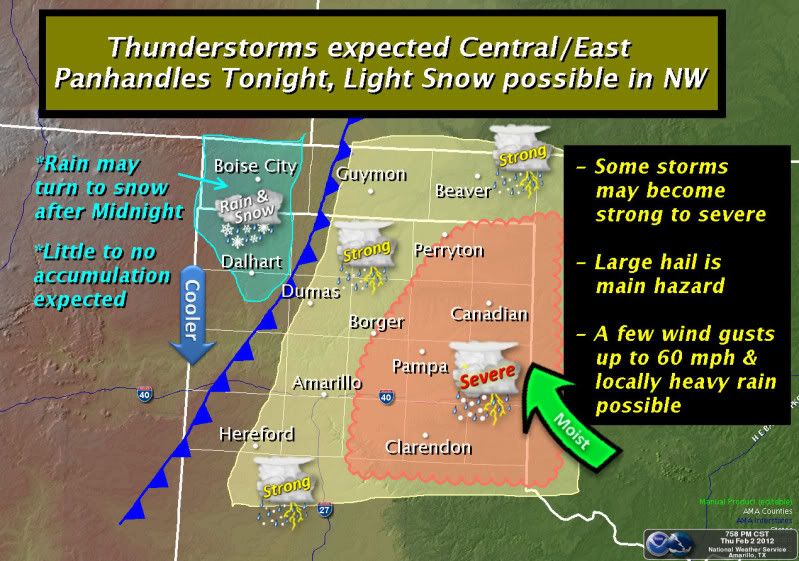
The Texas Panhandle sure sees some crazy weather....Most of the Panhandle is under a Severe Thunderstorm Watch.

Image
0 likes   
The following post is NOT an official forecast and should not be used as such. It is just the opinion of the poster and may or may not be backed by sound meteorological data. It is NOT endorsed by any professional institution including storm2k.org For Official Information please refer to the NHC and NWS products.

User avatar
Portastorm
Storm2k Moderator
Storm2k Moderator
Posts: 9914
Age: 63
Joined: Fri Jul 11, 2003 9:16 am
Location: Round Rock, TX
Contact:

Re: Texas Winter 2011-2012...

#2547 Postby Portastorm » Fri Feb 03, 2012 9:48 am

Rgv, I don't know about 40s Sunday here ... but it is possible based on those model runs you referenced. Current NWS forecast says low 50s. Regardless, I'm liking how our QPF values have risen up to about 1.25 inches for this coming event. Every little bit helps!
0 likes   
Any forecasts under my name are to be taken with a grain of salt. Get your best forecasts from the National Weather Service and National Hurricane Center.

User avatar
Portastorm
Storm2k Moderator
Storm2k Moderator
Posts: 9914
Age: 63
Joined: Fri Jul 11, 2003 9:16 am
Location: Round Rock, TX
Contact:

Re: Texas Winter 2011-2012...

#2548 Postby Portastorm » Fri Feb 03, 2012 1:57 pm

In the words of famed ABC sportscaster Keith Jackson: "Whoa, nellie!"


Image

Uploaded with ImageShack.us
0 likes   
Any forecasts under my name are to be taken with a grain of salt. Get your best forecasts from the National Weather Service and National Hurricane Center.

User avatar
wxman57
Moderator-Pro Met
Moderator-Pro Met
Posts: 22979
Age: 67
Joined: Sat Jun 21, 2003 8:06 pm
Location: Houston, TX (southwest)

Re: Texas Winter 2011-2012...

#2549 Postby wxman57 » Fri Feb 03, 2012 2:26 pm

Don't get too excited at the Portastorm weather center. That 12Z Euro is only forecasting low temps in the lower 40s across central to SE Texas with that pattern in the 7-10 day time frame. And the GFS is considerably warmer.
0 likes   

User avatar
CaptinCrunch
S2K Supporter
S2K Supporter
Posts: 8728
Age: 57
Joined: Mon Nov 03, 2003 4:33 pm
Location: Kennedale, TX (Tarrant Co.)

Re: Texas Winter 2011-2012...

#2550 Postby CaptinCrunch » Fri Feb 03, 2012 2:28 pm

AREA FORECAST DISCUSSION
NATIONAL WEATHER SERVICE FORT WORTH TX
1237 PM CST FRI FEB 3 2012


.UPDATE...
STORMS DEVELOPING ON THE DRY LINE AS EXPECTED. WILL UPDATE THE
ZONES TO INCLUDE TORNADO WATCH #25 AND MENTION SEVERE IN NORTHWEST ZONES.
0 likes   

weatherdude1108
Category 5
Category 5
Posts: 4228
Joined: Tue Dec 13, 2011 1:04 pm
Location: Northwest Austin/Cedar Park, TX

#2551 Postby weatherdude1108 » Fri Feb 03, 2012 2:47 pm

I've pretty much written this Winter off based on the meadow of grasses and flowers popping up in my yard. But, it's nice to see a Flash Flood Watch in the middle of a drought. :D


Flash Flood Watch
FLOOD WATCH...UPDATED
NATIONAL WEATHER SERVICE AUSTIN/SAN ANTONIO TX
1232 PM CST FRI FEB 3 2012

...FLASH FLOOD WATCH FOR AREAS ALONG AND EAST OF THE I-
35 CORRIDOR FROM 8 PM THIS EVENING THROUGH NOON TOMORROW...

.A MASSIVE WINTER STORM SYSTEM OVER THE ROCKIES AND U.S. PLAINS
WILL PUSH A COLD FRONT INTO SOUTH CENTRAL TEXAS THIS EVENING.
THIS COLD FRONT IS EXPECTED TO INTERACT WITH AN UNSEASONABLY WARM
AND VERY MOIST AIRMASS TO PRODUCE HEAVY RAINS LATE TONIGHT INTO
EARLY SATURDAY MORNING. WITH ALREADY WET GROUNDS FROM HEAVY RAINS
OF THE LAST STORM SYSTEM...RUNOFF WILL BE QUICK LEADING TO
LOCALIZED FLOODING IN THE WATCH AREA.

TXC013-021-029-055-091-123-149-177-187-209-255-285-287-453-491-
493-040245-
/O.CON.KEWX.FF.A.0001.120204T0200Z-120204T1800Z/
/00000.0.ER.000000T0000Z.000000T0000Z.000000T0000Z.OO/
ATASCOSA-BASTROP-BEXAR-CALDWELL-COMAL-DEWITT-FAYETTE-GONZALES-
GUADALUPE-HAYS-KARNES-LAVACA-LEE-TRAVIS-WILLIAMSON-WILSON-
INCLUDING THE CITIES OF...PLEASANTON...BASTROP...SAN ANTONIO...
LOCKHART...NEW BRAUNFELS...CUERO...LA GRANGE...GONZALES...
SEGUIN...SAN MARCOS...KARNES CITY...HALLETTSVILLE...GIDDINGS...
AUSTIN...GEORGETOWN...FLORESVILLE
1232 PM CST FRI FEB 3 2012

...FLASH FLOOD WATCH REMAINS IN EFFECT FROM 8 PM CST THIS EVENING
THROUGH SATURDAY MORNING...

THE FLASH FLOOD WATCH CONTINUES FOR

* THE FOLLOWING COUNTIES IN SOUTH CENTRAL TEXAS...ATASCOSA...
BASTROP...BEXAR...CALDWELL...COMAL...DEWITT...FAYETTE...
GONZALES...GUADALUPE...HAYS...KARNES...LAVACA...LEE...TRAVIS...
WILLIAMSON AND WILSON.

* FROM 8 PM CST THIS EVENING THROUGH SATURDAY MORNING

* A MASSIVE WINTER STORM SYSTEM OVER THE ROCKIES AND U.S. PLAINS
WILL PUSH A COLD FRONT INTO SOUTH CENTRAL TEXAS THIS EVENING.
THIS COLD FRONT IS EXPECTED TO INTERACT WITH AN UNSEASONABLY
WARM AND VERY MOIST AIRMASS TO PRODUCE HEAVY RAINS LATE TONIGHT
INTO EARLY SATURDAY MORNING. WITH ALREADY WET GROUNDS FROM HEAVY
RAINS OF THE LAST STORM SYSTEM...RUNOFF WILL BE QUICK LEADING TO
LOCALIZED FLOODING IN THE WATCH AREA. RAIN AMOUNTS WILL AVERAGE
ONE TO TWO INCHES WITH ISOLATED THREE INCH PLUS AMOUNTS OVER THE
WATCH AREA.

* THE HEAVY RAINS EXPECTED MAY PRODUCE SIGNIFICANT RISES ON AREA
RIVERS AND STREAMS WITH THE GREATEST THREAT OVER THE LOWER
GUADALUPE...SAN ANTONIO AND LAVACA NAVIDAD RIVER BASINS.

PRECAUTIONARY/PREPAREDNESS ACTIONS...

A FLASH FLOOD WATCH MEANS FLASH FLOODING IS POSSIBLE IN OR NEAR
THE WATCH AREA. IF YOU ARE IN THE WATCH AREA...PLAN NOW FOR WHAT
YOU WILL DO IF FLASH FLOODING DEVELOPS. STAY INFORMED AND BE
READY TO ACT IF YOU SEE FLOODING OR IF A FLASH FLOOD WARNING IS
ISSUED.

&&

$$
0 likes   
The preceding post is NOT an official forecast, and should not be used as such. It is only the opinion of the poster and may or may not be backed by sound meteorological data. It is NOT endorsed by any professional institution including storm2k.org. For Official Information please refer to the NHC and NWS products.

User avatar
Texas Snowman
Storm2k Moderator
Storm2k Moderator
Posts: 6179
Joined: Fri Jan 25, 2008 11:29 am
Location: Denison, Texas

Re: Texas Winter 2011-2012...

#2552 Postby Texas Snowman » Fri Feb 03, 2012 2:51 pm

Go ahead and get excited Portastorm! The Grinch feels his wickedly warm winter days coming to an end!!!

BTW, a couple of tweets from Joe B this morning:

@BigJoeBastardi: "Euro goes Roidian on winter with system later next week stronger and vortex collapsing into the lakes.Been waiting for it to come around."

@BigJoe Bastardi: "Have been telling clients given case study of other strat warm and euro cold, hard to believe pattern does not get nasty in states."
0 likes   
The above post and any post by Texas Snowman is NOT an official forecast and should not be used as such. It is just the opinion of the poster and may or may not be backed by sound meteorological data. It is NOT endorsed by any professional institution including storm2k.org. For official information, please refer to NWS products.

User avatar
Texas Snowman
Storm2k Moderator
Storm2k Moderator
Posts: 6179
Joined: Fri Jan 25, 2008 11:29 am
Location: Denison, Texas

#2553 Postby Texas Snowman » Fri Feb 03, 2012 3:00 pm

And then this one a few moments ago:

@BigJoeBastardi: "The pattern has been maddening because I truly believe a 3-5 week period of harsh weather this winter was a question of when, not if."
0 likes   
The above post and any post by Texas Snowman is NOT an official forecast and should not be used as such. It is just the opinion of the poster and may or may not be backed by sound meteorological data. It is NOT endorsed by any professional institution including storm2k.org. For official information, please refer to NWS products.

User avatar
Ntxw
Storm2k Moderator
Storm2k Moderator
Posts: 22786
Joined: Wed Oct 21, 2009 6:34 pm
Location: DFW, Texas

#2554 Postby Ntxw » Fri Feb 03, 2012 3:02 pm

I say 12z Euro is the outlier, throw it out! It's going to be more west and be tapped by the baja low and freeze HouTX :cheesy:. What a wishcast right?

Closer range, we should keep an eye along the Red River north next week. Models have been trying to hang back stuff with marginal cold air especially in Oklahoma with the next high pressure sliding down. String of 70s ends today for awhile here in NTX, good riddance!

Euro develops a -NAO with the -EPO which I'm not sure I buy yet given the history of the Atlantic this season. But if it does, the cold up near the Hudson bay could stay longer.

AO is still quite low, PNA is up up and away, as long as that holds true the chances continues to increase.
0 likes   
The above post and any post by Ntxw is NOT an official forecast and should not be used as such. It is just the opinion of the poster and may or may not be backed by sound meteorological data. It is NOT endorsed by any professional institution including Storm2k. For official information, please refer to NWS products.

  Help support Storm2K!
Help Support Storm2K

User avatar
Texas Snowman
Storm2k Moderator
Storm2k Moderator
Posts: 6179
Joined: Fri Jan 25, 2008 11:29 am
Location: Denison, Texas

#2555 Postby Texas Snowman » Fri Feb 03, 2012 3:53 pm

Oh to be in Colorado right now.

And to be sitting by the fireplace with a cup of hot chocolate while I'm watching out the window as wxman57 tries to mountain bike his way through this storm! :lol:

"@stormchaser4850: Highest snow totals so far in Colorado: 48"-Black Hawk; 36"-Evergreen; 34"-Pinecliffe; 31"-Jamestown; 28"-Conifer."
0 likes   
The above post and any post by Texas Snowman is NOT an official forecast and should not be used as such. It is just the opinion of the poster and may or may not be backed by sound meteorological data. It is NOT endorsed by any professional institution including storm2k.org. For official information, please refer to NWS products.

Palmer divide shadow
Tropical Depression
Tropical Depression
Posts: 54
Joined: Thu Dec 29, 2011 11:15 am
Location: Monument Colorado,but from Sugarland tx

Re: Texas Winter 2011-2012...

#2556 Postby Palmer divide shadow » Fri Feb 03, 2012 4:14 pm

10inches here.It will be melted by monday.
0 likes   

User avatar
Rgv20
S2K Supporter
S2K Supporter
Posts: 2466
Age: 38
Joined: Wed Jan 05, 2011 5:42 pm
Location: Edinburg/McAllen Tx

#2557 Postby Rgv20 » Fri Feb 03, 2012 4:36 pm

Perfect weather to stay indoors! :P

SPECIAL WEATHER STATEMENT
NATIONAL WEATHER SERVICE CORPUS CHRISTI TX
727 AM CST FRI FEB 3 2012

TXZ229>234-239>247-040000-
LA SALLE-MCMULLEN-LIVE OAK-BEE-GOLIAD-VICTORIA-WEBB-DUVAL-
JIM WELLS-KLEBERG-NUECES-SAN PATRICIO-ARANSAS-REFUGIO-CALHOUN-
INCLUDING THE CITIES OF...COTULLA...CALLIHAM...CROSS...
LOMA ALTA...TILDEN...GEORGE WEST...THREE RIVERS...BEEVILLE...
GOLIAD...VICTORIA...LAREDO...FREER...BENAVIDES...SAN DIEGO...
ALICE...ORANGE GROVE...KINGSVILLE...CORPUS CHRISTI...PORTLAND...
INGLESIDE...ARANSAS PASS...SINTON...MATHIS...ROCKPORT...REFUGIO...
WOODSBORO...PORT LAVACA
727 AM CST FRI FEB 3 2012

...COLD FRONT SATURDAY TO BRING A WET AND COOL WEEKEND...

A COLD FRONT WILL APPROACH SOUTH TEXAS AFTER MIDNIGHT FRIDAY
NIGHT. WHILE THERE IS A CHANCE FOR SHOWERS AND A FEW THUNDERSTORMS
TODAY AND THIS EVENING...RAINFALL ACTIVITY IS EXPECTED TO
INCREASE OVERNIGHT AND INTO SATURDAY MORNING...MAINLY ALONG THE
FRONTAL BOUNDARY. THE COLD FRONT IS EXPECTED TO MOVE INTO THE
NORTHERN BRUSH COUNTRY NEAR OR SHORTLY AFTER 6 AM SATURDAY
MORNING...THROUGH THE VICTORIA AREA AROUND 8 AM...LAREDO AROUND 9
AM...AND CORPUS CHRISTI ABOUT NOON.

AT THIS TIME...ANY THUNDERSTORMS ARE EXPECTED TO REMAIN BELOW
SEVERE LIMITS...AS THE MAIN UPPER LEVEL FORCING STAYS WELL TO THE
NORTH OF SOUTH TEXAS...AND THE FRONT IS EXPECTED TO COME THROUGH
THE REGION BEFORE DAYTIME HEATING CAN ADEQUATELY INCREASE
INSTABILITY. HOWEVER...A FEW STRONG STORMS ARE POSSIBLE...
PRODUCING WIND GUSTS BETWEEN 40 AND 50 MPH SMALL HAIL. COOLER AIR
WILL MOVE IN BEHIND THE FRONT...WITH TEMPERATURES REMAINING NEAR
STEADY OR FALLING INTO THE 60S DURING THE DAY ON SATURDAY.

A COASTAL TROUGH IS EXPECTED TO DEVELOP SATURDAY NIGHT AND SUNDAY.
LIFT ALONG THE BOUNDARY...AND SOME WEAK UPPER LEVEL FORCING...WILL
HELP TO PRODUCE MORE RAINFALL FOR SOUTH TEXAS SATURDAY NIGHT
THROUGH SUNDAY. AFTER MORNING LOWS IN THE UPPER 40S TO LOWER
50S...HIGHS ON SUNDAY ARE EXPECTED TO STAY BELOW 60
DEGREES...MAKING FOR A COOL AND WET SUPER BOWL WEEKEND.

DRIER AIR WILL FINALLY BEGIN TO FILTER INTO THE AREA SUNDAY
NIGHT...REDUCING RAINFALL CHANCES. RAINFALL AMOUNTS FROM FRIDAY
THROUGH SUNDAY NIGHT ARE EXPECTED TO RANGE FROM AROUND 1/2 INCH
OVER THE WESTERN PORTIONS OF SOUTH TEXAS...TO SLIGHTLY ABOVE 1
INCH NEAR THE COAST. OF COURSE...LOCALLY HIGHER AMOUNTS WILL BE
POSSIBLE.

STAY TUNED TO NOAA WEATHER RADIO...COMMERCIAL RADIO...TV...OR
OTHER MEDIA OUTLETS FOR UPDATES ON THIS UPCOMING WEATHER EVENT.

YOU CAN ALSO KEEP TRACK OF THE LATEST FORECASTS FROM OUR WEBSITE:

http://WWW.WEATHER.GOV/CORPUSCHRISTI

$$

GW
0 likes   
The following post is NOT an official forecast and should not be used as such. It is just the opinion of the poster and may or may not be backed by sound meteorological data. It is NOT endorsed by any professional institution including storm2k.org For Official Information please refer to the NHC and NWS products.

orangeblood
S2K Supporter
S2K Supporter
Posts: 3714
Joined: Tue Dec 15, 2009 6:14 pm
Location: Fort Worth, TX

Re: Texas Winter 2011-2012...

#2558 Postby orangeblood » Fri Feb 03, 2012 5:56 pm

Models have been trending colder and colder with the two cold air masses next week. Combined with SW flow aloft, an overrunning winter precip event could come together a couple of times next week. Something to keep an eye on especially if this is a shallow cold air mass, which the models will have trouble with!!!
0 likes   

User avatar
Texas Snowman
Storm2k Moderator
Storm2k Moderator
Posts: 6179
Joined: Fri Jan 25, 2008 11:29 am
Location: Denison, Texas

Re: Texas Winter 2011-2012...

#2559 Postby Texas Snowman » Fri Feb 03, 2012 6:05 pm

orangeblood wrote:Models have been trending colder and colder with the two cold air masses next week. Combined with SW flow aloft, an overrunning winter precip event could come together a couple of times next week. Something to keep an eye on especially if this is a shallow cold air mass, which the models will have trouble with!!!


And now the countdown begins...as we all wait for wxman57's rebuttal! :D
0 likes   
The above post and any post by Texas Snowman is NOT an official forecast and should not be used as such. It is just the opinion of the poster and may or may not be backed by sound meteorological data. It is NOT endorsed by any professional institution including storm2k.org. For official information, please refer to NWS products.

User avatar
Ntxw
Storm2k Moderator
Storm2k Moderator
Posts: 22786
Joined: Wed Oct 21, 2009 6:34 pm
Location: DFW, Texas

Re: Texas Winter 2011-2012...

#2560 Postby Ntxw » Fri Feb 03, 2012 6:17 pm

orangeblood wrote:Models have been trending colder and colder with the two cold air masses next week. Combined with SW flow aloft, an overrunning winter precip event could come together a couple of times next week. Something to keep an eye on especially if this is a shallow cold air mass, which the models will have trouble with!!!


This was a post I made a few days ago on something I noticed that was odd from the GFS run. Not so crazy now is it??

Ntxw wrote:0z GFS is showing an arctic high coming down midweek. It doesn't show well at 500mb or 850 but rather near surface which probably means shallow cold air.

Edit: It's not terribly cold, just something I noticed along with the incoming storm that the chatter has been about


Models are showing around 1045-1053mb surface high depending in Central Canada which for this time of year is not terribly impressive but worth noting.
Last edited by Ntxw on Fri Feb 03, 2012 6:22 pm, edited 1 time in total.
0 likes   
The above post and any post by Ntxw is NOT an official forecast and should not be used as such. It is just the opinion of the poster and may or may not be backed by sound meteorological data. It is NOT endorsed by any professional institution including Storm2k. For official information, please refer to NWS products.


  Help support Storm2K!

Help Support Storm2K


Return to “Winter Weather”

Who is online

Users browsing this forum: No registered users and 13 guests