Big Tornado Outbreak March 2-3
Moderator: S2k Moderators
Forum rules

The posts in this forum are NOT official forecast and should not be used as such. They are just the opinion of the poster and may or may not be backed by sound meteorological data. They are NOT endorsed by any professional institution or STORM2K.
-
Texas Snowman

- Storm2k Moderator

- Posts: 6197
- Joined: Fri Jan 25, 2008 11:29 am
- Location: Denison, Texas
From Accuweather. And I don't doubt this one bit after seeing that radar signature a short while ago. I'm very afraid that this strike will be the one we remember the most from today's outbreak (so far, at least). 
@breakingweather: "Numerous reports of injuries and deaths so far in West Liberty, Kentucky #tornado."
@breakingweather: "Numerous reports of injuries and deaths so far in West Liberty, Kentucky #tornado."
0 likes
The above post and any post by Texas Snowman is NOT an official forecast and should not be used as such. It is just the opinion of the poster and may or may not be backed by sound meteorological data. It is NOT endorsed by any professional institution including storm2k.org. For official information, please refer to NWS products.

Re: HIGH Risk, March 2
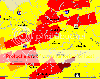
I don't remember seeing so many towns with multiple TOR warnings before. 
0 likes
-
brunota2003

- S2K Supporter

- Posts: 9476
- Age: 35
- Joined: Sat Jul 30, 2005 9:56 pm
- Location: Stanton, KY...formerly Havelock, NC
- Contact:


Re: HIGH Risk, March 2
I have never seen so much red on a map in my life...
0 likes
NOTICE: I cannot give an expert analysis. Most of my "observations" are made visually with the help of only vital information provided by public advisories.
-
Texas Snowman
- Storm2k Moderator
- Posts: 6197
- Joined: Fri Jan 25, 2008 11:29 am
- Location: Denison, Texas
My experience has been that when you get almost IMMEDIATE reports of extreme damage, multiple injuries, multiple fatalities....it's very, very, very bad.
Praying for the people of Kentucky...
Praying for the people of Kentucky...
0 likes
The above post and any post by Texas Snowman is NOT an official forecast and should not be used as such. It is just the opinion of the poster and may or may not be backed by sound meteorological data. It is NOT endorsed by any professional institution including storm2k.org. For official information, please refer to NWS products.


-
northjaxpro

- S2K Supporter
- Posts: 8900
- Joined: Mon Sep 27, 2010 11:21 am
- Location: Jacksonville, FL
Re:
Texas Snowman wrote:My experience has been that when you get almost IMMEDIATE reports of extreme damage, multiple injuries, multiple fatalities....it's very, very, very bad.
Praying for the people of Kentucky...
Amen! I am fearing the worst for so many people today.
0 likes
NEVER, EVER SAY NEVER in the tropics and weather in general, and most importantly, with life itself!!
________________________________________________________________________________________
Fay 2008 Beryl 2012 Debby 2012 Colin 2016 Hermine 2016 Julia 2016 Matthew 2016 Irma 2017 Dorian 2019
________________________________________________________________________________________
Fay 2008 Beryl 2012 Debby 2012 Colin 2016 Hermine 2016 Julia 2016 Matthew 2016 Irma 2017 Dorian 2019
-
CrazyC83
- Professional-Met

- Posts: 34315
- Joined: Tue Mar 07, 2006 11:57 pm
- Location: Deep South, for the first time!
Re: HIGH Risk, March 2
MESOSCALE DISCUSSION 0220
NWS STORM PREDICTION CENTER NORMAN OK
0513 PM CST FRI MAR 02 2012
AREAS AFFECTED...ERN KY INTO EXTREME SRN OH AND WRN WV
CONCERNING...TORNADO WATCH 58...62...
VALID 022313Z - 030015Z
THE SEVERE WEATHER THREAT FOR TORNADO WATCH 58...62...CONTINUES.
DAMAGING TORNADO OUTBREAK UNDERWAY ACROSS ERN KY WITH SEVERAL
SUPERCELLS LIKELY CONTAINING STRONG TO VIOLENT TORNADOES. SUPERCELL
OVER MORGAN COUNTY KY IS MOVING INTO LAWRENCE COUNTY AND LIKELY
CONTAINS A VERY DAMAGING TORNADO. THIS STORM SHOULD EVENTUALLY
CONTINUE EWD INTO WAYNE COUNTY WV.
SUPERCELLS MOVING THROUGH ERN KY WILL CONTINUE THROUGH AN
ENVIRONMENT VERY FAVORABLE FOR STRONG TO VIOLENT TORNADOES AS THE
LLJ STRENGTHENS TO IN EXCESS OF 60 KT. LAST VWP DATA FROM JACKSON KY
INDICATE VERY LARGE 0-1 KM HODOGRAPHS WITH STORM RELATIVE HELICITY
ON THE ORDER OF 800 M2/S2 AND 500 J/KG MLCAPE. THESE PARAMETERS
ALONG WITH THE DISCRETE NATURE OF THE CONVECTION WILL CONTINUE TO
PROMOTE A THREAT OF TORNADOES...VERY LARGE HAIL AND DAMAGING WIND
NEXT FEW HOURS.
..DIAL.. 03/02/2012
ATTN...WFO...RLX...JKL...ILN...LMK...
LAT...LON 36878526 37968444 38708275 37538224 36688402 36878526
0 likes
-
Texas Snowman
- Storm2k Moderator
- Posts: 6197
- Joined: Fri Jan 25, 2008 11:29 am
- Location: Denison, Texas
Dear Lord...
@alastormspotter: 'Mass casualties' in West Liberty KY."
@alastormspotter: 'Mass casualties' in West Liberty KY."
0 likes
The above post and any post by Texas Snowman is NOT an official forecast and should not be used as such. It is just the opinion of the poster and may or may not be backed by sound meteorological data. It is NOT endorsed by any professional institution including storm2k.org. For official information, please refer to NWS products.
-
brunota2003
- S2K Supporter
- Posts: 9476
- Age: 35
- Joined: Sat Jul 30, 2005 9:56 pm
- Location: Stanton, KY...formerly Havelock, NC
- Contact:
Re: HIGH Risk, March 2
Parents are okay...that cell went by to their south, but they got some pea sized hail from it. Another cell is marching toward them, so they might go under a 3rd warning within the next hour.
They said the first cell they had a LOT of wind with...the inflow. The second cell just moved to their south, and now has a large and dangerous tornado on the ground with it.
They said the first cell they had a LOT of wind with...the inflow. The second cell just moved to their south, and now has a large and dangerous tornado on the ground with it.
0 likes
-
Texas Snowman
- Storm2k Moderator
- Posts: 6197
- Joined: Fri Jan 25, 2008 11:29 am
- Location: Denison, Texas
Need to choose their words more carefully. There is no such a thing as a "nice debris ball."
-----
@breakingweather: "RT @wxalto: #TORNADO south of Louisa, KY about to cross into WV. Impressive hook with nice debris ball with this storm.TAKE COVER!
-----
@breakingweather: "RT @wxalto: #TORNADO south of Louisa, KY about to cross into WV. Impressive hook with nice debris ball with this storm.TAKE COVER!
0 likes
The above post and any post by Texas Snowman is NOT an official forecast and should not be used as such. It is just the opinion of the poster and may or may not be backed by sound meteorological data. It is NOT endorsed by any professional institution including storm2k.org. For official information, please refer to NWS products.
-
Texas Snowman
- Storm2k Moderator
- Posts: 6197
- Joined: Fri Jan 25, 2008 11:29 am
- Location: Denison, Texas
@CNNweather: "#TORNADO reported in CHATTANOOGA, TN! SEEK shelter! @robmarcianoCNN is in Ooltewah now with live coverage."
0 likes
The above post and any post by Texas Snowman is NOT an official forecast and should not be used as such. It is just the opinion of the poster and may or may not be backed by sound meteorological data. It is NOT endorsed by any professional institution including storm2k.org. For official information, please refer to NWS products.
-
CrazyC83
- Professional-Met
- Posts: 34315
- Joined: Tue Mar 07, 2006 11:57 pm
- Location: Deep South, for the first time!
Re: HIGH Risk, March 2
Watch the south this evening.
MESOSCALE DISCUSSION 0221
NWS STORM PREDICTION CENTER NORMAN OK
0541 PM CST FRI MAR 02 2012
AREAS AFFECTED...MUCH OF SRN-CNTRL-NERN AL / W-CNTRL AND NWRN GA /
FAR SERN TN
CONCERNING...TORNADO WATCH 59...61...63...
VALID 022341Z - 030145Z
THE SEVERE WEATHER THREAT FOR TORNADO WATCH
59...61...63...CONTINUES.
TORNADIC SUPERCELL POTENTIAL WILL CONTINUE TO INCREASE THIS EVENING
AND INTO THE EARLY OVERNIGHT HOURS ACROSS A LARGE PORTION OF AL AND
WRN-NWRN GA. ASIDE FROM THE THREAT OF TORNADOES /POTENTIALLY
SIGNIFICANT/...SUPERCELLS WILL ALSO POSE AN ACCOMPANYING DMGG
STRAIGHT-LINE WINDS RISK.
23Z SURFACE ANALYSIS SHOWS A LARGE UNIMPEDED WARM/MOIST SECTOR
ACROSS AL AND MOVING INTO WRN PARTS OF GA --AHEAD OF A DRYLINE OVER
NWRN MS. 3 HR CHANGE IN SURFACE TEMP/DEWPOINT SHOW A DECREASE OF
2-7 DEG F AND A 2 DEG F INCREASE...RESPECTIVELY. THE FORECAST
CONTINUED TREND IN LOWERING SURFACE SPREADS AND LESS SUBSTANTIAL
BOUNDARY LAYER MIXING WILL SEEMINGLY PROVE MORE FAVORABLE FOR LOW
LEVEL MESOCYCLONES. SLIGHT IMPROVEMENTS IN THE LOW LEVEL
THERMODYNAMIC PROFILE WILL ACCOMPANY A STRENGTHENING IN THE LLJ
/40-55 KTS/ FROM SWRN AND W-CNTRL AL NEWD INTO NRN GA IN THE NEXT
FEW HOURS. THIS WILL SET THE STAGE FOR A POSSIBLE NOCTURNAL TORNADO
EPISODE FROM CNTRL AND E-CNTRL AL NEWD INTO N-CNTRL GA. THIS
SCENARIO IS AT LEAST SUPPORTED TO A CERTAIN EXTENT BY THE LATEST
STORM-SCALE MODEL ENSEMBLE /SSEO/. AS SUCH...SCATTERED DISCRETE
SUPERCELLS WILL POSE AN ATTENDANT ISOLD TORNADO THREAT --WITH
PERHAPS A FEW STRONG TORNADOES WITH THE MORE INTENSE SUPERCELLS.
..SMITH.. 03/02/2012
ATTN...WFO...GSP...MRX...FFC...TAE...BMX...HUN...MOB...
LAT...LON 32598809 34718606 35228482 34928377 34058355 33468366
31108573 31158740 31898840 32598809
0 likes
-
cycloneye

- Admin

- Posts: 149503
- Age: 69
- Joined: Thu Oct 10, 2002 10:54 am
- Location: San Juan, Puerto Rico
Re: HIGH Risk, March 2
SEVERE THUNDERSTORM WARNING
TNC003-117-149-030015-
/O.NEW.KOHX.SV.W.0040.120302T2341Z-120303T0015Z/
BULLETIN - EAS ACTIVATION REQUESTED
SEVERE THUNDERSTORM WARNING
NATIONAL WEATHER SERVICE NASHVILLE TN
541 PM CST FRI MAR 2 2012
THE NATIONAL WEATHER SERVICE IN NASHVILLE HAS ISSUED A
* SEVERE THUNDERSTORM WARNING FOR...
SOUTHERN RUTHERFORD COUNTY IN MIDDLE TENNESSEE...
NORTHWESTERN BEDFORD COUNTY IN MIDDLE TENNESSEE...
NORTHEASTERN MARSHALL COUNTY IN MIDDLE TENNESSEE...
* UNTIL 615 PM CST
* AT 536 PM CST NATIONAL WEATHER SERVICE DOPPLER RADAR INDICATED A
SEVERE THUNDERSTORM CAPABLE OF PRODUCING DAMAGING WINDS IN EXCESS
OF 60 MPH. THE STORM WAS NEAR CHAPEL HILL...MOVING NORTHEAST AT 55
MPH.
* LOCATIONS IMPACTED INCLUDE...
MURFREESBORO...
PRECAUTIONARY/PREPAREDNESS ACTIONS...
PLEASE REPORT HAIL...STRONG WINDS OR WIND DAMAGE TO THE NATIONAL
WEATHER SERVICE BY CALLING TOLL FREE...1 8 7 7 6 3 3 6 7 7 2. DO NOT
STAY OUTDOORS IF YOU ARE IN THE PATH OF SEVERE THUNDERSTORMS.
A TORNADO WATCH REMAINS IN EFFECT UNTIL 900 PM FRIDAY EVENING FOR
CENTRAL TENNESSEE.
&&
LAT...LON 3559 8670 3563 8670 3570 8675 3571 8668
3572 8670 3575 8670 3577 8666 3579 8666
3579 8662 3580 8661 3581 8662 3591 8636
3572 8626
TIME...MOT...LOC 2342Z 245DEG 47KT 3572 8662
$$
04
0 likes
Visit the Caribbean-Central America Weather Thread where you can find at first post web cams,radars
and observations from Caribbean basin members Click Here
and observations from Caribbean basin members Click Here
-
Texas Snowman
- Storm2k Moderator
- Posts: 6197
- Joined: Fri Jan 25, 2008 11:29 am
- Location: Denison, Texas
Think he's near Chattanooga...
@robmarcianoCNN: "Tornado reported to my south. Im in hail core cannot see it."
@robmarcianoCNN: "Tornado reported to my south. Im in hail core cannot see it."
0 likes
The above post and any post by Texas Snowman is NOT an official forecast and should not be used as such. It is just the opinion of the poster and may or may not be backed by sound meteorological data. It is NOT endorsed by any professional institution including storm2k.org. For official information, please refer to NWS products.
Return to “USA & Caribbean Weather”
Who is online
Users browsing this forum: txtwister78 and 180 guests