LC thinks the heavens are going to open up Thursday through Sunday a long and east of I-35.
http://www.examiner.com/weather-in-hous ... rch-7-2012
Texas Spring 2012
Moderator: S2k Moderators
Forum rules

The posts in this forum are NOT official forecast and should not be used as such. They are just the opinion of the poster and may or may not be backed by sound meteorological data. They are NOT endorsed by any professional institution or STORM2K.
-
aggiecutter
- Category 5

- Posts: 1755
- Joined: Thu Oct 14, 2004 9:22 pm
- Location: Texarkana
Re: Texas Spring 2012
0 likes
-
Rgv20

- S2K Supporter

- Posts: 2466
- Age: 39
- Joined: Wed Jan 05, 2011 5:42 pm
- Location: Edinburg/McAllen Tx
0zGFS forecast rainfall totals thru 72hrs (ending Friday Evening) shows some decent rainfall totals for parts of Texas 
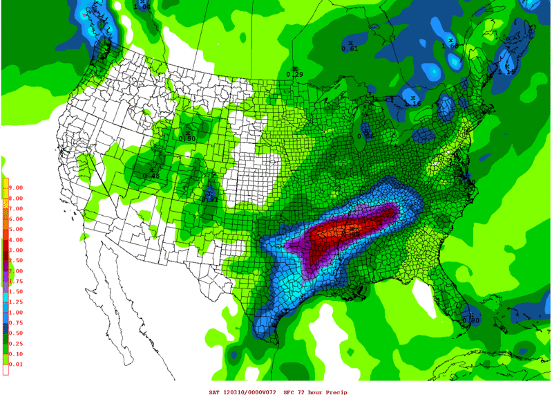
0 likes
The following post is NOT an official forecast and should not be used as such. It is just the opinion of the poster and may or may not be backed by sound meteorological data. It is NOT endorsed by any professional institution including storm2k.org For Official Information please refer to the NHC and NWS products.
-
Longhornmaniac8

- Category 1

- Posts: 261
- Joined: Thu Nov 18, 2010 2:30 am
- Location: Austin, TX
-
weatherdude1108
- Category 5
- Posts: 4228
- Joined: Tue Dec 13, 2011 1:04 pm
- Location: Northwest Austin/Cedar Park, TX
Re:
Longhornmaniac8 wrote:We're getting some really strong winds here in Austin right now. Could someone explain what's causing them?
Cheers!
A friend asked me that question. I believe it is the byproduct of the high pressure to the east southeast and the upper level low pressure to our northwest. Air tends to follow a path from higher pressure to lower pressure. We are in the middle of that path of air where the isobars of pressure from the high pressure and low pressure are converging. The resulting byproduct of this convergence of isobars is the wind. I guess this is the atmosphere's way of moving towards a state of dynamic equilibrium, but just guessing.
0 likes
-
wxman57

- Moderator-Pro Met

- Posts: 23175
- Age: 68
- Joined: Sat Jun 21, 2003 8:06 pm
- Location: Houston, TX (southwest)
Re:
Longhornmaniac8 wrote:We're getting some really strong winds here in Austin right now. Could someone explain what's causing them?
Cheers!
Of course, the stronger wind is a product of the sharper pressure gradient across the state (low to west, high to east). But what's happening at times is something that we occasionally see during the late winter and spring in particular. With the deepening upper-level trof to our west, the winds just above the surface (we call that the low-level jet) have increased dramatically. Winds 1000 feet up or so are in the 35-45 kt range (40-50 mph). Normally, this strong low-level jet remains elevated above the surface. But sometimes, and we're not sure what causes it, that low-level jet briefly dips down to the surface and produces some quite strong winds there. This happens more frequently at night than during the day, and it's more frequently a coastal event rather than over inland counties.
We think that the event may be triggered by the passage of a weak upper-level feature that tracks from west to east, as we can often track the dip in the low-level jet and resulting spike in surface winds from the lower TX coast to the upper TX coast over a 4-6 hour period.
0 likes
-
Portastorm

- Storm2k Moderator

- Posts: 9955
- Age: 63
- Joined: Fri Jul 11, 2003 9:16 am
- Location: Round Rock, TX
- Contact:
Re: Re:
weatherdude1108 wrote:Longhornmaniac8 wrote:We're getting some really strong winds here in Austin right now. Could someone explain what's causing them?
Cheers!
A friend asked me that question. I believe it is the byproduct of the high pressure to the east southeast and the upper level low pressure to our northwest. Air tends to follow a path from higher pressure to lower pressure. We are in the middle of that path of air where the isobars of pressure from the high pressure and low pressure are converging. The resulting byproduct of this convergence of isobars is the wind. I guess this is the atmosphere's way of moving towards a state of dynamic equilibrium, but just guessing.Maybe a pro met can chime in.
To add to weatherdude's comments, the low level jet was right overhead last night and part of yesterday which explained the high winds. Nocturnal low level jets are stronger as daylight fades into night. Here's some educational reading on it:
http://www.theweatherprediction.com/severe/llj/
0 likes
Any forecasts under my name are to be taken with a grain of salt. Get your best forecasts from the National Weather Service and National Hurricane Center.
-
aggiecutter
- Category 5
- Posts: 1755
- Joined: Thu Oct 14, 2004 9:22 pm
- Location: Texarkana
Re: Texas Spring 2012
12z GFS says deluge east of I-35 over the next 5 days.
http://mag.ncep.noaa.gov/NCOMAGWEB/appc ... mageSize=M
http://mag.ncep.noaa.gov/NCOMAGWEB/appc ... mageSize=M
0 likes
-
txwxpirate

- Tropical Low

- Posts: 45
- Joined: Tue Aug 30, 2011 9:39 am
Re: Texas Spring 2012
Here is the latest partial Houston NWS disco concerning rain in our area
TWO SIGNIFICANT THINGS I SEE MISSING ARE A LLVL
FOCUS/BOUNDARY AND SLOW STORM MOTION. NOT TO DISCOUNT THAT A
MESOSCALE/MICROSCALE SITUATION MIGHT END UP OCCURRING THAT WOULD
PRODUCE THESE...BUT AS THINGS STAND RIGHT NOW I JUST DON`T THE SEE
CONTINUOUS AND NEVER ENDING PRECIP FROM FRI-MONDAY MORNING
GFS/ECMWF ARE ADVERTISING. THINK THE CANADIAN LOOKS MOST REALISTIC.
SEEN SIMILAR FCST PATTERNS BOTH VERIFY AND BUST ACROSS SE TX.
LITTLE CHANGES IN TIMING, POSITIONING, MESOSCALE FACTORS AND RIDGE
STRENGTH OVER THE GULF COULD SIGNIFICANTLY ALTER THE OUTCOME. FOR
NOW WOULD JUST EXPECT PERIODS OF PRECIP THRU THE WEEKEND WITH
INTERMITTENT BREAKS IN THE ACTIVITY. WILL NEED TO BE MINDFUL OF
MOISTENING GROUND CONDITIONS THRU THE WEEKEND AND WILL HOPEFULLY
NAIL THINGS DOWN A BIT MORE IN THE NEXT FEW DAYS.
0 likes
Show Me That Horizon
Nassau Bay, Tx
Nassau Bay, Tx
-
Portastorm
- Storm2k Moderator
- Posts: 9955
- Age: 63
- Joined: Fri Jul 11, 2003 9:16 am
- Location: Round Rock, TX
- Contact:
Re: Texas Spring 2012
Here is part of the afternoon AFD from NWSFO Austin/San Antonio. This is their current take on the weekend:
GIVEN STRONG CONVERGENCE ALONG
THEE FRONT AND AMPLE ATMOSPHERIC MOISTURE...WE`VE INCLUDED A
MENTION OF LOCALLY HEAVY RAINFALL WITH THE FORECAST FOR THURSDAY
EVENING. LOCALLY HEAVY RAINFALL AMOUNTS OF 2-3 INCHES ARE POSSIBLE
ALONG AND EAST OF INTERSTATE 35 THURSDAY EVENING...WITH THE
GREATEST CHANCES OF THESE HIGHER AMOUNTS ALONG AND SOUTHEAST OF A
GIDDINGS TO GONZALES TO KENEDY LINE.
IN ADDITION TO THE LOCALLY HEAVY RAIN THREAT...A SLIGHT RISK FOR SEVERE
THUNDERSTORMS EXISTS BETWEEN 4PM AND 10PM ALONG AND IMMEDIATELY
BEHIND THE FRONT. THE MAIN THREAT AREA IS ALONG AND NORTHEAST OF A
LINE FROM LLANO TO NEW BRAUNFELS TO GIDDINGS. ALTHOUGH SB-CAPE
VALUES WILL NOT BE TOO IMPRESSIVE (1000-1500 J/KG)...A QUASI-
LINEAR CONVECTIVE MODE IS ANTICIPATED WITH STRONG CONVERGENCE ALONG
THE FRONT. GIVEN THIS AND THE TIMING AFTER MAX HEATING...IT
APPEARS THAT A DAMAGING WIND THREAT IS THE MOST LIKELY SEVERE
THREAT LATE THURSDAY...ALTHOUGH QUARTER SIZE HAIL CAN NOT BE
RULED-OUT.
MOVING ON INTO FRIDAY AND SATURDAY...RAIN CHANCES WILL CONTINUE
BEHIND THE FRONT WITH THE UPPER LOW COMPLETELY CUT-OFF OVER THE
TEXAS PANHANDLE. DIURNAL TEMPERATURE RANGES ON FRIDAY WILL BE 5
DEGREES AT MOST. EXPECT MORE OF THE SAME ON SATURDAY WITH A LITTLE
AIRMASS MODIFICATION ALLOWING FOR SLIGHTLY GREATER DIURNAL
TEMPERATURE RANGES.
THE 12Z MODEL SOLUTIONS HAVE COME INTO FAIRLY GOOD AGREEMENT ON
THE EVOLUTION OF A SECONDARY UPPER LOW OVER MEXICO ON
SATURDAY...THEN MOVING OVER SOUTH TEXAS ON SUNDAY. RAIN CHANCES
WILL CONTINUE INTO SUNDAY AND THEN SHIFT EAST OUT OF SOUTH CENTRAL
TEXAS. GULF MOISTURE WILL RETURN QUICKLY NEXT MON/TUE AND
TEMPERATURES WILL TREND UP ONCE AGAIN.
0 likes
Any forecasts under my name are to be taken with a grain of salt. Get your best forecasts from the National Weather Service and National Hurricane Center.

-
DFW Stormwatcher
- Tropical Storm

- Posts: 243
- Age: 55
- Joined: Sun Dec 27, 2009 10:35 pm
- Location: Keller, Tx
Re: Re:
Ntxw wrote:DFW Stormwatcher wrote:That map looks great to anyone on the North Texas Municipal water district system. That bull's eye is right over Lake Jim Chapman which is still at only 55% capacity and Lake Lavon is at 80%. So drought still exists for us in Collin County at least in terms of water use, as we are still under stage 3 restrictions since there hasn't been near as much rain to the northeast of DFW. NWS seems to be on the fence about the real heavy rain, so I guess the jury is still out on exactly how hefty the amounts will be. But obviously pulling for the Canadian, if we get that, I may be able to water my yard this summer.
Amounts for any one location or area won't be as important for drought relief. The key here is this is yet another widespread 2-3+ inches of rain for all of north, east, southeast Texas, that is how you beat drought area wide
There is a slight risk of severe weather pre-frontal. Dynamics do not look too impressive as compared to the flooding potential at this time.
Uploaded with ImageShack.us

Problem is Lake Jim Chapman and Lake Lavon are all we have right now in Collin County because of the zebra mussels in Lake Texoma we can't use that water source. There's been a lack of big rains for the sulphur river basin feeding into lake jim chapman as well, this time they are in the mix for getting some rain. So yes indeed, a big soaker will be great, but it does me no good for the summer if it isn't upstream from lake lavon and lake jim chapman. Soil is moist in Frisco now, but in july it won't be most likely, of course with La Nina wrapping up we can always hope for at least a normal summer as it pertains to rainfall.
0 likes
Disclaimer: This is not an official weather forecast. I am only an amateur weather enthusiast therefore any weather forecasts or opinions should be taken with a grain of salt. Hook em Horns!
-
Rgv20
- S2K Supporter
- Posts: 2466
- Age: 39
- Joined: Wed Jan 05, 2011 5:42 pm
- Location: Edinburg/McAllen Tx
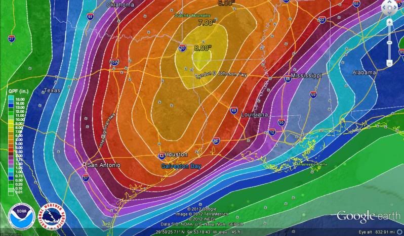
Here is a closer look at 0z 03/08 HPC Forecast Rainfall thru 5 days..
0 likes
The following post is NOT an official forecast and should not be used as such. It is just the opinion of the poster and may or may not be backed by sound meteorological data. It is NOT endorsed by any professional institution including storm2k.org For Official Information please refer to the NHC and NWS products.
-
weatherdude1108
- Category 5
- Posts: 4228
- Joined: Tue Dec 13, 2011 1:04 pm
- Location: Northwest Austin/Cedar Park, TX
Here's Bob Rose's latest take on the upcoming event. Very optimistic for widespread 2-4 inch rains in the Hill Country and Central Texas this weekend. Severe possibilities Thursday night.
http://www.lcra.org/water/conditions/we ... olumn.html
http://www.lcra.org/water/conditions/we ... olumn.html
0 likes
The preceding post is NOT an official forecast, and should not be used as such. It is only the opinion of the poster and may or may not be backed by sound meteorological data. It is NOT endorsed by any professional institution including storm2k.org. For Official Information please refer to the NHC and NWS products.
Soggy ... that's my forecast. 
I can't get over how green our yard was in January. (and greener now) Usually when I look at pics of our yard, Jan and July look the same, I have to look at the trees to tell the difference!
And I saw full grown bluebonnets along I35 and Mopac!!!!! Earliest I have ever seen them - normally it's the beginning of April...
0 likes
-
Rgv20
- S2K Supporter
- Posts: 2466
- Age: 39
- Joined: Wed Jan 05, 2011 5:42 pm
- Location: Edinburg/McAllen Tx
What a difference a day makes in my part of the world  Here is the forecast from the NWS in Brownsville for my area..
Today: Mostly cloudy, with a high near 91. Breezy, with a south wind between 23 and 25 mph, with gusts as high as 36 mph.
Friday: A 50 percent chance of showers and thunderstorms. Cloudy, with a high near 53. Windy, with a north northwest wind between 22 and 30 mph, with gusts as high as 41 mph.
From shorts to jacket weather in a blink of an eye!
0 likes
The following post is NOT an official forecast and should not be used as such. It is just the opinion of the poster and may or may not be backed by sound meteorological data. It is NOT endorsed by any professional institution including storm2k.org For Official Information please refer to the NHC and NWS products.
-
Tireman4

- S2K Supporter
- Posts: 5903
- Age: 60
- Joined: Fri Jun 30, 2006 1:08 pm
- Location: Humble, Texas
- Contact:
Re:
Rgv20 wrote:What a difference a day makes in my part of the world
Today: Mostly cloudy, with a high near 91. Breezy, with a south wind between 23 and 25 mph, with gusts as high as 36 mph.
Friday: A 50 percent chance of showers and thunderstorms. Cloudy, with a high near 53. Windy, with a north northwest wind between 22 and 30 mph, with gusts as high as 41 mph.
From shorts to jacket weather in a blink of an eye!
Welcome to Winter...I mean errr...Spring...or whatever...LOL
0 likes

Re: Texas Spring 2012
39 at the falls, 47 in weatherford, 70 one county over in ft worth, I'd say a cold front is out there lol. Though idk if it will cross houston today. Evening commute will def feel drastically different
0 likes
The above post and any post by Ntxw is NOT an official forecast and should not be used as such. It is just the opinion of the poster and may or may not be backed by sound meteorological data. It is NOT endorsed by any professional institution including Storm2k. For official information, please refer to NWS products.
Help support Storm2K!
-
vbhoutex

- Storm2k Executive

- Posts: 29149
- Age: 74
- Joined: Wed Oct 09, 2002 11:31 pm
- Location: Cypress, TX
- Contact:
Re: Texas Spring 2012
Ntxw wrote:39 at the falls, 47 in weatherford, 70 one county over in ft worth, I'd say a cold front is out there lol. Though idk if it will cross houston today. Evening commute will def feel drastically different
It is expected to cross our area very late this evening. Expecting "high" in the 50's with showers tomorrow. Ugh!!
0 likes
Skywarn, C.E.R.T.
Please click below to donate to STORM2K to help with the expenses of keeping the site going:

Please click below to donate to STORM2K to help with the expenses of keeping the site going:
Front came through, got water blasted walking between classes and colddd. I saw a lot of students wearing shorts and flip flops cause it was humid and warm this morning. What a difference, was a shock to the system for sure.
0 likes
The above post and any post by Ntxw is NOT an official forecast and should not be used as such. It is just the opinion of the poster and may or may not be backed by sound meteorological data. It is NOT endorsed by any professional institution including Storm2k. For official information, please refer to NWS products.
Help support Storm2K!
Help support Storm2K!
-
weatherdude1108
- Category 5
- Posts: 4228
- Joined: Tue Dec 13, 2011 1:04 pm
- Location: Northwest Austin/Cedar Park, TX
Since we're in a Spring weather forum, thought I'd share a storm chasing video I found on YouTube :
"5/30/2011 Large hail destroys car and funnel cloud and wall cloud B-Roll."
http://www.youtube.com/watch?v=XcHGliRR ... ata_player
"5/30/2011 Large hail destroys car and funnel cloud and wall cloud B-Roll."
http://www.youtube.com/watch?v=XcHGliRR ... ata_player
0 likes
Return to “USA & Caribbean Weather”
Who is online
Users browsing this forum: No registered users and 136 guests