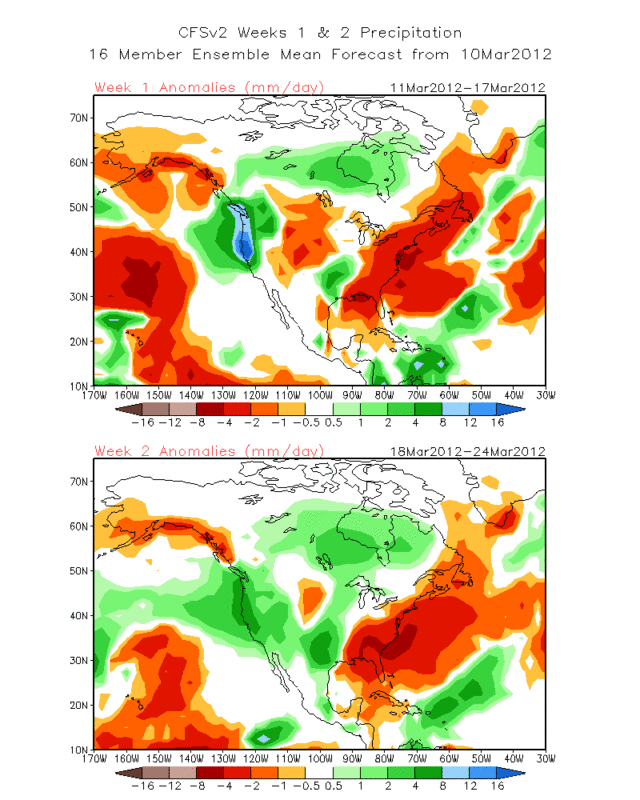
"Medium range forecasts still show rain chances increasing in the early part of the week of March 18 to March 24...as another disturbance is forecast to come across south central Texas from the west again."
Texas Spring 2012
Moderator: S2k Moderators
Forum rules

The posts in this forum are NOT official forecast and should not be used as such. They are just the opinion of the poster and may or may not be backed by sound meteorological data. They are NOT endorsed by any professional institution or STORM2K.
-
weatherdude1108
- Category 5

- Posts: 4228
- Joined: Tue Dec 13, 2011 1:04 pm
- Location: Northwest Austin/Cedar Park, TX
Saw a blurb in the 8:58 PM Austin/San Antonio discussion. Bring it! 
"Medium range forecasts still show rain chances increasing in the early part of the week of March 18 to March 24...as another disturbance is forecast to come across south central Texas from the west again."
"Medium range forecasts still show rain chances increasing in the early part of the week of March 18 to March 24...as another disturbance is forecast to come across south central Texas from the west again."
0 likes
The preceding post is NOT an official forecast, and should not be used as such. It is only the opinion of the poster and may or may not be backed by sound meteorological data. It is NOT endorsed by any professional institution including storm2k.org. For Official Information please refer to the NHC and NWS products.
-
Rgv20

- S2K Supporter

- Posts: 2466
- Age: 39
- Joined: Wed Jan 05, 2011 5:42 pm
- Location: Edinburg/McAllen Tx
0 likes
The following post is NOT an official forecast and should not be used as such. It is just the opinion of the poster and may or may not be backed by sound meteorological data. It is NOT endorsed by any professional institution including storm2k.org For Official Information please refer to the NHC and NWS products.
-
gboudx

- S2K Supporter
- Posts: 4090
- Joined: Thu Sep 04, 2003 1:39 pm
- Location: Rockwall, Tx but from Harvey, La
Re:
weatherdude1108 wrote:Saw a blurb in the 8:58 PM Austin/San Antonio discussion. Bring it!
"Medium range forecasts still show rain chances increasing in the early part of the week of March 18 to March 24...as another disturbance is forecast to come across south central Texas from the west again."
DFW TV met Steve McAuley brought it up on the weather segment last night. Said another upper low may dive down and provide Tx with another great shot at rain.
0 likes
-
wxman57

- Moderator-Pro Met

- Posts: 23175
- Age: 68
- Joined: Sat Jun 21, 2003 8:06 pm
- Location: Houston, TX (southwest)
Re: Re:
gboudx wrote:weatherdude1108 wrote:Saw a blurb in the 8:58 PM Austin/San Antonio discussion. Bring it!
"Medium range forecasts still show rain chances increasing in the early part of the week of March 18 to March 24...as another disturbance is forecast to come across south central Texas from the west again."
DFW TV met Steve McAuley brought it up on the weather segment last night. Said another upper low may dive down and provide Tx with another great shot at rain.
Maybe, but latest GFS and Euro indicate this upper low takes a track farther north - across southern CO/northern NM then NNE to the Northern Plains vs. across Texas. Could cause some severe storms across west to central TX around the middle of next week. Remember, models probably won't have a good handle on the event until late next weekend or so.
0 likes
-
weatherdude1108
- Category 5
- Posts: 4228
- Joined: Tue Dec 13, 2011 1:04 pm
- Location: Northwest Austin/Cedar Park, TX
The 3:05 pm discussion had this blurb at the very end. Only time will tell:
"THE 12Z GFS/ECMWF ARE SHOWING A SIGNIFICANT CONVECTIVE EVENT FOR
SOUTH CENTRAL TEXAS BY THE MIDDLE OF NEXT WEEK. STAY TUNED."
"THE 12Z GFS/ECMWF ARE SHOWING A SIGNIFICANT CONVECTIVE EVENT FOR
SOUTH CENTRAL TEXAS BY THE MIDDLE OF NEXT WEEK. STAY TUNED."
0 likes
The preceding post is NOT an official forecast, and should not be used as such. It is only the opinion of the poster and may or may not be backed by sound meteorological data. It is NOT endorsed by any professional institution including storm2k.org. For Official Information please refer to the NHC and NWS products.
-
gboudx
- S2K Supporter
- Posts: 4090
- Joined: Thu Sep 04, 2003 1:39 pm
- Location: Rockwall, Tx but from Harvey, La
Re: Re:
wxman57 wrote:gboudx wrote:weatherdude1108 wrote:Saw a blurb in the 8:58 PM Austin/San Antonio discussion. Bring it!
"Medium range forecasts still show rain chances increasing in the early part of the week of March 18 to March 24...as another disturbance is forecast to come across south central Texas from the west again."
DFW TV met Steve McAuley brought it up on the weather segment last night. Said another upper low may dive down and provide Tx with another great shot at rain.
Maybe, but latest GFS and Euro indicate this upper low takes a track farther north - across southern CO/northern NM then NNE to the Northern Plains vs. across Texas. Could cause some severe storms across west to central TX around the middle of next week. Remember, models probably won't have a good handle on the event until late next weekend or so.
McAuley is always careful to mention that what he's showing is a long-range model run and lots can change between now and then. And he'll mention what you say about when the models will have a good handle on the event. He's good at showing the public what the models are consistently showing in the long-range. He won't show a 384h Texas blizzard, for example.
0 likes
-
Rgv20
- S2K Supporter
- Posts: 2466
- Age: 39
- Joined: Wed Jan 05, 2011 5:42 pm
- Location: Edinburg/McAllen Tx
Re:
weatherdude1108 wrote:The 3:05 pm discussion had this blurb at the very end. Only time will tell:
"THE 12Z GFS/ECMWF ARE SHOWING A SIGNIFICANT CONVECTIVE EVENT FOR
SOUTH CENTRAL TEXAS BY THE MIDDLE OF NEXT WEEK. STAY TUNED."
Brownsville PM Discussion made a quick reference too..
''THE
PATTERN IS FORECAST TO AMPLIFY AND PROGRESS BY THE WEEKEND...WHICH
WILL PLACE MID LEVEL DIVERGENCE OVER CENTRAL TEXAS...BUT THE
IMPLICATIONS ARE TOO FAR IN THE FUTURE TO DRAW CONCLUSIONS FOR THE
BRO CWA.''
0 likes
The following post is NOT an official forecast and should not be used as such. It is just the opinion of the poster and may or may not be backed by sound meteorological data. It is NOT endorsed by any professional institution including storm2k.org For Official Information please refer to the NHC and NWS products.
-
TeamPlayersBlue

- Category 5
- Posts: 3531
- Joined: Tue Feb 02, 2010 1:44 am
- Location: Denver/Applewood, CO
Just finished my run. The humidity for the last couple days is RIDICULOUS. A little different from running in Yuma, AZ like i was for the last month.
0 likes
Personal Forecast Disclaimer:
The posts in this forum are NOT official forecast and should not be used as such. They are just the opinion of the poster and may or may not be backed by sound meteorological data. They are NOT endorsed by any professional institution or storm2k.org. For official information, please refer to the NHC and NWS products.
The posts in this forum are NOT official forecast and should not be used as such. They are just the opinion of the poster and may or may not be backed by sound meteorological data. They are NOT endorsed by any professional institution or storm2k.org. For official information, please refer to the NHC and NWS products.
-
Tireman4

- S2K Supporter
- Posts: 5903
- Age: 60
- Joined: Fri Jun 30, 2006 1:08 pm
- Location: Humble, Texas
- Contact:
Re:
TeamPlayersBlue wrote:Just finished my run. The humidity for the last couple days is RIDICULOUS. A little different from running in Yuma, AZ like i was for the last month.
Welcome to my world. That is why I am dreading my 7 miler right now. Yesterday, it was atrocious. I have the summer to look forward to. Lovely. Sigh.
0 likes
-
weatherdude1108
- Category 5
- Posts: 4228
- Joined: Tue Dec 13, 2011 1:04 pm
- Location: Northwest Austin/Cedar Park, TX
AREA FORECAST DISCUSSION
NATIONAL WEATHER SERVICE AUSTIN/SAN ANTONIO TX
304 PM CDT TUE MAR 13 2012
"THE OVERALL WEATHER PATTERN WILL CHANGE LITTLE
THROUGH FRIDAY WITH AN ACTIVE SUBTROPICAL JET ALOFT AND A CONTINUED SOUTHEAST INFLUX OF DEEP GULF MOISTURE. DISTURBANCES WILL TRACK ACROSS THE HILL COUNTRY WEDNESDAY NIGHT AND THURSDAY AND AN ENHANCEMENT OF THE LOW LEVEL JET WILL GIVE A CHANCE OF SHOWERS AND THUNDERSTORMS ACROSS THE HILL COUNTRY AND ADJACENT SECTIONS. SERRANIAS DEL BURRO OF MEXICO CONVECTION MAY OCCUR BY LATE FRIDAY AS LLJ'S ENHANCEMENT AND UPSLOPE MOISTURE AID IN DEVELOPMENT AND MAINTENANCE ACROSS THE REGION FRIDAY NIGHT. A CONTINUED SLIGHT CHANCE OF SHOWERS SATURDAY AND SUNDAY IN ENHANCED LLJ AND ACTIVE SOUTHWEST FLOW ALOFT. INCREASING CHANCES FOR SHOWERS AND STORMS BEGIN MONDAY AND TUESDAY AS THE PREFERRED EUROPEAN MODEL SHIFTS THE LARGE AND ELONGATED UPPER TROUGH EAST INTO THE SOUTHWEST U.S...WITH THE FORWARD SIDE OF THE JET BEGINNING TO IMPACT OUR WEATHER HERE IN SOUTH CENTRAL TEXAS. SHOWERS AND THUNDERSTORMS WILL INCREASE AS DISTURBANCES FROM THE STORM SYSTEM INTERACT WITH RICH GULF MOISTURE AND ENHANCE SERRANIAS DEL BURRO OF CONVECTION. THE BLOCKY RIDGE TO THE EAST COUPLED WITH ENERGY DIGGING INTO THE BASE OF THE MAMMOTH UPPER TROUGH TO THE WEST OF THE REGION WILL RESULT IN LITTLE TO NO MOVEMENT OF THE SYSTEM DURING THE LATTER PART OF NEXT WEEK...WITH A CONTINUED CHANCE OF THUNDERSTORMS WITH HEAVY RAINS AND POTENTIAL FLOOD PROBLEMS FOR THE AREA."
0 likes
The preceding post is NOT an official forecast, and should not be used as such. It is only the opinion of the poster and may or may not be backed by sound meteorological data. It is NOT endorsed by any professional institution including storm2k.org. For Official Information please refer to the NHC and NWS products.
-
Tireman4
- S2K Supporter
- Posts: 5903
- Age: 60
- Joined: Fri Jun 30, 2006 1:08 pm
- Location: Humble, Texas
- Contact:
Re: Re:
Tireman4 wrote:TeamPlayersBlue wrote:Just finished my run. The humidity for the last couple days is RIDICULOUS. A little different from running in Yuma, AZ like i was for the last month.
Welcome to my world. That is why I am dreading my 7 miler right now. Yesterday, it was atrocious. I have the summer to look forward to. Lovely. Sigh.
And just as I thought. I swear it is like a sauna at 79 degrees out there. Shoot. 7 miles in 52:30, but I swear, I am having to get ready for summer runs, not March. Sigh.
0 likes

If that kind of block does happen in northeastern North America, Texas could be in for quite a deluge with the next big system in a week or so as mentioned by some. That's quite a set up for rain this time of year (or any time of year aside from tropical systems). PNA is positive and should remain positive for awhile. Truly amazing what difference a year can be. I'm fairly certain summer of 2012 will be much nicer and closer to normal for Texas and not anything close to 2011 with the soil moisture.
0 likes
The above post and any post by Ntxw is NOT an official forecast and should not be used as such. It is just the opinion of the poster and may or may not be backed by sound meteorological data. It is NOT endorsed by any professional institution including Storm2k. For official information, please refer to NWS products.
Help support Storm2K!
-
Rgv20
- S2K Supporter
- Posts: 2466
- Age: 39
- Joined: Wed Jan 05, 2011 5:42 pm
- Location: Edinburg/McAllen Tx
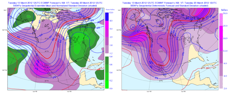
GFS and ECMWF Ensembles pretty much agree on the Ridge developing in the NE Part of the US but as always the details are really really unclear. The potential is there for parts of Texas to receive some heavy rain early to mid next week. As a side note the 12zECMWF has 5+inches rainfall totals for the Abilene and Wichita Falls area up to Central Oklahoma thru the next 10 days.
18zGFS Ensembles forecast valid for 03/20...The bright red colors represents the ridge in the NE United States and the blue color represents the trough.
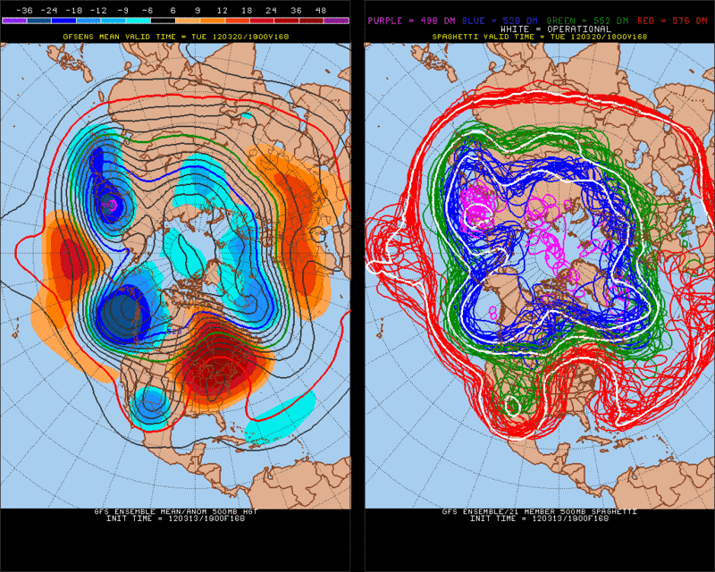
12zECMWF Ensembles forecast valid for 03/20....Ensembles pretty much agree on the ridge (Green Shading) but remain very uncertain as to what track the trough will take.
Like the good folks in the NWS's in Houston like to say "this Bears Watch"!!
18zGFS Ensembles forecast valid for 03/20...The bright red colors represents the ridge in the NE United States and the blue color represents the trough.
12zECMWF Ensembles forecast valid for 03/20....Ensembles pretty much agree on the ridge (Green Shading) but remain very uncertain as to what track the trough will take.
Like the good folks in the NWS's in Houston like to say "this Bears Watch"!!
0 likes
The following post is NOT an official forecast and should not be used as such. It is just the opinion of the poster and may or may not be backed by sound meteorological data. It is NOT endorsed by any professional institution including storm2k.org For Official Information please refer to the NHC and NWS products.
-
Texas Snowman

- Storm2k Moderator

- Posts: 6197
- Joined: Fri Jan 25, 2008 11:29 am
- Location: Denison, Texas
McAuley and others are chirping more and more in cyberspace about severe weather potential and flooding rain potential here in Texas over the weekend and next week.
Hail and tornado threat in the Panhandle on Sunday. Heavy rains in other portions of Texas after that.
This event appears to have loads of potential.
http://texasstormchasers.com/2012/03/14 ... arly-week/
Hail and tornado threat in the Panhandle on Sunday. Heavy rains in other portions of Texas after that.
This event appears to have loads of potential.
http://texasstormchasers.com/2012/03/14 ... arly-week/
0 likes
The above post and any post by Texas Snowman is NOT an official forecast and should not be used as such. It is just the opinion of the poster and may or may not be backed by sound meteorological data. It is NOT endorsed by any professional institution including storm2k.org. For official information, please refer to NWS products.
Re:
Texas Snowman wrote:McAuley and others are chirping more and more in cyberspace about severe weather potential and flooding rain potential here in Texas over the weekend and next week.
Hail and tornado threat in the Panhandle on Sunday. Heavy rains in other portions of Texas after that.
This event appears to have loads of potential.
http://texasstormchasers.com/2012/03/14 ... arly-week/
Completely agree with this thought. Very slow moving, powerful storm set up. Severe weather will be best as mentioned during the early onset of the system with a lot of jet energy especially in the panhandles, after that looks like a squall line will set up and sit from just west of the I-35 corridor and slide east slowly. Depending on the track of the ULL it could linger beyond as the storm wraps itself up and stall in the central plains. Given how the previous storm panned out I'm inclined to follow the Canadian, which paints a very wet picture!
0 likes
The above post and any post by Ntxw is NOT an official forecast and should not be used as such. It is just the opinion of the poster and may or may not be backed by sound meteorological data. It is NOT endorsed by any professional institution including Storm2k. For official information, please refer to NWS products.
Help support Storm2K!
Help support Storm2K!
-
Texas Snowman
- Storm2k Moderator
- Posts: 6197
- Joined: Fri Jan 25, 2008 11:29 am
- Location: Denison, Texas
Re: Re:
Ntxw wrote:Completely agree with this thought. Very slow moving, powerful storm set up. Severe weather will be best as mentioned during the early onset of the system with a lot of jet energy especially in the panhandles, after that looks like a squall line will set up and sit from just west of the I-35 corridor and slide east slowly. Depending on the track of the ULL it could linger beyond as the storm wraps itself up and stall in the central plains. Given how the previous storm panned out I'm inclined to follow the Canadian, which paints a very wet picture!
Texas Storm Chasers mentioned on their blog - while noting that the event is still several days out and nothing is etched in stone yet - that someone in the state might get in a narrow bull's-eye of HUGE rainfall totals if data verifies. To the tune of six to 10-inches.
If that DID happen, it might fill up some reservoirs and then some!
0 likes
The above post and any post by Texas Snowman is NOT an official forecast and should not be used as such. It is just the opinion of the poster and may or may not be backed by sound meteorological data. It is NOT endorsed by any professional institution including storm2k.org. For official information, please refer to NWS products.
-
Portastorm

- Storm2k Moderator
- Posts: 9955
- Age: 63
- Joined: Fri Jul 11, 2003 9:16 am
- Location: Round Rock, TX
- Contact:
Re: Texas Spring 2012
Conversely, the last couple of AFDs out of NWSFO Austin/San Antonio show less concern about Biblical rainfall and suggest a possible severe (flooding) event but one which is more transitory than initially thought, highlighting the Monday night/Tuesday morning period. 
0 likes
Any forecasts under my name are to be taken with a grain of salt. Get your best forecasts from the National Weather Service and National Hurricane Center.
-
Texas Snowman
- Storm2k Moderator
- Posts: 6197
- Joined: Fri Jan 25, 2008 11:29 am
- Location: Denison, Texas
Are these the same two NWSFOs that were worried about an arctic air intrusion a few weeks ago?
0 likes
The above post and any post by Texas Snowman is NOT an official forecast and should not be used as such. It is just the opinion of the poster and may or may not be backed by sound meteorological data. It is NOT endorsed by any professional institution including storm2k.org. For official information, please refer to NWS products.
-
Texas Snowman
- Storm2k Moderator
- Posts: 6197
- Joined: Fri Jan 25, 2008 11:29 am
- Location: Denison, Texas
Local TV Met Steve LaNore seems to be climbing aboard:
http://www.kxii.com/blogs/weatherblog/S ... 05175.html
"A slow-moving and very intense system presents both a severe storm and flood threat early next week for both sides of the Red River.
A very fast jet stream streaking eastward across the Pacific at 175 to 200 mph will provide the kinetic energy to carve out a huge trough which should extend from Canada to Mexico by Monday (see map).
Meanwhile, Pacific moisture at the mid levels and Gulf moisture in the lower levels will provide plenty of water vapor to make clouds and precipitation. The trough provides a large-scale lifting motion as it approaches, and very heavy rain may be the result. There’s also the potential for severe weather Mon-Tue. Here's the map:
Soaking rainfall last weekend came in with lower amounts than expected because drier air worked its way in from the east. There’s no dry air to be had with this system so the rainfall will probably be in the several-inch range. Surface temperatures will also be considerably warmer, providing more energy for thunderstorm formation.
This system bears close scrutiny as it begins to take shape in the days ahead.
Take Care,
Steve LaNore
Chief Meteorologist
KXII-TV
0 likes
The above post and any post by Texas Snowman is NOT an official forecast and should not be used as such. It is just the opinion of the poster and may or may not be backed by sound meteorological data. It is NOT endorsed by any professional institution including storm2k.org. For official information, please refer to NWS products.
-
TeamPlayersBlue
- Category 5
- Posts: 3531
- Joined: Tue Feb 02, 2010 1:44 am
- Location: Denver/Applewood, CO
Re: Re:
Tireman4 wrote:Tireman4 wrote:TeamPlayersBlue wrote:Just finished my run. The humidity for the last couple days is RIDICULOUS. A little different from running in Yuma, AZ like i was for the last month.
Welcome to my world. That is why I am dreading my 7 miler right now. Yesterday, it was atrocious. I have the summer to look forward to. Lovely. Sigh.
And just as I thought. I swear it is like a sauna at 79 degrees out there. Shoot. 7 miles in 52:30, but I swear, I am having to get ready for summer runs, not March. Sigh.
Yeah its been ridiculous. Today wasnt as bad but was still brutal. Feels like at least 85F but its only 74 degrees!
0 likes
Personal Forecast Disclaimer:
The posts in this forum are NOT official forecast and should not be used as such. They are just the opinion of the poster and may or may not be backed by sound meteorological data. They are NOT endorsed by any professional institution or storm2k.org. For official information, please refer to the NHC and NWS products.
The posts in this forum are NOT official forecast and should not be used as such. They are just the opinion of the poster and may or may not be backed by sound meteorological data. They are NOT endorsed by any professional institution or storm2k.org. For official information, please refer to the NHC and NWS products.
Return to “USA & Caribbean Weather”
Who is online
Users browsing this forum: No registered users and 113 guests