Texas Spring 2012
Moderator: S2k Moderators
Forum rules

The posts in this forum are NOT official forecast and should not be used as such. They are just the opinion of the poster and may or may not be backed by sound meteorological data. They are NOT endorsed by any professional institution or STORM2K.
-
somethingfunny

- ChatStaff

- Posts: 3926
- Age: 37
- Joined: Thu May 31, 2007 10:30 pm
- Location: McKinney, Texas
Hmm, we've been upgraded to a Slight Risk today from I-20 northward across the Red River. Visible satellite does show a storm may be building in Parker/PaloPinto County right now. Hail and downbursts might occur if you find yourself beneath one of these storms.
0 likes
I am not a meteorologist, and any posts made by me are not official forecasts or to be interpreted as being intelligent. These posts are just my opinions and are probably silly opinions.

Re: Texas Spring 2012
Nice drying period, next good chance of rain appears to be 6-8 days from now or late month/early April. All three major models depict a storm system traveling to the northern plains with subtropical disturbances crossing Texas. Long way out for any severe/rainfall parameters.
0 likes
The above post and any post by Ntxw is NOT an official forecast and should not be used as such. It is just the opinion of the poster and may or may not be backed by sound meteorological data. It is NOT endorsed by any professional institution including Storm2k. For official information, please refer to NWS products.
Help support Storm2K!
-
mcallum177
- Tropical Depression

- Posts: 98
- Joined: Sun Jun 14, 2009 12:39 am
- Location: Dallas, TX
Re: Texas Spring 2012
Hey it looks like the upper low is almost stacked, that is a pretty rare thing to see over TX right?
0 likes
-
weatherdude1108
- Category 5

- Posts: 4228
- Joined: Tue Dec 13, 2011 1:04 pm
- Location: Northwest Austin/Cedar Park, TX
Re: Texas Spring 2012
Ntxw wrote:Nice drying period, next good chance of rain appears to be 6-8 days from now or late month/early April. All three major models depict a storm system traveling to the northern plains with subtropical disturbances crossing Texas. Long way out for any severe/rainfall parameters.
Looks like the 8-14 day outlook discussion mentions that also. "...ENHANCED ODDS FOR ABOVE MEDIAN PRECIPITATION ARE FORECAST ALONG THE WEST COAST
AND ACROSS TEXAS,..." I only left in a couple paragraphs and highlighted the blurbs that stuck out in bold blue so you don't have to read the whole thing.
PROGNOSTIC DISCUSSION FOR 8 TO 14 DAY OUTLOOKS
NWS CLIMATE PREDICTION CENTER CAMP SPRINGS, MD
300 PM EDT WED MARCH 21 2012
8-14 DAY OUTLOOK FOR MAR 29 - APR 04, 2012
THE WEEK 2 ENSEMBLE MEAN MODEL FORECASTS FEATURE A TROUGH ALONG THE WEST COAST,
A RIDGE OVER THE CENTRAL CONUS, AND RETROGRESSION OF THE WESTERN ATLANTIC TROUGH TOWARDS THE EAST COAST. THE EXPECTED LONGWAVE PATTERN YIELDS A
CONTINUATION OF ABOVE NORMAL TEMPERATURES ACROSS THE GREAT PLAINS AND MIDWEST.
ENHANCED ODDS FOR ABOVE MEDIAN PRECIPITATION ARE FORECAST ALONG THE WEST COAST
AND ACROSS TEXAS, WHILE NEAR TO BELOW MEDIAN PRECIPITATION IS EXPECTED ACROSS
THE EASTERN THIRD OF THE CONUS.
A DIGGING TROUGH ALONG THE WEST COAST INCREASES THE CHANCES FOR ABOVE MEDIAN
PRECIPITATION IN CALIFORNIA. SHORTWAVE TROUGHS, EMERGING FROM THE TROUGH NEAR
THE WEST COAST, ENHANCE THE ODDS FOR ABOVE MEDIAN PRECIPITATION ACROSS THE
SOUTHERN PLAINS.
THE OFFICIAL 8-14 DAY HEIGHT PROG CONSISTS OF: 30 PERCENT OF TODAY'S 0Z GFS
ENSEMBLE MEAN CENTERED ON DAY 11...40 PERCENT OF TODAY'S 6Z GFS ENSEMBLE MEAN
CENTERED ON DAY 11...AND 30 PERCENT OF TODAY'S 0Z EUROPEAN ENSEMBLE MEAN
CENTERED ON DAY 11.
FORECAST CONFIDENCE FOR THE 8-14 DAY PERIOD IS: AVERAGE, 3 ON A SCALE FROM 1 TO
5, DUE TO GOOD AGREEMENT AMONG THE ENSEMBLE MEAN SOLUTIONS OFFSET BY
UNCERTAINTY IN THE TEMPERATURE OUTLOOK ACROSS THE EASTERN CONUS AND THE
EVOLUTION OF A TROUGH ALONG THE WEST COAST.
FORECASTER: BRAD PUGH
0 likes
The preceding post is NOT an official forecast, and should not be used as such. It is only the opinion of the poster and may or may not be backed by sound meteorological data. It is NOT endorsed by any professional institution including storm2k.org. For Official Information please refer to the NHC and NWS products.
Re: Texas Spring 2012
Portastorm wrote:Overall the event didn't live up to the hype (at least for us in AUS) ... no severe in Austin but the Portastorm Weather Center in scenic southwest Travis County received a little less than 3 inches which is cool! And, even better, the Hill Country got a lot of rain and the lakes will be rising some!
We got just about 3" at our house. I was happy no severe weather here.
0 likes
-
Rgv20

- S2K Supporter

- Posts: 2466
- Age: 39
- Joined: Wed Jan 05, 2011 5:42 pm
- Location: Edinburg/McAllen Tx
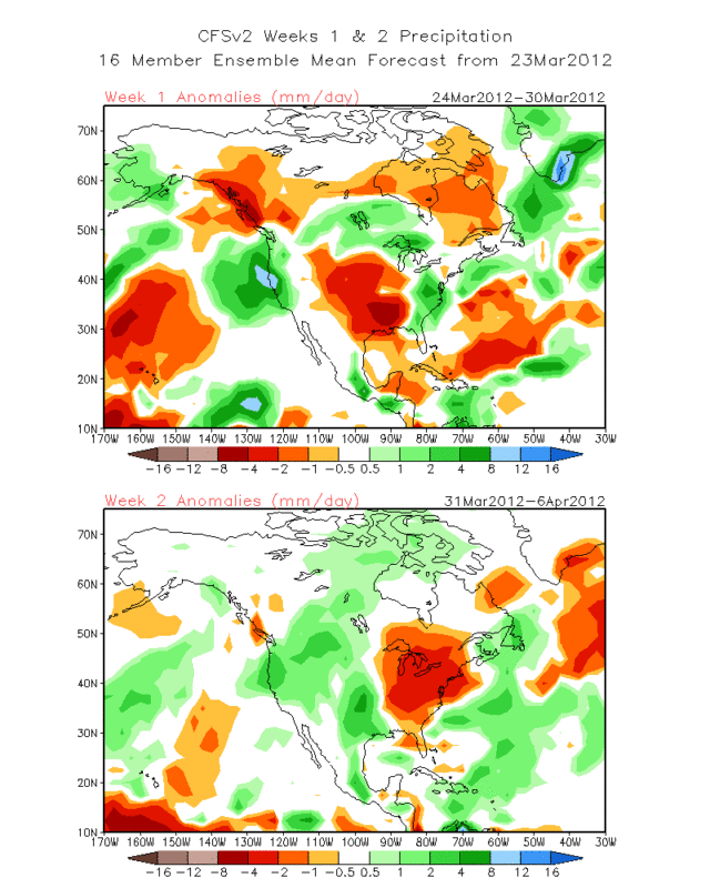
Another round of rain for central and Northern Texas?? CFSv2 seems to think so in the 8-14 day range (March 31 thru April 6). Also Thursday and Friday looks promising with regards to rain chances...we shall see.
0 likes
The following post is NOT an official forecast and should not be used as such. It is just the opinion of the poster and may or may not be backed by sound meteorological data. It is NOT endorsed by any professional institution including storm2k.org For Official Information please refer to the NHC and NWS products.
-
somethingfunny
- ChatStaff
- Posts: 3926
- Age: 37
- Joined: Thu May 31, 2007 10:30 pm
- Location: McKinney, Texas
So, what happened to Severe Season? March is supposed to be prime time for major storms to track across the Southern Plains... I haven't even been under a Severe Thunderstorm Warning since October! I'm getting antsy. 
0 likes
I am not a meteorologist, and any posts made by me are not official forecasts or to be interpreted as being intelligent. These posts are just my opinions and are probably silly opinions.

No cold air. Can't have severe weather outbreaks without clashes between hot and cold. Only warmth and humidity = tropical downpours and minor severe. GFS is advertising some cooler air masses come April but it may stay too cool for outbreaks.
2009 may be a good analog for this year as a whole weather wise.
2009 may be a good analog for this year as a whole weather wise.
0 likes
The above post and any post by Ntxw is NOT an official forecast and should not be used as such. It is just the opinion of the poster and may or may not be backed by sound meteorological data. It is NOT endorsed by any professional institution including Storm2k. For official information, please refer to NWS products.
Help support Storm2K!
Help support Storm2K!
-
somethingfunny
- ChatStaff
- Posts: 3926
- Age: 37
- Joined: Thu May 31, 2007 10:30 pm
- Location: McKinney, Texas
Yeah, I see that the pattern becomes more active in the second week of April on the GFS.... but it doesn't really look too impressive for Texas, more like the typical situation where we're capped and the dynamics explode (assuming it's warm enough) east of the Mississippi River. Surely there's SOMETHING down the pike. If nothing else, we can bank on a severe weather outbreak for the weekend of April 12-14, because that's when NASCAR holds its' events at Texas Motor Speedway. Every year it seems, there's a mad scramble to shelter 200,000 fans from their RVs as a tornado warned storm approaches the racetrack. Why they hold the event in April I'll never know. 
0 likes
I am not a meteorologist, and any posts made by me are not official forecasts or to be interpreted as being intelligent. These posts are just my opinions and are probably silly opinions.

Re:
somethingfunny wrote:Yeah, I see that the pattern becomes more active in the second week of April on the GFS.... but it doesn't really look too impressive for Texas, more like the typical situation where we're capped and the dynamics explode (assuming it's warm enough) east of the Mississippi River. Surely there's SOMETHING down the pike. If nothing else, we can bank on a severe weather outbreak for the weekend of April 12-14, because that's when NASCAR holds its' events at Texas Motor Speedway. Every year it seems, there's a mad scramble to shelter 200,000 fans from their RVs as a tornado warned storm approaches the racetrack. Why they hold the event in April I'll never know.
Not being overly familiar with Texas severe weather (2011 was my only year), why does it seem that we are always capped?? That always seems to be the thing working against us here. Growing up in Alabama I can only remember a couple of times where the cap inhibited storms...as a matter of fact I think some of the worst storms I can remember in Tuscaloosa and the rest of Alabama were when we had a cap but it always broke and that's when things got back...what's up with this Texas cap??
0 likes
Re: Re:
newtotex wrote:Not being overly familiar with Texas severe weather (2011 was my only year), why does it seem that we are always capped?? That always seems to be the thing working against us here. Growing up in Alabama I can only remember a couple of times where the cap inhibited storms...as a matter of fact I think some of the worst storms I can remember in Tuscaloosa and the rest of Alabama were when we had a cap but it always broke and that's when things got back...what's up with this Texas cap??
Storms like to form over the panhandles and west texas or the central plains (Colorado). That often puts a lot Texas in SW flow aloft. SW of Texas is Mexico and desert warmth/dry = cap. SW of places like Alabama is the Gulf of Mexico. I'm sure it's much more complicated than that. But when the cap does break you will get some of the most intense and awe-inspiring storms in the country imo
0 likes
The above post and any post by Ntxw is NOT an official forecast and should not be used as such. It is just the opinion of the poster and may or may not be backed by sound meteorological data. It is NOT endorsed by any professional institution including Storm2k. For official information, please refer to NWS products.
Help support Storm2K!
Help support Storm2K!
-
aggiecutter
- Category 5
- Posts: 1755
- Joined: Thu Oct 14, 2004 9:22 pm
- Location: Texarkana
Re: Texas Spring 2012
Looks like the next legitimate chance for severe weather will be early next week. The eastern part of Texas and the mid south look to be in the greatest threat area.
http://www.spc.noaa.gov/products/exper/day4-8/
http://www.spc.noaa.gov/products/exper/day4-8/
0 likes
Some discrepancies regarding early next week between the models. GFS and Canadian brings low pressure to Oklahoma/Red River valley and has showers and thunderstorms in east/southeast Texas. Euro is progressive hardly anything, Ukmet between the two options. Either way the deep south/Ohio Valley could be looking yet again another potential severe weather outbreak with east Texas in the western cross hairs.
0 likes
The above post and any post by Ntxw is NOT an official forecast and should not be used as such. It is just the opinion of the poster and may or may not be backed by sound meteorological data. It is NOT endorsed by any professional institution including Storm2k. For official information, please refer to NWS products.
Help support Storm2K!
Help support Storm2K!
-
Texas Snowman

- Storm2k Moderator

- Posts: 6197
- Joined: Fri Jan 25, 2008 11:29 am
- Location: Denison, Texas
I contend that the cap that is often in place is not a bad thing. We are, after all, at the bottom end of "Tornado Alley" and have had some super deadly storms in the past.
http://www.srh.noaa.gov/ama/?n=top10_tornadoes
And that list doesn't even include the Sherman tornado of May 15, 1896 when an F-5 tornado hit Sherman and killed 73.
http://www.srh.noaa.gov/ama/?n=top10_tornadoes
And that list doesn't even include the Sherman tornado of May 15, 1896 when an F-5 tornado hit Sherman and killed 73.
0 likes
The above post and any post by Texas Snowman is NOT an official forecast and should not be used as such. It is just the opinion of the poster and may or may not be backed by sound meteorological data. It is NOT endorsed by any professional institution including storm2k.org. For official information, please refer to NWS products.
-
Rgv20
- S2K Supporter
- Posts: 2466
- Age: 39
- Joined: Wed Jan 05, 2011 5:42 pm
- Location: Edinburg/McAllen Tx
Getting some nasty Tstorms here in the valley..

0 likes
The following post is NOT an official forecast and should not be used as such. It is just the opinion of the poster and may or may not be backed by sound meteorological data. It is NOT endorsed by any professional institution including storm2k.org For Official Information please refer to the NHC and NWS products.
-
Rgv20
- S2K Supporter
- Posts: 2466
- Age: 39
- Joined: Wed Jan 05, 2011 5:42 pm
- Location: Edinburg/McAllen Tx
Radar showing a possible tornado right in downtown McAllen! 
Tornado Warning
TORNADO WARNING
TXC215-300245-
/O.NEW.KBRO.TO.W.0004.120330T0209Z-120330T0245Z/
BULLETIN - EAS ACTIVATION REQUESTED
TORNADO WARNING
NATIONAL WEATHER SERVICE BROWNSVILLE TX
909 PM CDT THU MAR 29 2012
THE NATIONAL WEATHER SERVICE IN BROWNSVILLE HAS ISSUED A
* TORNADO WARNING FOR...
SOUTHERN HIDALGO COUNTY IN DEEP SOUTH TEXAS.
* UNTIL 945 PM CDT
* AT 909 PM CDT...NATIONAL WEATHER SERVICE METEOROLOGISTS WERE
TRACKING A TORNADO OVER MCALLEN...MOVING SOUTH AT 15 MPH.
* THE TORNADO WILL BE NEAR...
MCALLEN MILLER AIRPORT BY 910 PM CDT.
MADERO BY 915 PM CDT.
GRANJERO BY 925 PM CDT.
HIDALGO BY 930 PM CDT.
PRECAUTIONARY/PREPAREDNESS ACTIONS...
THIS IS A DANGEROUS STORM! MOVE INTO THE INTERIOR ROOM ON THE LOWEST
FLOOR OF A STURDY BUILDING...AWAY FROM WINDOWS. COVER YOUR HEAD AND
BODY WITH PILLOWS OR BLANKETS.
TORNADOES ARE ESPECIALLY DANGEROUS AT NIGHT. TAKE COVER NOW! MOVE TO
A SMALL INTERIOR ROOM ON THE LOWEST FLOOR. ABANDON MOBILE HOMES. IF
IN A VEHICLE AND THERE IS NO STURDY BUILDING NEARBY...PARK. CLOSE
WINDOWS...LEAVE SEATBELTS ON...GET LOWER THAN THE DASHBOARD...AND
COVER YOUR HEAD...PREFERABLY WITH BLANKETS OR PILLOWS. IF THERE IS NO
DEBRIS...LEAVE THE VEHICLE AND GO INTO A DITCH OR LOW SPOT...BUT
WATCH FOR RISING WATERS.
PLEASE REPORT TORNADOES OR FUNNEL CLOUDS...WINDS OF 58 MPH OR
HIGHER...HAIL THE SIZE OF PENNIES OR LARGER...AND ANY WIND DAMAGE TO
YOUR NATIONAL WEATHER SERVICE IN BROWNSVILLE BY CALLING 956-504-1432.
&&
LAT...LON 2605 9815 2606 9817 2605 9820 2607 9822
2607 9825 2610 9829 2612 9829 2610 9830
2610 9831 2615 9835 2615 9837 2632 9834
2630 9814
TIME...MOT...LOC 0209Z 006DEG 14KT 2619 9825
0 likes
The following post is NOT an official forecast and should not be used as such. It is just the opinion of the poster and may or may not be backed by sound meteorological data. It is NOT endorsed by any professional institution including storm2k.org For Official Information please refer to the NHC and NWS products.
-
Rgv20
- S2K Supporter
- Posts: 2466
- Age: 39
- Joined: Wed Jan 05, 2011 5:42 pm
- Location: Edinburg/McAllen Tx
Reports coming in of some pretty hefty damage in McAllen courtesy of Hail My uncle who lives in McAllen called me and said his work truck has taking a pounding...the mirrors are broken and the windshield is cracked....
EDIT: Looks like snow!!
Right in downtown McAllen!
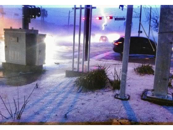
EDIT: Looks like snow!!
Right in downtown McAllen!
0 likes
The following post is NOT an official forecast and should not be used as such. It is just the opinion of the poster and may or may not be backed by sound meteorological data. It is NOT endorsed by any professional institution including storm2k.org For Official Information please refer to the NHC and NWS products.
-
vbhoutex

- Storm2k Executive

- Posts: 29149
- Age: 74
- Joined: Wed Oct 09, 2002 11:31 pm
- Location: Cypress, TX
- Contact:
Re: Texas Spring 2012
Has there been confirmation of the tornado yet by NWS? A friend's parents lost several windows in the home to the hail as well as multiple leaks from the roof. Also lost their mailbox that was anchored in concrete. They lived NW of downtown. Radar showed that storm just sitting over McAllen for at least an hour or more and I saw some reports of flash flooding going on too.
0 likes
Skywarn, C.E.R.T.
Please click below to donate to STORM2K to help with the expenses of keeping the site going:

Please click below to donate to STORM2K to help with the expenses of keeping the site going:
-
Rgv20
- S2K Supporter
- Posts: 2466
- Age: 39
- Joined: Wed Jan 05, 2011 5:42 pm
- Location: Edinburg/McAllen Tx
Re: Texas Spring 2012
vbhoutex wrote:Has there been confirmation of the tornado yet by NWS? A friend's parents lost several windows in the home to the hail as well as multiple leaks from the roof. Also lost their mailbox that was anchored in concrete. They lived NW of downtown. Radar showed that storm just sitting over McAllen for at least an hour or more and I saw some reports of flash flooding going on too.
No confirmed tornado just hail and more hail...We will know more this afternoon as the NWS in Brownsville just sent a team to survey the damage. Talked to a coworker earlier this morning and he said there are multiple trees down and the ones that were left standing are stripped of the leafs in 10th street and Nolana in McAllen. Oh and a lot of dead beards in the streets and as of 8:30am there was still some hail on the ground!
000
NWUS54 KBRO 300508
LSRBRO
PRELIMINARY LOCAL STORM REPORT...SUMMARY
NATIONAL WEATHER SERVICE BROWNSVILLE TX
1207 AM CDT FRI MAR 30 2012
..TIME... ...EVENT... ...CITY LOCATION... ...LAT.LON...
..DATE... ....MAG.... ..COUNTY LOCATION..ST.. ...SOURCE....
..REMARKS..
0500 PM HAIL 10 S SARITA 27.07N 97.80W
03/29/2012 E0.88 INCH KENEDY TX OTHER FEDERAL
DIME TO NICKEL SIZED HAIL ON HIGHWAY 77 REPORTED BY
BORDER PATROL
0725 PM HAIL 20 W SAN MANUEL 26.57N 98.44W
03/29/2012 E1.50 INCH STARR TX LAW ENFORCEMENT
HIDALGO S.O. RELAYED REPORT OF 1.5 INCH HAIL 12W OF SAN
ISIDRO FROM GENERAL PUBLIC.
0839 PM HAIL 6 WNW EDINBURG 26.33N 98.25W
03/29/2012 M0.88 INCH HIDALGO TX TRAINED SPOTTER
TRAINED SKYWARN SPOTTER REPORTED NICKEL SIZE HAIL
COVERING HALF OF GROUND. TEN MINUTES OF INTENSE HAIL
WITH LEAVES STRIPPED OFF THE TREES.
0845 PM HAIL EDINBURG 26.30N 98.16W
03/29/2012 M1.75 INCH HIDALGO TX BROADCAST MEDIA
RELAYED REPORT FROM KRGV CHANNEL 5... TWO REPORTS OF
GOLFBALL SIZE HAIL NEAR EDINBURG. 1 MILE NORTH OF HWY
107 AND DECO RD 835-845PM AND 107 AND WARE AT 850 PM
0858 PM HAIL EDINBURG 26.30N 98.16W
03/29/2012 M1.75 INCH HIDALGO TX AIRPLANE PILOT
REPORTED GOLFBALL SIZE A FEW POSSIBLE LARGER.
0900 PM HAIL MCALLEN 26.22N 98.24W
03/29/2012 E1.00 INCH HIDALGO TX PUBLIC
PUBLIC REPORTED QUARTER SIZE HAIL SOME POSSIBLY LARGER.
0903 PM HAIL MISSION 26.21N 98.32W
03/29/2012 M1.25 INCH HIDALGO TX PUBLIC
GENERAL PUBLIC REPORTED HAIL QUARTER TO HALF DOLLAR
SIZE AT LA HOMA RD MONTE CHRISTO
0904 PM TSTM WND GST MCALLEN 26.22N 98.24W
03/29/2012 M74 MPH HIDALGO TX ASOS
MCALLEN MILLER AIRPORT ASOS PEAK WIND GUSTS AT MINIMAL
HURRICANE FORCE
0905 PM HAIL MISSION 26.21N 98.32W
03/29/2012 M1.75 INCH HIDALGO TX TRAINED SPOTTER
SKYWARN DISTRICT 3 S SHARY ROAD GOLFBALL SIZE HAIL AND
40 MPH WIND WITH HIGHER GUSTS. LARGE TREE BRANCHES DOWN.
0920 PM HAIL MISSION 26.21N 98.32W
03/29/2012 E1.75 INCH HIDALGO TX PUBLIC
PUBLIC REPORTED GOLF BALL SIZE HAIL AT FAIRWAY AND
BRYAN. WINDS BLOWING PARTS OF ROOFS OFF.
0920 PM HAIL 2 N MCALLEN 26.24N 98.24W
03/29/2012 M1.00 INCH HIDALGO TX PUBLIC
WINDOWS BROKEN WITH QUARTER SIZE HAIL.
0924 PM HAIL MCALLEN 26.22N 98.24W
03/29/2012 M1.75 INCH HIDALGO TX PUBLIC
SEVERAL WINDOWS IN APARTMENT BROKEN HAIL PILING UP TO 6
INCHES.
0929 PM HAIL MCALLEN 26.22N 98.24W
03/29/2012 E1.00 INCH HIDALGO TX PUBLIC
QUARTER SIZE HAIL NEAR DOCTORS HOSPITAL. STREET
FLOODING OBSERVERD.
0931 PM HAIL MISSION 26.21N 98.32W
03/29/2012 E0.88 INCH HIDALGO TX PUBLIC
PUBLIC REPORT OF NICKEL SIZE HAIL IN SHARYLAND.
0947 PM HAIL MCALLEN 26.22N 98.24W
03/29/2012 E1.00 INCH HIDALGO TX PUBLIC
SMALL TOWN OF EL MANANA REPORTED QUARTER SIZE HAIL
0949 PM HAIL 4 N MCALLEN 26.27N 98.24W
03/29/2012 M1.00 INCH HIDALGO TX PUBLIC
6 INCH DEEP HAIL UP TO QUARTER SIZE AT NOLANA AND WARE
RD. BROKEN WINDOWS
1000 PM HAIL MISSION 26.21N 98.32W
03/29/2012 M1.00 INCH HIDALGO TX PUBLIC
PUBLIC REPORTED LARGE HAIL AND SHEET METAL FLYING.
STRONG WINDS TORNADO WARNING IN EFFECT.
1000 PM HAIL MCALLEN 26.22N 98.24W
03/29/2012 E2.75 INCH HIDALGO TX PUBLIC
PUBLIC REPORTED THAT BASEBALL SIZE HAIL OCCURRED IN
MCALLEN AT THE CORNER OF HARVEY AND 16TH STREET AT
AROUND 10 PM AT CALVARY BAPTIST CHURCH. 10 VEHICLES
SEVERELY DAMAGED.
1015 PM FLASH FLOOD MCALLEN 26.22N 98.24W
03/29/2012 HIDALGO TX TRAINED SPOTTER
6 INCHES OF RAIN REPORTED AT 4TH AND GLASSCOCK IN
SHARYLAND. WATER DEPTH OF UP TO 1.5 FEET ON ROAD...WAVES
PRODUCED BY DRIVERS PUSHING INTO HOMES.
1026 PM FLASH FLOOD MCALLEN 26.22N 98.24W
03/29/2012 HIDALGO TX PUBLIC
PUBLIC REPORTED 4 FEET OF WATER ON WARE... NOLANA...
AND BICENTENNIAL ROAD IN MCALLEN. ALSO DENSE FOG
LIMITING VISIBILITY TO 5 FEET OR LESS DUE TO HAIL
DRIFTS.
&&
0 likes
The following post is NOT an official forecast and should not be used as such. It is just the opinion of the poster and may or may not be backed by sound meteorological data. It is NOT endorsed by any professional institution including storm2k.org For Official Information please refer to the NHC and NWS products.
Return to “USA & Caribbean Weather”
Who is online
Users browsing this forum: No registered users and 125 guests