Texas Spring 2012
Moderator: S2k Moderators
Forum rules

The posts in this forum are NOT official forecast and should not be used as such. They are just the opinion of the poster and may or may not be backed by sound meteorological data. They are NOT endorsed by any professional institution or STORM2K.
-
Portastorm

- Storm2k Moderator

- Posts: 9955
- Age: 63
- Joined: Fri Jul 11, 2003 9:16 am
- Location: Round Rock, TX
- Contact:
Re: Texas Spring 2012
Glad you're ok Rgv20 ... I was wondering about you. What a hellatious storm!! 
0 likes
Any forecasts under my name are to be taken with a grain of salt. Get your best forecasts from the National Weather Service and National Hurricane Center.
-
vbhoutex

- Storm2k Executive

- Posts: 29149
- Age: 74
- Joined: Wed Oct 09, 2002 11:31 pm
- Location: Cypress, TX
- Contact:
Re: Texas Spring 2012
vbhoutex wrote:Has there been confirmation of the tornado yet by NWS? A friend's parents lost several windows in the home to the hail as well as multiple leaks from the roof. Also lost their mailbox that was anchored in concrete. They lived NW of downtown. Radar showed that storm just sitting over McAllen for at least an hour or more and I saw some reports of flash flooding going on too.
NWS is assessing this morning. Report out this afternoon.
0 likes
Skywarn, C.E.R.T.
Please click below to donate to STORM2K to help with the expenses of keeping the site going:

Please click below to donate to STORM2K to help with the expenses of keeping the site going:
-
Portastorm
- Storm2k Moderator
- Posts: 9955
- Age: 63
- Joined: Fri Jul 11, 2003 9:16 am
- Location: Round Rock, TX
- Contact:
Re: Texas Spring 2012
Concern appears to be growing for South Central Texas later today and the possibility of severe weather.
AREA FORECAST DISCUSSION
NATIONAL WEATHER SERVICE AUSTIN/SAN ANTONIO TX
1108 AM CDT FRI MAR 30 2012
.DISCUSSION...
CONCERN OVER RAPID CLEARING...GRAVITY WAVES/OUTFLOW MOVING SOUTH
FROM STORMS IN NORTH TEXAS...AND A WEAK TROUGH OVER THE BIG BEND
ARE ENOUGH TO UPDATE THE FORECAST TO INCLUDE POPS FOR THE ENTIRE
CWA...AND MENTION OF SEVERE/HEAVY RAIN OVER THE HILL COUNTRY IN
LINE WITH THE EARLY MORNING SPC OUTLOOK. THE SPC MESOANALYSIS PAGE
PROGS SHOW THE CAP GREATLY DIMINISHING WITH TIME...LEAVING ROUGHLY
2000-3000 J/KG OF MLCAPE AND STEEP 500-700 MB LAPSE RATES IN EXCESS
OF 7 C/KM THIS AFTERNOON. 0-6 KM BULK SHEAR IS 15 M/S OR
LESS...AND STORM MOTION PROJECTED TO BE QUITE SLOW...SO THE MAIN
MODE SHOULD BE STRONG PULSE STORMS...AND HENCE MAIN THREATS OF
LARGE HAIL AND LOCALLY HEAVY RAIN...AND A SECONDARY THREAT OF
DAMAGING WINDS. CONDITIONS MAY BE RIGHT FOR ONE OR TWO
SUPERCELLS...BUT EXPECT THE PRIMARY THREAT TO BE GOLFBALL OR
LARGER HAIL WITH THOSE STORMS
0 likes
Any forecasts under my name are to be taken with a grain of salt. Get your best forecasts from the National Weather Service and National Hurricane Center.
-
Rgv20

- S2K Supporter

- Posts: 2466
- Age: 39
- Joined: Wed Jan 05, 2011 5:42 pm
- Location: Edinburg/McAllen Tx
Re: Texas Spring 2012
Portastorm wrote:Glad you're ok Rgv20 ... I was wondering about you. What a hellatious storm!!
More like hailatious storm.....Where I live (upper valley) it was more of a very heavy rain and wind event. It looks like tonight their is another descent chance of some Tstorms hopefully nothing severe.
.SHORT TERM /TONIGHT THROUGH SATURDAY NIGHT/...THE ATMOSPHERE IS
DESTABILIZING AGAIN AFTER LAST NIGHT`S MCS DEPARTED AND DAYTIME
HEATING KICKED IN. UPPER DYNAMICS AGAIN FAVOR SHOWER AND TSTM
ACTIVITY TONIGHT. MAIN FOCUS FOR THUNDERSTORMS LOOKS TO BE THE
WESTERN VALLEY THIS EVENING AS TSTMS DEVELOP ON THE MOUNTAINS IN
MEXICO AND ARE PUSHED SOUTHEAST. STORM MOTION LOOKS TO BE FASTER
THAN YESTERDAY...SO TSTMS WILL NOT SETTLE OVER ONE LOCATION FOR
LONGER PERIODS.
Looks like daytime heating wont be a problem with the current temperature of 85 with mostly clear skies and a forecast high of low 90s.
0 likes
The following post is NOT an official forecast and should not be used as such. It is just the opinion of the poster and may or may not be backed by sound meteorological data. It is NOT endorsed by any professional institution including storm2k.org For Official Information please refer to the NHC and NWS products.

Indeed short range models (RUC/HRRR) do suggest some formation of rather intense supercells western north Texas, hill country, and even south Texas in a few hours. Scattered in nature though, but being underneath a slow moving one could be nasty hail producers.

0 likes
The above post and any post by Ntxw is NOT an official forecast and should not be used as such. It is just the opinion of the poster and may or may not be backed by sound meteorological data. It is NOT endorsed by any professional institution including Storm2k. For official information, please refer to NWS products.
Help support Storm2K!
-
Rgv20
- S2K Supporter
- Posts: 2466
- Age: 39
- Joined: Wed Jan 05, 2011 5:42 pm
- Location: Edinburg/McAllen Tx
http://www.srh.noaa.gov/bro/?n=2012even ... hailprelim
Historic Hail!
Mid Valley Blitzed by Hours of Hail, Wind, Flooding March 29th
Event
Intense thunderstorms raked the highly populated McAllen/Edinburg/Mission area of Hidalgo County during the mid evening of March 29th. The storms dumped hail up the size of baseballs for more than half an hour, drove that hail with 70 to 75 mph winds, added 4 to 6 inches of torrential rains, and produced frequent cloud to ground lightning. Initial storms developed across the King Ranch during the mid afternoon of March 29th, and spread west into northern Hidalgo and Starr County by early evening. The storms, fed by warm, humid air near the surface, colder air aloft, and boundaries (providing lift) from earlier storms which moved across the Coastal Bend, appeared to have intensified further as they approached the highly populated Edinburg/McAllen/Mission area. Why they intensified was a mystery, but one possibility was the interaction with an upper level disturbance moving across northeast Mexico. This disturbance spawned dangerous storms in Nuevo Léon and Tamaulipas, and boundaries from these cells may have been the ultimate trigger to a night hundreds of thousands will not forget.
Impact
The City of McAllen won’t soon forget the scary evening of March 29th. The following is a sampling of the damage and devastation experienced by many, particularly in the north half of the city (map, below):
Wind and Hail. In a small portion of north McAllen (red square, below), up to an hour of continuous hail, driven by frequent winds estimated at 70 to 75 mph, knocked at least one window out of every north–facing home, defoliated nearly every tree, left up to a half foot of accumulated hail on the ground, and produced hail drifts up to 4 feet high. Numerous tree limbs were blown down, many homes had roof damage, and broken glass and water littered the north facing rooms and apartments. Hundreds of vehicles left outdoors were severely damaged by golf ball to baseball size hail dents, including many shattered windows.
At the McAllen/Miller Airport, a wind gust to hurricane force – 74 mph – was recorded, which came from the northwest. Surrounding the hardest hit areas, locations in central McAllen to the edge of Edinburg received less hail and wind, but still enough to strip many leaves from trees, knock down fences, dent vehicles, and damage some windows and roofs.
Flooding and Rain. Torrential rain accompanied the hail; 4 to more than 6 inches fell in less than two hours, creating ice and water "rivers" with the height of the water as high as 4 to 6 feet in poor drainage locations. More than 100 vehicles were submerged and numerous others were abandoned during the peak of the storm. At one point, the city’s interconnected system of pipes, sewers, and drainage pools reached more than 90 percent of capacity. At one point, most of the city roads were under water.
Other. Frequent to excessive lightning was common with the long duration storm. At least two apartment fires were preliminarily attributed to lightning strikes. Many residents noted lightning streaking across the sky from north to south, indicative of impressive positive and negative charge distribution through the depth of the storm. Pockets of steam quickly formed as hail began to melt, and rose above eye level reducing visibility to near zero.
Assessment and Aftermath. For McAllen, the storm was epic. Given the magnitude, the community is fortunate to have escaped with no serious injuries and no fatalities as of this writing. Reasons may include time of day (mid to late evening), proactive services by the City’s Emergency Management apparatus, and good luck. In all, 217 persons were rescued from being trapped in hail and wind damaged homes and flood waters and more than 25,000 customers were without power during the peak of the storm. Insured and uninsured damages may tally $100 million – or more.
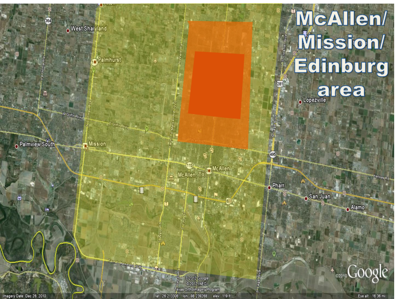
Image showing locations of increasingly intense damage in McAllen/Edinburg/Mission. Yellow shading indicates scattered wind damage (trees and some older buildings) with minimal hail impact; Orange shading indicates moderate hail impact and scattered wind damage; Red shading indicates severe hail impact (driven by the winds). Significant flooding occurred in all shaded areas.
Historic Hail!
Mid Valley Blitzed by Hours of Hail, Wind, Flooding March 29th
Event
Intense thunderstorms raked the highly populated McAllen/Edinburg/Mission area of Hidalgo County during the mid evening of March 29th. The storms dumped hail up the size of baseballs for more than half an hour, drove that hail with 70 to 75 mph winds, added 4 to 6 inches of torrential rains, and produced frequent cloud to ground lightning. Initial storms developed across the King Ranch during the mid afternoon of March 29th, and spread west into northern Hidalgo and Starr County by early evening. The storms, fed by warm, humid air near the surface, colder air aloft, and boundaries (providing lift) from earlier storms which moved across the Coastal Bend, appeared to have intensified further as they approached the highly populated Edinburg/McAllen/Mission area. Why they intensified was a mystery, but one possibility was the interaction with an upper level disturbance moving across northeast Mexico. This disturbance spawned dangerous storms in Nuevo Léon and Tamaulipas, and boundaries from these cells may have been the ultimate trigger to a night hundreds of thousands will not forget.
Impact
The City of McAllen won’t soon forget the scary evening of March 29th. The following is a sampling of the damage and devastation experienced by many, particularly in the north half of the city (map, below):
Wind and Hail. In a small portion of north McAllen (red square, below), up to an hour of continuous hail, driven by frequent winds estimated at 70 to 75 mph, knocked at least one window out of every north–facing home, defoliated nearly every tree, left up to a half foot of accumulated hail on the ground, and produced hail drifts up to 4 feet high. Numerous tree limbs were blown down, many homes had roof damage, and broken glass and water littered the north facing rooms and apartments. Hundreds of vehicles left outdoors were severely damaged by golf ball to baseball size hail dents, including many shattered windows.
At the McAllen/Miller Airport, a wind gust to hurricane force – 74 mph – was recorded, which came from the northwest. Surrounding the hardest hit areas, locations in central McAllen to the edge of Edinburg received less hail and wind, but still enough to strip many leaves from trees, knock down fences, dent vehicles, and damage some windows and roofs.
Flooding and Rain. Torrential rain accompanied the hail; 4 to more than 6 inches fell in less than two hours, creating ice and water "rivers" with the height of the water as high as 4 to 6 feet in poor drainage locations. More than 100 vehicles were submerged and numerous others were abandoned during the peak of the storm. At one point, the city’s interconnected system of pipes, sewers, and drainage pools reached more than 90 percent of capacity. At one point, most of the city roads were under water.
Other. Frequent to excessive lightning was common with the long duration storm. At least two apartment fires were preliminarily attributed to lightning strikes. Many residents noted lightning streaking across the sky from north to south, indicative of impressive positive and negative charge distribution through the depth of the storm. Pockets of steam quickly formed as hail began to melt, and rose above eye level reducing visibility to near zero.
Assessment and Aftermath. For McAllen, the storm was epic. Given the magnitude, the community is fortunate to have escaped with no serious injuries and no fatalities as of this writing. Reasons may include time of day (mid to late evening), proactive services by the City’s Emergency Management apparatus, and good luck. In all, 217 persons were rescued from being trapped in hail and wind damaged homes and flood waters and more than 25,000 customers were without power during the peak of the storm. Insured and uninsured damages may tally $100 million – or more.
Image showing locations of increasingly intense damage in McAllen/Edinburg/Mission. Yellow shading indicates scattered wind damage (trees and some older buildings) with minimal hail impact; Orange shading indicates moderate hail impact and scattered wind damage; Red shading indicates severe hail impact (driven by the winds). Significant flooding occurred in all shaded areas.
0 likes
The following post is NOT an official forecast and should not be used as such. It is just the opinion of the poster and may or may not be backed by sound meteorological data. It is NOT endorsed by any professional institution including storm2k.org For Official Information please refer to the NHC and NWS products.
-
Rgv20
- S2K Supporter
- Posts: 2466
- Age: 39
- Joined: Wed Jan 05, 2011 5:42 pm
- Location: Edinburg/McAllen Tx
There is a Severe Thunderstorm Warning just west of my area...Looks like I'm in for some severe weather in an hour or so..
AREA FORECAST DISCUSSION
NATIONAL WEATHER SERVICE BROWNSVILLE TX
1019 PM CDT FRI MAR 30 2012
.DISCUSSION...TWO AREAS OF STRONG CONVECTION THIS EVENING OF NOTE.
THE FIRST OVER NUEVA LEON AND TAMAULIPAS SHOULD REMAIN TO THE
SOUTH OF THE RIO GRANDE VALLEY BASED ON CURRENT STORM MOTION AND
EXPECTED TRENDS. THE SECOND AREA...A MORE LINEAR COMPLEX OF CELLS
OVER ZAPATA AND STARR COUNTY MAY CONTINUE TO PROPAGATE
EASTWARD...WHILE THE EXACT EVOLUTION OF THIS LINEAR COMPLEX WOULD
BE DIFFICULT TO PREDICT...SBCAPES OF AROUND 2500 J/KG WILL ALLOW
FOR STRONG TO SEVERE THUNDERSTORMS WITH DAMAGING WINDS AND LARGE
HAIL THE MAIN THREAT. 0-6KM SHEAR IS RIGHT AT THE CRITERIA FOR
MORE ORGANIZED CONVECTION AND THE WESTERLY SHEAR INTO THE BACK OF
THE LINE OF STORMS IS NOT OUTSTANDING SO A HIGH END WIND
THREAT/LARGE SCALE MCS DOES NOT APPEAR OVERLY LIKELY...BUT DO
ANTICIPATE BRIEF FLARE UPS IN THAT CLUSTER AS IT MOVES EAST THAT
WILL BE CAPABLE OF LARGE HAIL...POSSIBLY TO GOLF BALL SIZE...AND
DAMAGING WINDS IN THE FORM OF MICROBURSTS OR LOCAL ENHANCEMENTS
IN THE LINE.
IF THE STORMS HOLD TOGETHER THEY WOULD MOVE INTO THE UPPER VALLEY
THROUGH ABOUT 1100 TO 1130...THE MIDDLE VALLEY AROUND OR SHORTLY
AFTER MIDNIGHT...AND PERHAPS THE LOWER VALLEY BY 100 OR 200 AM.
0 likes
The following post is NOT an official forecast and should not be used as such. It is just the opinion of the poster and may or may not be backed by sound meteorological data. It is NOT endorsed by any professional institution including storm2k.org For Official Information please refer to the NHC and NWS products.
-
Texas Snowman

- Storm2k Moderator
- Posts: 6197
- Joined: Fri Jan 25, 2008 11:29 am
- Location: Denison, Texas
Forecaster Cavanaugh's AFD take on the Monday night/Tuesday severe weather possibilities in North Texas. As usual, it's a GREAT forecast discussion.
-----
MONDAY THROUGH TUESDAY NIGHT...MODELS CONTINUE TO STRUGGLE WITH
RUN TO RUN CONSISTENCY AND THE OVERALL EVOLUTION OF THE WEST COAST
UPPER TROUGH AS IT MOVES INTO THE PLAINS DURING THIS PERIOD.
TODAYS 12Z GUIDANCE HAS COME IN LINE WITH THE ECMWF SOLUTION OF
YESTERDAY WHICH OFFERS UP A SLOWER EASTWARD PROGRESSION OF THE
UPPER TROUGH. THE UPPER TROUGH IS EXPECTED TO EVOLVE INTO A CLOSED
LOW AS IT MOVES OVER THE WESTERN CONUS AND OVER THE SOUTHERN HIGH
PLAINS BY MONDAY AFTERNOON. OPERATIONAL MODELS ALL SEEM TO AGREE
THAT A STRONG LOBE OF ENERGY WILL ROTATE AROUND THE CLOSED LOW
MONDAY AFTERNOON PROVIDING SOME LARGE SCALE FORCING FOR ASCENT
ALONG A WELL-DEFINED DRYLINE THAT IS EXPECTED TO SET UP JUST WEST
OF THE CWA MONDAY AFTERNOON.
ASSUMING THIS VERIFIES THIS SHOULD RESULT IN THE INITIATION OF
THUNDERSTORM ACTIVITY ALONG THE DRYLINE LATE MONDAY AFTERNOON OR
INTO THE EVENING HOURS. GLOBAL MODELS ALSO SEEM TO INDICATE THAT
THERE IS SOME THUNDERSTORM POTENTIAL OUT IN THE OPEN WARM SECTOR
AWAY FROM THE DRYLINE...HOWEVER KEPT POPS RELEGATED TO THE GENERAL
VICINITY OF THE DRYLINE FOR MONDAY AFTERNOON. THE QPF AWAY FROM
THE DRYLINE APPEARS TO BE ASSOCIATED WITH A WEAK CUT-OFF LOW THAT
MOVES NORTHEAST FROM THE GULF COAST AND OVER EAST TX MONDAY
AFTERNOON. THIS CUT-OFF LOW IS NOT CURRENTLY IN PLACE OVER THE
GULF COAST...SO TRACKING WHY IT IS THERE ON MONDAY IS A BIT
CHALLENGING. BASED ON AFTERNOON WATER VAPOR IMAGERY THIS LOW
APPEARS TO BE A COMBINATION OF THE WEAK SHORTWAVE TROUGH CURRENTLY
MOVING SOUTH FROM OUR SOUTHEASTERN CWA AND A CYCLONIC CIRCULATION
THAT IS EVIDENT OVER MEXICO...A COUPLE HUNDRED MILES SOUTH OF EL
PASO AT THE TIME OF THIS DISCUSSION. THESE FEATURES ARE SO SUBTLE
ON AFTERNOON WATER VAPOR IMAGERY THAT IT IS DIFFICULT TO TRACK
THESE FEATURES THROUGH MODEL FIELDS OVER THE NEXT 48 TO 60 HRS.
ASSUMING THIS CUT-OFF LOW SETS UP WHERE GUIDANCE THINKS IT WILL ON
MONDAY...IT SHOULD SPREAD WEAK FORCING FOR SUBSIDENCE OVER OUR
EASTERN CWA MONDAY AFTERNOON...WHICH IS THE PRIMARY REASON TO
LEAVE POPS OUT OF THE FORECAST DESPITE GLOBAL MODELS INDICATING
CONVECTIVE INITIATION. COULD SEE THIS FEATURE AIDING IN TSTM
DEVELOPMENT FOR FAR EAST TX OR LA...BUT LIKELY NOT OVER NORTH TX
BASED ON ITS FORECAST TRACK.
THUNDERSTORM ACTIVITY THAT INITIATES ALONG THE DRYLINE MONDAY
AFTERNOON WILL HAVE A CHANCE TO BECOME SEVERE WITH GUIDANCE
INDICATING 2500 TO 3000 J/KG OF CAPE OVER THE WESTERN CWA...OUT
AHEAD OF THE DRYLINE. AGREE WITH THE STORM MODE DIAGNOSIS OF THE
PREVIOUS FORECAST WHICH IS LIKELY A MULTI-CELLULAR OR LINEAR MODE
WITH HIGH PRECIPITATION SUPERCELLS ALSO POSSIBLE. BECAUSE THE
UPPER LOW IS EXPECTED TO REMAIN WELL WEST OF THE DRYLINE...STRONG
UPPER LEVEL WINDS NEAR THE LOW WILL LIKELY NOT AID IN STORM
ORGANIZATION MONDAY AFTERNOON. WEAK UPPER LEVEL WINDS WILL MAKE IT
MORE DIFFICULT FOR PRECIPITATION TO BE EVACUATED FROM CONVECTIVE
UPDRAFTS SUPPORTING CLUSTERS OF STORMS OR HIGH PRECIPITATION
SUPERCELLS. LARGE HAIL AND DAMAGING WINDS WOULD BE THE PRIMARY
SEVERE WEATHER HAZARDS ALONG WITH A LOW-END BUT NON-ZERO TORNADO
THREAT.
THE SLOWER EASTWARD MOVEMENT OF THE UPPER LOW INDICATES THAT AFTER
MONDAY AFTERNOON/EVENING...A SECOND ROUND OF THUNDERSTORM ACTIVITY
MAY OCCUR TUESDAY. WENT AHEAD AND BUMPED UP POPS ON TUESDAY AS
GUIDANCE SEEMS TO ALL AGREE ON THE PASSAGE OF A COLD FRONT WITH
STRONG UPPER LEVEL SUPPORT TUESDAY AFTERNOON. DEPENDING ON THE
EXTENT OF THUNDERSTORM ACTIVITY MONDAY AND MONDAY NIGHT...SEVERE
WEATHER CHANCES MAY NOT BE VERY HIGH ON TUESDAY. REGARDLESS...THE
STRONG FORCING ADVERTISED BY GUIDANCE SEEMS TO SUPPORT
PRECIPITATION DEVELOPMENT ALONG THE COLD FRONT...BE IT FROM WEAK
OR STRONG THUNDERSTORM ACTIVITY.
EXTENDED...BEHIND THE COLD FRONT A DRIER AND COOLER AIRMASS WILL
BUILD INTO NORTH TX MAKING FOR A DRY FORECAST FOR THE REMAINDER OF
THE WEEK. GUIDANCE INDICATES THAT ANOTHER POWERFUL UPPER TROUGH
WILL MOVE OVER THE WESTERN CONUS AT THE END OF THE WEEK AND INTO
NEXT WEEKEND. THIS WILL RESULT IN A RETURN OF SHALLOW MOISTURE TO
THE REGION STARTING ON FRIDAY...AND WILL LIKELY INCREASE
PRECIPITATION CHANCES HEADED INTO NEXT WEEKEND. LEFT THE FORECAST
DRY FOR NOW AS GUIDANCE DOES NOT AGREE WELL ON THE LARGE SCALE
EVOLUTION OF THIS UPPER TROUGH.
CAVANAUGH
0 likes
The above post and any post by Texas Snowman is NOT an official forecast and should not be used as such. It is just the opinion of the poster and may or may not be backed by sound meteorological data. It is NOT endorsed by any professional institution including storm2k.org. For official information, please refer to NWS products.
-
Rgv20
- S2K Supporter
- Posts: 2466
- Age: 39
- Joined: Wed Jan 05, 2011 5:42 pm
- Location: Edinburg/McAllen Tx
Looks like some severe storms may be in the offering to start the work week for central and north Texas.
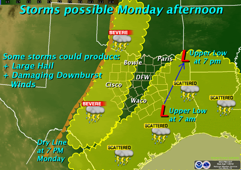
Two features will bring a chance of thunderstorms to North Texas Monday afternoon. Isolated to scattered showers and thunderstorms are expected across the southeastern third of North Texas as an upper level low moves across east Texas. Thunderstorms are also expected to develop along the dry line Monday afternoon. Some of these storms will have the potential to produce large hail and damaging downburst winds. This activity may work its way into the western areas late Monday afternoon and is expected to spread farther east into North Texas Monday night.
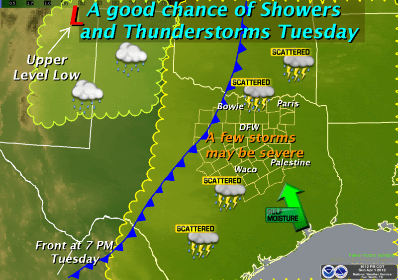
As a strong upper level low sits over northeastern New Mexico... abundant gulf moisture will continue to spread across North Texas. A cold front will move into the northwestern part of North Texas Tuesday afternoon. We will see a good chance of showers and thunderstorms Tuesday with the rain ending west of the I-35 corridor by midnight. A few severe storms are possible which would produce large hail and damaging winds as well as heavy rain and cloud to ground lightning.
Two features will bring a chance of thunderstorms to North Texas Monday afternoon. Isolated to scattered showers and thunderstorms are expected across the southeastern third of North Texas as an upper level low moves across east Texas. Thunderstorms are also expected to develop along the dry line Monday afternoon. Some of these storms will have the potential to produce large hail and damaging downburst winds. This activity may work its way into the western areas late Monday afternoon and is expected to spread farther east into North Texas Monday night.
As a strong upper level low sits over northeastern New Mexico... abundant gulf moisture will continue to spread across North Texas. A cold front will move into the northwestern part of North Texas Tuesday afternoon. We will see a good chance of showers and thunderstorms Tuesday with the rain ending west of the I-35 corridor by midnight. A few severe storms are possible which would produce large hail and damaging winds as well as heavy rain and cloud to ground lightning.
0 likes
The following post is NOT an official forecast and should not be used as such. It is just the opinion of the poster and may or may not be backed by sound meteorological data. It is NOT endorsed by any professional institution including storm2k.org For Official Information please refer to the NHC and NWS products.
-
Texas Snowman
- Storm2k Moderator
- Posts: 6197
- Joined: Fri Jan 25, 2008 11:29 am
- Location: Denison, Texas
Re: Texas Spring 2012
Interesting note in Fort Worth AFD about potential for severe weather tonight: potential for "baseball sized hail or larger."
Yup, that will get your attention!
------
000
FXUS64 KFWD 020912
AFDFWD
AREA FORECAST DISCUSSION
NATIONAL WEATHER SERVICE FORT WORTH TX
412 AM CDT MON APR 2 2012
.DISCUSSION...
DIFFICULT FORECAST TODAY WITH A COMPLEX SYNOPTIC PATTERN OVER
TEXAS THAT WILL BE RAPIDLY EVOLVING. THERE IS A MAJOR LONGWAVE
TROUGH APPROACHING FROM THE WEST AND A POTENT UPPER LEVEL LOW WILL
CLOSE OFF AT THE BASE OF THIS TROUGH OVER NEW MEXICO TODAY. THE
COMPLEXITY OF THE FORECAST IS DUE TO A WEAK UPPER LEVEL LOW THAT
IS CURRENTLY MOVING NORTH THROUGH SOUTHEAST TEXAS AND ALSO A MCS
THAT IS NOW TRACKING THROUGH SOUTH TEXAS. MODELS ARE HAVING A
DIFFICULT TIME WITH THE EVOLUTION OF THE MASS FIELDS DUE TO THE
TEXAS UPPER LOW AND ALSO HAVE NO CLUE THAT A MCS PUSHED THROUGH
SOUTH TEXAS OVERNIGHT. AS THE TEXAS LOW EJECTS N/NE INTO EAST
TEXAS TODAY...OUR 75KT EASTERLY 250MB WINDS ../WHICH IS HIGHLY
UNUSUAL FOR THIS TIME OF THE YEAR/.. WILL ABRUPTLY SWITCH BACK TO
THE WEST. MID LEVEL HEIGHT FIELDS WILL ALSO FLUCTUATE WILDLY. WITH
ALL OF THE ABRUPT CHANGES ALOFT...IT MAKES ME A BIT NERVOUS THAT
SOME UNFORESEEN VERTICAL MOTIONS WILL GREATLY IMPACT THE FORECAST.
IT LOOKS LIKE THE BRUNT OF THE DPVA ASSOCIATED WITH THE TEXAS
UPPER LOW WILL REMAIN EAST OF THE CWA TODAY...BUT SEVERAL OF THE
MODELS GENERATE CONVECTION OVER THE CENTRAL/EASTERN ZONES BY
MIDDAY. HOWEVER...THE SOUTH TEXAS MCS SHOULD CONTINUE TO TRACK
EASTWARD...PERHAPS EVEN CURLING NORTHEAST INTO LOUISIANA LATER
TODAY IF IT HOLDS TOGETHER. A MCS TRACKING THROUGH THIS AREA IS
NEVER FAVORABLE FOR CONVECTION IN NORTH TEXAS...AND THUS BELIEVE
THE MODELS THAT ARE PRODUCING CONVECTION BENEATH THE UPPER LOW
TODAY ARE OVERDONE. WILL CARRY 20-30 POPS IN THE SOUTHEAST ZONES
WHERE THEY MAY BE CLIPPED BY SOME ACTIVITY...BUT EXPECT MOST OF
IT TO BE EAST AND SOUTHEAST OF THE CWA.
ATTENTION WILL SHIFT TO THE WEST BY THIS AFTERNOON AS THE WESTERN
UPPER LOW CLOSES OFF AND INTENSIFIES OVER NEW MEXICO. A SURFACE
LOW SHOULD DEVELOP OVER THE PANHANDLE AND HELP TO KEEP THE DRY
LINE FROM MIXING TOO FAR EAST. EXPECT THE DRY LINE TO STALL JUST A
FEW MILES WEST OF OUR WESTERN CWA BORDER THIS AFTERNOON. FORCING
ASSOCIATED WITH THE NEW MEXICO UPPER LEVEL LOW SHOULD RESULT IN
LIFTING/EROSION OF THE CAP BY LATE AFTERNOON. AFTER A BOUT OF
MORNING CLOUDS...MOSTLY SUNNY SKIES THIS AFTERNOON SHOULD ALLOW
TEMPS TO WARM INTO THE MID 80S...AND VERY STEEP MID LEVEL LAPSE
RATES WILL BRING CAPE VALUES TO NEAR 3000 J/KG. WHILE INSTABILITY
IS MORE THAN SUFFICIENT FOR SEVERE WEATHER ALONE...THE BEST DEEP
LAYER SHEAR WILL LAG BACK TO THE WEST AND NOT ARRIVE UNTIL TONIGHT
WHEN A BELT OF STRONGER MID-UPPER LEVEL WESTERLIES ROUNDS THE BASE
OF THE LOW. WHILE THERE SHOULD BE JUST ENOUGH 0-6KM SHEAR TO ALLOW
FOR SUPERCELLS FIRING OFF THE DRY LINE LATE THIS AFTERNOON...THE
LIMITED FLOW ABOVE 500MB OF LESS THAN 30KT WILL HAVE IMPLICATIONS
ON SEVERE THREAT AND TYPE. SUPERCELLS WILL HAVE A DIFFICULT TIME
EVACUATING PRECIPITATION AWAY FROM THEIR UPDRAFT...WHICH WOULD
CERTAINLY FAVOR HP SUPERCELL STRUCTURES OR SMALL CLUSTERS...BUT
SHOULD TEND TO LIMIT THE TORNADO POTENTIAL. ON THE OTHER HAND...
FORECAST HODOGRAPHS ARE CLUSTERED RIGHT ON TOP OF EXPECTED STORM
MOTION AND MAY AID IN EFFICIENT RECYCLING OF HAIL IN THE UPDRAFT.
THIS COUPLED WITH THE STEEP LAPSE RATES AND HIGH CAPE CERTAINLY
POINTS TO A THREAT OF VERY LARGE HAIL...PERHAPS BASEBALL OR
LARGER. GIVEN THE WEAK FLOW ALOFT...STORM MOTIONS SHOULD REMAIN
LESS THAN 20KT AND CELLS WILL BE CAPABLE OF VERY HEAVY RAIN. THE
SLOW STORM MOTION WILL ALSO KEEP MOST OF THE ACTIVITY THIS EVENING
AND TONIGHT CONFINED TO THE WESTERN AND NORTHWESTERN CWA. WILL
SHOW POPS OF 50 PERCENT IN THE NW AND TAPER THEM DOWN TO 20 IN THE
SE. WE WILL ALSO STRESS THAT THE PRIMARY REGION FOR SEVERE WEATHER
IS IN THE NORTHWEST THIRD OF THE CWA THIS EVENING.
UPPER LEVEL LOW WILL LUMBER EASTWARD TUESDAY AND THE DRY LINE WILL
BEGIN TO HEAD EAST INTO THE CWA AS WELL. SYNOPTIC FORCING BY THIS
TIME SHOULD ERODE THE CAP OVER THE ENTIRE AREA...AND SCATTERED
CONVECTION SHOULD FIRE ALONG AND AHEAD OF THE DRY LINE AS EARLY AS
TUESDAY MORNING. WHILE SHEAR PROFILES INCREASE TUESDAY...THE LACK
OF A CAP MEANS STORMS WILL LIKELY DEVELOP WELL BEFORE PEAK HEATING
AND WILL COMPETE FOR MORE LIMITED INSTABILITY. CONVECTION SHOULD
CONTINUE THROUGH THE AFTERNOON AND EVENTUALLY LINE UP ALONG THE
DRY LINE/FRONT AND CLEAR THE AREA BY WEDNESDAY MORNING. THE BEST
CHANCES OF RAIN SHOULD OCCUR TUESDAY FOR MOST OF THE AREA...AND
THERE WILL BE A THREAT OF SEVERE WX WITH THIS ACTIVITY.
BEHIND THE FRONT...TEMPS WILL RETURN TO NEAR OR JUST SLIGHTLY
ABOVE NORMAL. DRIER AIR WILL PROMOTE CLEAR SKIES AND COMFORTABLE
HUMIDITY WEDNESDAY THROUGH FRIDAY. RETURN FLOW ORGANIZES BY FRIDAY
WITH THE MODERATING TREND CONTINUING INTO SATURDAY. NEXT UPPER
LEVEL SYSTEM WILL BRING A STALLING COLD FRONT TO OUR NW DOORSTEP
BY SUNDAY...AND WILL SHOW LOW CHANCES OF RAIN RETURNING.
TR.92
0 likes
The above post and any post by Texas Snowman is NOT an official forecast and should not be used as such. It is just the opinion of the poster and may or may not be backed by sound meteorological data. It is NOT endorsed by any professional institution including storm2k.org. For official information, please refer to NWS products.
-
Rgv20
- S2K Supporter
- Posts: 2466
- Age: 39
- Joined: Wed Jan 05, 2011 5:42 pm
- Location: Edinburg/McAllen Tx
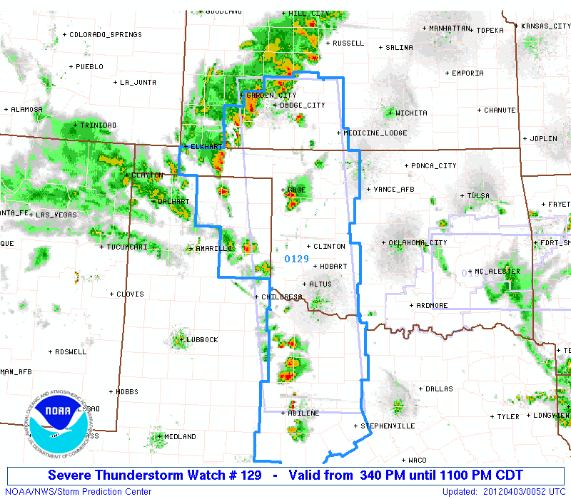
Parts of North Texas are in a Severe Thunderstorm Watch..
URGENT - IMMEDIATE BROADCAST REQUESTED
SEVERE THUNDERSTORM WATCH NUMBER 129
NWS STORM PREDICTION CENTER NORMAN OK
340 PM CDT MON APR 2 2012
THE NWS STORM PREDICTION CENTER HAS ISSUED A
SEVERE THUNDERSTORM WATCH FOR PORTIONS OF
SOUTHWEST KANSAS
WESTERN OKLAHOMA
NORTHWEST TEXAS INCLUDING THE EASTERN PANHANDLE
EFFECTIVE THIS MONDAY AFTERNOON AND EVENING FROM 340 PM UNTIL
1100 PM CDT.
HAIL TO 3 INCHES IN DIAMETER...THUNDERSTORM WIND GUSTS TO 70
MPH...AND DANGEROUS LIGHTNING ARE POSSIBLE IN THESE AREAS.
THE SEVERE THUNDERSTORM WATCH AREA IS APPROXIMATELY ALONG AND 60
STATUTE MILES EAST AND WEST OF A LINE FROM 35 MILES NORTH
NORTHEAST OF DODGE CITY KANSAS TO 60 MILES WEST SOUTHWEST OF
MINERAL WELLS TEXAS. FOR A COMPLETE DEPICTION OF THE WATCH SEE
THE ASSOCIATED WATCH OUTLINE UPDATE (WOUS64 KWNS WOU9).
REMEMBER...A SEVERE THUNDERSTORM WATCH MEANS CONDITIONS ARE
FAVORABLE FOR SEVERE THUNDERSTORMS IN AND CLOSE TO THE WATCH
AREA. PERSONS IN THESE AREAS SHOULD BE ON THE LOOKOUT FOR
THREATENING WEATHER CONDITIONS AND LISTEN FOR LATER STATEMENTS
AND POSSIBLE WARNINGS. SEVERE THUNDERSTORMS CAN AND OCCASIONALLY
DO PRODUCE TORNADOES.
OTHER WATCH INFORMATION...CONTINUE...WW 126...WW 127...WW 128...
DISCUSSION...TSTM DEVELOPMENT IS ANTICIPATED WITHIN THE NEXT HOUR OR
TWO ALONG STATIONARY FRONT OVER SWRN KS INTO THE NRN TX PNHDL...AS
WELL AS ALONG DRYLINE INTO W-CNTRL TX. AMBIENT AIR MASS HAS BECOME
STRONGLY UNSTABLE THIS AFTERNOON WITH MLCAPE APPROACHING 3000-3500
J/KG WHICH WILL SUPPORT INTENSE STORM DEVELOPMENT. AREA
VAD/PROFILER DATA AND MODEL FORECAST HODOGRAPHS INDICATE THAT
VERTICAL SHEAR /BOTH IN THE LOW LEVELS AND THROUGH A DEEP LAYER/ IS
MARGINALLY SUPPORTIVE OF SUPERCELLS. WHEN COUPLED WITH RATHER LARGE
TEMPERATURE-DEWPOINT SPREADS...THE EXPECTATION IS THAT VERY LARGE
HAIL AND DAMAGING WIND GUSTS WILL BE THE PRIMARY HAZARDS.
BY 03/00-03Z...BOTH LOW AND DEEP-LAYER SHEAR ARE FORECAST TO
STRENGTHEN...AND THE POTENTIAL FOR TORNADOES WILL INCREASE WITH
STORMS THAT REMAIN MORE DISCRETE. THUS...CONDITIONS WILL BE
MONITORED FOR A POSSIBLE UPGRADE TO A TORNADO WATCH LATER THIS
EVENING.
AVIATION...A FEW SEVERE THUNDERSTORMS WITH HAIL SURFACE AND ALOFT
TO 3 INCHES. EXTREME TURBULENCE AND SURFACE WIND GUSTS TO 60
KNOTS. A FEW CUMULONIMBI WITH MAXIMUM TOPS TO 500. MEAN STORM
MOTION VECTOR 20025.
...MEAD
0 likes
The following post is NOT an official forecast and should not be used as such. It is just the opinion of the poster and may or may not be backed by sound meteorological data. It is NOT endorsed by any professional institution including storm2k.org For Official Information please refer to the NHC and NWS products.
-
cycloneye

- Admin
- Posts: 149505
- Age: 69
- Joined: Thu Oct 10, 2002 10:54 am
- Location: San Juan, Puerto Rico
Re: Texas Spring 2012
I thought it was important to post the Tornado Watch for parts of Texas here.
Code: Select all
TORNADO WATCH OUTLINE UPDATE FOR WT 133
NWS STORM PREDICTION CENTER NORMAN OK
1210 PM CDT TUE APR 3 2012

TORNADO WATCH 133 IS IN EFFECT UNTIL 800 PM CDT FOR THE
 FOLLOWING LOCATIONS

TXC001-027-035-085-099-113-119-121-139-145-161-193-213-217-221-
223-231-251-257-281-289-293-309-331-349-367-379-395-397-425-439-
467-497-040100-
/O.NEW.KWNS.TO.A.0133.120403T1710Z-120404T0100Z/

TX
.    TEXAS COUNTIES INCLUDED ARE

ANDERSON             BELL                BOSQUE
COLLIN               CORYELL             DALLAS
DELTA                DENTON              ELLIS
FALLS                FREESTONE           HAMILTON
HENDERSON            HILL                HOOD
HOPKINS              HUNT                JOHNSON
KAUFMAN              LAMPASAS            LEON
LIMESTONE            MCLENNAN            MILAM
NAVARRO              PARKER              RAINS
ROBERTSON            ROCKWALL            SOMERVELL
TARRANT              VAN ZANDT           WISE
$$


ATTN...WFO...FWD...
0 likes
Visit the Caribbean-Central America Weather Thread where you can find at first post web cams,radars
and observations from Caribbean basin members Click Here
and observations from Caribbean basin members Click Here

Tornado on the ground heading for what I think are heavily populated areas (DFW metro):
TORNADO WARNING
TXC251-439-031830-
/O.NEW.KFWD.TO.W.0002.120403T1744Z-120403T1830Z/
BULLETIN - EAS ACTIVATION REQUESTED
TORNADO WARNING
NATIONAL WEATHER SERVICE FORT WORTH TX
1244 PM CDT TUE APR 3 2012
THE NATIONAL WEATHER SERVICE IN FORT WORTH HAS ISSUED A
* TORNADO WARNING FOR...
NORTHEASTERN JOHNSON COUNTY IN NORTH CENTRAL TEXAS...
SOUTHEASTERN TARRANT COUNTY IN NORTH CENTRAL TEXAS...
* UNTIL 130 PM CDT
* AT 1244 PM CDT...TRAINED STORM SPOTTERS OBSERVED A TORNADO NEAR
JOSHUA...MOVING NORTHEAST AT 25 MPH. IF YOU ARE IN THE PATH OF THIS
DANGEROUS STORM...TAKE COVER IMMEDIATELY!
* THE TORNADO WILL BE NEAR...
BURLESON AND BRIAROAKS AROUND 1255 PM CDT...
CROWLEY AROUND 100 PM CDT...
RENDON AROUND 110 PM CDT...
EVERMAN...EDGECLIFF AND MANSFIELD AROUND 115 PM CDT...
FOREST HILL AND KENNEDALE AROUND 120 PM CDT...
THIS WILL IMPACT THE FOLLOWING INTERSTATES...
I-35W BETWEEN MILE MARKERS 35 AND 59...
I-20 BETWEEN MILE MARKERS 426 AND 445...
I-30 BETWEEN MILE MARKERS 5 AND 23...
I-820 BETWEEN MILE MARKERS 1 AND 35.
PRECAUTIONARY/PREPAREDNESS ACTIONS...
EVACUATE MOBILE HOMES FOR A STORM SHELTER OR PERMANENT BUILDING. IF
NO SHELTER IS AVAILABLE...LIE FLAT IN THE NEAREST DITCH AND COVER
YOUR HEAD.
&&
LAT...LON 3278 9703 3257 9704 3255 9706 3255 9709
3252 9709 3239 9725 3243 9748 3286 9731
TIME...MOT...LOC 1744Z 205DEG 21KT 3246 9737
$$
CAVANAUGH
Two tor warnings now, both confirmed on the ground with a history of damage! Might be rain-wrapped and already baseball sized hail reported with the squall line!
EDIT: HOLY CRAP!!!!!!!!! Bad looking tornado on the ground near DWF!! Live streaming on CNN now!!
TORNADO WARNING
TXC251-439-031830-
/O.NEW.KFWD.TO.W.0002.120403T1744Z-120403T1830Z/
BULLETIN - EAS ACTIVATION REQUESTED
TORNADO WARNING
NATIONAL WEATHER SERVICE FORT WORTH TX
1244 PM CDT TUE APR 3 2012
THE NATIONAL WEATHER SERVICE IN FORT WORTH HAS ISSUED A
* TORNADO WARNING FOR...
NORTHEASTERN JOHNSON COUNTY IN NORTH CENTRAL TEXAS...
SOUTHEASTERN TARRANT COUNTY IN NORTH CENTRAL TEXAS...
* UNTIL 130 PM CDT
* AT 1244 PM CDT...TRAINED STORM SPOTTERS OBSERVED A TORNADO NEAR
JOSHUA...MOVING NORTHEAST AT 25 MPH. IF YOU ARE IN THE PATH OF THIS
DANGEROUS STORM...TAKE COVER IMMEDIATELY!
* THE TORNADO WILL BE NEAR...
BURLESON AND BRIAROAKS AROUND 1255 PM CDT...
CROWLEY AROUND 100 PM CDT...
RENDON AROUND 110 PM CDT...
EVERMAN...EDGECLIFF AND MANSFIELD AROUND 115 PM CDT...
FOREST HILL AND KENNEDALE AROUND 120 PM CDT...
THIS WILL IMPACT THE FOLLOWING INTERSTATES...
I-35W BETWEEN MILE MARKERS 35 AND 59...
I-20 BETWEEN MILE MARKERS 426 AND 445...
I-30 BETWEEN MILE MARKERS 5 AND 23...
I-820 BETWEEN MILE MARKERS 1 AND 35.
PRECAUTIONARY/PREPAREDNESS ACTIONS...
EVACUATE MOBILE HOMES FOR A STORM SHELTER OR PERMANENT BUILDING. IF
NO SHELTER IS AVAILABLE...LIE FLAT IN THE NEAREST DITCH AND COVER
YOUR HEAD.
&&
LAT...LON 3278 9703 3257 9704 3255 9706 3255 9709
3252 9709 3239 9725 3243 9748 3286 9731
TIME...MOT...LOC 1744Z 205DEG 21KT 3246 9737
$$
CAVANAUGH
Two tor warnings now, both confirmed on the ground with a history of damage! Might be rain-wrapped and already baseball sized hail reported with the squall line!
EDIT: HOLY CRAP!!!!!!!!! Bad looking tornado on the ground near DWF!! Live streaming on CNN now!!
0 likes
-
Extratropical94

- Professional-Met

- Posts: 3545
- Age: 31
- Joined: Wed Oct 20, 2010 6:36 am
- Location: Hamburg, Germany
- Contact:
Very strong wording in the warnings!
AT 116 PM CDT...NATIONAL WEATHER SERVICE METEOROLOGISTS CONFIRMED A
LARGE AND EXTREMELY DANGEROUS TORNADO. THIS TORNADO WAS LOCATED NEAR
LANCASTER...MOVING NORTH AT 20 MPH.
THIS IS A TORNADO EMERGENCY FOR SOUTHERN PORTIONS OF THE CITY OF
DALLAS AND THE CITY OF LANCASTER! SEEK SHELTER NOW!
THE TORNADO WILL BE NEAR...
LANCASTER AROUND 125 PM CDT...
PRECAUTIONARY/PREPAREDNESS ACTIONS...
A TORNADO HAS BEEN CONFIRMED! THIS IS AN EXTREMELY DANGEROUS AND LIFE
THREATENING SITUATION. IF YOU ARE IN THE PATH OF THIS DESTRUCTIVE
TORNADO...TAKE COVER IMMEDIATELY.
0 likes
54° 11' 59'' N, 9° 9' 20'' E
Boomer Sooner!
Go Broncos! Go Cards!
Clinching counties, one at a time: https://mob-rule.com/user-gifs/USA/xtrp94.gif
- Daniel
Boomer Sooner!
Go Broncos! Go Cards!
Clinching counties, one at a time: https://mob-rule.com/user-gifs/USA/xtrp94.gif
- Daniel
Re: Texas Spring 2012
TORNADO WARNING
TXC367-439-031900-
/O.NEW.KFWD.TO.W.0004.120403T1816Z-120403T1900Z/
BULLETIN - EAS ACTIVATION REQUESTED
TORNADO WARNING
NATIONAL WEATHER SERVICE FORT WORTH TX
116 PM CDT TUE APR 3 2012
THE NATIONAL WEATHER SERVICE IN FORT WORTH HAS ISSUED A
* TORNADO WARNING FOR...
NORTHEASTERN PARKER COUNTY IN NORTH CENTRAL TEXAS...
NORTHWESTERN TARRANT COUNTY IN NORTH CENTRAL TEXAS...
* UNTIL 200 PM CDT
* AT 115 PM CDT...NATIONAL WEATHER SERVICE METEOROLOGISTS DETECTED A
SEVERE THUNDERSTORM CAPABLE OF PRODUCING A TORNADO 3 MILES NORTH OF
WILLOW PARK...MOVING NORTHEAST AT 25 MPH.
* THE TORNADO WILL BE NEAR...
SANCTUARY AND LAKESIDE AROUND 130 PM CDT...
AZLE AND RENO AROUND 135 PM CDT...
PELICAN BAY AND BRIAR AROUND 140 PM CDT...
EAGLE MOUNTAIN AND SAGINAW AROUND 145 PM CDT...
PECAN ACRES AND NEWARK AROUND 150 PM CDT...
PRECAUTIONARY/PREPAREDNESS ACTIONS...
EVACUATE MOBILE HOMES FOR A STORM SHELTER OR PERMANENT BUILDING. IF
NO SHELTER IS AVAILABLE...LIE FLAT IN THE NEAREST DITCH AND COVER
YOUR HEAD.
&&
LAT...LON 3299 9744 3299 9730 3286 9731 3273 9769
3288 9772 3300 9758 3300 9744
TIME...MOT...LOC 1815Z 228DEG 23KT 3281 9764
$$
CAVANAUGH
3 tornado warnings now.
0 likes
-
Extratropical94
- Professional-Met
- Posts: 3545
- Age: 31
- Joined: Wed Oct 20, 2010 6:36 am
- Location: Hamburg, Germany
- Contact:
Excerpt from SPC's MD 430:
[...]THOUGH IN GENERAL EXPECT ANY SINGLE TORNADO TO BE RELATIVELY BRIEF AS STORMS MOVE QUICKLY NEWD
ACROSS THE BOUNDARY...THE ENHANCED POTENTIAL ACROSS THE METROPLEX AREA ITSELF SUGGESTS CONTINUED/HEIGHTENED RISK FOR A DAMAGING EVENT.
Seems like the DFW area is in the crosshairs.
[...]THOUGH IN GENERAL EXPECT ANY SINGLE TORNADO TO BE RELATIVELY BRIEF AS STORMS MOVE QUICKLY NEWD
ACROSS THE BOUNDARY...THE ENHANCED POTENTIAL ACROSS THE METROPLEX AREA ITSELF SUGGESTS CONTINUED/HEIGHTENED RISK FOR A DAMAGING EVENT.
Seems like the DFW area is in the crosshairs.
0 likes
54° 11' 59'' N, 9° 9' 20'' E
Boomer Sooner!
Go Broncos! Go Cards!
Clinching counties, one at a time: https://mob-rule.com/user-gifs/USA/xtrp94.gif
- Daniel
Boomer Sooner!
Go Broncos! Go Cards!
Clinching counties, one at a time: https://mob-rule.com/user-gifs/USA/xtrp94.gif
- Daniel
Re: Texas Spring 2012
I'm watching WFAA live footage very carefully. You can see some very LARGE debris being thrown about. Very scary. Hoping this thing avoids me.
 Someone on Twitter screencapped this from the live feed.
Someone on Twitter screencapped this from the live feed.
0 likes
-
cheezyWXguy

- Category 5

- Posts: 6282
- Joined: Mon Feb 13, 2006 12:29 am
- Location: Dallas, TX

Re: Texas Spring 2012
The eastern cell: 2:03p A tornado is reported on the ground near Mesquite Rodeo Stadium area. (per WFAA)
The center cell: 2:08p Possible tornado is approaching the south side of the D/FW Airport near the REMOTE SOUTH PARKING area moving NE at 25 mph. (per WFAA)
The western cell: Moving into Denton, is tornado warned. I haven't seen any confirmed touchdown from it yet. Only that radar indicated it's capable of producing a tornado. (Per NWS)
There's so much going on its hard to keep up with all of them. Hope this info helps.
0 likes
-
Extratropical94
- Professional-Met
- Posts: 3545
- Age: 31
- Joined: Wed Oct 20, 2010 6:36 am
- Location: Hamburg, Germany
- Contact:
Plano might be lucky this time, coz at the moment it's located in the mile-wide line between the two tornado warnings.
That doesn't mean you or your parents are in a safe area tonight.
Edit: Depends of course in which part of Plano your parents are, the more south and east, the safer they are.
That doesn't mean you or your parents are in a safe area tonight.
Edit: Depends of course in which part of Plano your parents are, the more south and east, the safer they are.
Last edited by Extratropical94 on Tue Apr 03, 2012 2:30 pm, edited 1 time in total.
0 likes
54° 11' 59'' N, 9° 9' 20'' E
Boomer Sooner!
Go Broncos! Go Cards!
Clinching counties, one at a time: https://mob-rule.com/user-gifs/USA/xtrp94.gif
- Daniel
Boomer Sooner!
Go Broncos! Go Cards!
Clinching counties, one at a time: https://mob-rule.com/user-gifs/USA/xtrp94.gif
- Daniel