Texas Spring 2012
Moderator: S2k Moderators
Forum rules

The posts in this forum are NOT official forecast and should not be used as such. They are just the opinion of the poster and may or may not be backed by sound meteorological data. They are NOT endorsed by any professional institution or STORM2K.
-
cycloneye

- Admin

- Posts: 149505
- Age: 69
- Joined: Thu Oct 10, 2002 10:54 am
- Location: San Juan, Puerto Rico
Re: Texas Spring 2012
Just heard on CNN that 400 flights were cancelled at Dallas/Ft Worth airport.Many planes were damaged by hail.
0 likes
Visit the Caribbean-Central America Weather Thread where you can find at first post web cams,radars
and observations from Caribbean basin members Click Here
and observations from Caribbean basin members Click Here
-
Stephanie

- S2K Supporter

- Posts: 23843
- Age: 63
- Joined: Thu Feb 06, 2003 9:53 am
- Location: Glassboro, NJ
Re: Texas Spring 2012
somethingfunny wrote:I chased the storms today, never left the eastern half of Dallas County. I've never seen a tornado in my life and have lived in DFW for 11 years. Today I saw three of them.
I'm not a good photographer when I'm driving.
Near Loop12 and I-30 in East Dallas, the funnel is too freaking close to me. In the foreground, behind the stupid Shell gasoline makes your engine better sign. It wasn't on the ground at this point.
In east Mesquite driving east, came around a bend and saw this:
Zoomed in, it was a monster. Was only on the ground for a few minutes, in Forney.
I also saw the tornado from I-20 near I-45. I SAW that thing and it was terrifying. And gray against a gray sky and I don't think any of my photos came out with anything identifiable.


Great pictures. That last was was creepy. It took out an elementary school in Forney, right? I hope there were no serious injuries. During lunch I went on the internet and there was a breaking news banner on MSN.com about the tornadoes down there.
0 likes
-
Rgv20

- S2K Supporter
- Posts: 2466
- Age: 39
- Joined: Wed Jan 05, 2011 5:42 pm
- Location: Edinburg/McAllen Tx
A chance of severe storms for parts of south and east Texas.
Severe Thunderstorm Watch
SEVERE THUNDERSTORM WATCH OUTLINE UPDATE FOR WS 139
NWS STORM PREDICTION CENTER NORMAN OK
1255 PM CDT WED APR 4 2012
SEVERE THUNDERSTORM WATCH 139 IS IN EFFECT UNTIL 800 PM CDT
FOR THE FOLLOWING LOCATIONS
TXC007-025-039-047-057-061-131-157-167-175-215-239-247-249-261-
273-297-321-355-391-409-427-469-481-489-050100-
/O.NEW.KWNS.SV.A.0139.120404T1755Z-120405T0100Z/
TX
. TEXAS COUNTIES INCLUDED ARE
ARANSAS BEE BRAZORIA
BROOKS CALHOUN CAMERON
DUVAL FORT BEND GALVESTON
GOLIAD HIDALGO JACKSON
JIM HOGG JIM WELLS KENEDY
KLEBERG LIVE OAK MATAGORDA
NUECES REFUGIO SAN PATRICIO
STARR VICTORIA WHARTON
WILLACY
$$
0 likes
The following post is NOT an official forecast and should not be used as such. It is just the opinion of the poster and may or may not be backed by sound meteorological data. It is NOT endorsed by any professional institution including storm2k.org For Official Information please refer to the NHC and NWS products.


Alright survey damage shows a series of locally damaging ef0 to ef3 along the I-30 corridor mostly for eastplexers. It was an average April style tornado frenzy for Texas from an outside point of view (not so much if you lost property). The fact that it happened in an area so heavily watched we got neat footage (aren't tornadoes that happen in the metroplex photogenic anyway?).
That tracter trailer video will probably now be forever painted in tornado lore and studied a million times over. If an ef2 can do that hopefully it gets people's attention in the future about bigger ones.
That tracter trailer video will probably now be forever painted in tornado lore and studied a million times over. If an ef2 can do that hopefully it gets people's attention in the future about bigger ones.
0 likes
The above post and any post by Ntxw is NOT an official forecast and should not be used as such. It is just the opinion of the poster and may or may not be backed by sound meteorological data. It is NOT endorsed by any professional institution including Storm2k. For official information, please refer to NWS products.
Help support Storm2K!
-
somethingfunny

- ChatStaff

- Posts: 3926
- Age: 37
- Joined: Thu May 31, 2007 10:30 pm
- Location: McKinney, Texas
Here's what you really need to know about that tractor trailer video: They're just big empty mobile homes. Don't stay in your mobile home if a tornado of any strength is coming.
0 likes
I am not a meteorologist, and any posts made by me are not official forecasts or to be interpreted as being intelligent. These posts are just my opinions and are probably silly opinions.

-
somethingfunny
- ChatStaff
- Posts: 3926
- Age: 37
- Joined: Thu May 31, 2007 10:30 pm
- Location: McKinney, Texas
Re: Texas Spring 2012
Everybody north of a line from Lubbock to Shreveport is included in a Day3 Slight Risk on the SPC outlook.
Regarding the section I bolded.... I swear I've read that exact wording before. I'm not sure though, because I stopped reading it halfway through when a tornado was broadcast live on WFAA. Hopefully they're just being cautious now.
There's also a very rare Day SIX threat outlined from the Red River north into Kansas.
DAY 3 CONVECTIVE OUTLOOK
NWS STORM PREDICTION CENTER NORMAN OK
0230 AM CDT SAT APR 07 2012
VALID 091200Z - 101200Z
...THERE IS A SLGT RISK OF SVR TSTMS ACROSS PART OF THE SRN PLAINS
TO THE ARKLATEX REGION...
...SYNOPSIS...
A BLOCKING PATTERN WILL PERSIST OVER NORTH AMERICA ON MONDAY AS AN
UPPER RIDGE SHARPENS OVER THE FULL EXTENT OF THE ROCKIES BETWEEN A
DEEP LONGWAVE TROUGH LOCATED ALONG AND OFF THE WEST COAST...AND A
LONGWAVE TROUGH PERSISTING EAST OF THE ROCKIES.
AT THE SURFACE...THE TRAILING PORTION OF A FRONT ATTENDANT TO A FAST
MOVING SHORTWAVE TROUGH TRANSLATING THROUGH THE GREAT LAKES AND NERN
STATES ON DAY 2/SUNDAY IS EXPECTED TO EXTEND WSWWD FROM THE MID MS
VALLEY INTO SRN KS BY THE START OF DAY 3/MONDAY. GIVEN A NWLY FLOW
REGIME BECOMING BETTER ESTABLISHED ACROSS THE PLAINS STATES...THIS
SURFACE BOUNDARY IS EXPECTED TO SETTLE SLOWLY SWD THROUGH OK AND THE
TX PANHANDLE...WHILE THE ERN EXTENT REACHES THE MID SOUTH TO SRN
APPALACHIANS BY 12Z TUESDAY.
...SRN PLAINS TO THE ARKLATEX...
LOW LEVEL FLOW IS EXPECTED TO BECOME BETTER ESTABLISHED ACROSS THE
SRN PLAINS ON MONDAY. THIS WILL SUPPORT BOTH MOISTURE RETURN AND
LOW LEVEL WAA BENEATH A PLUME OF STEEP MIDLEVEL LAPSE RATES /AROUND
7.5-8.0 C PER KM/ EXTENDING ESEWD ACROSS THE TX/OK PANHANDLES INTO
OK...RESULTING IN MODERATE INSTABILITY. DESPITE THE LACK OF STRONG
FORCING ALOFT...MODELS AGREE THAT A WEAK IMPULSE SHOULD TRACK SEWD
INTO OK BY PEAK HEATING. THIS COMBINED WITH LOW LEVEL WAA AND
SURFACE HEATING WEAKENING INHIBITION THROUGH THE DAY WILL SUPPORT
TSTM DEVELOPMENT MONDAY AFTERNOON INVOF THE SWD MOVING FRONT.
STRENGTHENING BULK SHEAR THROUGH THE DAY /40-50 KT/ WILL RESULT IN
ORGANIZED STORMS...WITH VERTICALLY VEERING WIND PROFILES SUPPORTING
ROTATING UPDRAFTS AND THE POTENTIAL FOR HAIL AND STRONG WIND GUSTS.
A TORNADO THREAT CANNOT BE RULED OUT...GIVEN LOW LEVEL HODOGRAPH
CURVATURE. MODELS SUGGEST CONTINUED LOW LEVEL WAA INTO MONDAY
EVENING/OVERNIGHT SHOULD SUPPORT A CONTINUE THREAT FOR TSTMS AND
SOME SEVERE AFTER DARK WITH THE FORMATION OF ONE OR MORE MCSS.
..PETERS.. 04/07/2012
Regarding the section I bolded.... I swear I've read that exact wording before. I'm not sure though, because I stopped reading it halfway through when a tornado was broadcast live on WFAA. Hopefully they're just being cautious now.
There's also a very rare Day SIX threat outlined from the Red River north into Kansas.
0 likes
I am not a meteorologist, and any posts made by me are not official forecasts or to be interpreted as being intelligent. These posts are just my opinions and are probably silly opinions.
Re: Texas Spring 2012
I don't think cape values will support the same kind of thunderstorms this go round early this week/tonight. Maybe in NW Texas, the next big system looks interesting though.
0 likes
The above post and any post by Ntxw is NOT an official forecast and should not be used as such. It is just the opinion of the poster and may or may not be backed by sound meteorological data. It is NOT endorsed by any professional institution including Storm2k. For official information, please refer to NWS products.
Help support Storm2K!
Help support Storm2K!

Re: Texas Spring 2012
There are two TOR warnings right now with a confirmed tornado 5 miles west of Highway 163, moving into Sterling County TX.
Is this the same system that could happen on Friday the 13th?
Ntxw wrote:Maybe in NW Texas, the next big system looks interesting though.
There's also a very rare Day SIX threat outlined from the Red River north into Kansas.
Is this the same system that could happen on Friday the 13th?
0 likes
-
weatherdude1108
- Category 5

- Posts: 4228
- Joined: Tue Dec 13, 2011 1:04 pm
- Location: Northwest Austin/Cedar Park, TX
I guess starting this Wednesday may be the catalyst or transition day from the current Central and southern Texas weather doldrums according to the latest discussion.
000
FXUS64 KEWX 090854
AFDEWX
AREA FORECAST DISCUSSION
NATIONAL WEATHER SERVICE AUSTIN/SAN ANTONIO TX
354 AM CDT MON APR 9 2012
.DISCUSSION...
WEATHER PATTERNS THIS WEEK THROUGH WEDNESDAY INITIALLY SHOW S/W
ENERGY FROM THE SW U.S. AND NORTHERN MEXICO MOVING EAST AND
DEAMPLIFYING IN THE WEAK RIDGE ALOFT OVER SOUTH CENTRAL TEXAS.
FOR TODAY S/W ENERGY ACROSS WEST TEXAS EARLY THIS MORNING WILL MOVE
TO JUST NORTH TO NORTHEAST OF SOUTH CENTRAL TEXAS THIS EVENING AND
EAST OF THE AREA TUESDAY. WILL SHOW A SLIGHT CHANCE OF SHOWERS OR
THUNDERSTORMS FOR THE LATE AFTERNOON OVER THE WEST PART OF THE AREA
AND OVER THE WEST TO NORTHERN EDGE OF SOUTH CENTRAL TEXAS THIS
EVENING. FOR TUESDAY WILL SHOW A SLIGHT CHANCE OF SHOWERS OR
THUNDERSTORMS OVER THE WEST PART OF SOUTH CENTRAL TEXAS NEAR
VAL VERDE AND EDWARDS COUNTIES...WHERE DRY LINE ACTIVITY AND THE
S/W TROF MOVING NW OF THE AREA MAY CAUSE LATE AFTERNOON AND EVENING
SHOWERS AGAIN.
ON WEDNESDAY THE DAY IS EXPECTED TO BEGIN WITH STABLE CONDITIONS
THAT CHANGE TO MORE UNSTABLE CONDITIONS WEDNESDAY NIGHT THROUGH
THURSDAY...AS THE RIDGE ALOFT WEAKENS...AND A LOW AMPLITUDE 500 HPA
TROF MOVES FROM THE ROCKIES TO THE CENTRAL U.S. THIS SHOWS AN
INCREASING CHANCE OF SHOWERS OR THUNDERSTORMS FROM THE WEST LATE
WEDNESDAY THROUGH WEDNESDAY NIGHT. CONTINUED WITH A SLIGHT CHANCE
OF SHOWERS OR THUNDERSTORMS THURSDAY. ON FRIDAY...THE HEIGHT FIELD
ALOFT IS FORECAST TO CONTINUE TO WEAKEN...OPENING THE DOOR FOR
ADDITIONAL S/W ENERGY TO PASS NEAR THE AREA IN SW WINDS ALOFT.
THE PATTERN FOR SATURDAY AND SUNDAY SHOWS THE RIDGE EAST OF
SOUTH CENTRAL TEXAS...AS ANOTHER DEVELOPING LOW FORMS ACROSS THE
SW U.S. AND NORTHERN MEXICO. A SERIES OF S/W TROFS ARE FORECAST
TO MOVE EAST OF THE LOW OVER THE SW U.S. AND NORTHERN MEXICO...
MAINLY NW OF SOUTH CENTRAL TEXAS FOR THE WEEKEND. WILL SHOW A
SLIGHT CHANCE OF SHOWERS FOR SATURDAY...AND THEN INCREASE THE
CHANCE OF SHOWERS SLIGHTLY ON SUNDAY. BY SUNDAY NIGHT AND
MONDAY...THE ECMWF AND GFS BOTH SHOW A RAIN MAKING WEATHER SYSTEM
COMING ACROSS SOUTH CENTRAL TEXAS FROM THE WEST...BRINGING A
CHANCE OF SHOWERS OR THUNDERSTORMS. RAIN CHANCES COULD CONTINUE TO
TUESDAY OF NEXT WEEK...AS THE LOW MOVES NORTH OF SOUTH CENTRAL
TEXAS...MAINTAINING THE TRENDS THAT HAVE BEEN IN PLACE SINCE
MARCH.
0 likes
The preceding post is NOT an official forecast, and should not be used as such. It is only the opinion of the poster and may or may not be backed by sound meteorological data. It is NOT endorsed by any professional institution including storm2k.org. For Official Information please refer to the NHC and NWS products.
-
Rgv20
- S2K Supporter
- Posts: 2466
- Age: 39
- Joined: Wed Jan 05, 2011 5:42 pm
- Location: Edinburg/McAllen Tx
Took a quick look at the the CFSv2 long range forecast and it is encouraging for the state of Texas as is forecasting above normal rainfall for most of the state by late April and the month of May 
Forecast valid for April 17 thru the 23
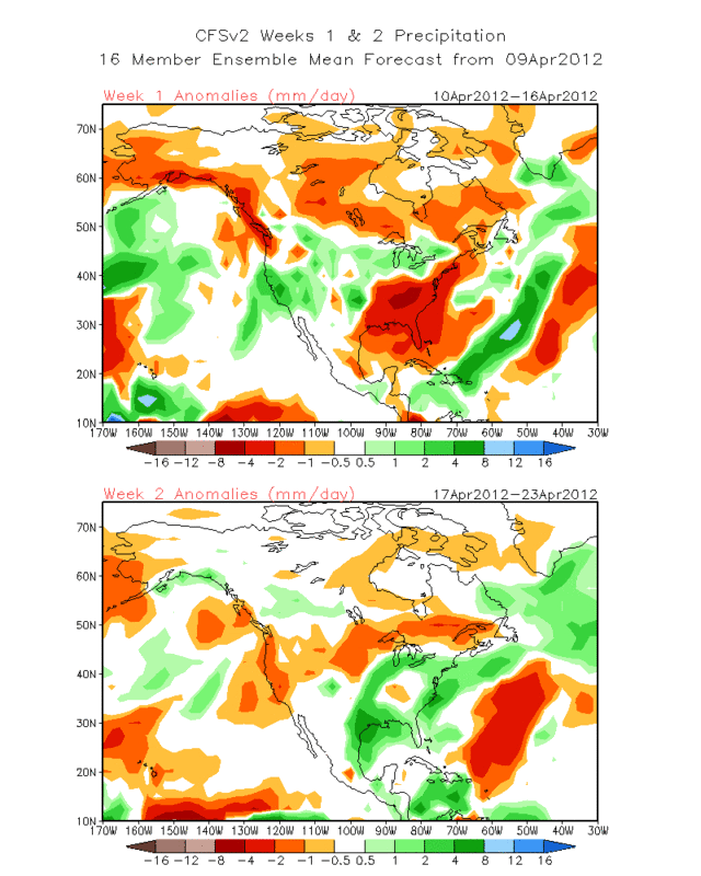
Forecast valid for May
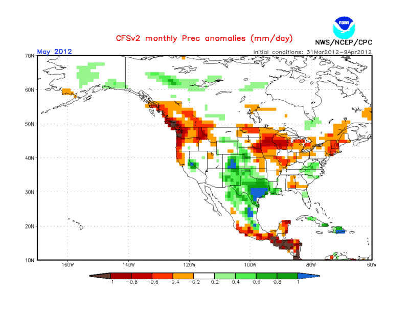
I'm loving those blue colors as they mean above normal rainfall!
Forecast valid for April 17 thru the 23
Forecast valid for May
I'm loving those blue colors as they mean above normal rainfall!
0 likes
The following post is NOT an official forecast and should not be used as such. It is just the opinion of the poster and may or may not be backed by sound meteorological data. It is NOT endorsed by any professional institution including storm2k.org For Official Information please refer to the NHC and NWS products.
-
weatherdude1108
- Category 5
- Posts: 4228
- Joined: Tue Dec 13, 2011 1:04 pm
- Location: Northwest Austin/Cedar Park, TX
Re:
Rgv20 wrote:Took a quick look at the the CFSv2 long range forecast and it is encouraging for the state of Texas as is forecasting above normal rainfall for most of the state by late April and the month of May
Forecast valid for April 17 thru the 23
Forecast valid for May
I'm loving those blue colors as they mean above normal rainfall!
Bring it!!
0 likes
-
weatherdude1108
- Category 5
- Posts: 4228
- Joined: Tue Dec 13, 2011 1:04 pm
- Location: Northwest Austin/Cedar Park, TX
I'm following a storm chaser from Lubbock who contracts for one of their local tv stations (not sure if allowed to name names, so I won't). His last post on FB (as of this post) around 11am on April 12th:
"While we've had some gentleman's chasing in Northwest Texas the last 3 days, things are about to ramp up in the Severe Weather Department for the next 3 days! (Wow, chasing 6 days in a row!!) KS and OK in particular will be increasingly under the gun through Saturday, was well as North Central TX. Do you have your weather radio? Is it on? Friday and especially Saturday could be a tornado outbreak. I think NW TX,for the most part, is finally going to get a break from the Severe Weather."
"While we've had some gentleman's chasing in Northwest Texas the last 3 days, things are about to ramp up in the Severe Weather Department for the next 3 days! (Wow, chasing 6 days in a row!!) KS and OK in particular will be increasingly under the gun through Saturday, was well as North Central TX. Do you have your weather radio? Is it on? Friday and especially Saturday could be a tornado outbreak. I think NW TX,for the most part, is finally going to get a break from the Severe Weather."
0 likes
The preceding post is NOT an official forecast, and should not be used as such. It is only the opinion of the poster and may or may not be backed by sound meteorological data. It is NOT endorsed by any professional institution including storm2k.org. For Official Information please refer to the NHC and NWS products.
-
Rgv20
- S2K Supporter
- Posts: 2466
- Age: 39
- Joined: Wed Jan 05, 2011 5:42 pm
- Location: Edinburg/McAllen Tx
Some impressive Tstroms just west of my area...already can hear and see the lighting..
0 likes
The following post is NOT an official forecast and should not be used as such. It is just the opinion of the poster and may or may not be backed by sound meteorological data. It is NOT endorsed by any professional institution including storm2k.org For Official Information please refer to the NHC and NWS products.
-
cctxhurricanewatcher

- Category 5
- Posts: 1206
- Joined: Sun Sep 12, 2004 8:53 pm
- Location: Corpus Christi, Texas
Re: Texas Spring 2012
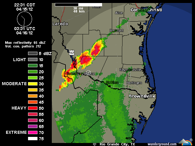
Rough day so far in the Coastal Bend. Some areas have received up to 10-16 inches of rain since midnight. I actually heard Portland got 10 inches within four hours. I myself have at 4 1/2 since 8AM in far northwest Corpus Chrsiti. I think we can post a "Drought Cancel", or atleast a Drought on hold.
PRELIMINARY LOCAL STORM REPORT...CORRECTED
NATIONAL WEATHER SERVICE CORPUS CHRISTI TX
1244 PM CDT MON APR 16 2012
..TIME... ...EVENT... ...CITY LOCATION... ...LAT.LON...
..DATE... ....MAG.... ..COUNTY LOCATION..ST.. ...SOURCE....
..REMARKS..
0539 AM TORNADO 1 N PORTLAND 27.89N 97.33W
04/16/2012 SAN PATRICIO TX LAW ENFORCEMENT
DAMAGE TO HOMES ON THE NORTH SIDE OF PORTLAND. FENCES AND
TREE LIMBS DOWN.
0544 AM FLASH FLOOD 4 SE WOODSBORO 28.20N 97.28W
04/16/2012 REFUGIO TX LAW ENFORCEMENT
WATER OVER THE ROAD ON FM 1360 AND ARANSAS RIVER ROAD
BETWEEN WOODSBORO AND BAYVIEW.
0544 AM TORNADO GREGORY 27.92N 97.29W
04/16/2012 SAN PATRICIO TX LAW ENFORCEMENT
DAMAGE TO COTTON GIN NEAR GREGORY ALONG WITH POWERLINES
DOWN.
0720 AM FLASH FLOOD GREGORY 27.92N 97.29W
04/16/2012 SAN PATRICIO TX NWS EMPLOYEE
CARS UNDER WATER IN GREGORY NEAR HIGHWAY 35.
0725 AM HAIL 13 WNW LOMA ALTA 28.16N 98.71W
04/16/2012 E0.50 INCH MCMULLEN TX PUBLIC
REPORTED NEAR FARM TO MARKET ROAD 624.
0755 AM FLASH FLOOD PORTLAND 27.88N 97.33W
04/16/2012 SAN PATRICIO TX PUBLIC
MAJOR STREET FLOODING OCCURRING IN CITY.
0815 AM FLASH FLOOD PORTLAND 27.88N 97.33W
04/16/2012 SAN PATRICIO TX NEWSPAPER
MOORE AVENUE UNPASSABLE BETWEEN 7 AND 815AM DUE TO WATER
ON ROAD.
0825 AM FLASH FLOOD GREGORY 27.92N 97.29W
04/16/2012 SAN PATRICIO TX NWS EMPLOYEE
VEHICLES BECOMING STRANDED IN FLOODED ROADWAYS.
0935 AM FUNNEL CLOUD 5 E KINGSVILLE 27.51N 97.78W
04/16/2012 KLEBERG TX TRAINED SPOTTER
FUNNEL CLOUD MAY HAVE BRIEFLY TOUCHED DOWN OVER OPEN
PASTURE.
0947 AM FUNNEL CLOUD PORTLAND 27.88N 97.33W
04/16/2012 SAN PATRICIO TX PUBLIC
0947 AM FLASH FLOOD 3 NNE ROBSTOWN 27.84N 97.64W
04/16/2012 NUECES TX TRAINED SPOTTER
STREET FLOODING AT HWY 77 AND LEOPARD ST.
1023 AM TSTM WND GST 7 S BAYSIDE 27.97N 97.24W
04/16/2012 E60.00 MPH SAN PATRICIO TX EMERGENCY MNGR
ALSO PEA SIZE HAIL.
1023 AM FLASH FLOOD 7 S BAYSIDE 27.97N 97.24W
04/16/2012 SAN PATRICIO TX EMERGENCY MNGR
MORE THAN 15 INCHES OF STORM TOTAL RAINFALL.
1033 AM FLASH FLOOD GREGORY 27.92N 97.29W
04/16/2012 SAN PATRICIO TX DEPT OF HIGHWAYS
SPUR 202 AND FM 3284 ARE FLOODED.
1033 AM FLASH FLOOD CORPUS CHRISTI 27.71N 97.29W
04/16/2012 NUECES TX DEPT OF HIGHWAYS
NUMEROUS ROADS AND INTERSECTIONS FLOODED... I37 UNDER US
181...TURNAROUND NEAR NUECES CAUSWAY...MANY OTHERS.
1033 AM FLASH FLOOD 3 NW ROBSTOWN 27.83N 97.70W
04/16/2012 NUECES TX DEPT OF HIGHWAYS
INTERSECTION OF FM 624 AND US 77 CLOSED IN CALALLEN.
1033 AM FLASH FLOOD PORTLAND 27.88N 97.33W
04/16/2012 SAN PATRICIO TX DEPT OF HIGHWAYS
NUMEROUS ROADS FLOODED IN THE AREA...INCLUDING FM 893 AT
MEMORIAL PARKWAY.
1154 AM HEAVY RAIN 3 NE ROBSTOWN 27.83N 97.63W
04/16/2012 M6.25 INCH NUECES TX TRAINED SPOTTER
RAINFALL TOTAL SINCE 745 AM NEAR VIOLET AND LEOPARD IN
CALALLEN AREA.
1211 PM HAIL 7 SSE CC NAS 27.60N 97.22W
04/16/2012 E1.25 INCH NUECES TX PUBLIC
HAIL BROKE FLOOD LIGHTS AT THE ISLAND ITALIAN RESTAURANT
ON NORTH PADRE ISLAND
1217 PM MARINE TSTM WIND 9 SSE CC NAS 27.58N 97.22W
04/16/2012 M55.00 MPH GMZ250 TX MESONET
55 MPH WIND GUST /48 KTS/ MEASURED AT BOB HALL PIER.
1227 PM HAIL 8 SE CC NAS 27.60N 97.21W
04/16/2012 M1.50 INCH NUECES TX PUBLIC
FELL ON THE BEACH AT THE HOLIDAY INN ON NORTH PADRE
ISLAND
0 likes

Re:
Rgv20 wrote:Some impressive Tstroms just west of my area...already can hear and see the lighting..
Interesting to notice more severe thunderstorms in South Texas than here in Southeast Texas despite the fact that they are closer to the Mexican desert than we are. I wonder about it.
0 likes
Re: Texas Spring 2012
cctxhurricanewatcher wrote:Rough day so far in the Coastal Bend. Some areas have received up to 10-16 inches of rain since midnight. I actually heard Portland got 10 inches within four hours. I myself have at 4 1/2 since 8AM in far northwest Corpus Chrsiti. I think we can post a "Drought Cancel", or atleast a Drought on hold.
South Texas is still in a severe drought.
0 likes
-
somethingfunny
- ChatStaff
- Posts: 3926
- Age: 37
- Joined: Thu May 31, 2007 10:30 pm
- Location: McKinney, Texas
Re: Texas Spring 2012
Ptarmigan wrote:cctxhurricanewatcher wrote:Rough day so far in the Coastal Bend. Some areas have received up to 10-16 inches of rain since midnight. I actually heard Portland got 10 inches within four hours. I myself have at 4 1/2 since 8AM in far northwest Corpus Chrsiti. I think we can post a "Drought Cancel", or atleast a Drought on hold.
South Texas is still in a severe drought.
It's the only way droughts end in this state.

Next update will contain data as of tomorrow morning, and will be released Thursday morning.
0 likes
I am not a meteorologist, and any posts made by me are not official forecasts or to be interpreted as being intelligent. These posts are just my opinions and are probably silly opinions.
-
cycloneye
- Admin
- Posts: 149505
- Age: 69
- Joined: Thu Oct 10, 2002 10:54 am
- Location: San Juan, Puerto Rico
Re: Texas Spring 2012
These are only a couple of flood advisories that are up in South Texas. Hopefully,the drought aliviates with this kind of rainfall,but without any bad news of casualties.
FLOOD ADVISORY
NATIONAL WEATHER SERVICE HOUSTON/GALVESTON TX
228 PM CDT MON APR 16 2012
TXC039-167-321-162230-
/O.NEW.KHGX.FA.Y.0047.120416T1928Z-120416T2230Z/
/00000.N.ER.000000T0000Z.000000T0000Z.000000T0000Z.OO/
GALVESTON TX-BRAZORIA TX-MATAGORDA TX-
228 PM CDT MON APR 16 2012
THE NATIONAL WEATHER SERVICE IN LEAGUE CITY HAS ISSUED A
* URBAN AND SMALL STREAM FLOOD ADVISORY FOR...
GALVESTON COUNTY IN SOUTHEASTERN TEXAS...
BRAZORIA COUNTY IN SOUTHEASTERN TEXAS...
EXTREME EAST CENTRAL MATAGORDA COUNTY IN SOUTHEASTERN TEXAS...
* UNTIL 530 PM CDT
* AT 219 PM CDT...DOPPLER RADAR INDICATED HEAVY RAIN DUE TO
THUNDERSTORMS. THIS WILL CAUSE URBAN AND SMALL STREAM FLOODING IN
THE ADVISORY AREA. 4 TO 5 INCHES WITH ISOLATED AMOUNTS OF UP TO 9
INCHES HAS FALLEN ACROSS PORTIONS OF THE AREA FROM BRAZORIA TO
JUST SOUTH OF ANGLETON AND DANBURY TO NEAR SANTA FE OVERNIGHT AND
THIS MORNING. THIS CLUSTER OF STORMS MOVING THROUGH THE AREA THIS
AFTERNOON MAY BRING ANOTHER 1 TO 2 INCHES.
* SOME LOCATIONS THAT WILL EXPERIENCE MINOR FLOODING INCLUDE
LAKE JACKSON...ALVIN...ANGLETON...LA MARQUE...CLUTE...SANTA FE...
HITCHCOCK...WEST COLUMBIA...SWEENY...RICHWOOD...BRAZORIA...WILD
PEACH VILLAGE...JONES CREEK...BAYOU VISTA...DANBURY...HOLIDAY
LAKES...HILLCREST...BAILEY`S PRAIRIE...LIVERPOOL AND BONNEY.
PRECAUTIONARY/PREPAREDNESS ACTIONS...
EXCESSIVE RUNOFF FROM HEAVY RAINFALL WILL CAUSE FLOODING OF SMALL
CREEKS AND STREAMS...AS WELL AS FARM AND COUNTRY ROADS. DO NOT
ATTEMPT TO TRAVEL ACROSS FLOODED ROADS. FIND ALTERNATE ROUTES.
&&
LAT...LON 2930 9494 2922 9503 2917 9510 2921 9514
2911 9517 2911 9519 2908 9520 2901 9531
2891 9563 2917 9584 2946 9521 2939 9490
$$
# !KP!
--------------------------------------------------------------------------------
FLOOD ADVISORY
NATIONAL WEATHER SERVICE BROWNSVILLE TX
221 PM CDT MON APR 16 2012
TXC215-489-162015-
/O.NEW.KBRO.FA.Y.0017.120416T1921Z-120416T2015Z/
/00000.0.ER.000000T0000Z.000000T0000Z.000000T0000Z.OO/
HIDALGO-WILLACY-
221 PM CDT MON APR 16 2012
THE NATIONAL WEATHER SERVICE IN BROWNSVILLE HAS ISSUED AN
* ARROYO AND SMALL STREAM FLOOD ADVISORY FOR RAPID ARROYO RISES IN...
EASTERN HIDALGO COUNTY IN DEEP SOUTH TEXAS.
SOUTHWESTERN WILLACY COUNTY IN DEEP SOUTH TEXAS.
THIS INCLUDES THE CITIES OF...LASARA...RAYMONDVILLE
* UNTIL 315 PM CDT
* AT 219 PM CDT...NATIONAL WEATHER SERVICE METEOROLOGISTS INDICATED
RAINFALL RATES OF THREE TO SIX INCHES PER HOUR FROM A THUNDERSTORM
OVER THE ADVISED AREA.
PRECAUTIONARY/PREPAREDNESS ACTIONS...
RAPID RISING STREAMS OR ARROYOS WILL EXCEED THEIR BANKS BY UP TO 1
FOOT. THIS WILL CAUSE MINOR FLOODING OF NEARBY LOW LYING AREAS. MOVE
TO HIGHER GROUND.
DON`T BECOME A STATISTIC. TURN AROUND...DON`T DROWN!
&&
LAT...LON 2644 9801 2653 9776 2638 9769 2634 9781
2635 9786 2632 9787 2629 9796
$$
TOMASELLI
FLOOD ADVISORY
NATIONAL WEATHER SERVICE HOUSTON/GALVESTON TX
228 PM CDT MON APR 16 2012
TXC039-167-321-162230-
/O.NEW.KHGX.FA.Y.0047.120416T1928Z-120416T2230Z/
/00000.N.ER.000000T0000Z.000000T0000Z.000000T0000Z.OO/
GALVESTON TX-BRAZORIA TX-MATAGORDA TX-
228 PM CDT MON APR 16 2012
THE NATIONAL WEATHER SERVICE IN LEAGUE CITY HAS ISSUED A
* URBAN AND SMALL STREAM FLOOD ADVISORY FOR...
GALVESTON COUNTY IN SOUTHEASTERN TEXAS...
BRAZORIA COUNTY IN SOUTHEASTERN TEXAS...
EXTREME EAST CENTRAL MATAGORDA COUNTY IN SOUTHEASTERN TEXAS...
* UNTIL 530 PM CDT
* AT 219 PM CDT...DOPPLER RADAR INDICATED HEAVY RAIN DUE TO
THUNDERSTORMS. THIS WILL CAUSE URBAN AND SMALL STREAM FLOODING IN
THE ADVISORY AREA. 4 TO 5 INCHES WITH ISOLATED AMOUNTS OF UP TO 9
INCHES HAS FALLEN ACROSS PORTIONS OF THE AREA FROM BRAZORIA TO
JUST SOUTH OF ANGLETON AND DANBURY TO NEAR SANTA FE OVERNIGHT AND
THIS MORNING. THIS CLUSTER OF STORMS MOVING THROUGH THE AREA THIS
AFTERNOON MAY BRING ANOTHER 1 TO 2 INCHES.
* SOME LOCATIONS THAT WILL EXPERIENCE MINOR FLOODING INCLUDE
LAKE JACKSON...ALVIN...ANGLETON...LA MARQUE...CLUTE...SANTA FE...
HITCHCOCK...WEST COLUMBIA...SWEENY...RICHWOOD...BRAZORIA...WILD
PEACH VILLAGE...JONES CREEK...BAYOU VISTA...DANBURY...HOLIDAY
LAKES...HILLCREST...BAILEY`S PRAIRIE...LIVERPOOL AND BONNEY.
PRECAUTIONARY/PREPAREDNESS ACTIONS...
EXCESSIVE RUNOFF FROM HEAVY RAINFALL WILL CAUSE FLOODING OF SMALL
CREEKS AND STREAMS...AS WELL AS FARM AND COUNTRY ROADS. DO NOT
ATTEMPT TO TRAVEL ACROSS FLOODED ROADS. FIND ALTERNATE ROUTES.
&&
LAT...LON 2930 9494 2922 9503 2917 9510 2921 9514
2911 9517 2911 9519 2908 9520 2901 9531
2891 9563 2917 9584 2946 9521 2939 9490
$$
# !KP!
--------------------------------------------------------------------------------
FLOOD ADVISORY
NATIONAL WEATHER SERVICE BROWNSVILLE TX
221 PM CDT MON APR 16 2012
TXC215-489-162015-
/O.NEW.KBRO.FA.Y.0017.120416T1921Z-120416T2015Z/
/00000.0.ER.000000T0000Z.000000T0000Z.000000T0000Z.OO/
HIDALGO-WILLACY-
221 PM CDT MON APR 16 2012
THE NATIONAL WEATHER SERVICE IN BROWNSVILLE HAS ISSUED AN
* ARROYO AND SMALL STREAM FLOOD ADVISORY FOR RAPID ARROYO RISES IN...
EASTERN HIDALGO COUNTY IN DEEP SOUTH TEXAS.
SOUTHWESTERN WILLACY COUNTY IN DEEP SOUTH TEXAS.
THIS INCLUDES THE CITIES OF...LASARA...RAYMONDVILLE
* UNTIL 315 PM CDT
* AT 219 PM CDT...NATIONAL WEATHER SERVICE METEOROLOGISTS INDICATED
RAINFALL RATES OF THREE TO SIX INCHES PER HOUR FROM A THUNDERSTORM
OVER THE ADVISED AREA.
PRECAUTIONARY/PREPAREDNESS ACTIONS...
RAPID RISING STREAMS OR ARROYOS WILL EXCEED THEIR BANKS BY UP TO 1
FOOT. THIS WILL CAUSE MINOR FLOODING OF NEARBY LOW LYING AREAS. MOVE
TO HIGHER GROUND.
DON`T BECOME A STATISTIC. TURN AROUND...DON`T DROWN!
&&
LAT...LON 2644 9801 2653 9776 2638 9769 2634 9781
2635 9786 2632 9787 2629 9796
$$
TOMASELLI
0 likes
Visit the Caribbean-Central America Weather Thread where you can find at first post web cams,radars
and observations from Caribbean basin members Click Here
and observations from Caribbean basin members Click Here
-
cycloneye
- Admin
- Posts: 149505
- Age: 69
- Joined: Thu Oct 10, 2002 10:54 am
- Location: San Juan, Puerto Rico
Re: Texas Spring 2012
This is a statement by the Corpus Christi NWS:
..Strong to Severe Storms, Heavy Rain, Localized Life Threatening Flooding, and Hail the Size of Quarters through 3 pm Today…
A cold front has stalled across the Coastal Bend this morning. At the same time, an upper level disturbance is moving into the region. With the stalled cold front boundary, there will be training of thunderstorms across the same areas allowing local pockets of 3 to 5 inches causing localized flooding. The most prolific rainfall that occurred this morning occurred east of highway 77 along the Coastal Bend, where 12 to 16 inches have occurred in the Portland-Gregory region extending northeast just south of Bayside and west of Rockport. Another pocket of 8 to 10 inches has occurred Northeast of Refugio, and another 6 to 8 inches between Quintana and McFaddin. Training of storms is expected to continue along the stalled cold front where life-threatening flooding can occur. Remember when encountering a flooded roadway or overrunning creek, Turn Around, Don’t Drown. Some areas will continue to received 1 to 2 inches of rain per hour…mainly east of Highway 77.
http://www.srh.noaa.gov/crp/
0 likes
Visit the Caribbean-Central America Weather Thread where you can find at first post web cams,radars
and observations from Caribbean basin members Click Here
and observations from Caribbean basin members Click Here
Return to “USA & Caribbean Weather”
Who is online
Users browsing this forum: HockeyTx82 and 152 guests