Tornado Hatched Area:
In regards to the expanded High Risk area, my
mind exploded 
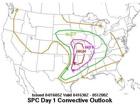
X 40. That is by far the largest I've ever seen and dwarfs even April 27, 2011...must be the largest ever since the SPC began. The floodgates of hell are opening today. Was wondering if 60% hatched for the first time before the actual tornadoes start would be issued but not yet. There is a good chance to see the 2nd only 60% tornado hatched area ever given today.
CrazyC83 wrote:Southern area has some potential for busting indeed. However, it does appear that the atmosphere is clearing out with the storms well to the east now.
If you have time, you should go back and see what was happening overnight. Hook echoes were popping out of the line blobs out of nowhere and they weren't TOR warned.
Texas Snowman wrote:Probably a little wishful thinking on my part - who needs an outbreak of strong, long-tracked tornadoes - but I keep hearing from various sources an idea that supercell coverage on the southern end of the high risk may be somewhat limited.
With the worked over atmosphere from last night's storms in portions of Oklahoma, can't help but wonder if there's any potential for a "bust" of sorts today - i.e. lots of storm chasers looking at radars that aren't lit up as expected.
On your first point, that could actually be better for the intense supercells that do form because less interaction leaves more for what's there. The problem of too many cells in a confined space would be a total non-issue. It's very unclear in general.
Second thing, worked over? It wasn't worked over at all but what it may have done is cleared the way for no morning convection so that could end up making storms later on worse. Last nights storms can also lay down boundaries.