Plains Tornado Outbreak 4/14-15

U.S. & Caribbean Weather Discussions and Severe Weather Events

Moderator: S2k Moderators

Forum rules

The posts in this forum are NOT official forecast and should not be used as such. They are just the opinion of the poster and may or may not be backed by sound meteorological data. They are NOT endorsed by any professional institution or STORM2K.

Help Support Storm2K
Message
Author
User avatar
vbhoutex
Storm2k Executive
Storm2k Executive
Posts: 29112
Age: 73
Joined: Wed Oct 09, 2002 11:31 pm
Location: Cypress, TX
Contact:

Re:

#621 Postby vbhoutex » Sat Apr 14, 2012 7:04 pm

RL3AO wrote:I think when it comes to the tropics I'll put s2k up against anyone for good information.

For severe weather, there are dozens of better sources. One solution in the future might be just to make a warnings thread for big events like we do with Atlantic storms.

That is what I thought these threads are for, not just discussion. I understand that there are other better sources for information. We are just making another source available. Too many threads about a weather situation could also confuse those that do come here for information. You might be surprised how many do come here if they are surfing for info. I'm not saying we are a main source, I am saying we are a source as we do have people that tell us they found us while looking for info on the weather they were looking for/experiencing. I guess my question would be, why even post any warnings, instead of just talking about what we are picking up from the different sources we use if this is just and "enthusiasts" thread?
And yes this discussion can be held later. Nothing has to be worked out right now.
0 likes   
Skywarn, C.E.R.T.
Please click below to donate to STORM2K to help with the expenses of keeping the site going:
Image

CrazyC83
Professional-Met
Professional-Met
Posts: 34002
Joined: Tue Mar 07, 2006 11:57 pm
Location: Deep South, for the first time!

#622 Postby CrazyC83 » Sat Apr 14, 2012 7:05 pm

Haven't heard of any significant damage in Salina. Wow, they sure dodged a HUGE bullet...
0 likes   

User avatar
Texas Snowman
Storm2k Moderator
Storm2k Moderator
Posts: 6179
Joined: Fri Jan 25, 2008 11:29 am
Location: Denison, Texas

Re:

#623 Postby Texas Snowman » Sat Apr 14, 2012 7:06 pm

CrazyC83 wrote:SW Oklahoma: STP over 10, EHI over 12...insanely high...


Yeah, I'm really surprised that there hasn't been more happen in Oklahoma yet.
0 likes   
The above post and any post by Texas Snowman is NOT an official forecast and should not be used as such. It is just the opinion of the poster and may or may not be backed by sound meteorological data. It is NOT endorsed by any professional institution including storm2k.org. For official information, please refer to NWS products.

User avatar
Bunkertor
Category 5
Category 5
Posts: 3397
Joined: Tue May 09, 2006 3:48 pm

Re: Re:

#624 Postby Bunkertor » Sat Apr 14, 2012 7:08 pm

Texas Snowman wrote:
CrazyC83 wrote:SW Oklahoma: STP over 10, EHI over 12...insanely high...


Yeah, I'm really surprised that there hasn't been more happen in Oklahoma yet.


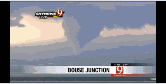
2 forming @ NEWS9 right now. Multivortex.
Last edited by Bunkertor on Sat Apr 14, 2012 7:12 pm, edited 1 time in total.
0 likes   

User avatar
vbhoutex
Storm2k Executive
Storm2k Executive
Posts: 29112
Age: 73
Joined: Wed Oct 09, 2002 11:31 pm
Location: Cypress, TX
Contact:

Re: Plains Tornado Outbreak: High Risk on 4/14-15 at OK,KS,NEB

#625 Postby vbhoutex » Sat Apr 14, 2012 7:10 pm

Larry Cosgrove told me yesterday that he didn't expect this to be as major of an outbreak as many were suggesting, because he didn't see the cap breaking soon enough for everything to power up as has been suggested previously in discussions. I am certainly not downplaying this either, but it does appear that it could be less than previously thought, which is good.
0 likes   
Skywarn, C.E.R.T.
Please click below to donate to STORM2K to help with the expenses of keeping the site going:
Image

apocalypt-flyer
Category 1
Category 1
Posts: 468
Joined: Sat Aug 27, 2005 11:51 am

#626 Postby apocalypt-flyer » Sat Apr 14, 2012 7:11 pm

Yes, multiple vortex Tornado nearby Bouse Junction. South of Waynoka. It's a big one.
Last edited by apocalypt-flyer on Sat Apr 14, 2012 7:12 pm, edited 1 time in total.
0 likes   

User avatar
Texas Snowman
Storm2k Moderator
Storm2k Moderator
Posts: 6179
Joined: Fri Jan 25, 2008 11:29 am
Location: Denison, Texas

#627 Postby Texas Snowman » Sat Apr 14, 2012 7:11 pm

Yeah, but I don't see anything forming that is going to impact central Oklahoma yet.

I know the STP are super high, but so far the high risk for Oklahoma is proving to be a bust.

I hope I don't have to eat those words later on tonight.
0 likes   
The above post and any post by Texas Snowman is NOT an official forecast and should not be used as such. It is just the opinion of the poster and may or may not be backed by sound meteorological data. It is NOT endorsed by any professional institution including storm2k.org. For official information, please refer to NWS products.

CrazyC83
Professional-Met
Professional-Met
Posts: 34002
Joined: Tue Mar 07, 2006 11:57 pm
Location: Deep South, for the first time!

#628 Postby CrazyC83 » Sat Apr 14, 2012 7:13 pm

It turns out Kansas - which was BETWEEN the two High Risk areas initially - has seen all the activity so far.
0 likes   

User avatar
Bunkertor
Category 5
Category 5
Posts: 3397
Joined: Tue May 09, 2006 3:48 pm

#629 Postby Bunkertor » Sat Apr 14, 2012 7:14 pm

Huge Cone on the ground. Huge.
0 likes   

Peanut432
Tropical Storm
Tropical Storm
Posts: 119
Joined: Mon Jan 25, 2010 10:21 pm
Location: Hollis Ok

Re:

#630 Postby Peanut432 » Sat Apr 14, 2012 7:16 pm

apocalypt-flyer wrote:Yes, multiple vortex Tornado nearby Bouse Junction. South of Waynoka. It's a big one.

Watching it on koco live..... large wedge Tornado :double:
0 likes   

CrazyC83
Professional-Met
Professional-Met
Posts: 34002
Joined: Tue Mar 07, 2006 11:57 pm
Location: Deep South, for the first time!

Re: Plains Tornado Outbreak: High Risk on 4/14-15 at OK,KS,NEB

#631 Postby CrazyC83 » Sat Apr 14, 2012 7:20 pm

MESOSCALE DISCUSSION 0535
NWS STORM PREDICTION CENTER NORMAN OK
0715 PM CDT SAT APR 14 2012

AREAS AFFECTED...NW AND N CNTRL OK INTO NE KS

CONCERNING...TORNADO WATCH 170...

VALID 150015Z - 150115Z

THE SEVERE WEATHER THREAT FOR TORNADO WATCH 170 CONTINUES.

LONG-LIVED...MODESTLY FAST MOVING SUPERCELLS WITH THE POTENTIAL FOR
ISOLATED STRONG TORNADOES WILL PERSIST THIS EVENING.


SEVERAL DISCRETE SUPERCELLS CONTINUE MOVE NORTHEASTWARD AROUND 30
KT...THROUGH THE OPEN WARM SECTOR OF THE DEEPENING CYCLONE CENTERED
OVER THE HIGH PLAINS. MID-LEVEL FORCING FOR UPWARD VERTICAL MOTION
REMAINS WEAK/UNCERTAIN ACROSS NORTH CENTRAL OKLAHOMA AND
CENTRAL/EASTERN KANSAS...AND INHIBITION FOR BOUNDARY LAYER PARCELS
MAY BEGIN TO INCREASE SOME WITH SURFACE COOLING. HOWEVER...BENEATH
DIFLUENT AND AT LEAST WEAKLY DIVERGENT HIGH LEVEL FLOW...STORM-SCALE
DYNAMICS MAY BE STRONG ENOUGH TO MAINTAIN ACTIVITY INTO AT LEAST THE
02-04Z TIME FRAME. CELLS APPEAR GENERALLY FOCUSED ALONG THE
INTENSIFYING LOW-LEVEL JET AXIS /50-70 KT AT 850 MB/...WHERE
ENLARGING CLOCKWISE CURVED LOW-LEVEL HODOGRAPHS WILL STILL SUPPORT
THE RISK FOR STRONG TORNADOES.

THE HIGHEST TORNADIC POTENTIAL MAY BE WITH CELLS DEVELOPING
NORTHEASTWARD FROM NORTH CENTRAL OKLAHOMA INTO SOUTH CENTRAL
KANSAS...NEAR/SOUTH OF WICHITA...ASSOCIATED WITH INFLOW OF AT LEAST
A BIT MORE MOIST AND UNSTABLE AIR THAN CELLS FARTHER NORTH.

OTHERWISE...NW STORM DEVELOPMENT WILL CONTINUE BACK TO THE WEST
ALONG THE DRY LINE ACROSS THE HIGHER PLAINS...WHICH HAS ACTUALLY
RETREATED WESTWARD SOME THE PAST HOUR OR TWO.

..KERR.. 04/15/2012


ATTN...WFO...TOP...ICT...OUN...DDC...

LAT...LON 36589878 37919790 39239719 39889605 39339580 36969720
36159847 36199879 36589878
0 likes   

WeatherGuesser
Category 5
Category 5
Posts: 2672
Joined: Tue Jun 29, 2010 6:46 am

Re:

#632 Postby WeatherGuesser » Sat Apr 14, 2012 7:21 pm

Bunkertor wrote:Huge Cone on the ground. Huge.


City? State? County?
0 likes   

CrazyC83
Professional-Met
Professional-Met
Posts: 34002
Joined: Tue Mar 07, 2006 11:57 pm
Location: Deep South, for the first time!

#633 Postby CrazyC83 » Sat Apr 14, 2012 7:22 pm

KWTV: South of Waynoka, OK - tornado hit an large oil tank directly and exploded it, massive fire
Last edited by CrazyC83 on Sat Apr 14, 2012 7:22 pm, edited 1 time in total.
0 likes   

User avatar
Texas Snowman
Storm2k Moderator
Storm2k Moderator
Posts: 6179
Joined: Fri Jan 25, 2008 11:29 am
Location: Denison, Texas

#634 Postby Texas Snowman » Sat Apr 14, 2012 7:22 pm

Multiple vortex was - WAS - on the ground near Waynoka, Okla.

It has temporarily lifted up.

Apparently hit an oil facility and caused a big fire per one of the TV stations w/a copter following it.

EDIT: the tornado - which was either a multi-vortex or two separate twisters at one point - hit a tank battery. Big fire at that tank battery.
0 likes   
The above post and any post by Texas Snowman is NOT an official forecast and should not be used as such. It is just the opinion of the poster and may or may not be backed by sound meteorological data. It is NOT endorsed by any professional institution including storm2k.org. For official information, please refer to NWS products.

User avatar
Bunkertor
Category 5
Category 5
Posts: 3397
Joined: Tue May 09, 2006 3:48 pm

#635 Postby Bunkertor » Sat Apr 14, 2012 7:26 pm

Image
0 likes   

User avatar
Bunkertor
Category 5
Category 5
Posts: 3397
Joined: Tue May 09, 2006 3:48 pm

Re: Re:

#636 Postby Bunkertor » Sat Apr 14, 2012 7:29 pm

WeatherGuesser wrote:
Bunkertor wrote:Huge Cone on the ground. Huge.


City? State? County?


Sorry mate. Tought, you were watching News9 as well.
0 likes   

CrazyC83
Professional-Met
Professional-Met
Posts: 34002
Joined: Tue Mar 07, 2006 11:57 pm
Location: Deep South, for the first time!

#637 Postby CrazyC83 » Sat Apr 14, 2012 7:32 pm

Second area of storms redeveloping much farther west where it started today. Dryline retreated...
0 likes   

User avatar
vbhoutex
Storm2k Executive
Storm2k Executive
Posts: 29112
Age: 73
Joined: Wed Oct 09, 2002 11:31 pm
Location: Cypress, TX
Contact:

Re: Re:

#638 Postby vbhoutex » Sat Apr 14, 2012 7:32 pm

Bunkertor wrote:
WeatherGuesser wrote:
Bunkertor wrote:Huge Cone on the ground. Huge.


City? State? County?


Sorry mate. Tought, you were watching News9 as well.

Confirming this as I am watching. Multivortex on the ground again 8 mi S of Alva. Appears to be lifting and dropping. Still some structures in front of it. Now reporting power flashes , without typical condensation funnel.
0 likes   
Skywarn, C.E.R.T.
Please click below to donate to STORM2K to help with the expenses of keeping the site going:
Image

User avatar
Bunkertor
Category 5
Category 5
Posts: 3397
Joined: Tue May 09, 2006 3:48 pm

#639 Postby Bunkertor » Sat Apr 14, 2012 7:34 pm

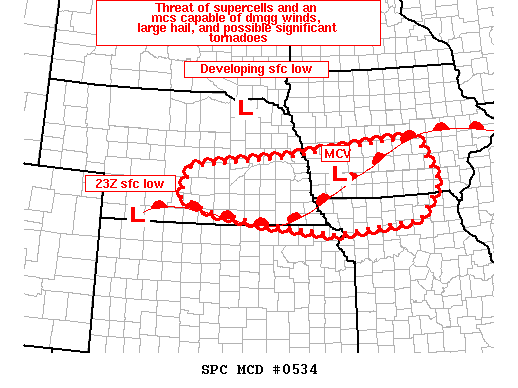
MESOSCALE DISCUSSION 0534
NWS STORM PREDICTION CENTER NORMAN OK
0657 PM CDT SAT APR 14 2012

AREAS AFFECTED...SERN NEB...SRN IA...NRN MO...NERN KS

CONCERNING...TORNADO WATCH 167...169...171...
Image
VALID 142357Z - 150100Z

THE SEVERE WEATHER THREAT FOR TORNADO WATCH
167...169...171...CONTINUES.

A NEW WW HAS BEEN ISSUED FOR PORTIONS OF SERN NEB FOR POTENTIAL NEW
DEVELOPMENT AND ONGOING CONVECTION TO THE WEST OF AN EXITING MCS.
INTENSIFICATION OF STORMS REMAINS POSSIBLE ACROSS SRN IA...AND NRN
MO...ESPECIALLY IN ADVANCE OF A BOWING SEGMENT OVER SWRN IA.

23Z SURFACE ANALYSIS REFLECTS A DEEPENING SURFACE LOW OVER NWRN
KS/SWRN NEB...WITH SURFACE PRESSURE FALLS NOTED OVER NERN NEB/NWRN
IA IN RESPONSE TO HEIGHT FALLS ALOFT / A VORT MAX NOTED ON WV
IMAGERY OVER SERN WY/NERN CO. WITH A SURFACE LOW DEVELOPING INTO
NERN NEB...NOTABLE BACKING IS PROJECTED ACROSS FAR ERN NEB AND IA.
AREA VAD WIND PROFILE DATA IS ALREADY SHOWING SIGNIFICANT
STRENGTHENING OF LOW LEVEL WINDS.../50 KT AT 1000 FT ACROSS NERN
KS/NWRN MO...WITH HODOGRAPHS LARGELY BECOMING FAVORABLE FOR
SUPERCELLS CAPABLE OF DMGG WINDS...LARGE HAIL...AND POTENTIALLY
SIGNIFICANT TORNADOES. WARM ADVECTION REGIME WILL CONTINUE TO
SUPPORT A DESTABILIZING/RECOVERING AIR MASS...WITH NEW DEVELOPMENT
OF STORMS POSSIBLE.

..HURLBUT.. 04/14/2012
0 likes   

RL3AO
Moderator-Pro Met
Moderator-Pro Met
Posts: 16308
Joined: Thu Jun 14, 2007 10:03 pm
Location: NC

Re:

#640 Postby RL3AO » Sat Apr 14, 2012 7:35 pm

CrazyC83 wrote:Second area of storms redeveloping much farther west where it started today. Dryline retreated...


This could be the real outbreak.
0 likes   


Return to “USA & Caribbean Weather”

Who is online

Users browsing this forum: No registered users and 26 guests