Plains Tornado Outbreak 4/14-15

U.S. & Caribbean Weather Discussions and Severe Weather Events

Moderator: S2k Moderators

Forum rules

The posts in this forum are NOT official forecast and should not be used as such. They are just the opinion of the poster and may or may not be backed by sound meteorological data. They are NOT endorsed by any professional institution or STORM2K.

Help Support Storm2K
Message
Author
User avatar
Cyclenall
Category 5
Category 5
Posts: 6666
Joined: Thu Jun 08, 2006 10:01 pm
Location: Ontario, Canada

Not surprised to see cliches used already

#641 Postby Cyclenall » Sat Apr 14, 2012 7:37 pm

Bunkertor wrote:Image

Why does the image look like this? Weird style there.

Not surprised to see people already commenting on "bust" here and "could have been worse/dodged a bullet" there :roll: . We're already way beyond what was expected up to this point in tornado reports...some models didn't even show cells firing for the most part until now. With that said, I'm confused as to why there isn't more aerial coverage up north and slight delay of most intense supercell part of outbreak in general. Multiple rounds of storms firing is likely and the storms haven't hit the most densely populated areas yet.
0 likes   

CrazyC83
Professional-Met
Professional-Met
Posts: 34002
Joined: Tue Mar 07, 2006 11:57 pm
Location: Deep South, for the first time!

#642 Postby CrazyC83 » Sat Apr 14, 2012 7:38 pm

54 tornadoes so far. Hardly a bust.

I think it is because they have focused on rural areas, which is a GOOD thing.
0 likes   

WeatherGuesser
Category 5
Category 5
Posts: 2672
Joined: Tue Jun 29, 2010 6:46 am

#643 Postby WeatherGuesser » Sat Apr 14, 2012 7:38 pm

DDC, New SVRs posted.
0 likes   

RL3AO
Moderator-Pro Met
Moderator-Pro Met
Posts: 16308
Joined: Thu Jun 14, 2007 10:03 pm
Location: NC

#644 Postby RL3AO » Sat Apr 14, 2012 7:38 pm

Image
0 likes   

User avatar
Bunkertor
Category 5
Category 5
Posts: 3397
Joined: Tue May 09, 2006 3:48 pm

#645 Postby Bunkertor » Sat Apr 14, 2012 7:39 pm

MESOSCALE DISCUSSION 0535
NWS STORM PREDICTION CENTER NORMAN OK
0715 PM CDT SAT APR 14 2012

AREAS AFFECTED...NW AND N CNTRL OK INTO NE KS

CONCERNING...TORNADO WATCH 170...
Image
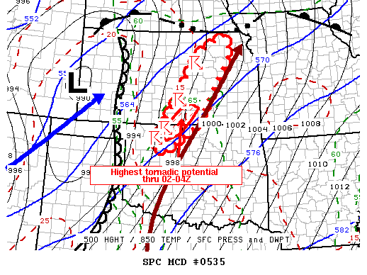
VALID 150015Z - 150115Z

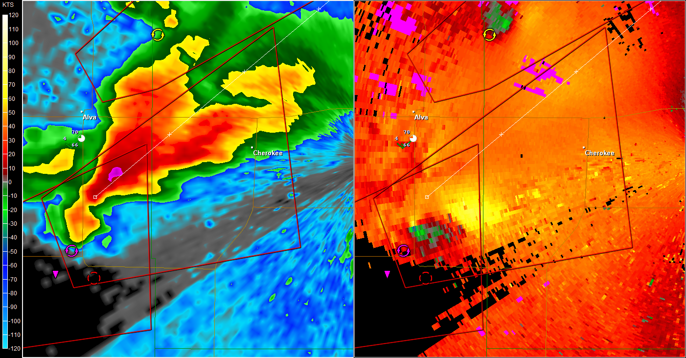
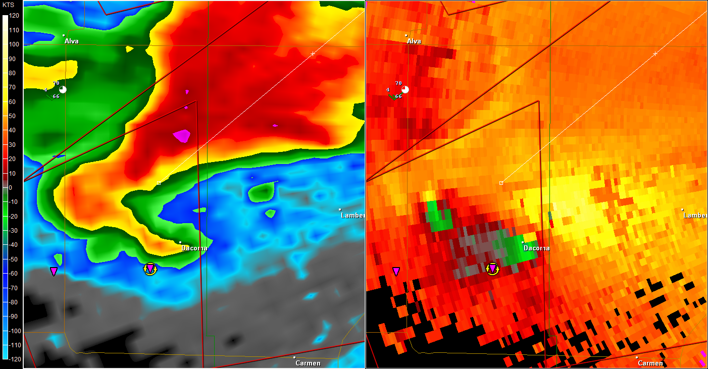
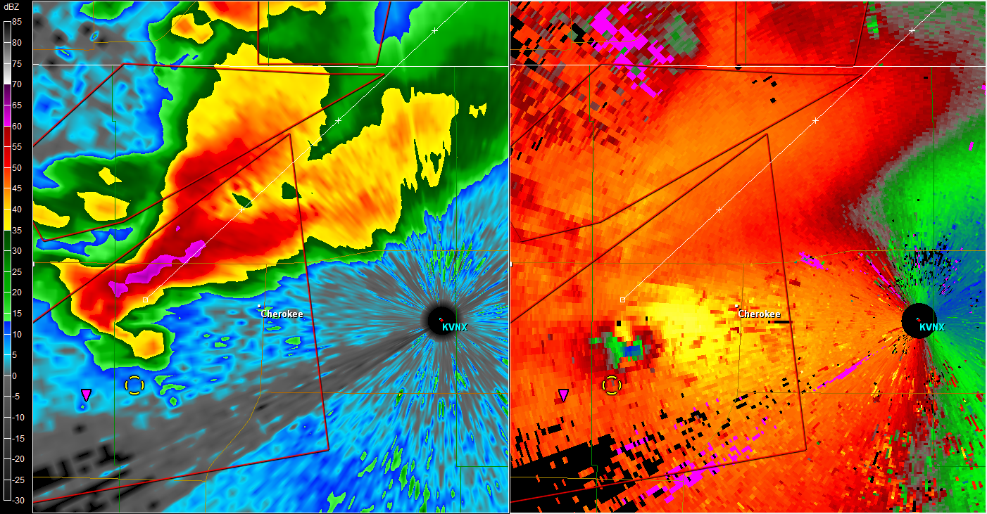
THE SEVERE WEATHER THREAT FOR TORNADO WATCH 170 CONTINUES.

LONG-LIVED...MODESTLY FAST MOVING SUPERCELLS WITH THE POTENTIAL FOR
ISOLATED STRONG TORNADOES WILL PERSIST THIS EVENING.

SEVERAL DISCRETE SUPERCELLS CONTINUE MOVE NORTHEASTWARD AROUND 30
KT...THROUGH THE OPEN WARM SECTOR OF THE DEEPENING CYCLONE CENTERED
OVER THE HIGH PLAINS. MID-LEVEL FORCING FOR UPWARD VERTICAL MOTION
REMAINS WEAK/UNCERTAIN ACROSS NORTH CENTRAL OKLAHOMA AND
CENTRAL/EASTERN KANSAS...AND INHIBITION FOR BOUNDARY LAYER PARCELS
MAY BEGIN TO INCREASE SOME WITH SURFACE COOLING. HOWEVER...BENEATH
DIFLUENT AND AT LEAST WEAKLY DIVERGENT HIGH LEVEL FLOW...STORM-SCALE
DYNAMICS MAY BE STRONG ENOUGH TO MAINTAIN ACTIVITY INTO AT LEAST THE
02-04Z TIME FRAME. CELLS APPEAR GENERALLY FOCUSED ALONG THE
INTENSIFYING LOW-LEVEL JET AXIS /50-70 KT AT 850 MB/...WHERE
ENLARGING CLOCKWISE CURVED LOW-LEVEL HODOGRAPHS WILL STILL SUPPORT
THE RISK FOR STRONG TORNADOES.

THE HIGHEST TORNADIC POTENTIAL MAY BE WITH CELLS DEVELOPING
NORTHEASTWARD FROM NORTH CENTRAL OKLAHOMA INTO SOUTH CENTRAL
KANSAS...NEAR/SOUTH OF WICHITA...ASSOCIATED WITH INFLOW OF AT LEAST
A BIT MORE MOIST AND UNSTABLE AIR THAN CELLS FARTHER NORTH.

OTHERWISE...NW STORM DEVELOPMENT WILL CONTINUE BACK TO THE WEST
ALONG THE DRY LINE ACROSS THE HIGHER PLAINS...WHICH HAS ACTUALLY
RETREATED WESTWARD SOME THE PAST HOUR OR TWO.

..KERR.. 04/15/2012
0 likes   

User avatar
vbhoutex
Storm2k Executive
Storm2k Executive
Posts: 29112
Age: 73
Joined: Wed Oct 09, 2002 11:31 pm
Location: Cypress, TX
Contact:

Re: Plains Tornado Outbreak: High Risk on 4/14-15 at OK,KS,NEB

#646 Postby vbhoutex » Sat Apr 14, 2012 7:43 pm

New9 reporting tornado approaching the high school in Dacoma, OK right now.
0 likes   
Skywarn, C.E.R.T.
Please click below to donate to STORM2K to help with the expenses of keeping the site going:
Image

User avatar
Bunkertor
Category 5
Category 5
Posts: 3397
Joined: Tue May 09, 2006 3:48 pm

Re: Not surprised to see cliches used already

#647 Postby Bunkertor » Sat Apr 14, 2012 7:45 pm

Cyclenall wrote:
Bunkertor wrote:Image

Why does the image look like this? Weird style there.


I´m an artist. No, ahm, it has got someting to do with the video-acceleration. But i can´t tell you more, not a PC specialist.
0 likes   

RL3AO
Moderator-Pro Met
Moderator-Pro Met
Posts: 16308
Joined: Thu Jun 14, 2007 10:03 pm
Location: NC

#648 Postby RL3AO » Sat Apr 14, 2012 7:46 pm

Two couplets.

Image
0 likes   

RL3AO
Moderator-Pro Met
Moderator-Pro Met
Posts: 16308
Joined: Thu Jun 14, 2007 10:03 pm
Location: NC

#649 Postby RL3AO » Sat Apr 14, 2012 7:50 pm

New tornado moving towards the chaser on News 9.
0 likes   

User avatar
brunota2003
S2K Supporter
S2K Supporter
Posts: 9476
Age: 34
Joined: Sat Jul 30, 2005 9:56 pm
Location: Stanton, KY...formerly Havelock, NC
Contact:

#650 Postby brunota2003 » Sat Apr 14, 2012 7:50 pm

Link to streaming video? Who is Channel 9?
0 likes   

RL3AO
Moderator-Pro Met
Moderator-Pro Met
Posts: 16308
Joined: Thu Jun 14, 2007 10:03 pm
Location: NC

Re:

#651 Postby RL3AO » Sat Apr 14, 2012 7:51 pm

brunota2003 wrote:Link to streaming video? Who is Channel 9?

http://www.news9.com/

Click the "watch live now" banner.
0 likes   

Halah
Tropical Low
Tropical Low
Posts: 24
Joined: Tue May 10, 2005 6:45 pm
Location: Hilliard, OH

Re:

#652 Postby Halah » Sat Apr 14, 2012 7:52 pm

RL3AO wrote:Two couplets.


Guy on news9 said there was a rope tornado behind the main one. Probably the one on the left in your pic.
0 likes   

User avatar
vbhoutex
Storm2k Executive
Storm2k Executive
Posts: 29112
Age: 73
Joined: Wed Oct 09, 2002 11:31 pm
Location: Cypress, TX
Contact:

Re: Plains Tornado Outbreak: High Risk on 4/14-15 at OK,KS,NEB

#653 Postby vbhoutex » Sat Apr 14, 2012 7:53 pm

News 9 confirming large Multivortex on the ground just NW of Dacoma. Debris clouds still visible on the ground without normal condensation funnels. Lifting up and down with a classic wall cloud visible.
0 likes   
Skywarn, C.E.R.T.
Please click below to donate to STORM2K to help with the expenses of keeping the site going:
Image

CrazyC83
Professional-Met
Professional-Met
Posts: 34002
Joined: Tue Mar 07, 2006 11:57 pm
Location: Deep South, for the first time!

#654 Postby CrazyC83 » Sat Apr 14, 2012 7:53 pm

MESOSCALE DISCUSSION 0536
NWS STORM PREDICTION CENTER NORMAN OK
0750 PM CDT SAT APR 14 2012

AREAS AFFECTED...ERN IA

CONCERNING...SEVERE POTENTIAL...WATCH POSSIBLE

VALID 150050Z - 150145Z

AN ORGANIZED BOWING SEGMENT CONTINUES TO TRACK EWD...AND IS EXPECTED
TO PROGRESS TO THE ERN PORTION OF WW 169 BY 02Z. THE SYSTEM MAY
WEAKEN WITH TIME...BUT ITS ORGANIZATION WILL CONTINUE TO BE
MONITORED...WITH THE POSSIBILITY OF A DOWNSTREAM SEVERE WW.

AN MCV LOCATED JUST EAST OF ATLANTIC IA CONTINUES TO TRACK
EWD...WITH AN ORGANIZED COLD POOL NOW EVIDENT. ALTHOUGH CONDITIONS
REMAIN FAVORABLE FOR DMGG WINDS AND POSSIBLE EMBEDDED MESOVORTICES
ATTM...DOWNSTREAM 00Z SOUNDINGS SHOW LIMITED
INSTABILITY/MOISTURE...WHICH MAY WEAKEN THE SYSTEM AS IT APPROACHES
THE ERN EXTENT OF WW 169. HOWEVER...A STRENGTHENING LOW LEVEL JET
COULD LEAD TO AT LEAST WEAK MOISTURE RETURN...WITH A SUPPORTING
UPPER WAVE NOTED ON WV IMAGERY ACROSS ERN NEB POSSIBLY SUSTAINING
THE BOWING SEGMENT. AS SUCH...ISOLATED OCCURRENCES OF DMGG WINDS
AND/OR HAIL WILL BE POSSIBLE.

..HURLBUT.. 04/15/2012


ATTN...WFO...DVN...DMX...

LAT...LON 41859289 42619203 42419093 41869064 41279087 40789136
40519174 40609233 41519282 41859289
0 likes   

RL3AO
Moderator-Pro Met
Moderator-Pro Met
Posts: 16308
Joined: Thu Jun 14, 2007 10:03 pm
Location: NC

#655 Postby RL3AO » Sat Apr 14, 2012 7:53 pm

Image

Velocities picking up. Steamer is 3 miles south of Cherokee.
0 likes   

RL3AO
Moderator-Pro Met
Moderator-Pro Met
Posts: 16308
Joined: Thu Jun 14, 2007 10:03 pm
Location: NC

Re: Re:

#656 Postby RL3AO » Sat Apr 14, 2012 7:54 pm

Halah wrote:
RL3AO wrote:Two couplets.


Guy on news9 said there was a rope tornado behind the main one. Probably the one on the left in your pic.


Yep. Its gone now. New circulation getting stronger.
0 likes   

CrazyC83
Professional-Met
Professional-Met
Posts: 34002
Joined: Tue Mar 07, 2006 11:57 pm
Location: Deep South, for the first time!

#657 Postby CrazyC83 » Sat Apr 14, 2012 7:54 pm

MESOSCALE DISCUSSION 0537
NWS STORM PREDICTION CENTER NORMAN OK
0751 PM CDT SAT APR 14 2012

AREAS AFFECTED...NE NEB...SERN SOUTH DAKOTA NW IA

CONCERNING...SEVERE POTENTIAL...WATCH UNLIKELY

VALID 150051Z - 150215Z

STRONGEST SURFACE PRESSURE FALLS ACROSS THE CENTRAL PLAINS HAVE
RECENTLY BECOME FOCUSED ACROSS THE MID MISSOURI VALLEY AREA
...AROUND YANKTON/SIOUX FALLS AND SIOUX CITY. THIS IS LIKELY
REFLECTIVE OF A STRENGTHENING LOWER/MID TROPOSPHERIC WARM ADVECTION
REGIME...WHICH PROBABLY WILL SUPPORT INCREASING CONVECTIVE
DEVELOPMENT THROUGH 02-04Z. THIS ACTIVITY WILL BE ROOTED WITHIN A
MOISTENING LAYER ABOVE A LINGERING NEAR SURFACE STABLE LAYER...TO
THE NORTH OF A WARM FRONT. WHILE IT IS POSSIBLE THAT MID-LEVEL
INSTABILITY MAY BE SUFFICIENT TO SUPPORT THE RISK FOR SOME LARGE
HAIL IN STRONGER STORMS...THE SEVERE POTENTIAL CURRENTLY SEEMS TOO
LOW TO REQUIRE A WATCH.

..KERR.. 04/15/2012


ATTN...WFO...DMX...FSD...OAX...LBF...

LAT...LON 43879900 44399719 44269603 43449530 42259545 41489616
41979736 42699823 42849891 43879900
0 likes   

User avatar
brunota2003
S2K Supporter
S2K Supporter
Posts: 9476
Age: 34
Joined: Sat Jul 30, 2005 9:56 pm
Location: Stanton, KY...formerly Havelock, NC
Contact:

#658 Postby brunota2003 » Sat Apr 14, 2012 7:56 pm

Thanks...tornado is back on the ground.
0 likes   

CrazyC83
Professional-Met
Professional-Met
Posts: 34002
Joined: Tue Mar 07, 2006 11:57 pm
Location: Deep South, for the first time!

#659 Postby CrazyC83 » Sat Apr 14, 2012 7:56 pm

Headed for Cherokee. Could be REALLY ugly, folks!
0 likes   

RL3AO
Moderator-Pro Met
Moderator-Pro Met
Posts: 16308
Joined: Thu Jun 14, 2007 10:03 pm
Location: NC

#660 Postby RL3AO » Sat Apr 14, 2012 7:56 pm

Going to track near or just north of Cherokee, OK.
0 likes   


Return to “USA & Caribbean Weather”

Who is online

Users browsing this forum: snownado and 23 guests