Texas Spring 2012

U.S. & Caribbean Weather Discussions and Severe Weather Events

Moderator: S2k Moderators

Forum rules

The posts in this forum are NOT official forecast and should not be used as such. They are just the opinion of the poster and may or may not be backed by sound meteorological data. They are NOT endorsed by any professional institution or STORM2K.

Help Support Storm2K
Message
Author
User avatar
Rgv20
S2K Supporter
S2K Supporter
Posts: 2466
Age: 38
Joined: Wed Jan 05, 2011 5:42 pm
Location: Edinburg/McAllen Tx

#281 Postby Rgv20 » Thu Apr 19, 2012 12:08 am

Looks like we may have a chance of some severe storms in the RGV come Friday. The NAM,GFS, and ECMWF forecasting a descent shot of severe weather for South Texas come Friday afternoon.

Image
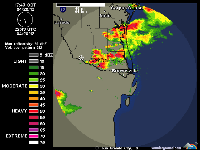
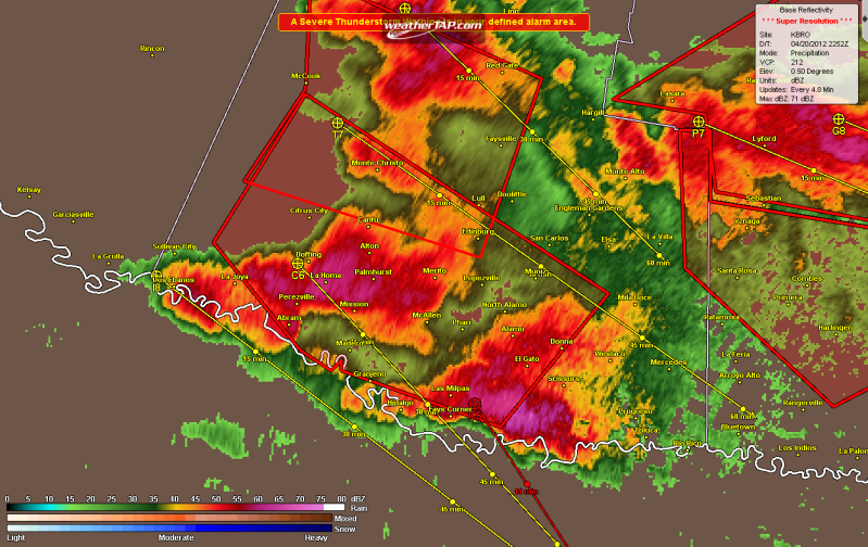
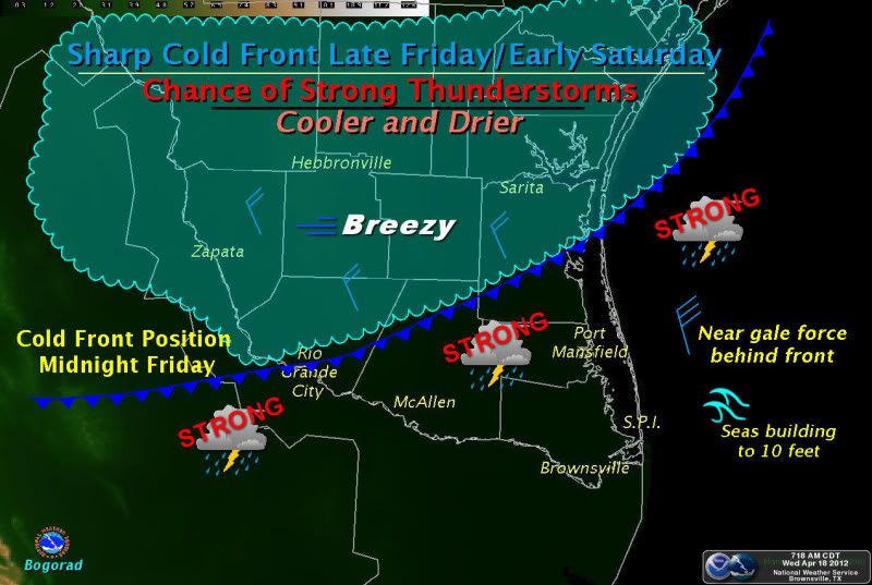
A sharp fast moving cold front is forecast to move through Deep South Texas and Rio Grande Valley Friday night. There is a chance of strong thunderstorms along the front producing areas of heavy rain. Cooler and drier air riding on Northwest to North winds of 15 to 25 mph will over spread the region by Saturday morning leading to a beautiful weekend. Hazardous marine conditions anticipated Friday night into early Saturday with the frontal passage. Much improved conditions later Saturday. -Bogorad-
0 likes   
The following post is NOT an official forecast and should not be used as such. It is just the opinion of the poster and may or may not be backed by sound meteorological data. It is NOT endorsed by any professional institution including storm2k.org For Official Information please refer to the NHC and NWS products.

User avatar
cctxhurricanewatcher
Category 5
Category 5
Posts: 1206
Joined: Sun Sep 12, 2004 8:53 pm
Location: Corpus Christi, Texas

#282 Postby cctxhurricanewatcher » Thu Apr 19, 2012 9:37 am

:uarrow: :uarrow:

RGV,

We've had enough of this severe weather stuff down in these parts this spring. Personally, I've managed to avoid the hail, destructive winds, etc and have loved the rain. Just don't what to be next in line if you know what I mean.
0 likes   

User avatar
Rgv20
S2K Supporter
S2K Supporter
Posts: 2466
Age: 38
Joined: Wed Jan 05, 2011 5:42 pm
Location: Edinburg/McAllen Tx

#283 Postby Rgv20 » Fri Apr 20, 2012 9:10 am

:uarrow: I too have been lucky enough to avoid severe weather but the rain has been nice :D This evening and tonight could be rough for parts of South Texas..

Special Weather Statement

SPECIAL WEATHER STATEMENT
NATIONAL WEATHER SERVICE BROWNSVILLE TX
500 AM CDT FRI APR 20 2012

TXZ248>257-201700-
ZAPATA-JIM HOGG-BROOKS-KENEDY-STARR-HIDALGO-INLAND WILLACY-
INLAND CAMERON-COASTAL WILLACY-COASTAL CAMERON-
INCLUDING THE CITIES OF...ZAPATA...HEBBRONVILLE...FALFURRIAS...
SARITA...RIO GRANDE CITY...ROMA...MCALLEN...EDINBURG...PHARR...
MISSION...WESLACO...RAYMONDVILLE...BROWNSVILLE...HARLINGEN...
PORT MANSFIELD...PORT ISABEL...SOUTH PADRE ISLAND...
LAGUNA HEIGHTS...LAGUNA VISTA
500 AM CDT FRI APR 20 2012

...STRONG TO SEVERE THUNDERSTORMS POSSIBLE TODAY...

A DISTURBANCE IN THE MIDDLE LAYERS OF THE ATMOSPHERE AND A COLD
FRONT AT THE SURFACE WILL PASS THROUGH DEEP SOUTH TEXAS AND THE
RIO GRANDE VALLEY THIS AFTERNOON AND EARLY TONIGHT...RESULTING IN
SCATTERED SHOWERS AND THUNDERSTORMS.

HEATING OF THE ATMOSPHERE WILL OCCUR THIS MORNING DUE TO ABUNDANT
SUNSHINE...WHILE BREEZY ONSHORE WINDS WILL PUMP MOISTURE INTO OUR
REGION FROM THE NEARBY GULF OF MEXICO. CONDITIONS WILL THEREFORE
BE RIPE BY THIS AFTERNOON AND EVENING FOR THUNDERSTORM DEVELOPMENT...
WHICH WILL OCCUR AS THE DISTURBANCE AND COLD FRONT APPROACH AND
MOVE THROUGH.

SCATTERED SHOWERS AND THUNDERSTORMS ARE ANTICIPATED...WITH SOME OF
THE THUNDERSTORMS POSSIBLY BECOMING SEVERE...PRODUCING LARGE HAIL
AND DAMAGING STRAIGHT-LINE WINDS. AN ISOLATED TORNADO CANNOT BE
RULED OUT.

RESIDENTS OF DEEP SOUTH TEXAS AND THE RIO GRANDE VALLEY ARE URGED
TO MONITOR THIS DEVELOPING WEATHER SITUATION TODAY...AND BE PREPARED
TO ACT IN THE EVENT THAT SEVERE WEATHER WARNINGS ARE ISSUED. FOR THE
MOST CURRENT WEATHER INFORMATION...MONITOR YOUR NATIONAL WEATHER
SERVICE OFFICE IN BROWNSVILLE THROUGH OUR WEBSITE...FACEBOOK PAGE...
NOAA WEATHER RADIO...OR LOCAL TELEVISION AND RADIO STATIONS.

$$

TOMASELLI


SPECIAL WEATHER STATEMENT
NATIONAL WEATHER SERVICE CORPUS CHRISTI TX
614 AM CDT FRI APR 20 2012

TXZ229>234-239>247-210000-
LA SALLE-MCMULLEN-LIVE OAK-BEE-GOLIAD-VICTORIA-WEBB-DUVAL-
JIM WELLS-KLEBERG-NUECES-SAN PATRICIO-ARANSAS-REFUGIO-CALHOUN-
INCLUDING THE CITIES OF...COTULLA...CALLIHAM...CROSS...
LOMA ALTA...TILDEN...GEORGE WEST...THREE RIVERS...BEEVILLE...
GOLIAD...VICTORIA...LAREDO...FREER...BENAVIDES...SAN DIEGO...
ALICE...ORANGE GROVE...KINGSVILLE...CORPUS CHRISTI...PORTLAND...
INGLESIDE...ARANSAS PASS...SINTON...MATHIS...ROCKPORT...REFUGIO...
WOODSBORO...PORT LAVACA
614 AM CDT FRI APR 20 2012

...SLIGHT RISK OF SEVERE THUNDERSTORMS OVER MOST OF SOUTH TEXAS
TODAY...

THERE IS A SLIGHT RISK FOR SEVERE THUNDERSTORMS THIS AFTERNOON AND
EARLY EVENING OVER SOUTH TEXAS...AS A STRONG COLD FRONT MOVES INTO
THE AREA. THE COLD FRONT IS EXPECTED TO MOVE THROUGH SAN ANTONIO
BY MIDDAY...REACHING THE COAST AROUND 6 PM. A LINE OF SHOWERS AND
THUNDERSTORMS IS EXPECTED TO DEVELOP ALONG THE FRONT. SOME STORMS
COULD BE SEVERE...PRODUCING LARGE HAIL AND DAMAGING STRAIGHT LINE
WINDS.

WHILE MOST OF SOUTH TEXAS IS HIGHLIGHTED FOR A SLIGHT RISK OF
SEVERE STORMS...THE PRIMARY CONCERN FOR SEVERE WEATHER IS
GENERALLY ALONG AND EAST OF HIGHWAY 281.

BECAUSE OF THE FAST MOVEMENT OF THIS SYSTEM...NO EXCESSIVE
RAINFALL OR FLOODING IS EXPECTED. RAINFALL TOTALS WILL AVERAGE
FROM ONE TENTH OF AN INCH OR LESS OVER THE BRUSH COUNTRY AND NEAR
LAREDO...TO AROUND 1/2 INCH ALONG THE COAST BETWEEN CORPUS CHRISTI
AND PORT LAVACA. ISOLATED AMOUNTS AROUND 1 INCH ARE ALSO POSSIBLE
ESPECIALLY IN THE VICTORIA CROSSROADS REGION.

WINDY CONDITIONS WILL DEVELOP ACROSS SOUTH TEXAS IN THE WAKE OF
THE FRONT TONIGHT INTO SATURDAY...AS MUCH COOLER AIR FILTERS INTO
THE REGION. NORTHWEST WINDS OF 20 TO 25 MPH WITH GUSTS TO 35 MPH
CAN BE EXPECTED...ESPECIALLY ALONG COASTAL AREAS. THE COMBINATION
OF STRONG WINDS AND LOW HUMIDITY VALUES MAY RESULT IN ELEVATED
FIRE WEATHER CONDITIONS ON SATURDAY ACROSS PARTS OF THE AREA.
SMALL CRAFT ADVISORY CONDITIONS ARE ALSO EXPECTED FOR THE BAYS AND
GULF WATERS...WITH GUSTS NEAR GALE FORCE POSSIBLE OVER THE
OFFSHORE GULF WATERS.

RESIDENTS AND MARINERS SHOULD BEGIN PREPARING FOR DEVELOPING
WEATHER SITUATION. KEEP INFORMED ON THE LATEST FORECASTS FROM THE
NATIONAL WEATHER SERVICE. KEEP INFORMED ON POSSIBLE WATCHES OR
WARNINGS BY LISTENING TO NOAA WEATHER RADIO...COMMERCIAL RADIO OR
TELEVISION. YOU CAN ALSO VISIT OUR WEBSITE AT...

http://WWW.WEATHER.GOV/CORPUSCHRISTI

$$

TB
0 likes   
The following post is NOT an official forecast and should not be used as such. It is just the opinion of the poster and may or may not be backed by sound meteorological data. It is NOT endorsed by any professional institution including storm2k.org For Official Information please refer to the NHC and NWS products.

User avatar
Rgv20
S2K Supporter
S2K Supporter
Posts: 2466
Age: 38
Joined: Wed Jan 05, 2011 5:42 pm
Location: Edinburg/McAllen Tx

#284 Postby Rgv20 » Fri Apr 20, 2012 3:02 pm

Severe Thunderstorm Watch

SEVERE THUNDERSTORM WATCH OUTLINE UPDATE FOR WS 185
NWS STORM PREDICTION CENTER NORMAN OK
230 PM CDT FRI APR 20 2012

SEVERE THUNDERSTORM WATCH 185 IS IN EFFECT UNTIL 1000 PM CDT
FOR THE FOLLOWING LOCATIONS

TXC047-061-131-215-247-249-261-273-297-311-355-409-427-479-489-
505-210300-
/O.NEW.KWNS.SV.A.0185.120420T1930Z-120421T0300Z/

TX
. TEXAS COUNTIES INCLUDED ARE

BROOKS CAMERON DUVAL
HIDALGO JIM HOGG JIM WELLS
KENEDY KLEBERG LIVE OAK
MCMULLEN NUECES SAN PATRICIO
STARR WEBB WILLACY
0 likes   
The following post is NOT an official forecast and should not be used as such. It is just the opinion of the poster and may or may not be backed by sound meteorological data. It is NOT endorsed by any professional institution including storm2k.org For Official Information please refer to the NHC and NWS products.

apocalypt-flyer
Category 1
Category 1
Posts: 468
Joined: Sat Aug 27, 2005 11:51 am

#285 Postby apocalypt-flyer » Fri Apr 20, 2012 3:43 pm

Tornado warning for the Corpus Christi area.
0 likes   

User avatar
Ntxw
Storm2k Moderator
Storm2k Moderator
Posts: 22731
Joined: Wed Oct 21, 2009 6:34 pm
Location: DFW, Texas

#286 Postby Ntxw » Fri Apr 20, 2012 4:16 pm

I think the CC area warning either dropped or expired, I couldn't find it, but there is a dangerous cell southwest of there and north of RGV

TORNADO WARNING
TXC247-202145-
/O.NEW.KBRO.TO.W.0009.120420T2112Z-120420T2145Z/

BULLETIN - EAS ACTIVATION REQUESTED
TORNADO WARNING
NATIONAL WEATHER SERVICE BROWNSVILLE TX
412 PM CDT FRI APR 20 2012

THE NATIONAL WEATHER SERVICE IN BROWNSVILLE HAS ISSUED A

* TORNADO WARNING FOR...
SOUTHEASTERN JIM HOGG COUNTY IN DEEP SOUTH TEXAS.

* UNTIL 445 PM CDT

* AT 412 PM CDT...NATIONAL WEATHER SERVICE METEOROLOGISTS DETECTED A
TORNADO OVER AGUA NUEVA...MOVING SOUTHEAST AT 30 MPH.

* THE TORNADO WILL BE NEAR...
AGUA NUEVA BY 410 PM CDT.

PRECAUTIONARY/PREPAREDNESS ACTIONS...

PLEASE REPORT TORNADOES OR FUNNEL CLOUDS...WINDS OF 58 MPH OR
HIGHER...HAIL THE SIZE OF PENNIES OR LARGER...AND ANY WIND DAMAGE TO
YOUR NATIONAL WEATHER SERVICE IN BROWNSVILLE BY CALLING 956-504-1432.

&&

LAT...LON 2689 9843 2679 9843 2679 9861 2682 9867
2684 9867 2686 9867 2698 9857
TIME...MOT...LOC 2112Z 308DEG 25KT 2686 985
0 likes   
The above post and any post by Ntxw is NOT an official forecast and should not be used as such. It is just the opinion of the poster and may or may not be backed by sound meteorological data. It is NOT endorsed by any professional institution including Storm2k. For official information, please refer to NWS products.

  Help support Storm2K!
Help Support Storm2K

User avatar
Portastorm
Storm2k Moderator
Storm2k Moderator
Posts: 9914
Age: 62
Joined: Fri Jul 11, 2003 9:16 am
Location: Round Rock, TX
Contact:

Re: Texas Spring 2012

#287 Postby Portastorm » Fri Apr 20, 2012 4:25 pm

Yikes! I hope our friend cctxhurricanewatcher is alright.


NATIONAL WEATHER SERVICE CORPUS CHRISTI TX
417 PM CDT FRI APR 20 2012

THE NATIONAL WEATHER SERVICE IN CORPUS CHRISTI HAS ISSUED A

* TORNADO WARNING FOR...
CENTRAL NUECES COUNTY IN SOUTH CENTRAL TEXAS...

* UNTIL 500 PM CDT

* AT 417 PM CDT...NATIONAL WEATHER SERVICE DOPPLER RADAR INDICATED A
SEVERE THUNDERSTORM CAPABLE OF PRODUCING A TORNADO NEAR CORPUS
CHRISTI DEL MAR WEST CAMPUS...OR NEAR DOWNTOWN CORPUS MOVING
SOUTHEAST AT 35 MPH.

* LOCATIONS IMPACTED INCLUDE...
PADRE STAPLES MALL...

PRECAUTIONARY/PREPAREDNESS ACTIONS...

IF YOU ARE CAUGHT OUTSIDE...SEEK SHELTER IN A NEARBY REINFORCED
BUILDING. AS A LAST RESORT...SEEK SHELTER IN A CULVERT...DITCH OR LOW
SPOT AND COVER YOUR HEAD WITH YOUR HANDS.
0 likes   
Any forecasts under my name are to be taken with a grain of salt. Get your best forecasts from the National Weather Service and National Hurricane Center.

User avatar
Texas Snowman
Storm2k Moderator
Storm2k Moderator
Posts: 6151
Joined: Fri Jan 25, 2008 11:29 am
Location: Denison, Texas

#288 Postby Texas Snowman » Fri Apr 20, 2012 5:30 pm

Look out Raymondville!!!

-----

Tornado Warning
TORNADO WARNING
TXC489-202300-
/O.NEW.KBRO.TO.W.0010.120420T2227Z-120420T2300Z/

BULLETIN - EAS ACTIVATION REQUESTED
TORNADO WARNING
NATIONAL WEATHER SERVICE BROWNSVILLE TX
527 PM CDT FRI APR 20 2012

THE NATIONAL WEATHER SERVICE IN BROWNSVILLE HAS ISSUED A

* TORNADO WARNING FOR...
CENTRAL WILLACY COUNTY IN DEEP SOUTH TEXAS.

* UNTIL 600 PM CDT

* AT 527 PM CDT...NATIONAL WEATHER SERVICE METEOROLOGISTS WERE
TRACKING A TORNADO ON RADAR 6 MILES NORTH OF RAYMONDVILLE...MOVING
SOUTHEAST AT 35 MPH.

* THE TORNADO WILL BE NEAR...
YTURRIA BY 525 PM CDT.
RAYMONDVILLE BY 530 PM CDT.
WILLAMAR BY 550 PM CDT.
PORFIRIO BY 555 PM CDT.

PRECAUTIONARY/PREPAREDNESS ACTIONS...

PLEASE REPORT TORNADOES OR FUNNEL CLOUDS...WINDS OF 58 MPH OR
HIGHER...HAIL THE SIZE OF PENNIES OR LARGER...AND ANY WIND DAMAGE TO
YOUR NATIONAL WEATHER SERVICE IN BROWNSVILLE BY CALLING 956-504-1432.

&&
0 likes   
The above post and any post by Texas Snowman is NOT an official forecast and should not be used as such. It is just the opinion of the poster and may or may not be backed by sound meteorological data. It is NOT endorsed by any professional institution including storm2k.org. For official information, please refer to NWS products.

User avatar
Texas Snowman
Storm2k Moderator
Storm2k Moderator
Posts: 6151
Joined: Fri Jan 25, 2008 11:29 am
Location: Denison, Texas

#289 Postby Texas Snowman » Fri Apr 20, 2012 5:38 pm

If there's a tornado on the ground with this cell, it's moving right into Raymondville... :eek:

-----

Tornado Warning
SEVERE WEATHER STATEMENT
NATIONAL WEATHER SERVICE BROWNSVILLE TX
534 PM CDT FRI APR 20 2012

TXC489-202300-
/O.CON.KBRO.TO.W.0010.000000T0000Z-120420T2300Z/
WILLACY-
534 PM CDT FRI APR 20 2012

...A TORNADO WARNING REMAINS IN EFFECT UNTIL 600 PM CDT FOR CENTRAL
WILLACY COUNTY...

AT 534 PM CDT NATIONAL WEATHER SERVICE METEOROLOGISTS CONTINUED TO
TRACK A TORNADO ON RADAR 3 MILES NORTH OF RAYMONDVILLE...MOVING
SOUTH AT 35 MPH.

THE TORNADO WILL BE NEAR...
RAYMONDVILLE BY 535 PM CDT.
WILLAMAR BY 545 PM CDT.
LOS COYOTES BY 550 PM CDT.
PRECAUTIONARY/PREPAREDNESS ACTIONS...

PLEASE REPORT TORNADOES OR FUNNEL CLOUDS...WINDS OF 58 MPH OR
HIGHER...HAIL THE SIZE OF PENNIES OR LARGER...AND ANY WIND DAMAGE TO
YOUR NATIONAL WEATHER SERVICE IN BROWNSVILLE BY CALLING 956-504-1432.

&&
0 likes   
The above post and any post by Texas Snowman is NOT an official forecast and should not be used as such. It is just the opinion of the poster and may or may not be backed by sound meteorological data. It is NOT endorsed by any professional institution including storm2k.org. For official information, please refer to NWS products.

User avatar
Texas Snowman
Storm2k Moderator
Storm2k Moderator
Posts: 6151
Joined: Fri Jan 25, 2008 11:29 am
Location: Denison, Texas

#290 Postby Texas Snowman » Fri Apr 20, 2012 5:41 pm

Storm near McAllen is NASTY!

------

@JimCantore: Mission [Hidalgo Co, TX] nws employee reports HAIL of (E4.50 INCH) at 05:36 PM CDT -- SOFTBALL hail reported at Taylor and 5 mile road.
0 likes   
The above post and any post by Texas Snowman is NOT an official forecast and should not be used as such. It is just the opinion of the poster and may or may not be backed by sound meteorological data. It is NOT endorsed by any professional institution including storm2k.org. For official information, please refer to NWS products.

User avatar
Texas Snowman
Storm2k Moderator
Storm2k Moderator
Posts: 6151
Joined: Fri Jan 25, 2008 11:29 am
Location: Denison, Texas

#291 Postby Texas Snowman » Fri Apr 20, 2012 5:42 pm

Don't often see "life threatening situation" with a Severe T-Storm Warning. Wouldn't be surprised to see this one go tornado warned:

-----

Severe Thunderstorm Warning
SEVERE WEATHER STATEMENT
NATIONAL WEATHER SERVICE BROWNSVILLE TX
536 PM CDT FRI APR 20 2012

TXC215-202300-
/O.CON.KBRO.SV.W.0042.000000T0000Z-120420T2300Z/
HIDALGO-
536 PM CDT FRI APR 20 2012

...A SEVERE THUNDERSTORM WARNING REMAINS IN EFFECT UNTIL 600 PM CDT
FOR SOUTHERN HIDALGO COUNTY...

AT 536 PM CDT...WEATHER SPOTTERS REPORTED HAIL BETWEEN BASEBALL
SIZED AND SOFTBALL SIZED NEAR MISSION. THIS IS A LIFE THREATENING
SITUATION...TAKE COVER INDOORS IMMEDIATELY! THIS STORM WILL ALSO
PRODUCE DAMAGING WINDS TO 70 MPH.


NATIONAL WEATHER SERVICE DOPPLER RADAR INDICATED THE SEVERE
THUNDERSTORM WAS NOW OVER PHARR...MOVING SOUTHEAST AT 45 MPH.

THE SEVERE THUNDERSTORM WILL BE NEAR...
SAN JUAN.
SOUTH ALAMO.

THE SEVERE THUNDERSTORM IS ALSO CAPABLE OF PRODUCING...
DESTRUCTIVE BASEBALL SIZE HAIL.
DESTRUCTIVE HURRICANE FORCE WIND GUSTS.

PRECAUTIONARY/PREPAREDNESS ACTIONS...

PLEASE REPORT TORNADOES OR FUNNEL CLOUDS...WINDS OF 58 MPH OR
HIGHER...HAIL THE SIZE OF PENNIES OR LARGER...AND ANY WIND DAMAGE TO
YOUR NATIONAL WEATHER SERVICE IN BROWNSVILLE BY CALLING 956-504-1432.

&&
0 likes   
The above post and any post by Texas Snowman is NOT an official forecast and should not be used as such. It is just the opinion of the poster and may or may not be backed by sound meteorological data. It is NOT endorsed by any professional institution including storm2k.org. For official information, please refer to NWS products.

User avatar
Texas Snowman
Storm2k Moderator
Storm2k Moderator
Posts: 6151
Joined: Fri Jan 25, 2008 11:29 am
Location: Denison, Texas

#292 Postby Texas Snowman » Fri Apr 20, 2012 5:45 pm

@JimCantore: Mcallen, TX at 5:39PM CDT - skywarn spotters report golf to baseball size hail on ware rd and quarter size on 23rd and 5 mile #TXwx #severe
0 likes   
The above post and any post by Texas Snowman is NOT an official forecast and should not be used as such. It is just the opinion of the poster and may or may not be backed by sound meteorological data. It is NOT endorsed by any professional institution including storm2k.org. For official information, please refer to NWS products.

User avatar
Texas Snowman
Storm2k Moderator
Storm2k Moderator
Posts: 6151
Joined: Fri Jan 25, 2008 11:29 am
Location: Denison, Texas

#293 Postby Texas Snowman » Fri Apr 20, 2012 5:46 pm

Dropped the Tornado Warning for the Raymondville storm...

-----

Severe Weather Statement
SEVERE WEATHER STATEMENT
NATIONAL WEATHER SERVICE BROWNSVILLE TX
544 PM CDT FRI APR 20 2012

TXC489-202330-
/O.CON.KBRO.SV.W.0045.000000T0000Z-120420T2330Z/
WILLACY-
544 PM CDT FRI APR 20 2012

...A SEVERE THUNDERSTORM WARNING REMAINS IN EFFECT UNTIL 630 PM CDT
FOR WILLACY COUNTY...

AT 544 PM CDT NATIONAL WEATHER SERVICE METEOROLOGISTS CONTINUED TO
DETECT A SEVERE THUNDERSTORM OVER RAYMONDVILLE...MOVING SOUTHEAST AT
30 MPH. THIS STORM IS CAPABLE OF BASEBALL TO SOFTBALL SIZED HAIL AND
DESTRUCTIVE WINDS TO 70 MPH! TAKE COVER IN AN INTERIOR ROOM AWAY
FROM WINDOWS!

THE SEVERE THUNDERSTORM WILL BE NEAR...
RAYMONDVILLE.
WILLAMAR.
LOS COYOTES.
PORFIRIO.
SANTA MONICA.


THE SEVERE THUNDERSTORM IS ALSO CAPABLE OF PRODUCING...
DESTRUCTIVE BASEBALL SIZE HAIL.
DAMAGING WIND GUSTS OF 60 TO 70 MILES AN HOUR.

PRECAUTIONARY/PREPAREDNESS ACTIONS...

PLEASE REPORT TORNADOES OR FUNNEL CLOUDS...WINDS OF 58 MPH OR
HIGHER...HAIL THE SIZE OF PENNIES OR LARGER...AND ANY WIND DAMAGE TO
YOUR NATIONAL WEATHER SERVICE IN BROWNSVILLE BY CALLING 956-504-1432.
0 likes   
The above post and any post by Texas Snowman is NOT an official forecast and should not be used as such. It is just the opinion of the poster and may or may not be backed by sound meteorological data. It is NOT endorsed by any professional institution including storm2k.org. For official information, please refer to NWS products.

User avatar
Rgv20
S2K Supporter
S2K Supporter
Posts: 2466
Age: 38
Joined: Wed Jan 05, 2011 5:42 pm
Location: Edinburg/McAllen Tx

#294 Postby Rgv20 » Fri Apr 20, 2012 5:48 pm

Nasty storms for the mid valley! :eek:

Image
0 likes   
The following post is NOT an official forecast and should not be used as such. It is just the opinion of the poster and may or may not be backed by sound meteorological data. It is NOT endorsed by any professional institution including storm2k.org For Official Information please refer to the NHC and NWS products.

User avatar
Rgv20
S2K Supporter
S2K Supporter
Posts: 2466
Age: 38
Joined: Wed Jan 05, 2011 5:42 pm
Location: Edinburg/McAllen Tx

#295 Postby Rgv20 » Fri Apr 20, 2012 6:00 pm

Closer look with the weathertap radar :eek:

Image
0 likes   
The following post is NOT an official forecast and should not be used as such. It is just the opinion of the poster and may or may not be backed by sound meteorological data. It is NOT endorsed by any professional institution including storm2k.org For Official Information please refer to the NHC and NWS products.

User avatar
Rgv20
S2K Supporter
S2K Supporter
Posts: 2466
Age: 38
Joined: Wed Jan 05, 2011 5:42 pm
Location: Edinburg/McAllen Tx

#296 Postby Rgv20 » Fri Apr 20, 2012 6:36 pm

This Tornado Warning is based on Radar..

Tornado Warning

TORNADO WARNING
TXC061-210000-
/O.NEW.KBRO.TO.W.0011.120420T2330Z-120421T0000Z/

BULLETIN - EAS ACTIVATION REQUESTED
TORNADO WARNING
NATIONAL WEATHER SERVICE BROWNSVILLE TX
630 PM CDT FRI APR 20 2012

THE NATIONAL WEATHER SERVICE IN BROWNSVILLE HAS ISSUED A

* TORNADO WARNING FOR...
WESTERN CAMERON COUNTY IN DEEP SOUTH TEXAS.

* UNTIL 700 PM CDT

* AT 630 PM CDT...NATIONAL WEATHER SERVICE METEOROLOGISTS WERE
TRACKING A TORNADO ON RADAR OVER HARLINGEN...MOVING SOUTHEAST AT 40
MPH.


* THE TORNADO WILL BE NEAR...
SAN BENITO BY 630 PM CDT.
LA PALOMA BY 635 PM CDT.
RANCHO VIEJO BY 645 PM CDT.

PRECAUTIONARY/PREPAREDNESS ACTIONS...

PLEASE REPORT TORNADOES OR FUNNEL CLOUDS...WINDS OF 58 MPH OR
HIGHER...HAIL THE SIZE OF PENNIES OR LARGER...AND ANY WIND DAMAGE TO
YOUR NATIONAL WEATHER SERVICE IN BROWNSVILLE BY CALLING 956-504-1432.

&&

LAT...LON 2616 9778 2627 9771 2601 9744 2594 9757
TIME...MOT...LOC 2330Z 317DEG 34KT 2613 9767

$$

JGG
0 likes   
The following post is NOT an official forecast and should not be used as such. It is just the opinion of the poster and may or may not be backed by sound meteorological data. It is NOT endorsed by any professional institution including storm2k.org For Official Information please refer to the NHC and NWS products.

User avatar
Texas Snowman
Storm2k Moderator
Storm2k Moderator
Posts: 6151
Joined: Fri Jan 25, 2008 11:29 am
Location: Denison, Texas

#297 Postby Texas Snowman » Fri Apr 20, 2012 7:22 pm

Wow. Those storms are still looking wicked over northern Mexico.
0 likes   
The above post and any post by Texas Snowman is NOT an official forecast and should not be used as such. It is just the opinion of the poster and may or may not be backed by sound meteorological data. It is NOT endorsed by any professional institution including storm2k.org. For official information, please refer to NWS products.

User avatar
Rgv20
S2K Supporter
S2K Supporter
Posts: 2466
Age: 38
Joined: Wed Jan 05, 2011 5:42 pm
Location: Edinburg/McAllen Tx

#298 Postby Rgv20 » Sun Apr 22, 2012 10:50 am

The Mission/McAllen/Edinburg/Pharr area again saw a hail storm with sizes ranging from Penny to Golf ball sizes :eek:

This morning at my backyard we saw a low of 54! Not bad for the this late in April.
0 likes   
The following post is NOT an official forecast and should not be used as such. It is just the opinion of the poster and may or may not be backed by sound meteorological data. It is NOT endorsed by any professional institution including storm2k.org For Official Information please refer to the NHC and NWS products.

User avatar
Ntxw
Storm2k Moderator
Storm2k Moderator
Posts: 22731
Joined: Wed Oct 21, 2009 6:34 pm
Location: DFW, Texas

#299 Postby Ntxw » Sun Apr 22, 2012 3:02 pm

Looks quiet for Texas maybe perhaps until beginning of the new month. I have an inkling May will not resemble April in terms of severe weather (less). Should start paying attention to the EPAC, could be an active season with a fast start that might effect Texas terms of rain! Mighty warm waters off CA and SA.
0 likes   
The above post and any post by Ntxw is NOT an official forecast and should not be used as such. It is just the opinion of the poster and may or may not be backed by sound meteorological data. It is NOT endorsed by any professional institution including Storm2k. For official information, please refer to NWS products.


  Help support Storm2K!

Help Support Storm2K


User avatar
cycloneye
Admin
Admin
Posts: 143897
Age: 68
Joined: Thu Oct 10, 2002 10:54 am
Location: San Juan, Puerto Rico

Re: Texas Spring 2012

#300 Postby cycloneye » Sun Apr 22, 2012 3:19 pm

Mighty warm waters off CA and SA


Ntxw,indeed they are.

Image

Image
0 likes   
Visit the Caribbean-Central America Weather Thread where you can find at first post web cams,radars
and observations from Caribbean basin members Click Here


Return to “USA & Caribbean Weather”

Who is online

Users browsing this forum: AnnularCane and 53 guests