
Florida Weather
Moderator: S2k Moderators
Forum rules

The posts in this forum are NOT official forecast and should not be used as such. They are just the opinion of the poster and may or may not be backed by sound meteorological data. They are NOT endorsed by any professional institution or STORM2K.
-
northjaxpro

- S2K Supporter

- Posts: 8900
- Joined: Mon Sep 27, 2010 11:21 am
- Location: Jacksonville, FL
The large rain shield that moved in out of the Gulf has now reached the 1-75 corridor in the north central peninsula. The rain has been lifting to the north ahead of the approach of the Low pressure system in the GOM. Notice the developing thunderstorms just north of the Orlando area. That area has seen some sun this afternoon, so i would not be surprised to see possible strong to severe storms this evening. I am expecting the region along the St. Johns River basin from Sanford north to the Jax area to fill in with rain and thunderstorms as the evening progresses.
0 likes
NEVER, EVER SAY NEVER in the tropics and weather in general, and most importantly, with life itself!!
________________________________________________________________________________________
Fay 2008 Beryl 2012 Debby 2012 Colin 2016 Hermine 2016 Julia 2016 Matthew 2016 Irma 2017 Dorian 2019
________________________________________________________________________________________
Fay 2008 Beryl 2012 Debby 2012 Colin 2016 Hermine 2016 Julia 2016 Matthew 2016 Irma 2017 Dorian 2019
-
Rgv20

- S2K Supporter
- Posts: 2466
- Age: 39
- Joined: Wed Jan 05, 2011 5:42 pm
- Location: Edinburg/McAllen Tx
SPC's take on the potential for severe weather for parts of the Florida peninsula.
/ISSUED 1117 AM CDT SAT APR 21 2012/
...FL PENINSULA THIS AFTERNOON THROUGH TONIGHT...
A MIDLEVEL LOW S OF LA WILL MOVE EWD TO THE FL PENINSULA BY LATE
TONIGHT. IN ADVANCE OF THE MIDLEVEL WAVE...A SURFACE LOW ACROSS THE
N CENTRAL GULF OF MEXICO WILL DEVELOP ENEWD TO THE NE GULF LATE
TODAY AND ACROSS N FL TONIGHT. A BAND OF THUNDERSTORMS ACROSS THE
ERN GULF OF MEXICO PRECEDES A WEAK LEAD SHORTWAVE TROUGH...AND THIS
CONVECTION WILL APPROACH THE FL BIG BEND AND W COAST BY EARLY-MID
AFTERNOON. THE FUTURE OF THIS CONVECTION IS A BIT UNCERTAIN BASED
ON MESOSCALE FACTORS. OUTFLOW ASSOCIATED WITH ONGOING CONVECTION
JUST S OF THE KEYS IS INTERFERING WITH THE NEWD RETURN OF THE
RICHEST BOUNDARY LAYER MOISTURE FROM THE YUCATAN CHANNEL.
ADDITIONALLY...HIGH CLOUD DEBRIS IS SLOWING SURFACE HEATING ACROSS
CENTRAL/S FL.
AFTERNOON MLCAPE OF 1000-1500 J/KG IS EXPECTED ACROSS THE
PENINSULA...WITH STRONGER SURFACE HEATING ACROSS N FL...AND RICHER
BOUNDARY LAYER MOISTURE FARTHER S. MEANWHILE...THE PRIMARY INCREASE
IN LOW-LEVEL AND DEEP-LAYER VERTICAL SHEAR IS EXPECTED THIS
EVENING/OVERNIGHT AS THE MIDLEVEL TROUGH AND SURFACE LOW APPROACH.
THERE WILL BE SOME RISK OF DAMAGING WINDS WITH THE INITIAL STORMS
LATER THIS AFTERNOON...EITHER WITHIN THE PRE-FRONTAL BAND OR MORE
SCATTERED DIURNAL CONVECTION ACROSS N FL...AND THE RISK WILL
CONTINUE INTO TONIGHT WITH A SECOND BOUT OF STORMS POSSIBLE ALONG
THE COLD FRONT /DEPENDING ON THE DEGREE OF STABILIZATION WITH THE
AFTERNOON STORMS/. GIVEN CONCERNS ABOUT PHASING OF INSTABILITY AND
VERTICAL SHEAR...AND THE AFOREMENTIONED MESOSCALE INFLUENCES...WILL
MAINTAIN A LOW-END SLGT RISK.
0 likes
The following post is NOT an official forecast and should not be used as such. It is just the opinion of the poster and may or may not be backed by sound meteorological data. It is NOT endorsed by any professional institution including storm2k.org For Official Information please refer to the NHC and NWS products.
-
Rgv20
- S2K Supporter
- Posts: 2466
- Age: 39
- Joined: Wed Jan 05, 2011 5:42 pm
- Location: Edinburg/McAllen Tx
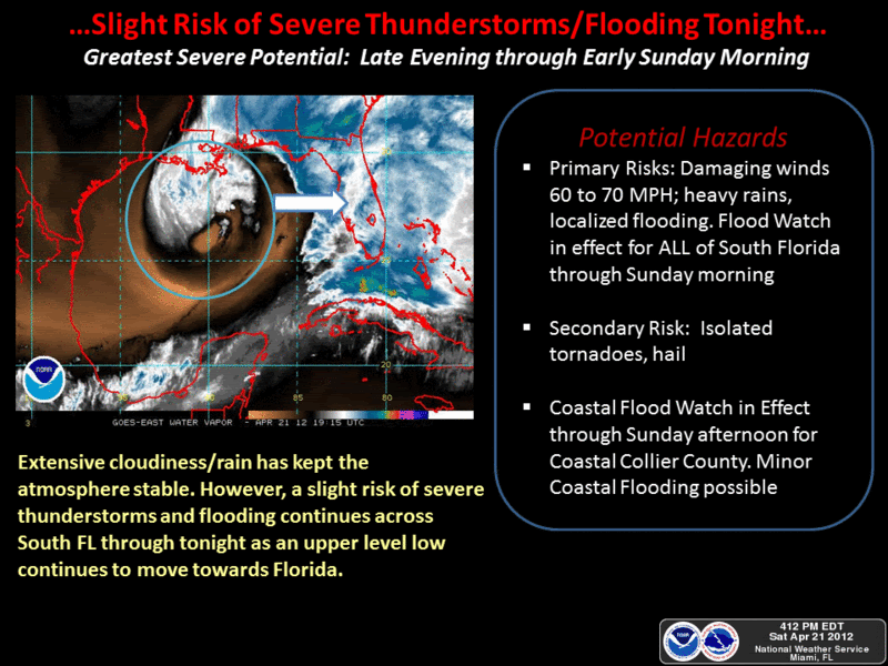
This is the latest graphic posted from the NWS in Miami.
0 likes
The following post is NOT an official forecast and should not be used as such. It is just the opinion of the poster and may or may not be backed by sound meteorological data. It is NOT endorsed by any professional institution including storm2k.org For Official Information please refer to the NHC and NWS products.


Re: Florida Weather
Whoop!!! Got doused! 1-1/2" of verrrrry welcome rain. Hope more is on the way - I feel like being a rain hog today. 
BTW - very cool out right now. I wonder if that will hinder the severe weather later??
BTW - very cool out right now. I wonder if that will hinder the severe weather later??
0 likes

-
AdamFirst

- S2K Supporter
- Posts: 2490
- Age: 36
- Joined: Thu Aug 14, 2008 10:54 am
- Location: Port Saint Lucie, FL
We had some sprinkles from the leading edge of the stratoform blob that was parked over South Florida.
Nothing heavy like they suggested. What happened?
Nothing heavy like they suggested. What happened?
0 likes
Dolphins Marlins Canes Golden Panthers HEAT
Andrew 1992 - Irene 1999 - Frances 2004 - Jeanne 2004 - Wilma 2005 - Fay 2008 - Isaac 2012 - Matthew 2016 - Irma 2017 - Dorian 2019 - Ian 2022 - Nicole 2022 - Milton 2024
Andrew 1992 - Irene 1999 - Frances 2004 - Jeanne 2004 - Wilma 2005 - Fay 2008 - Isaac 2012 - Matthew 2016 - Irma 2017 - Dorian 2019 - Ian 2022 - Nicole 2022 - Milton 2024
-
northjaxpro
- S2K Supporter
- Posts: 8900
- Joined: Mon Sep 27, 2010 11:21 am
- Location: Jacksonville, FL
NWS Jax just issued a severe thunderstorm warning for the southern sections of the Jax metro and areas south in St. Johns and Clay counties. Thunderstorms have been rapidly developing along the St. Johns River moving north.
SEVERE THUNDERSTORM WARNING
NATIONAL WEATHER SERVICE JACKSONVILLE FL
634 PM EDT SAT APR 21 2012
THE NATIONAL WEATHER SERVICE IN JACKSONVILLE HAS ISSUED A
* SEVERE THUNDERSTORM WARNING FOR...
NORTHEASTERN CLAY COUNTY IN NORTHEAST FLORIDA
WESTERN ST. JOHNS COUNTY IN NORTHEAST FLORIDA
SOUTHERN DUVAL COUNTY IN NORTHEAST FLORIDA
* UNTIL 715 PM EDT
* AT 634 PM EDT...NATIONAL WEATHER SERVICE METEOROLOGISTS WERE
TRACKING A SEVERE THUNDERSTORM CAPABLE OF PRODUCING QUARTER SIZE
HAIL...AND DAMAGING WINDS IN EXCESS OF 60 MPH. THIS STORM WAS
LOCATED NEAR GREEN COVE SPRINGS...OR 10 MILES SOUTHWEST OF FRUIT
COVE...AND MOVING NORTH AT 20 MPH.
* OTHER LOCATIONS IN THE WARNING INCLUDE BUT ARE NOT LIMITED TO
SWITZERLAND...FRUIT COVE...DOCTORS INLET...BAYARD...LAKESIDE...
MANDARIN AND ORANGE PARK
0 likes
NEVER, EVER SAY NEVER in the tropics and weather in general, and most importantly, with life itself!!
________________________________________________________________________________________
Fay 2008 Beryl 2012 Debby 2012 Colin 2016 Hermine 2016 Julia 2016 Matthew 2016 Irma 2017 Dorian 2019
________________________________________________________________________________________
Fay 2008 Beryl 2012 Debby 2012 Colin 2016 Hermine 2016 Julia 2016 Matthew 2016 Irma 2017 Dorian 2019
-
northjaxpro
- S2K Supporter
- Posts: 8900
- Joined: Mon Sep 27, 2010 11:21 am
- Location: Jacksonville, FL
HPC initializes the 1001 mb surface Low pressure at 21Z near Panama City.

0 likes
NEVER, EVER SAY NEVER in the tropics and weather in general, and most importantly, with life itself!!
________________________________________________________________________________________
Fay 2008 Beryl 2012 Debby 2012 Colin 2016 Hermine 2016 Julia 2016 Matthew 2016 Irma 2017 Dorian 2019
________________________________________________________________________________________
Fay 2008 Beryl 2012 Debby 2012 Colin 2016 Hermine 2016 Julia 2016 Matthew 2016 Irma 2017 Dorian 2019

Re: Florida Weather
Dry air wrapped in on the eastern side of the low a lot quicker than models were showing, I am afraid that the drought busting rains for a majority of FL will be nothing but a bust. I am glad that I got close to 2" the last couple of days.
0 likes
-
northjaxpro
- S2K Supporter
- Posts: 8900
- Joined: Mon Sep 27, 2010 11:21 am
- Location: Jacksonville, FL
Yeah, that dry slot which has been pronounced on satellite imagery all during the day did indeed get entrained into the Low pressure system NDG. However, I still think another round of rain and storms will come in within the next 6-12 hours across the peninsula.
Also, I am currently absolutely hammered hard by a severe thunderstorm moving in now. Very heavyrain and I just measured a wind gust at 47 mph.
Also, I am currently absolutely hammered hard by a severe thunderstorm moving in now. Very heavyrain and I just measured a wind gust at 47 mph.
Last edited by northjaxpro on Sat Apr 21, 2012 6:17 pm, edited 1 time in total.
0 likes
NEVER, EVER SAY NEVER in the tropics and weather in general, and most importantly, with life itself!!
________________________________________________________________________________________
Fay 2008 Beryl 2012 Debby 2012 Colin 2016 Hermine 2016 Julia 2016 Matthew 2016 Irma 2017 Dorian 2019
________________________________________________________________________________________
Fay 2008 Beryl 2012 Debby 2012 Colin 2016 Hermine 2016 Julia 2016 Matthew 2016 Irma 2017 Dorian 2019
-
otowntiger
- Category 5

- Posts: 1932
- Joined: Tue Aug 31, 2004 7:06 pm
Re: Florida Weather
Another COMPLETE forecast bust for us here in Central Florida!! 
 I got a whopping .04 inches in this big ole rain event that was supposed to make today a washout and bring 2-4 inches of much, much needed rain. They were wrong again.
0 likes
-
AdamFirst
- S2K Supporter
- Posts: 2490
- Age: 36
- Joined: Thu Aug 14, 2008 10:54 am
- Location: Port Saint Lucie, FL
North Florida, Southern Georgia and South Florida got plenty of rain from this event.
Central Florida gets shafted once again. Aside from the squall line overnight I think chances for any big rain are toast.
Central Florida gets shafted once again. Aside from the squall line overnight I think chances for any big rain are toast.
0 likes
Dolphins Marlins Canes Golden Panthers HEAT
Andrew 1992 - Irene 1999 - Frances 2004 - Jeanne 2004 - Wilma 2005 - Fay 2008 - Isaac 2012 - Matthew 2016 - Irma 2017 - Dorian 2019 - Ian 2022 - Nicole 2022 - Milton 2024
Andrew 1992 - Irene 1999 - Frances 2004 - Jeanne 2004 - Wilma 2005 - Fay 2008 - Isaac 2012 - Matthew 2016 - Irma 2017 - Dorian 2019 - Ian 2022 - Nicole 2022 - Milton 2024

YES! MOre rain but not the heavy dousing predicted. Total of 1.4" between Fri eve and today, but that is quite a feat in April. Now they are preciting lower to mid 50's for Mon and Tue nights! That will feel awfully chilly for late April and the coldest we have seen in well over a month. I took off MOnday, so a great day for yard work! 
0 likes
-
northjaxpro
- S2K Supporter
- Posts: 8900
- Joined: Mon Sep 27, 2010 11:21 am
- Location: Jacksonville, FL
Well, a heavy thunderstorm rolled through right over my home location and just over an inch of rain fell. Also had wind gusts at 47 mph when the storm moved over, although I did not see any hail. Happy to get that rain. We can take whatever we can get at this point. The rain has been even heavier just north of me up in SE Georgia as reports of up to 4 inches+ has occurred in the Waycross area.
The surface Low pressure area is approaching the Big Bend region of the peninsula currently. Observing radar and satellite imagery, there is a line of storms that has developed just ahead of the frontal boundary in the extreme Eastern Gulf of Mexico region moving east toward the west coast of the peninsula.
Despite the dry slot which did get entrained into the Low pressure system, the dynamics of this Gulf system are still impressive to provide more lift and energy in the atmosphere to re-fire thunderstorms overnight and into Sunday morning. Although the severe weather potential has substantially decreased, there is still a decent chance that strong thunderstorms will move back into and down the peninsula as the Low moves across North Florida early Sunday. Showers and storms are still quite possible into Sunday morning to develop ahead of the frontal boundary as it pushes down the peninsula late tonight and during the morning hours tomorrow.
0 likes
NEVER, EVER SAY NEVER in the tropics and weather in general, and most importantly, with life itself!!
________________________________________________________________________________________
Fay 2008 Beryl 2012 Debby 2012 Colin 2016 Hermine 2016 Julia 2016 Matthew 2016 Irma 2017 Dorian 2019
________________________________________________________________________________________
Fay 2008 Beryl 2012 Debby 2012 Colin 2016 Hermine 2016 Julia 2016 Matthew 2016 Irma 2017 Dorian 2019
-
AdamFirst
- S2K Supporter
- Posts: 2490
- Age: 36
- Joined: Thu Aug 14, 2008 10:54 am
- Location: Port Saint Lucie, FL
Re: Florida Weather

Pretty potent squall line coming in. Has convection building ahead of it as well.
0 likes
Dolphins Marlins Canes Golden Panthers HEAT
Andrew 1992 - Irene 1999 - Frances 2004 - Jeanne 2004 - Wilma 2005 - Fay 2008 - Isaac 2012 - Matthew 2016 - Irma 2017 - Dorian 2019 - Ian 2022 - Nicole 2022 - Milton 2024
Andrew 1992 - Irene 1999 - Frances 2004 - Jeanne 2004 - Wilma 2005 - Fay 2008 - Isaac 2012 - Matthew 2016 - Irma 2017 - Dorian 2019 - Ian 2022 - Nicole 2022 - Milton 2024
Return to “USA & Caribbean Weather”
Who is online
Users browsing this forum: No registered users and 173 guests