Texas Spring 2012
Moderator: S2k Moderators
Forum rules

The posts in this forum are NOT official forecast and should not be used as such. They are just the opinion of the poster and may or may not be backed by sound meteorological data. They are NOT endorsed by any professional institution or STORM2K.
-
Texas Snowman

- Storm2k Moderator

- Posts: 6197
- Joined: Fri Jan 25, 2008 11:29 am
- Location: Denison, Texas
LOTS of potential for severe weather on Thursday...oh yeah, except for that ridiculously strong cap that will keep it from happening!
0 likes
The above post and any post by Texas Snowman is NOT an official forecast and should not be used as such. It is just the opinion of the poster and may or may not be backed by sound meteorological data. It is NOT endorsed by any professional institution including storm2k.org. For official information, please refer to NWS products.

Re: Texas Spring 2012
I’m a lurker of this site and love reading all of your opinions, but I’m still on the learning curve with much of this. I think I pretty well understand what a cap is and why it prohibits severe weather, but I was wondering what factors are keeping this one in place over Texas? Are there any indications it might dissolve in the near future? Thanks.
0 likes

Re: Texas Spring 2012
lukem wrote:I’m a lurker of this site and love reading all of your opinions, but I’m still on the learning curve with much of this. I think I pretty well understand what a cap is and why it prohibits severe weather, but I was wondering what factors are keeping this one in place over Texas? Are there any indications it might dissolve in the near future? Thanks.
Storms like to track from the SW to NE across the plains. This track pumps up southwesterly flow into Texas and SW of Texas is the Chihuahua Desert (Mexico). This brings warm air above our heads = cap which inhibit thunderstorm initiation. This is quite common with any oncoming storm. In order to break the cap you need 5h vorticity (low pressure winds itself) to travel closer to Texas if not overhead to generate extra lift and out duel the cap.
0 likes
The above post and any post by Ntxw is NOT an official forecast and should not be used as such. It is just the opinion of the poster and may or may not be backed by sound meteorological data. It is NOT endorsed by any professional institution including Storm2k. For official information, please refer to NWS products.
Help support Storm2K!
-
weatherdude1108
- Category 5

- Posts: 4228
- Joined: Tue Dec 13, 2011 1:04 pm
- Location: Northwest Austin/Cedar Park, TX
This has been a depressing April in the thunderstorm/rain department for central Texas. Don't get me wrong, the temperatures in the 50s in the morning to near 80 during the day are great! I would just feel better if there were two inches of rain in the ground prior to it. Here's hoping for a change late next weekend. The 3:11 pm discussion hints at it:
"THE UPPER RIDGE GETS SHOVED EASTWARD BY FRIDAY INTO THE WEEKEND WITH A MORE PROGRESSIVE WESTERLY FLOW THAT WILL RESULT IN DEEPER MOISTURE AND INCREASED RAIN CHANCES LATER IN THE WEEKEND INTO EARLY NEXT WEEK. IN ADDITION A WEAK COLD DROPS INTO CENTRAL TX LATE SATURDAY INTO SUNDAY. STILL SOME UNCERTAINLY ON HOW FAR SOUTHWARD THE FRONT WILL MOVE BEFORE STALLING...AND CONVECTIVE OUTFLOW BOUNDARIES COULD HELP PUSH THE FRONT SOUTHWARD. HAVE CONTINUED SLIGHT CHANCE POPS SATURDAY NIGHT INTO SUNDAY/MONDAY.
LONG RANGE MODEL TRENDS HAVE BEEN CONSISTENT WITH THIS PATTERN...BUT SUSPECT RAIN CHANCES COULD BE MUCH HIGHER IN ANY ONE PERIOD DURING THIS TIME FRAME."
0 likes
The preceding post is NOT an official forecast, and should not be used as such. It is only the opinion of the poster and may or may not be backed by sound meteorological data. It is NOT endorsed by any professional institution including storm2k.org. For Official Information please refer to the NHC and NWS products.
^ Indeed models do indicate a fetch of moisture coming up from the Pacific which can be seen via satellite off the Baja coupled with fronts via NW flow next week. Don't see severe weather parameters yet too early but I suspect it likely won't be just nice good soaking rain for many areas of Texas, hopefully.
0 likes
The above post and any post by Ntxw is NOT an official forecast and should not be used as such. It is just the opinion of the poster and may or may not be backed by sound meteorological data. It is NOT endorsed by any professional institution including Storm2k. For official information, please refer to NWS products.
Help support Storm2K!
Help support Storm2K!
-
horselattitudesfarm

- Category 1

- Posts: 315
- Joined: Thu Jul 16, 2009 5:55 pm
- Location: Asheville, NC (formerly from Dallas, TX)
Re: Texas Spring 2012
Here we go again: Fire weather advisories and diminishing chances of rain.....kinda sounds like last year.
WITH HIGH TEMPERATURES
IN THE 90S AND RELATIVE HUMIDITIES BELOW 30 PERCENT INCREASED FIRE
DANGER IS EXPECTED IN THE WEST...AND A GRASSLAND FIRE
DANGER STATEMENT WILL BE ISSUED.
and,
GFS/ECMWF/CMC ALL CAME IN DRIER THIS WEEKEND INTO NEXT WEEK BECAUSE
THEY NO LONGER SWEEP THE FRONT THROUGH NORTH TEXAS.
INSTEAD...FRONT PUSHES INTO NORTHWESTERN COUNTIES SATURDAY AND
THEN RETREATS NORTH AGAIN SUNDAY AFTERNOON. HAVE LOWERED POPS IN THE
SOUTHEASTERN TWO THIRDS OF NORTH TEXAS AS A RESULT OF THIS CHANGE.
LOWER POPS ALSO EQUATES TO HIGHER TEMPERATURES...AND HAVE PUSHED
HIGHS DURING THE WEEKEND INTO NEXT WEEK UP 5-10 DEGREES.
Is it my misperception or are our April and May's getting drier?
0 likes
^ You're always going to have a fire risk in low humidity and high winds no matter where and when. Difference from last year is we're ahead in rainfall department and everything is green! Fires won't spread or spark as easily compared to one year ago. It has been a dry stretch last week or two but should get wetter next week.
Pretty hot day today in west Texas, if not for the green vegetation many areas of east and north Texas would be going for 100 as well, but fortunately soil moisture is high therefore we'll just make a run at 90ish.
Pretty hot day today in west Texas, if not for the green vegetation many areas of east and north Texas would be going for 100 as well, but fortunately soil moisture is high therefore we'll just make a run at 90ish.
0 likes
The above post and any post by Ntxw is NOT an official forecast and should not be used as such. It is just the opinion of the poster and may or may not be backed by sound meteorological data. It is NOT endorsed by any professional institution including Storm2k. For official information, please refer to NWS products.
Help support Storm2K!
Help support Storm2K!

Re: Texas Spring 2012
What are the thoughts for rain in the DFW area on Saturday? I have seen conflicting predictions all week. I am hosting an outdoor event near downtown Dallas Saturday night and would love to know that it is all clear.
0 likes
Re: Texas Spring 2012
dfw75208 wrote:What are the thoughts for rain in the DFW area on Saturday? I have seen conflicting predictions all week. I am hosting an outdoor event near downtown Dallas Saturday night and would love to know that it is all clear.
You should be fine with plans, warm and sunny most of sat. Evening might pop a stray shower but it is unlikely in the metroplex, closer to the Red River or far SE of the area.
0 likes
The above post and any post by Ntxw is NOT an official forecast and should not be used as such. It is just the opinion of the poster and may or may not be backed by sound meteorological data. It is NOT endorsed by any professional institution including Storm2k. For official information, please refer to NWS products.
Help support Storm2K!
Help support Storm2K!
-
horselattitudesfarm
- Category 1
- Posts: 315
- Joined: Thu Jul 16, 2009 5:55 pm
- Location: Asheville, NC (formerly from Dallas, TX)
Re:
Ntxw wrote:^ You're always going to have a fire risk in low humidity and high winds no matter where and when. Difference from last year is we're ahead in rainfall department and everything is green! Fires won't spread or spark as easily compared to one year ago. It has been a dry stretch last week or two but should get wetter next week.
Pretty hot day today in west Texas, if not for the green vegetation many areas of east and north Texas would be going for 100 as well, but fortunately soil moisture is high therefore we'll just make a run at 90ish.
Better enjoy the green while it lasts. Like a skipping record it goes like this: Persistent SW flow aloft and a stubborn cap make for little to no precipitation chances for at least the next week. This is only April folks: April and May are supposed to be our wettest months. There are holes where places haven't had rain since April 1rst (our area included) and lakes are already starting to drop when they should be refilling (Lake Travis for one). Records for heat are already being broken in West Texas (and I mean all time highs for the whole month of April!) Texas is being left in the dust again (pun intended) and I watch as storm systems are taking left-handed turns and going through Oklahoma and Kansas. (Quote from Accuweather: "Similar to Thursday's setup, warm and humid air surging northward out of Texas and into the southern Plains will clash with cool air to the north in the northern Plains This will create a battle zone over Kansas and Missouri this afternoon into tonight as an area of low pressure ejects out of the Rockies and into the High Plains".)
Lets all sit back and watch the Drought Monitor accumulate D2+ totals for our state as we wonder where we are going to get our water from come August.......of course.......our beloved Gulf of America could finally start doing her share of the work and start providing some tropical activity this summer and save us. Let us hope. Anyway, this is more emotional than I usually get but I just can't stand the thought of Texas burning up through yet one more summer and the possibility that this is the new normal for our state.
0 likes

0 likes
-
horselattitudesfarm
- Category 1
- Posts: 315
- Joined: Thu Jul 16, 2009 5:55 pm
- Location: Asheville, NC (formerly from Dallas, TX)
Re: Texas Spring 2012
As reinforcement for my previous tyrade: From the NOAA Texas Forecast Discussion for San Antonio I give you:
"DISCUSSION...
00Z MODELS SIMILAR WITH RESPECT TO SOUTH CENTRAL TEXAS TODAY
THROUGH NEXT WEEK WITH EVEN LESS CHANCE FOR RAIN. AN UPPER LEVEL
TROUGH MOVING INTO THE CENTRAL PLAINS EARLY THIS MORNING HAS
FLATTENED THE UPPER LEVEL RIDGE SOMEWHAT. A WEST TO SOUTHWEST FLOW
ALOFT HAS DEVELOPED OVER TEXAS. TODAY WILL BE SLIGHTLY "COOLER"
THAN LAST COUPLE OF DAYS AS LOWER LEVEL FLOW TURNS MORE SOUTHERLY
WITH LESS OF AN INFLUENCE OF THE FLOW OFF THE MEXICAN PLATEAU.
HIGHS WILL STILL RANGE FROM THE UPPER 80S EAST TO THE UPPER 90S
WEST. LOWER LEVEL MOISTURE DOES DEEPEN A LITTLE THIS WEEKEND INTO
NEXT WEEK WHILE A FEW WEAK SHORT-WAVES MOVE ALONG THE UPPER LEVEL
FLOW. HOWEVER...A STRONG MID LEVEL CAP WILL INHIBIT ANY
CONVECTION...EXCEPT OVER THE SERRANIAS DEL BURRO AND ALONG THE
DRYLINE. IT IS POSSIBLE THAT SOME OF THESE MAY BE STEERED INTO
WESTERN AREAS SUNDAY AND MONDAY EVENINGS. FURTHER EAST...THERE MAY
BE SOME EARLY MORNING DRIZZLE. BY THE MIDDLE TO LATE PART OF NEXT
WEEK...THE MODELS SHOW SIGNS OF THE UPPER LEVEL RIDGE REBUILDING
OVER SOUTHERN TEXAS. HAVE GONE A LITTLE WARMER THAN HIGH
TEMPERATURE GUIDANCE AS NAM MODEL TEMPERATURES HAVE DONE WELL THIS
SPRING AND HAVE TRENDED TOWARD THEM FOR TODAY THROUGH SUNDAY. FOR
THE REMAINDER...HAVE GONE NEAR THE ECMWF HIRES BIAS CORRECTED".
I especially like the "Have gone a little warmer than high temperature guidance..." part as high temp guidance is already hot .
Anyway, I guess there isn't a need to beat a dead horse stuck in the Horselattitudes region any longer.
0 likes
-
weatherdude1108
- Category 5
- Posts: 4228
- Joined: Tue Dec 13, 2011 1:04 pm
- Location: Northwest Austin/Cedar Park, TX
Re: Texas Spring 2012
horselattitudesfarm wrote:As reinforcement for my previous tyrade: From the NOAA Texas Forecast Discussion for San Antonio I give you:
"DISCUSSION...
00Z MODELS SIMILAR WITH RESPECT TO SOUTH CENTRAL TEXAS TODAY
THROUGH NEXT WEEK WITH EVEN LESS CHANCE FOR RAIN. AN UPPER LEVEL
TROUGH MOVING INTO THE CENTRAL PLAINS EARLY THIS MORNING HAS
FLATTENED THE UPPER LEVEL RIDGE SOMEWHAT. A WEST TO SOUTHWEST FLOW
ALOFT HAS DEVELOPED OVER TEXAS. TODAY WILL BE SLIGHTLY "COOLER"
THAN LAST COUPLE OF DAYS AS LOWER LEVEL FLOW TURNS MORE SOUTHERLY
WITH LESS OF AN INFLUENCE OF THE FLOW OFF THE MEXICAN PLATEAU.
HIGHS WILL STILL RANGE FROM THE UPPER 80S EAST TO THE UPPER 90S
WEST. LOWER LEVEL MOISTURE DOES DEEPEN A LITTLE THIS WEEKEND INTO
NEXT WEEK WHILE A FEW WEAK SHORT-WAVES MOVE ALONG THE UPPER LEVEL
FLOW. HOWEVER...A STRONG MID LEVEL CAP WILL INHIBIT ANY
CONVECTION...EXCEPT OVER THE SERRANIAS DEL BURRO AND ALONG THE
DRYLINE. IT IS POSSIBLE THAT SOME OF THESE MAY BE STEERED INTO
WESTERN AREAS SUNDAY AND MONDAY EVENINGS. FURTHER EAST...THERE MAY
BE SOME EARLY MORNING DRIZZLE. BY THE MIDDLE TO LATE PART OF NEXT
WEEK...THE MODELS SHOW SIGNS OF THE UPPER LEVEL RIDGE REBUILDING
OVER SOUTHERN TEXAS. HAVE GONE A LITTLE WARMER THAN HIGH
TEMPERATURE GUIDANCE AS NAM MODEL TEMPERATURES HAVE DONE WELL THIS
SPRING AND HAVE TRENDED TOWARD THEM FOR TODAY THROUGH SUNDAY. FOR
THE REMAINDER...HAVE GONE NEAR THE ECMWF HIRES BIAS CORRECTED".
I especially like the "Have gone a little warmer than high temperature guidance..." part as high temp guidance is already hot .
Anyway, I guess there isn't a need to beat a dead horse stuck in the Horselattitudes region any longer.
Yeah, I am getting emotional about this as well.
The Climate Prediction Center's 6-10 and 8-14 day had a forecast for normal to above normal rainfall in this area yesterday. Today it is below normal for both periods. Tomorrow it may be back to normal. I don't know. Crapshoot. I don't even bother with the temperature predictions at this point.
http://www.cpc.ncep.noaa.gov/products/p ... day.02.gif
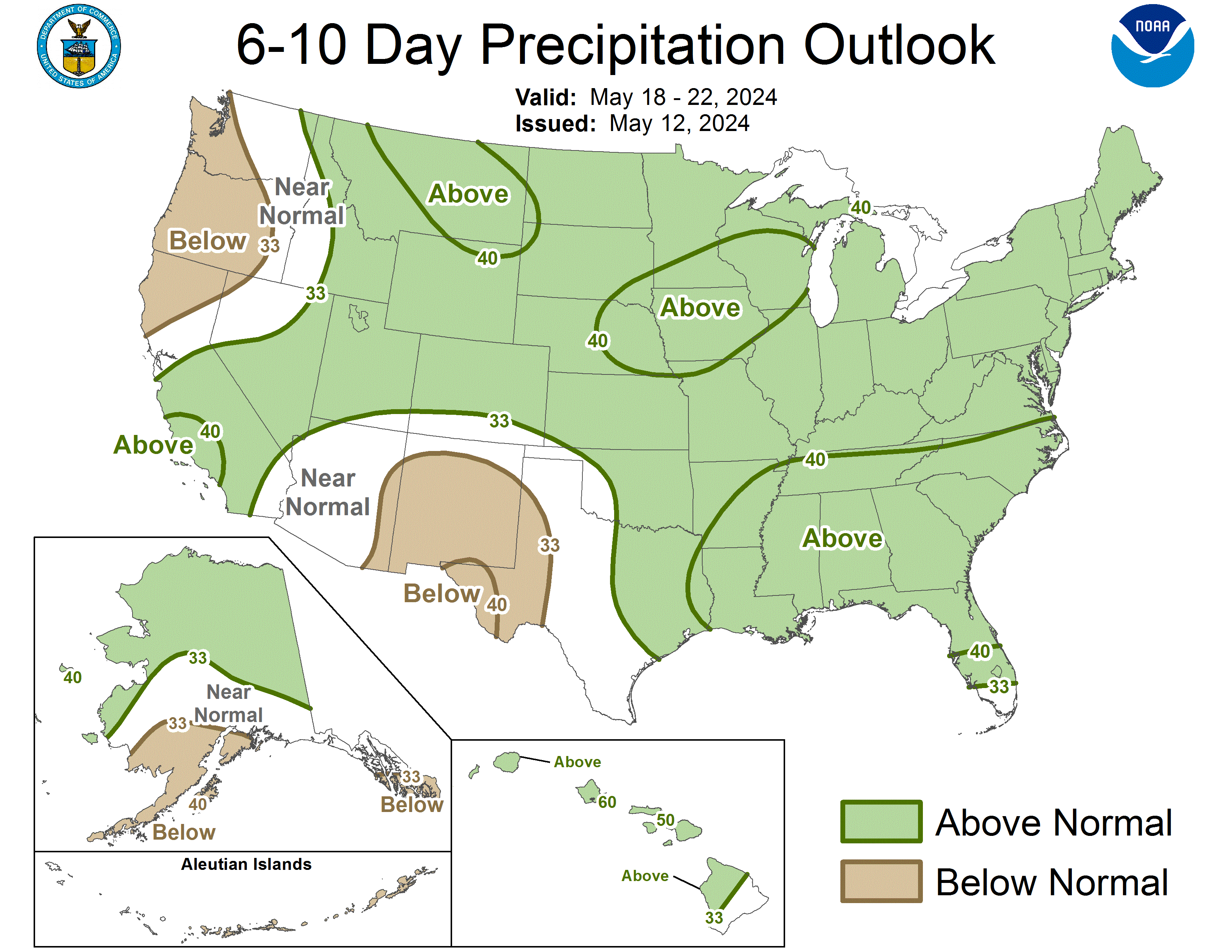
http://www.cpc.ncep.noaa.gov/products/p ... day.02.gif
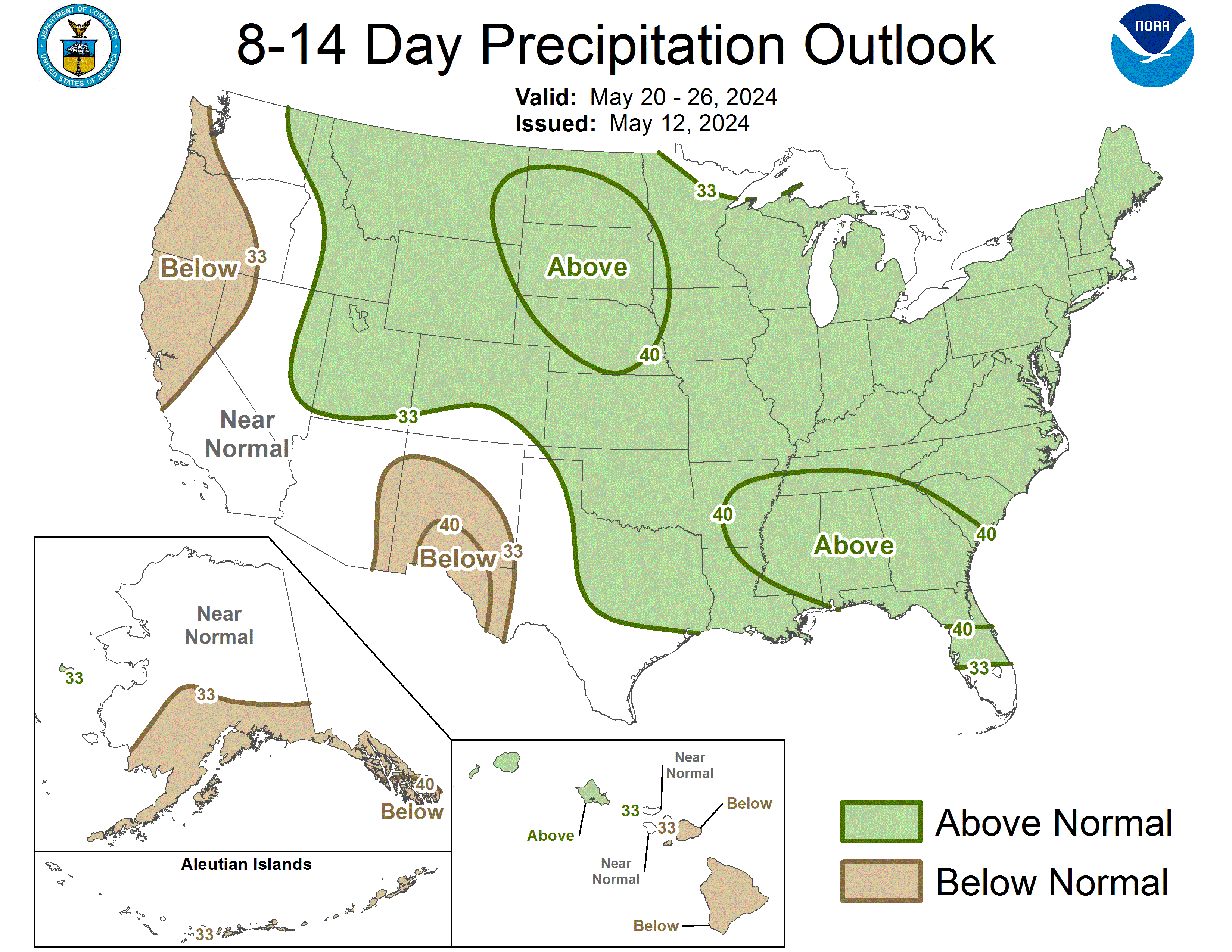
0 likes
The preceding post is NOT an official forecast, and should not be used as such. It is only the opinion of the poster and may or may not be backed by sound meteorological data. It is NOT endorsed by any professional institution including storm2k.org. For Official Information please refer to the NHC and NWS products.
-
Texas Snowman
- Storm2k Moderator
- Posts: 6197
- Joined: Fri Jan 25, 2008 11:29 am
- Location: Denison, Texas
Not time to panic yet (albeit, I'm in a part of the state that is lush, green, and has lakes and ponds that are totally full).
As others (including Ntxw) have pointed out, atmosphere set-up is different at this point than it was a year ago. Nothing that I've seen so far would indicate we're in for an extreme summer like 2011.
Not saying it can't happen, just not evident at this point. Ntxw has pointed out that the E-PAC tropical season may be robust with the developing El Nino and if so, that can have a huge impact on our weather.
0 likes
The above post and any post by Texas Snowman is NOT an official forecast and should not be used as such. It is just the opinion of the poster and may or may not be backed by sound meteorological data. It is NOT endorsed by any professional institution including storm2k.org. For official information, please refer to NWS products.
-
Texas Snowman
- Storm2k Moderator
- Posts: 6197
- Joined: Fri Jan 25, 2008 11:29 am
- Location: Denison, Texas
Not saying you guys have, but sometimes I think many in Texas forget that your average garden variety summer in Texas is HOT, HOT, HOT nine out of 10 times.
And it's usually going to be pretty dry with some occasional bouts of storms.
2007 was a HUGE exception to that rule with flooding rains in North Texas in June and July (we had a flash flood drowning death here in the Sherman/Denison area where I live and nearby Lake Texoma went over its spillway that summer for only the third time ever).
Tropics are always a wild card.
0 likes
The above post and any post by Texas Snowman is NOT an official forecast and should not be used as such. It is just the opinion of the poster and may or may not be backed by sound meteorological data. It is NOT endorsed by any professional institution including storm2k.org. For official information, please refer to NWS products.
-
Texas Snowman
- Storm2k Moderator
- Posts: 6197
- Joined: Fri Jan 25, 2008 11:29 am
- Location: Denison, Texas
BTW, noticed this from Fort Worth NWS in their forecast discussion. Maybe a little hope for rainfall late next week?
----
OTHERWISE MODELS ARE NOT YET IN GOOD AGREEMENT ON WHEN AND WHERE A
WEAK UPPER LEVEL LOW OFF OF BAJA EARLY NEXT WEEK WILL TRACK. ECMWF
SUGGESTS RAIN CHANCES WILL BE BACK BY FRIDAY...BUT OTHER MODELS
HOLD THE LOW OUT TO SEA A LITTLE LONGER. WILL KEEP THE EXTENDED
FORECAST DRY FOR NOW.
----
OTHERWISE MODELS ARE NOT YET IN GOOD AGREEMENT ON WHEN AND WHERE A
WEAK UPPER LEVEL LOW OFF OF BAJA EARLY NEXT WEEK WILL TRACK. ECMWF
SUGGESTS RAIN CHANCES WILL BE BACK BY FRIDAY...BUT OTHER MODELS
HOLD THE LOW OUT TO SEA A LITTLE LONGER. WILL KEEP THE EXTENDED
FORECAST DRY FOR NOW.
0 likes
The above post and any post by Texas Snowman is NOT an official forecast and should not be used as such. It is just the opinion of the poster and may or may not be backed by sound meteorological data. It is NOT endorsed by any professional institution including storm2k.org. For official information, please refer to NWS products.
I must admit it has been dry since early month. But I have faith the duration of HEAT like last year will not happen. DFW has forecasted to hit 90 and over several times this week but did not happen (almost May and have yet to hit). I credit this due to previous mentioned reasons. It's not crazy that west texas gets superhot they are still in drought and parts of central Texas as well. It's not going to be wet all of the time as Texas Snowman mentioned.
By this time last year we were already pushing 100 and extreme drought has already set foot in SE TX. I like to look there as indication for NTX since our moisture source often times pass them on it's way here. It will get hot but I bet it won't be of duration as one year ago.
By this time last year we were already pushing 100 and extreme drought has already set foot in SE TX. I like to look there as indication for NTX since our moisture source often times pass them on it's way here. It will get hot but I bet it won't be of duration as one year ago.
0 likes
The above post and any post by Ntxw is NOT an official forecast and should not be used as such. It is just the opinion of the poster and may or may not be backed by sound meteorological data. It is NOT endorsed by any professional institution including Storm2k. For official information, please refer to NWS products.
Help support Storm2K!
Help support Storm2K!
-
Texas Snowman
- Storm2k Moderator
- Posts: 6197
- Joined: Fri Jan 25, 2008 11:29 am
- Location: Denison, Texas
Working off memory here, but if I remember, April and May 2007 were a bit on the warm and dry side (I'm a big deer hunter, always pay attention to rainfall here in spring and early summer because of the impact it has on antler development).
Was kind of worried heading into June.
Then the heavens opened up in June and July. Texoma shot up, went over the spillway.
So the jury is still out on what will happen in Texas in late spring and early summer.
Was kind of worried heading into June.
Then the heavens opened up in June and July. Texoma shot up, went over the spillway.
So the jury is still out on what will happen in Texas in late spring and early summer.
0 likes
The above post and any post by Texas Snowman is NOT an official forecast and should not be used as such. It is just the opinion of the poster and may or may not be backed by sound meteorological data. It is NOT endorsed by any professional institution including storm2k.org. For official information, please refer to NWS products.
-
horselattitudesfarm
- Category 1
- Posts: 315
- Joined: Thu Jul 16, 2009 5:55 pm
- Location: Asheville, NC (formerly from Dallas, TX)
Re: Texas Spring 2012
thanks for the above posts-of-hope..... I'm feelin' a little better. I sure would like to see that big spike in the Lake Travis lake level on the USGS website sometime this summer. At least if it holds off until late June they won't be releasing all that precious water to the rice farmers downstream like they did last year. Maybe I won't have to see all those dead pine trees down around Houston again this year either. I remember back in the good ole days when we had normal springs driving down to Houston seeing all those white dogwood blooms under an emerald green forest canopy with deep lush grass along the sides of the highway. Maybe I'll get to see that happen again someday. 
0 likes
-
horselattitudesfarm
- Category 1
- Posts: 315
- Joined: Thu Jul 16, 2009 5:55 pm
- Location: Asheville, NC (formerly from Dallas, TX)
Found the following in Texas Climate News about water issues this spring:
Water cutoff to rice farmers typifies contentious issues confronting Texas
The Lower Colorado River Authority’s decision to deprive downstream rice farmers of water – for the first time ever – was an especially dramatic example of the historic Texas drought’s continuing impact, even as unexpected winter rains have mitigated its severity somewhat.
The LCRA action, triggered by an emergency drought policy that had been negotiated by the farmers and other stakeholders in the river basin, is hardly the only recent development that illustrates how Texans are increasingly grappling with the prospect that lingering dry conditions will only multiply and aggravate always-contentious issues about how to manage the state’s water supply.
Climate experts have been warning – regardless of whether current drought conditions drag on for years, as some have said may happen – that manmade climate change promises to bring hotter, drier conditions to Texas in decades ahead as a growing population places greater demands on water resources.
Rice farmers in Wharton, Colorado and Matagorda counties will be affected by the decision not to release water from Lakes Buchanan and Travis in Central Texas – an irrigation supply they always received in the past when conditions were too dry for them to take water directly from the river. The Associated Press reported recently that rice cultivation in the three counties usually represents 35 to 45 percent of the Texas rice crop, about five percent of the nation’s rice production.
Besides downstream farmers, the lakes managed by LCRA provide water for more than a million people in Central Texas and industries in the basin. The agency explained the action impacting the rice industry in an announcement on Friday:
The historic decision became official at 11:59 p.m. Thursday, March 1, when the combined storage of the lakes failed to reach 850,000 acre-feet. That was the level agreed upon last September by LCRA and stakeholders throughout the basin, including downstream farmers, when they negotiated the emergency drought relief measures that the Texas Commission on Environmental Quality approved in December. The highest combined storage on March 1 was 847,324 acre-feet at 11:59 p.m.
“This is the first time in history that downstream farmers will not receive all the water they need from LCRA,” General Manager Becky Motal said. “This was a difficult decision by LCRA and the stakeholders, but one that was made with the best interest of the entire basin in mind. This current drought is one of the most severe on record, and the responses to the drought need to be on the same level.”
Even with the recent rains, lakes Buchanan and Travis are only 42 percent full. The combined storage of the lakes Friday was about 847,000 acre-feet. Because storage was less than 850,000 acre-feet on March 1, farmers in the Lakeside, Gulf Coast and Pierce Ranch irrigation operations will not receive any water from the Highland Lakes this year
There is more to the article that can be found at:
http://texasclimatenews.org/wp/?p=4499
0 likes
Return to “USA & Caribbean Weather”
Who is online
Users browsing this forum: South Texas Storms and 301 guests