The weak surface Low just to the southwest of Key West this afternoon and the High Pressure ridge across the SE US is generating a pretty good pressure gradient across the Keys and the southeast tip of the peninsula. Easterly winds are now gusting to near or just over tropical storm force in some spots. The Miami NWS office reported a wind gust of 35 mph on their 2:pm observation and Virginia Key had a wind gust last hour at 43 mph.
--------------------
NWS Miami statement excerpt at 1:58 pm
REGIONAL OBSERVATIONS INDICATE A SURFACE LOW ACROSS THE FLORIDA
STRAITS TO THE SOUTHWEST OF KEY WEST THAT HAS ENHANCED THE LOCAL
PRESSURE GRADIENT SIGNIFICANTLY WITH EASTERLY FLOW NEAR 20 KNOTS
TO GUSTS TO NEAR 30 KNOTS FOR THE EAST COAST TAF SITES EXPECTED TO
CONTINUE THROUGH 00Z TUESDAY AND COULD REMAIN AT THAT STRENGTH INTO
TUESDAY MORNING. THE LOW PRESSURE SYSTEM WILL MAINTAIN DEEP
TROPICAL MOISTURE ACROSS THE REGION THROUGH THIS EVENING AND WILL
LIKELY CONTINUE INTO TUESDAY MORNING...
Florida Weather
Moderator: S2k Moderators
Forum rules

The posts in this forum are NOT official forecast and should not be used as such. They are just the opinion of the poster and may or may not be backed by sound meteorological data. They are NOT endorsed by any professional institution or STORM2K.
-
northjaxpro

- S2K Supporter

- Posts: 8900
- Joined: Mon Sep 27, 2010 11:21 am
- Location: Jacksonville, FL
-
cycloneye

- Admin

- Posts: 149161
- Age: 69
- Joined: Thu Oct 10, 2002 10:54 am
- Location: San Juan, Puerto Rico
Re: Florida Weather

0 likes
Visit the Caribbean-Central America Weather Thread where you can find at first post web cams,radars
and observations from Caribbean basin members Click Here
and observations from Caribbean basin members Click Here
-
AdamFirst

- S2K Supporter
- Posts: 2490
- Age: 36
- Joined: Thu Aug 14, 2008 10:54 am
- Location: Port Saint Lucie, FL
Unsettled pattern expected for this upcoming week.
Which probably means big blue skies and sunshine for east central Florida.
Which probably means big blue skies and sunshine for east central Florida.
MON-MON NIGHT...A WEAK AREA OF LOW PRESSURE WILL LIE OFF OF THE
EAST CENTRAL FLORIDA COAST DURING THE DAY WITH ASSOCIATED...BUT HARD
TO DISCERN...SURFACE BOUNDARY STREWN OVER THE NORTH-CENTRAL
PENINSULA. THIS WILL ALLOW SLIGHTLY DEEPER MOISTURE TO POOL ACROSS
THE FORECAST AREA. AN UPPER-TROUGH PATTERN WILL EXIST OVERHEAD WITH
ASSOCIATED COLD POOL AT 500 MB (-12C). THE PRESSURE GRADIENT WILL
REMAIN LIGHT WITH SOME FORM OF SEA BREEZE/MESOSCALE BOUNDARY
COLLISIONS DURING THE AFTERNOON RESULTING IN SCATTERED SHOWERS AND
THUNDERSTORMS. A FEW STORMS COULD BE ON THE STRONG SIDE. HIGHS A
LITTLE COOLER ON THIS DAY AND ALSO EXPECT A BIT MORE CLOUD COVER.
AFTERNOON MAXES GENERALLY IN THE MIDDLE TO UPPER 80S...BUT CANNOT
RULE OUT ISOLATED READINGS NEAR 90 DEGREES ACROSS PORTIONS OF THE
INTERIOR. LOWS GENERALLY IN THE 60S.
TUE-FRI...(PREVIOUSLY EXTENDED FORECAST)...UNSETTLED WX IN STORE FOR
CENTRAL FL. CURRENT POSITION H25 JET SUGGESTS THE BULK OF ITS ENERGY
WILL REMAIN ON THE ASCENDING SIDE OF A SHORT WAVE TROF OVER THE WRN
CONUS. WX PATTERN OVER THE CONUS WILL AMPLIFY AS THE TROF DEEPENS ON
ITS EWD TREK...ALLOWING AN OMEGA TYPE BLOCKING PATTERN TO EVOLVE.
FRONTAL TROF WILL REMAIN STALLED OVER THE AREA THRU MIDWEEK...
KEEPING THE MOISTURE POOL OVER THE REGION. SCT PRECIP CHANCES FOR
CENTRAL FL THRU THE FIRST PART OF NEXT WEEK.
EXTENDED MOS GUIDANCE AS COME INTO BETTER AGREEMENT OVER THE PAST
24HRS...THOUGH OVERALL NUMBERS REMAIN BLO 50PCT. CHC AFTN/EVNG TSRAS
THRU MIDWEEK...SLIGHTLY HIGHER OVER THE NRN CWA DUE TO DEEPER
MOISTURE. MAX TEMPS IN THE L/M80S (NEAR AVG)...MIN TEMPS U60S-L70S
(4-8F ABV AVG).
0 likes
Dolphins Marlins Canes Golden Panthers HEAT
Andrew 1992 - Irene 1999 - Frances 2004 - Jeanne 2004 - Wilma 2005 - Fay 2008 - Isaac 2012 - Matthew 2016 - Irma 2017 - Dorian 2019 - Ian 2022 - Nicole 2022 - Milton 2024
Andrew 1992 - Irene 1999 - Frances 2004 - Jeanne 2004 - Wilma 2005 - Fay 2008 - Isaac 2012 - Matthew 2016 - Irma 2017 - Dorian 2019 - Ian 2022 - Nicole 2022 - Milton 2024
-
Hurricaneman

- Category 5

- Posts: 7404
- Age: 45
- Joined: Tue Aug 31, 2004 3:24 pm
- Location: central florida

-
Rgv20

- S2K Supporter
- Posts: 2466
- Age: 39
- Joined: Wed Jan 05, 2011 5:42 pm
- Location: Edinburg/McAllen Tx
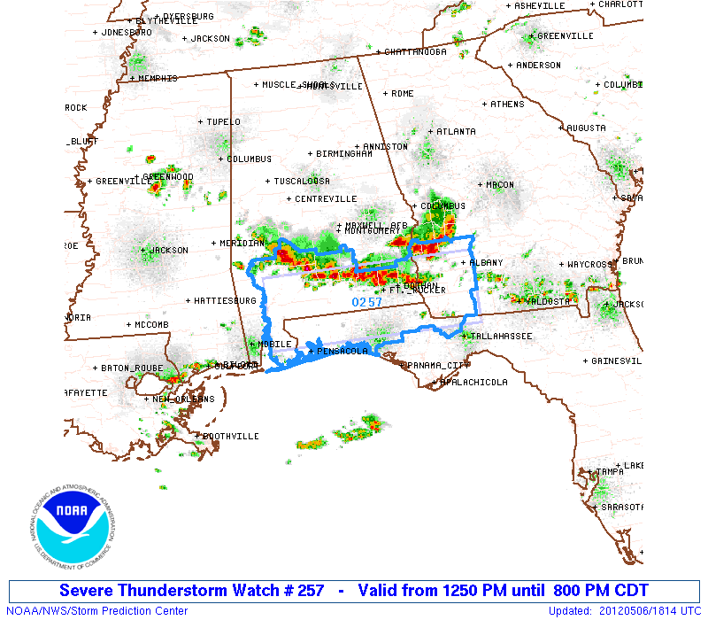
Parts of the Panhandle of Florida is in a Severe Thunderstorm Watch including the Pensacola area.
URGENT - IMMEDIATE BROADCAST REQUESTED
SEVERE THUNDERSTORM WATCH NUMBER 257
NWS STORM PREDICTION CENTER NORMAN OK
1250 PM CDT SUN MAY 6 2012
THE NWS STORM PREDICTION CENTER HAS ISSUED A
SEVERE THUNDERSTORM WATCH FOR PORTIONS OF
SOUTHERN ALABAMA
FLORIDA PANHANDLE
SOUTHWEST GEORGIA
EFFECTIVE THIS SUNDAY AFTERNOON AND EVENING FROM 1250 PM UNTIL
800 PM CDT.
HAIL TO 1.5 INCHES IN DIAMETER...THUNDERSTORM WIND GUSTS TO 70
MPH...AND DANGEROUS LIGHTNING ARE POSSIBLE IN THESE AREAS.
THE SEVERE THUNDERSTORM WATCH AREA IS APPROXIMATELY ALONG AND 40
STATUTE MILES NORTH AND SOUTH OF A LINE FROM 55 MILES WEST
SOUTHWEST OF EVERGREEN ALABAMA TO 30 MILES SOUTH SOUTHEAST OF
ALBANY GEORGIA. FOR A COMPLETE DEPICTION OF THE WATCH SEE THE
ASSOCIATED WATCH OUTLINE UPDATE (WOUS64 KWNS WOU7).
REMEMBER...A SEVERE THUNDERSTORM WATCH MEANS CONDITIONS ARE
FAVORABLE FOR SEVERE THUNDERSTORMS IN AND CLOSE TO THE WATCH
AREA. PERSONS IN THESE AREAS SHOULD BE ON THE LOOKOUT FOR
THREATENING WEATHER CONDITIONS AND LISTEN FOR LATER STATEMENTS
AND POSSIBLE WARNINGS. SEVERE THUNDERSTORMS CAN AND OCCASIONALLY
DO PRODUCE TORNADOES.
OTHER WATCH INFORMATION...CONTINUE...WW 255...WW 256...
DISCUSSION...TSTMS ARE ORGANIZING THIS AFTERNOON IN AN ARC FROM
W-CNTRL AL TO SWRN GA WITH ACTIVITY FOCUSED ALONG A SWD-MOVING COLD
POOL. AMBIENT AIR MASS HAS BECOME MODERATELY UNSTABLE OWING TO THE
PRESENCE OF A MOIST BOUNDARY LAYER AND SEASONABLY COOL MIDLEVEL
TEMPERATURES. WHILE VERTICAL SHEAR WILL REMAIN WEAK...THE CHARACTER
OF THE THERMODYNAMIC ENVIRONMENT WILL FOSTER HAIL PRODUCTION AND
DAMAGING WINDS WITH THE MOST INTENSE STORMS.
AVIATION...A FEW SEVERE THUNDERSTORMS WITH HAIL SURFACE AND ALOFT
TO 1.5 INCHES. EXTREME TURBULENCE AND SURFACE WIND GUSTS TO 60
KNOTS. A FEW CUMULONIMBI WITH MAXIMUM TOPS TO 500. MEAN STORM
MOTION VECTOR 36020.
...MEAD
0 likes
The following post is NOT an official forecast and should not be used as such. It is just the opinion of the poster and may or may not be backed by sound meteorological data. It is NOT endorsed by any professional institution including storm2k.org For Official Information please refer to the NHC and NWS products.
-
cycloneye
- Admin
- Posts: 149161
- Age: 69
- Joined: Thu Oct 10, 2002 10:54 am
- Location: San Juan, Puerto Rico
Re: Florida Weather
Here is the summer rainy season outlook by NOAA. It looks like a more wet summer than in 2011 is instored.
http://www.srh.noaa.gov/images/mfl/news ... ok2012.pdf
http://www.srh.noaa.gov/images/mfl/news ... ok2012.pdf
0 likes
Visit the Caribbean-Central America Weather Thread where you can find at first post web cams,radars
and observations from Caribbean basin members Click Here
and observations from Caribbean basin members Click Here
-
northjaxpro
- S2K Supporter
- Posts: 8900
- Joined: Mon Sep 27, 2010 11:21 am
- Location: Jacksonville, FL

Last edited by northjaxpro on Tue May 08, 2012 2:21 pm, edited 1 time in total.
0 likes
NEVER, EVER SAY NEVER in the tropics and weather in general, and most importantly, with life itself!!
________________________________________________________________________________________
Fay 2008 Beryl 2012 Debby 2012 Colin 2016 Hermine 2016 Julia 2016 Matthew 2016 Irma 2017 Dorian 2019
________________________________________________________________________________________
Fay 2008 Beryl 2012 Debby 2012 Colin 2016 Hermine 2016 Julia 2016 Matthew 2016 Irma 2017 Dorian 2019
-
MidnightRain

- Tropical Storm

- Posts: 110
- Joined: Tue Oct 11, 2011 8:26 pm
- Location: NW Florida
Re: Florida Weather
Line of storms now approaching us from the north up here in the panhandle, nice timing too as we were about to get into the 90's haha.


0 likes
The posts in this forum are NOT official forecast and should not be used as such. They are just the opinion of the poster and may or may not be backed by sound meteorological data. They are NOT endorsed by any professional institution or storm2k.org. For official information, please refer to the NHC and NWS products.

Nice pics MidnightRain, that disturbance along I-10 sent a ripple effect in the atmosphere down the peninsula this afternoon as a couple of thunderstorms were able to pop through here in the Orlando area, I have not gotten any rain but at least an outflow out of it has cooled me down to the low 80s after highs in the low to mid 90s.
Looks like a better chance of afternoon thunderstorms across interior central FL over the next couple of days.
Looks like a better chance of afternoon thunderstorms across interior central FL over the next couple of days.
0 likes
-
northjaxpro
- S2K Supporter
- Posts: 8900
- Joined: Mon Sep 27, 2010 11:21 am
- Location: Jacksonville, FL
Latest water vapor imagery showed an upper level shortwave moving currently along the South Carolina coast near Charleston. Looking at the radar on this page, it is beginning to light up. Spokes of energy rotating south around the upper shortwave into the moist and unstable air mass across the region is firing plenty of showers and thunderstorms this afternoon. Hopefully we will get a good dousing of rain this afternoon and evening across the northeast Florida peninsula. Some of these cells may reach severe levels with small hail and strong winds.
Yesterday, I received a bit over 6/10 of an inch of rainfall. Definitely need much more and hopefully over the next few days, we can put a serious dent into the drought conditions for sure.
Yesterday, I received a bit over 6/10 of an inch of rainfall. Definitely need much more and hopefully over the next few days, we can put a serious dent into the drought conditions for sure.
0 likes
NEVER, EVER SAY NEVER in the tropics and weather in general, and most importantly, with life itself!!
________________________________________________________________________________________
Fay 2008 Beryl 2012 Debby 2012 Colin 2016 Hermine 2016 Julia 2016 Matthew 2016 Irma 2017 Dorian 2019
________________________________________________________________________________________
Fay 2008 Beryl 2012 Debby 2012 Colin 2016 Hermine 2016 Julia 2016 Matthew 2016 Irma 2017 Dorian 2019
-
vbhoutex

- Storm2k Executive
- Posts: 29143
- Age: 74
- Joined: Wed Oct 09, 2002 11:31 pm
- Location: Cypress, TX
- Contact:
Re:
gsytch wrote:Nothing but clear, sunny skies and a nice seabreeze here. No rain in 16 days. Afternoons nearer 90F but again, good breezes. Rain, rain o' where are thou?
Sounds a lot like SE TX. Hope our forecasted rain for this week comes to fruition. Hope you guys get some too.
0 likes
Skywarn, C.E.R.T.
Please click below to donate to STORM2K to help with the expenses of keeping the site going:

Please click below to donate to STORM2K to help with the expenses of keeping the site going:
Almost looks like the beginning of our rainy season, for at least those of us at eastern & interior central FL. 
We got the heat and we got the humidity, seabreeze collisions & UL disturbances are helping to spark the atmosphere.
I got over an inch and a half with some areas close to me nearly 3"

We got the heat and we got the humidity, seabreeze collisions & UL disturbances are helping to spark the atmosphere.
I got over an inch and a half with some areas close to me nearly 3"
0 likes
-
gatorcane

- S2K Supporter
- Posts: 23708
- Age: 48
- Joined: Sun Mar 13, 2005 3:54 pm
- Location: Boca Raton, FL
Re: Florida Weather
I think the rainy season may have started for South Florida. Another round of seabreeze driven storms developed today and reading the disco there are good rain chances through the week....and even still over the weekend, but not as high. Here is a good article to read not just on the rainy season but large-scale weather patterns and some global model predictions for the next several months. Enjoy:
http://www.srh.noaa.gov/images/mfl/news ... ok2012.pdf
http://www.srh.noaa.gov/images/mfl/news ... ok2012.pdf
0 likes
-
cycloneye
- Admin
- Posts: 149161
- Age: 69
- Joined: Thu Oct 10, 2002 10:54 am
- Location: San Juan, Puerto Rico
Re: Florida Weather
gatorcane wrote:I think the rainy season may have started for South Florida. Another round of seabreeze driven storms developed today and reading the disco there are good rain chances through the week....and even still over the weekend, but not as high. Here is a good article to read not just on the rainy season but large-scale weather patterns and some global model predictions for the next several months. Enjoy:
http://www.srh.noaa.gov/images/mfl/news ... ok2012.pdf
I posted that same link eight posts above,but that's ok.
0 likes
Visit the Caribbean-Central America Weather Thread where you can find at first post web cams,radars
and observations from Caribbean basin members Click Here
and observations from Caribbean basin members Click Here


-
AdamFirst
- S2K Supporter
- Posts: 2490
- Age: 36
- Joined: Thu Aug 14, 2008 10:54 am
- Location: Port Saint Lucie, FL
Re: Florida Weather
Right on top of me
BULLETIN - EAS ACTIVATION REQUESTED
SEVERE THUNDERSTORM WARNING
NATIONAL WEATHER SERVICE MELBOURNE FL
335 PM EDT TUE MAY 8 2012
THE NATIONAL WEATHER SERVICE IN MELBOURNE HAS ISSUED A
* SEVERE THUNDERSTORM WARNING FOR...
NORTHEASTERN MARTIN COUNTY IN FLORIDA
SOUTHEASTERN ST. LUCIE COUNTY IN FLORIDA
* UNTIL 430 PM EDT.
* AT 330 PM EDT...NATIONAL WEATHER SERVICE METEOROLOGISTS DETECTED A
SEVERE THUNDERSTORM CAPABLE OF PRODUCING QUARTER SIZE HAIL...AND
DAMAGING WINDS IN EXCESS OF 60 MPH. THIS STORM WAS LOCATED NEAR
PORT SAINT LUCIE RIVER PARK...OR NEAR PORT SAINT LUCIE...AND MOVING
EAST AT 10 MPH.
* OTHER LOCATIONS IN THE WARNING INCLUDE...BUT ARE NOT LIMITED TO...
INDIAN RIVER ESTATES...SAINT LUCIE NUCLEAR PLANT...NORTH RIVER
SHORES...WALTON...NETTLES ISLAND AND JENSEN BEACH
0 likes
Dolphins Marlins Canes Golden Panthers HEAT
Andrew 1992 - Irene 1999 - Frances 2004 - Jeanne 2004 - Wilma 2005 - Fay 2008 - Isaac 2012 - Matthew 2016 - Irma 2017 - Dorian 2019 - Ian 2022 - Nicole 2022 - Milton 2024
Andrew 1992 - Irene 1999 - Frances 2004 - Jeanne 2004 - Wilma 2005 - Fay 2008 - Isaac 2012 - Matthew 2016 - Irma 2017 - Dorian 2019 - Ian 2022 - Nicole 2022 - Milton 2024
-
AdamFirst
- S2K Supporter
- Posts: 2490
- Age: 36
- Joined: Thu Aug 14, 2008 10:54 am
- Location: Port Saint Lucie, FL
Re: Florida Weather


0 likes
Dolphins Marlins Canes Golden Panthers HEAT
Andrew 1992 - Irene 1999 - Frances 2004 - Jeanne 2004 - Wilma 2005 - Fay 2008 - Isaac 2012 - Matthew 2016 - Irma 2017 - Dorian 2019 - Ian 2022 - Nicole 2022 - Milton 2024
Andrew 1992 - Irene 1999 - Frances 2004 - Jeanne 2004 - Wilma 2005 - Fay 2008 - Isaac 2012 - Matthew 2016 - Irma 2017 - Dorian 2019 - Ian 2022 - Nicole 2022 - Milton 2024

Return to “USA & Caribbean Weather”
Who is online
Users browsing this forum: No registered users and 275 guests