


Texas Spring 2012
Moderator: S2k Moderators
Forum rules

The posts in this forum are NOT official forecast and should not be used as such. They are just the opinion of the poster and may or may not be backed by sound meteorological data. They are NOT endorsed by any professional institution or STORM2K.
Re: Texas Spring 2012
0 likes
The above post and any post by Ntxw is NOT an official forecast and should not be used as such. It is just the opinion of the poster and may or may not be backed by sound meteorological data. It is NOT endorsed by any professional institution including Storm2k. For official information, please refer to NWS products.
Help support Storm2K!
-
Rgv20

- S2K Supporter

- Posts: 2466
- Age: 39
- Joined: Wed Jan 05, 2011 5:42 pm
- Location: Edinburg/McAllen Tx
TORNADO WARNING
TXC047-247-427-082115-
/O.NEW.KBRO.TO.W.0013.120508T2052Z-120508T2115Z/
BULLETIN - EAS ACTIVATION REQUESTED
TORNADO WARNING
NATIONAL WEATHER SERVICE BROWNSVILLE TX
352 PM CDT TUE MAY 8 2012
THE NATIONAL WEATHER SERVICE IN BROWNSVILLE HAS ISSUED A
* TORNADO WARNING FOR...
WESTERN BROOKS COUNTY IN DEEP SOUTH TEXAS.
SOUTHEASTERN JIM HOGG COUNTY IN DEEP SOUTH TEXAS.
NORTHEASTERN STARR COUNTY IN DEEP SOUTH TEXAS.
* UNTIL 415 PM CDT
* AT 352 PM CDT...NATIONAL WEATHER SERVICE METEOROLOGISTS DETECTED
A SEVERE THUNDERSTORM CAPABLE OF PRODUCING A TORNADO JUST WEST
OF AGUA NUEVA...MOVING EAST AT 40 MPH.
* THE TORNADO WILL BE NEAR...
AGUA NUEVA BY 355 PM CDT.
PRECAUTIONARY/PREPAREDNESS ACTIONS...
THIS IS A DANGEROUS STORM! MOVE INTO THE INTERIOR ROOM ON THE LOWEST
FLOOR OF A STURDY BUILDING...AWAY FROM WINDOWS. COVER YOUR HEAD AND
BODY WITH PILLOWS OR BLANKETS.
PLEASE REPORT TORNADOES OR FUNNEL CLOUDS...WINDS OF 58 MPH OR
HIGHER...HAIL THE SIZE OF PENNIES OR LARGER...AND ANY WIND DAMAGE TO
YOUR NATIONAL WEATHER SERVICE IN BROWNSVILLE BY CALLING 956-504-1432.
&&
LAT...LON 2702 9827 2678 9832 2675 9833 2683 9875
2703 9874
TIME...MOT...LOC 2052Z 272DEG 36KT 2692 9863
$$
0 likes
The following post is NOT an official forecast and should not be used as such. It is just the opinion of the poster and may or may not be backed by sound meteorological data. It is NOT endorsed by any professional institution including storm2k.org For Official Information please refer to the NHC and NWS products.
-
Rgv20
- S2K Supporter
- Posts: 2466
- Age: 39
- Joined: Wed Jan 05, 2011 5:42 pm
- Location: Edinburg/McAllen Tx
Hope the 3 day forecast rainfall from the HPC verifies!
Forecast valid from Tuesday 6pm to Friday 7pm.

Forecast valid from Tuesday 6pm to Friday 7pm.
0 likes
The following post is NOT an official forecast and should not be used as such. It is just the opinion of the poster and may or may not be backed by sound meteorological data. It is NOT endorsed by any professional institution including storm2k.org For Official Information please refer to the NHC and NWS products.
-
weatherdude1108
- Category 5

- Posts: 4228
- Joined: Tue Dec 13, 2011 1:04 pm
- Location: Northwest Austin/Cedar Park, TX
Re: Texas Spring 2012
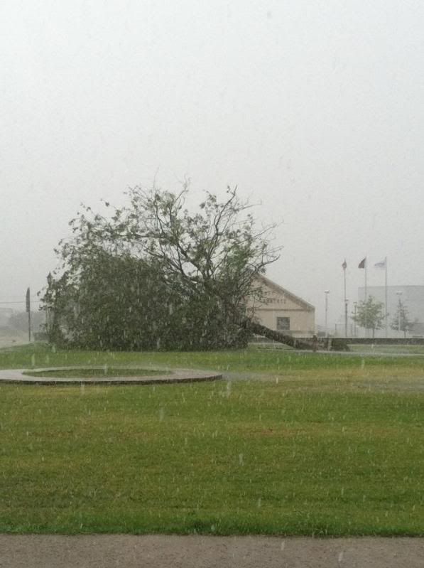
Shoshana wrote:We were at The Avengers and didn't hear anything but came home to a fence down, half the stuff on the patio in the yard, the kiddie pool (that was under other furniture) nowhere to be seen and a totally freaked out dog.....
It was windy in southern Williamson Co. at my house. Tree branches down all up and down our street. Water leaked under front door as the rain slammed against the front side of house. Got a little scary. They said on the news there was confirmed 50-60 mph straight-line winds in North Austin. We got 1.6 inches in our gauge!
0 likes
The preceding post is NOT an official forecast, and should not be used as such. It is only the opinion of the poster and may or may not be backed by sound meteorological data. It is NOT endorsed by any professional institution including storm2k.org. For Official Information please refer to the NHC and NWS products.
Re: Texas Spring 2012
Portastorm wrote:Shoshana wrote:We were at The Avengers and didn't hear anything but came home to a fence down, half the stuff on the patio in the yard, the kiddie pool (that was under other furniture) nowhere to be seen and a totally freaked out dog.....
Shoshana, your area of Austin got it the worst last night. Hail and high winds impacted north Austin into Pflugerville. In fact, a funnel cloud was spotted around 8 p.m. near Wells Branch. So ... I'm not surprised to see your report. It wasn't much down in south Austin as it spit rain for a bit and that was it. We did have some wind gusts.
We were at the Cinemark Tinseltown on 35 pretty much where Austin meets Pflugerville. We missed the whole thing - 7:05 showtime. We got out and saw everything was wet and never knew how bad it was till we got home and saw the back yard and the claw marks the pup left in the door and frame of the room she was in. My friends texted me about the funnel cloud! We had a metal trash can with 40lbs+ of potting soil in it on top of the kiddie pool and the can got knocked off the pool! I'm just glad the grill didn't go flying! We keep it tucked against the house.
weatherdude1108 wrote:Shoshana wrote:We were at The Avengers and didn't hear anything but came home to a fence down, half the stuff on the patio in the yard, the kiddie pool (that was under other furniture) nowhere to be seen and a totally freaked out dog.....
It was windy in southern Williamson Co. at my house. Tree branches down all up and down our street. Water leaked under front door as the rain slammed against the front side of house. Got a little scary. They said on the news there was confirmed 50-60 mph straight-line winds in North Austin. We got 1.6 inches in our gauge!Just light rain today. I have video of the storm, just not sure how to post it here(?).
I think my gauge blew away. I have to go look tomorrow! I am really surprised we didn't have any trees down - we have hackberries that usually fall if someone sneezes. I think if you upload your video to youtube you can link to it here.
0 likes

Re: Texas Spring 2012
Shoshana wrote:We were at The Avengers and didn't hear anything but came home to a fence down, half the stuff on the patio in the yard, the kiddie pool (that was under other furniture) nowhere to be seen and a totally freaked out dog.....
I think the serious weather was kind of spotty. Here where we are on the edge of Pflugerville next to Round Rock I never knew there was a funnel cloud only a couple of miles away, we had no high winds or hail, very little rain, only lots of thunder and lightning.
0 likes
Any opinions stated are those of an amateur, please take with several grains of salt and for official forecast refer to the National Weather Service.
-
Rgv20
- S2K Supporter
- Posts: 2466
- Age: 39
- Joined: Wed Jan 05, 2011 5:42 pm
- Location: Edinburg/McAllen Tx
More Severe Weather is expected for my area thru the week..
Special Weather Statement
SPECIAL WEATHER STATEMENT
NATIONAL WEATHER SERVICE BROWNSVILLE TX
323 AM CDT WED MAY 9 2012
TXZ248>257-091700-
ZAPATA-JIM HOGG-BROOKS-KENEDY-STARR-HIDALGO-INLAND WILLACY-
INLAND CAMERON-COASTAL WILLACY-COASTAL CAMERON-
INCLUDING THE CITIES OF...ZAPATA...HEBBRONVILLE...FALFURRIAS...
SARITA...RIO GRANDE CITY...ROMA...MCALLEN...EDINBURG...PHARR...
MISSION...WESLACO...RAYMONDVILLE...BROWNSVILLE...HARLINGEN...
PORT MANSFIELD...PORT ISABEL...SOUTH PADRE ISLAND...
LAGUNA HEIGHTS...LAGUNA VISTA
323 AM CDT WED MAY 9 2012
...MORE SEVERE WEATHER POSSIBLE THIS AFTERNOON THROUGH FRIDAY...
THE DEVELOPMENT OF ADDITIONAL SHOWERS AND THUNDERSTORMS IS EXPECTED
THIS AFTERNOON AND EVENING ACROSS THE RIO GRANDE VALLEY AND DEEP
SOUTH TEXAS. AS TEMPERATURES INCREASE THE INSTABILITY ACROSS THE
AREA IS EXPECTED TO BECOME STRONG ENOUGH TO ALLOW FOR THE
DEVELOPMENT OF A FEW SEVERE THUNDERSTORMS WITH DAMAGING WINDS OF
ABOUT 60 MPH...AND HAIL TO AROUND QUARTER SIZE...WITH A FEW STORMS
POSSIBLY PRODUCING HAIL TO AROUND TWO INCHES IN DIAMETER. THE MOST
LIKELY TIME FOR SEVERE WEATHER WILL BE AFTER 4 PM...AND BEFORE
MIDNIGHT WEDNESDAY. VERY HEAVY RAIN WILL ALSO BE POSSIBLE WHERE
THUNDERSTORMS DEVELOP. IF IT IS ESPECIALLY CLOUDY DURING THE DAY
WEDNESDAY...THAT WILL LIKELY WORK TO LIMIT THUNDERSTORM POTENTIAL IN
THE AFTERNOON AND EVENING.
MORE ORGANIZED SEVERE WEATHER IS POSSIBLE THURSDAY AFTERNOON AND
OVERNIGHT AS A POWERFUL LOW PRESSURE SYSTEM APPROACHES FROM THE
NORTHWEST. THE CURRENT FORECAST CALLS FOR A BETTER CHANCE OF LARGE
HAIL...DAMAGING WINDS...AND ISOLATED TORNADOES. THE MOST LIKELY TIME
FOR SEVERE WEATHER IS BETWEEN 3 PM THURSDAY AND 6 AM FRIDAY.
MORE INFORMATION WILL BE AVAILABLE AS THE EVENT NEARS AND FORECASTS
WILL BE UPDATED ACCORDINGLY. CHECK WEATHER.GOV/RGV...AND MONITOR
NOAA WEATHER RADIO AND LOCAL MEDIA FOR LATER STATEMENTS...UPDATED
FORECASTS...AND POSSIBLE WARNINGS.
0 likes
The following post is NOT an official forecast and should not be used as such. It is just the opinion of the poster and may or may not be backed by sound meteorological data. It is NOT endorsed by any professional institution including storm2k.org For Official Information please refer to the NHC and NWS products.
Re: Texas Spring 2012
ndale wrote:Shoshana wrote:We were at The Avengers and didn't hear anything but came home to a fence down, half the stuff on the patio in the yard, the kiddie pool (that was under other furniture) nowhere to be seen and a totally freaked out dog.....
I think the serious weather was kind of spotty. Here where we are on the edge of Pflugerville next to Round Rock I never knew there was a funnel cloud only a couple of miles away, we had no high winds or hail, very little rain, only lots of thunder and lightning.
I didn't see any evidence of hail. On the other hand, our fence and my ol blue car already have little hail pockmarks from previous storms...
My rain gauge is gone ... somewhere. I think my husband pulled it out of the ground to mow and set it on the patio ... and there's no telling where it is so I don't know how far it flew...
As far as rain, it's been dry enough that rain is soaking right into the ground so it's hard to tell how much it rained without a gauge.
We're south of you - on the edge of Austin next to Pflugerville.
Rgv20 - stay safe! Today it's sunny here but tomorrow and Fri it's supposed to possibly be stormy yet again.
0 likes
-
Rgv20
- S2K Supporter
- Posts: 2466
- Age: 39
- Joined: Wed Jan 05, 2011 5:42 pm
- Location: Edinburg/McAllen Tx
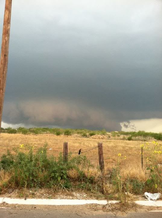
This photos are courtesy of the NWS in Brownsville..
This is in Zapata, Tx yesterday!
PRELIMINARY LOCAL STORM REPORT...SUMMARY
NATIONAL WEATHER SERVICE BROWNSVILLE TX
1138 AM CDT WED MAY 09 2012
..TIME... ...EVENT... ...CITY LOCATION... ...LAT.LON...
..DATE... ....MAG.... ..COUNTY LOCATION..ST.. ...SOURCE....
..REMARKS..
1200 PM TSTM WND DMG SAN YGNACIO 27.03N 99.45W
05/08/2012 ZAPATA TX EMERGENCY MNGR
THREE TO FOUR HOMES WITH ROOF DAMAGE IN SAN YGNACIO AS
WELL AS ONE MOBILE HOME DESTROYED.
1200 PM TSTM WND GST SAN YGNACIO 27.03N 99.45W
05/08/2012 E65 MPH ZAPATA TX EMERGENCY MNGR
ZAPATA COUNTY EMERGENCY MANAGER REPORTS THUNDERSTORM
WIND GUSTS OF 60 TO 65 MPH OCCURRED IN SAN YGNACIO.
1211 PM HEAVY RAIN SAN YGNACIO 27.03N 99.45W
05/08/2012 E1.00 INCH ZAPATA TX TRAINED SPOTTER
1235 PM TSTM WND GST ZAPATA 26.89N 99.26W
05/08/2012 M62 MPH ZAPATA TX AWOS
0103 PM TSTM WND DMG ZAPATA 26.89N 99.26W
05/08/2012 ZAPATA TX PUBLIC
SEVERAL TREES DOWN AROUND 4 INCHES IN DIAMETER AT 4TH
AND FLORES STREETS IN ZAPATA.
0323 PM HAIL ZAPATA 26.89N 99.26W
05/08/2012 E1.00 INCH ZAPATA TX PUBLIC
QUARTER SIZE HAIL REPORTED AT LINCOLN AND 5TH STREET.
0326 PM TSTM WND GST ZAPATA 26.89N 99.26W
05/08/2012 E60 MPH ZAPATA TX PUBLIC
WIND GUSTS ESTIMATED 60 TO 65 MPH AT LINCOLN AND 5TH
STREET.
0335 PM FLASH FLOOD ZAPATA 26.89N 99.26W
05/08/2012 U0.00 INCH ZAPATA TX LAW ENFORCEMENT
STREET FLOODING WITH BRIEFLY UP TO 3 FEET OF MOVING
WATER NEAR INTERSECTION OF IRENE AND US 83.
0510 PM TSTM WND DMG 6 N SAN MANUEL 26.66N 98.11W
05/08/2012 HIDALGO TX LAW ENFORCEMENT
*** 1 INJ *** SEMI TRAILER BLOWN OVER ON US 281 6 MILES
NORTH OF TX HWY 186.
0510 PM DOWNBURST 6 N SAN MANUEL 26.66N 98.12W
05/08/2012 E80 MPH HIDALGO TX COUNTY OFFICIAL
CONSTABLE REPORTED HOME LOST NUMEROUS SHIGLES... ONE
WINDOW BLOWN OUT... LARGE MESQUITE AND EBONY TREE
BRANCHES SNAPPED
0515 PM FUNNEL CLOUD ELSA 26.30N 97.99W
05/08/2012 HIDALGO TX PUBLIC
FUNNEL CLOUD REPORTED ON HWY 107 NEAR ELSA AT CORNER OF
CURVE AND DOOLITTLE.
0605 PM TSTM WND GST RAYMONDVILLE 26.48N 97.78W
05/08/2012 E60 MPH WILLACY TX EMERGENCY MNGR
WILLACY COUNTY EMERGENCY MANAGER REPORTS 50 TO 60 MPH
WINDS OCCURRED IN RAYMONDVILLE.
0 likes
The following post is NOT an official forecast and should not be used as such. It is just the opinion of the poster and may or may not be backed by sound meteorological data. It is NOT endorsed by any professional institution including storm2k.org For Official Information please refer to the NHC and NWS products.
-
weatherdude1108
- Category 5
- Posts: 4228
- Joined: Tue Dec 13, 2011 1:04 pm
- Location: Northwest Austin/Cedar Park, TX
Hope the area lakes see another rise! Would be great news! Don't want loss of life or property in the process though. Thought I'd add that caveat. 
NWS Austin/San Antonio
"Previous discussion... /issued 347 PM CDT Wednesday may 9 2012/ .Widespread heavy rain and flash flooding possible late Thursday through early Friday... Discussion... the upper level low across northern Mexico/southern Arizona/southern nm will progress eastward overnight. Showers and thunderstorms have already begun to develop across West Texas in advance of the system...and also beginning to see convection fire off of the serranias del burro in northestern Mexico. Expect convective activity to persist through the evening hours and gradually spread eastward overnight. Rain chances will continue to increase on Thursday as the upper low moves into The Big Bend region. Showers and thunderstorms will become widespread by Thursday evening and continue through Friday morning as the low moves across central Texas before tapering off from the west Friday evening. There is a slight risk for severe storms Thursday afternoon and evening across areas generally along and southwest of a line from del Rio to San Antonio to Karnes City. The main threats are large hail and damaging winds. Some showers and thunderstorms may linger across far eastern portions on Saturday but otherwise expect much of the activity to push into East Texas as the low becomes an open wave across the Arkansas/la/TX region. In addition to the prolonged period of high chances for rain...area precipitable water values are running at about 2 Standard deviations above normal (ie very wet)...so locally heavy rain is expected. Have issued a Flash Flood Watch for Thursday evening until noon on Friday. Current thinking is that there could be locally heavy rainfall as early as tonight...and potentially isolated minor flooding issues due to runoff...but widespread heavy rain is not expected until later in the day on Thursday. Models are still generating quantitative precipitation forecast bulls-eyes here and there across the state...but going with a combination of HPC quantitative precipitation forecast guidance and a rough average of the models...expect storm total rainfall (tonight through early Saturday morning) to average 2 to 4 inches with isolated totals over 4 inches. Once the rain clears out on Saturday...a drier weekend is in store. Middle/long-range models have come to better agreement with the potential for a northwest flow event sometime in the late Monday/Tuesday time frame. Given the run-to-run consistency of this feature over the last few days...have kept mention of probability of precipitation for Monday and Tuesday and will fine-tune as we get closer. Bias-corrected consensus temperatures are generally on track...but have decreased the diurnal temperature range for the rainy periods. Highs through the weekend will be at least a few degrees cooler than average for early/middle may due to the combination of cloud cover and rain. A slow warming trend is expected early next week. Hydrology... periods of rain...heavy at times...are expected Wednesday night through early Saturday. Due to already moistened soils from rainfall earlier this week...rainfall will be quick to runoff and may cause minor flooding of creeks and streams across south central Texas and The Hill Country. Low water crossings may become impassible. Showers and thunderstorms will end from west to east late Friday...with only scattered activity across the eastern portions of the region by Saturday afternoon."
0 likes
The preceding post is NOT an official forecast, and should not be used as such. It is only the opinion of the poster and may or may not be backed by sound meteorological data. It is NOT endorsed by any professional institution including storm2k.org. For Official Information please refer to the NHC and NWS products.
-
weatherdude1108
- Category 5
- Posts: 4228
- Joined: Tue Dec 13, 2011 1:04 pm
- Location: Northwest Austin/Cedar Park, TX
Saw this blurb:
"Hydrology... with large areas of 1-3 inch rains expected...all creek and river basins in south central Texas will have the potential to see significant rises. Some of these rises could cut off secondary roadways for several hours. However...most main Stem river flows are currently below historical norms...which should help reduce the potential for main-Stem river flooding to reach major levels."
Area forecast discussion National Weather Service Austin/San Antonio Texas 412 am CDT Thursday may 10 2012 Discussion... large cut-off low over northern Mexico will produce a heavy rain event over a good portion of Texas today into Friday. Model trends are pointing toward a track slightly farther to the north than was projected from Wednesday. This trend spread the heavy rain potential northward and spreads the focus for convection over a broader area...limiting the threat that heavy rains will concentrate over any one particular area. Will continue to mention widespread 1 to 2 rainfall amounts with isolated totals in excess of 4 inches. Mesoscale model runs collectively project a round of heavy rains to move NE across our western counties into central and north-central Texas during the day today...with an mesoscale convective system forming farther south and covering our southern counties in the evening and overnight hours. This scenario would support a fairly even distribution of the rain potential across the area...with northern areas possibly seeing multiple rounds of heavy downpours...and southern counties having a higher potential for intense thunderstorms tonight. The more northerly track of the upper low allows for more convection to feed off southeast winds off the Gulf...enhancing the severe weather potential over the southern counties. With a better chance for breaks in the cloud cover to the south...afternoon and early evening should help enhance this threat. The Storm Prediction Center slight risk area covers areas southwest of a Mountain Home to New Braunfels to Hallettsville line where severe cells and isolated supercells could take advantage of heating...shear...and steep middle level lapse rates. By late tonight...a well-developed mesoscale convective system is expected to steer the more intense thunderstorm cells to the southeast with broad areas of moderate to heavy rain to fill in behind the leading edge. Thus quantitative precipitation forecast values are more conservative for the daytime hours Friday. Cool air on the backside of the upper low and wrap-around cloudiness should promote cool conditions into Saturday with a few thunderstorms remaining possible. A progressive flow pattern aloft projects more clouds and instability to approach the area by Tuesday with the 00z GFS leading the way in projecting another significant rain event for Tuesday. The more conservative European model (ecmwf) shows more consistency...so will keep probability of precipitation slight and continue mild may temperatures. && Hydrology... with large areas of 1-3 inch rains expected...all creek and river basins in south central Texas will have the potential to see significant rises. Some of these rises could cut off secondary roadways for several hours. However...most main Stem river flows are currently below historical norms...which should help reduce the potential for main-Stem river flooding to reach major levels.
0 likes
The preceding post is NOT an official forecast, and should not be used as such. It is only the opinion of the poster and may or may not be backed by sound meteorological data. It is NOT endorsed by any professional institution including storm2k.org. For Official Information please refer to the NHC and NWS products.
-
Rgv20
- S2K Supporter
- Posts: 2466
- Age: 39
- Joined: Wed Jan 05, 2011 5:42 pm
- Location: Edinburg/McAllen Tx
A possible Tornado Watch coming soon for parts of Texas! Main threat looks to be Large Hail tho!
URGENT - IMMEDIATE BROADCAST REQUESTED
SEVERE THUNDERSTORM WATCH NUMBER 270
NWS STORM PREDICTION CENTER NORMAN OK
545 AM CDT THU MAY 10 2012
THE NWS STORM PREDICTION CENTER HAS ISSUED A
SEVERE THUNDERSTORM WATCH FOR PORTIONS OF
SOUTH CENTRAL AND DEEP SOUTH TEXAS
COASTAL WATERS
EFFECTIVE THIS THURSDAY MORNING AND AFTERNOON FROM 545 AM UNTIL
100 PM CDT.
HAIL TO 2 INCHES IN DIAMETER...THUNDERSTORM WIND GUSTS TO 70
MPH...AND DANGEROUS LIGHTNING ARE POSSIBLE IN THESE AREAS.
THE SEVERE THUNDERSTORM WATCH AREA IS APPROXIMATELY ALONG AND 70
STATUTE MILES EAST AND WEST OF A LINE FROM 45 MILES WEST
NORTHWEST OF JUNCTION TEXAS TO 5 MILES WEST SOUTHWEST OF
BROWNSVILLE TEXAS. FOR A COMPLETE DEPICTION OF THE WATCH SEE THE
ASSOCIATED WATCH OUTLINE UPDATE (WOUS64 KWNS WOU0).
REMEMBER...A SEVERE THUNDERSTORM WATCH MEANS CONDITIONS ARE
FAVORABLE FOR SEVERE THUNDERSTORMS IN AND CLOSE TO THE WATCH
AREA. PERSONS IN THESE AREAS SHOULD BE ON THE LOOKOUT FOR
THREATENING WEATHER CONDITIONS AND LISTEN FOR LATER STATEMENTS
AND POSSIBLE WARNINGS. SEVERE THUNDERSTORMS CAN AND OCCASIONALLY
DO PRODUCE TORNADOES.
DISCUSSION...ELEVATED TSTMS...INCLUDING A FEW SUPERCELLS... EXPECTED
TO INCREASE IN COVERAGE OVER THE LWR RIO GRANDE VLY OF TX THROUGH
MIDDAY AS WAA...LOW LVL MOISTURE TRANSPORT...AND UPR DIVERGENCE
INCREASE DOWNSTREAM FROM UPR LOW NOW APPROACHING FROM N CNTRL
MEXICO. DEEP WIND PROFILES...ALREADY ADEQUATE FOR SUPERCELLS...WILL
STRENGTHEN LATER THIS MORNING. COUPLED WITH QUALITY OF MOIST INFLOW
/PW 1.25-1.75 INCHES/ AND THE LIKELIHOOD THAT UPDRAFTS WILL BECOME
MORE NEARLY SFC-BASED WITH TIME...SRN AND PERHAPS CNTRL PARTS OF THE
WATCH MAY REQUIRE UPGRADE TO TORNADO LATER THIS MORNING.
AVIATION...A FEW SEVERE THUNDERSTORMS WITH HAIL SURFACE AND ALOFT
TO 2 INCHES. EXTREME TURBULENCE AND SURFACE WIND GUSTS TO 60
KNOTS. A FEW CUMULONIMBI WITH MAXIMUM TOPS TO 550. MEAN STORM
MOTION VECTOR 24020.
...CORFIDI
0 likes
The following post is NOT an official forecast and should not be used as such. It is just the opinion of the poster and may or may not be backed by sound meteorological data. It is NOT endorsed by any professional institution including storm2k.org For Official Information please refer to the NHC and NWS products.
-
Rgv20
- S2K Supporter
- Posts: 2466
- Age: 39
- Joined: Wed Jan 05, 2011 5:42 pm
- Location: Edinburg/McAllen Tx
Tornado Watch
TORNADO WATCH OUTLINE UPDATE FOR WT 271
NWS STORM PREDICTION CENTER NORMAN OK
1140 AM CDT THU MAY 10 2012
TORNADO WATCH 271 IS IN EFFECT UNTIL 800 PM CDT FOR THE
FOLLOWING LOCATIONS
TXC007-013-025-047-057-061-123-127-131-163-175-215-247-249-255-
261-273-283-297-311-323-355-391-409-427-469-479-489-493-505-507-
110100-
/O.NEW.KWNS.TO.A.0271.120510T1640Z-120511T0100Z/
TX
. TEXAS COUNTIES INCLUDED ARE
ARANSAS ATASCOSA BEE
BROOKS CALHOUN CAMERON
DEWITT DIMMIT DUVAL
FRIO GOLIAD HIDALGO
JIM HOGG JIM WELLS KARNES
KENEDY KLEBERG LA SALLE
LIVE OAK MAVERICK MCMULLEN
NUECES REFUGIO SAN PATRICIO
STARR VICTORIA WEBB
WILLACY WILSON ZAPATA
ZAVALA
$$
0 likes
The following post is NOT an official forecast and should not be used as such. It is just the opinion of the poster and may or may not be backed by sound meteorological data. It is NOT endorsed by any professional institution including storm2k.org For Official Information please refer to the NHC and NWS products.
Mesoanalysis from the spc site does look conducive for isolated tornadoes today in deep south Texas locally. The way the upper low is set up ripes that region with plenty of instability and change of winds above the surface. Stay safe RGV and everyone else down there.

0 likes
The above post and any post by Ntxw is NOT an official forecast and should not be used as such. It is just the opinion of the poster and may or may not be backed by sound meteorological data. It is NOT endorsed by any professional institution including Storm2k. For official information, please refer to NWS products.
Help support Storm2K!
Help support Storm2K!
-
cctxhurricanewatcher

- Category 5
- Posts: 1206
- Joined: Sun Sep 12, 2004 8:53 pm
- Location: Corpus Christi, Texas
Re: Texas Spring 2012
Looks like this afternoon is going to be "fun."
Strange, strange spring down this way with the hail, tornadoes..... Please no hurricanes this summer!
0 likes
Here we go south Texas.
SEVERE WEATHER STATEMENT
NATIONAL WEATHER SERVICE CORPUS CHRISTI TX
134 PM CDT THU MAY 10 2012
TXC273-355-101845-
/O.CON.KCRP.TO.W.0019.000000T0000Z-120510T1845Z/
KLEBERG-NUECES-
134 PM CDT THU MAY 10 2012
...A TORNADO WARNING REMAINS IN EFFECT UNTIL 145 PM CDT FOR SOUTH
CENTRAL NUECES AND NORTH CENTRAL KLEBERG COUNTIES...
AT 132 PM CDT...TRAINED WEATHER SPOTTERS REPORTED A FUNNEL CLOUD 15
MILES SOUTHWEST OF CHAPMAN RANCH. THIS STORM WAS LOCATED 11 MILES
SOUTH OF PETRONILA...OR 13 MILES EAST OF KINGSVILLE...MOVING
NORTHEAST AT 20 MPH.
PRECAUTIONARY/PREPAREDNESS ACTIONS...
IN ADDITION TO THE TORNADO...THIS STORM IS CAPABLE OF PRODUCING
GOLFBALL SIZE HAIL AND DESTRUCTIVE STRAIGHT LINE WINDS.
THE SAFEST PLACE TO BE DURING A TORNADO IS IN A BASEMENT. GET UNDER A
WORKBENCH OR OTHER PIECE OF STURDY FURNITURE. IF NO BASEMENT IS
AVAILABLE...SEEK SHELTER ON THE LOWEST FLOOR OF THE BUILDING IN AN
INTERIOR HALLWAY OR ROOM SUCH AS A CLOSET. USE BLANKETS OR PILLOWS TO
COVER YOUR BODY AND ALWAYS STAY AWAY FROM WINDOWS.
IF IN MOBILE HOMES OR VEHICLES...EVACUATE THEM AND GET INSIDE A
SUBSTANTIAL SHELTER. IF NO SHELTER IS AVAILABLE...LIE FLAT IN THE
NEAREST DITCH OR OTHER LOW SPOT AND COVER YOUR HEAD WITH YOUR HANDS.
A TORNADO WATCH REMAINS IN EFFECT UNTIL 800 PM CDT THURSDAY EVENING
FOR SOUTHEASTERN TEXAS.
Last edited by Ntxw on Thu May 10, 2012 1:41 pm, edited 1 time in total.
0 likes
The above post and any post by Ntxw is NOT an official forecast and should not be used as such. It is just the opinion of the poster and may or may not be backed by sound meteorological data. It is NOT endorsed by any professional institution including Storm2k. For official information, please refer to NWS products.
Help support Storm2K!
Help support Storm2K!
Re: Texas Spring 2012
SEVERE WEATHER STATEMENT
NATIONAL WEATHER SERVICE AUSTIN/SAN ANTONIO TX
128 PM CDT THU MAY 10 2012
TXC177-255-493-101900-
/O.CON.KEWX.TO.W.0016.000000T0000Z-120510T1900Z/
GONZALES TX-WILSON TX-KARNES TX-
128 PM CDT THU MAY 10 2012
...A TORNADO WARNING REMAINS IN EFFECT UNTIL 200 PM CDT FOR
NORTHEASTERN KARNES...EASTERN WILSON AND SOUTHWESTERN GONZALES
COUNTIES...
AT 123 PM CDT...NWS METEOROLOGISTS CONTINUED TO DETECT A TORNADO.
THIS TORNADO WAS LOCATED NEAR KOSCIUSKO...MOVING NORTHEAST AT 25 MPH.
SOME LOCATIONS IN THE WARNING AREA INCLUDE GILLETT...PANDORA...
NIXON...SAMPLE...LEESVILLE AND SMILEY.
PRECAUTIONARY/PREPAREDNESS ACTIONS...
THE SAFEST PLACE TO BE DURING A TORNADO IS ON THE LOWEST FLOOR OF A
BUILDING IN AN INTERIOR HALLWAY...BATHROOM...OR CLOSET. COVER
YOURSELF WITH BLANKETS...PILLOWS OR EVEN A MATTRESS FOR BETTER
PROTECTION.
A TORNADO WATCH REMAINS IN EFFECT UNTIL 800 PM CDT THURSDAY EVENING
FOR SOUTH CENTRAL TEXAS. A SEVERE THUNDERSTORM WATCH ALSO REMAINS IN
EFFECT UNTIL 800 PM CDT THURSDAY EVENING FOR SOUTH CENTRAL TEXAS.
&&
0 likes
The above post and any post by Ntxw is NOT an official forecast and should not be used as such. It is just the opinion of the poster and may or may not be backed by sound meteorological data. It is NOT endorsed by any professional institution including Storm2k. For official information, please refer to NWS products.
Help support Storm2K!
Help support Storm2K!
Re: Texas Spring 2012
SEVERE WEATHER STATEMENT
NATIONAL WEATHER SERVICE CORPUS CHRISTI TX
123 PM CDT THU MAY 10 2012
TXC283-311-101900-
/O.CON.KCRP.TO.W.0020.000000T0000Z-120510T1900Z/
LA SALLE-MCMULLEN-
123 PM CDT THU MAY 10 2012
...A TORNADO WARNING REMAINS IN EFFECT UNTIL 200 PM CDT FOR WEST
CENTRAL MCMULLEN AND EAST CENTRAL LA SALLE COUNTIES...
AT 123 PM CDT...NATIONAL WEATHER SERVICE DOPPLER RADAR CONTINUED TO
INDICATE A TORNADO. THIS TORNADO WAS LOCATED NEAR FOWLERTON...OR 15
MILES WEST OF TILDEN...MOVING NORTHEAST AT 25 MPH.
* LOCATIONS IMPACTED INCLUDE...
RURAL NORTHERN MCMULLEN COUNTY...
PRECAUTIONARY/PREPAREDNESS ACTIONS...
A TORNADO WATCH REMAINS IN EFFECT UNTIL 800 PM CDT THURSDAY EVENING
FOR SOUTH TEXAS.
0 likes
The above post and any post by Ntxw is NOT an official forecast and should not be used as such. It is just the opinion of the poster and may or may not be backed by sound meteorological data. It is NOT endorsed by any professional institution including Storm2k. For official information, please refer to NWS products.
Help support Storm2K!
Help support Storm2K!
Re: Texas Spring 2012
SEVERE WEATHER STATEMENT
NATIONAL WEATHER SERVICE CORPUS CHRISTI TX
134 PM CDT THU MAY 10 2012
TXC025-297-311-101900-
/O.CON.KCRP.TO.W.0021.000000T0000Z-120510T1900Z/
BEE-LIVE OAK-MCMULLEN-
134 PM CDT THU MAY 10 2012
...A TORNADO WARNING REMAINS IN EFFECT UNTIL 200 PM CDT FOR
NORTHWESTERN BEE...NORTHEASTERN MCMULLEN AND NORTHWESTERN LIVE OAK
COUNTIES...
AT 133 PM CDT...NATIONAL WEATHER SERVICE DOPPLER RADAR CONTINUED TO
INDICATE A TORNADO. THIS TORNADO WAS LOCATED NEAR CHOKE
CANYON...MOVING NORTHEAST AT 20 MPH. THIS IS A VERY DANGEROUS STORM
AND COULD PRODUCE SIGNIFICANT DAMAGE. PLEASE TAKE COVER
NOW...ESPECIALLY THE RESIDENTS OF WHITSETT!
* LOCATIONS IMPACTED INCLUDE...
WHITSETT...
ESSEVILLE...
PRECAUTIONARY/PREPAREDNESS ACTIONS...
THIS IS AN EXTREMELY DANGEROUS AND LIFE THREATENING SITUATION. THIS
STORM IS CAPABLE OF PRODUCING STRONG TO VIOLENT TORNADOES. IF YOU ARE
IN THE PATH OF THIS TORNADO...TAKE COVER IMMEDIATELY!
A TORNADO WATCH REMAINS IN EFFECT UNTIL 800 PM CDT THURSDAY EVENING
FOR SOUTH TEXAS.
0 likes
The above post and any post by Ntxw is NOT an official forecast and should not be used as such. It is just the opinion of the poster and may or may not be backed by sound meteorological data. It is NOT endorsed by any professional institution including Storm2k. For official information, please refer to NWS products.
Help support Storm2K!
Help support Storm2K!
-
weatherdude1108
- Category 5
- Posts: 4228
- Joined: Tue Dec 13, 2011 1:04 pm
- Location: Northwest Austin/Cedar Park, TX
Don't want the collateral damage, just water to boost the lakes.
"We are facing a dangerous and potentially deadly flash flooding situation...especially since the peak hours for flooding will be overnight."
"Area forecast discussion National Weather Service Austin/San Antonio Texas 343 PM CDT Thursday may 10 2012 Discussion... upper level low currently across West Texas will move into central Texas tonight. As the upper low pushes closer to our area...an increase in coverage in storms...as well as intensity...can be expected. Several middle/upper level jet streaks will move across the region this evening and tonight and combine with the very unstable airmass through the Lower/Middle levels to support the development of supercells. Large hail and damaging winds are the primary concerns with these storms. Additionally...the environment over south Texas/extreme southern portions of SC Texas will continue to be favorable for the development of isolated tornadoes. Currently expect the threat for severe storms to transition into a heavy ran event overnight. However...there is the potential for a more organized mesoscale convective system to develop...which may keep the threat for severe beyond midnight. 12z area soundings...and special 18z sounding from kbro...indicate precipitable water values continue to be in the range of 1.5-2 inches. Ground truth reports of isolated rainfall of 3 to 5 inches from the most efficient storms earlier today verify the very moist airmass suggested by the u/a soundings. Aside from the isolated bulls-eye totals...area-wide rainfall averages since this morning have been on the order of about and inch or less. Will therefore keep the ongoing thinking of average event totals (including what we've had today) of about 2 to 4 inches with isolated totals of more than 4 inches. This is not meant to imply that locations which have already received heavy rain today are out of the Woods yet. Given that soils have been pre-moistened from storms over the last few days...rainfall will be quick to runoff and could lead to flash flooding. We are facing a dangerous and potentially deadly flash flooding situation...especially since the peak hours for flooding will be overnight. Since we have been in a prolonged drought...it is essential to be reminded of just how dangerous overnight flood events are. It is easy to underestimate how much water is covering the Road...as well as how Little Water it takes to sweep vehicles away. Chances for rain will end from the west early Friday morning as the upper low pushes into East Texas. Most of the remaining showers and thunderstorms generally east of Highway 281 by early afternoon. A few storms may linger across the far eastern portions of the region Friday night and Saturday morning. Drier and cooler air will filter into the region this weekend on the backside of the upper low. Models continue to feature a progressive pattern/weak front early next week. GFS continues to show the most robust solution in regards to chances for rain as well as quantitative precipitation forecast. For now have gone with a more conservative solution...but this feature would be our next shot at rain. && Hydrology... widespread 2 to 4 inch rainfall totals are expected through the next 24-36 hours. Due to the heavy rain threat...all creek and river basins in south central Texas will have the potential to see significant rises. Some of these rises could cut off secondary roadways for several hours. However...most main Stem river flows are currently below historical norms...which should help reduce the potential for main-Stem river flooding to reach major levels"
0 likes
The preceding post is NOT an official forecast, and should not be used as such. It is only the opinion of the poster and may or may not be backed by sound meteorological data. It is NOT endorsed by any professional institution including storm2k.org. For Official Information please refer to the NHC and NWS products.
Return to “USA & Caribbean Weather”
Who is online
Users browsing this forum: Google Adsense [Bot] and 62 guests