Texas Spring 2012

U.S. & Caribbean Weather Discussions and Severe Weather Events

Moderator: S2k Moderators

Forum rules

The posts in this forum are NOT official forecast and should not be used as such. They are just the opinion of the poster and may or may not be backed by sound meteorological data. They are NOT endorsed by any professional institution or STORM2K.

Help Support Storm2K
Message
Author
User avatar
Rgv20
S2K Supporter
S2K Supporter
Posts: 2466
Age: 38
Joined: Wed Jan 05, 2011 5:42 pm
Location: Edinburg/McAllen Tx

#381 Postby Rgv20 » Thu May 10, 2012 7:28 pm

Another Tornado Watch will likely be required..

Image

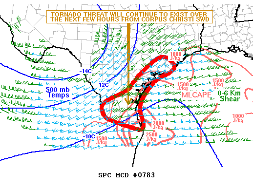
MESOSCALE DISCUSSION 0781
NWS STORM PREDICTION CENTER NORMAN OK
0718 PM CDT THU MAY 10 2012

AREAS AFFECTED...PORTIONS OF SOUTH/CENTRAL TX EWD TO THE
LOWER/MIDDLE TX COAST

CONCERNING...SEVERE POTENTIAL...TORNADO WATCH LIKELY

VALID 110018Z - 110115Z

PROBABILITY OF WATCH ISSUANCE...95 PERCENT

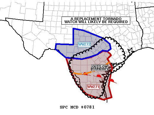
SUMMARY...A NEW TORNADO WATCH WILL LIKELY BE REQUIRED BY 01Z...WHICH
WOULD REPLACE PORTIONS OF BOTH TORNADO WATCH 271 AND SEVERE
THUNDERSTORM WATCH 272...AND CONTINUE THROUGH THE OVERNIGHT HOURS.

DISCUSSION...PRESENT INDICATIONS ARE THAT SUPERCELLS WILL CONTINUE
TRACKING EWD INVOF A QUASI-STATIONARY OUTFLOW BOUNDARY EXTENDING
FROM WEBB COUNTY EWD TOWARD LIVE OAK COUNTY AND NEWD INTO VICTORIA
COUNTY...WITH THIS ACTIVITY EVENTUALLY REACHING THE LOWER/MIDDLE TX
COAST BY LATE EVENING.

ADDITIONAL STORMS CONTINUE DEVELOPING IN ASSOCIATION WITH ISENTROPIC
ASCENT NORTH OF THE OUTFLOW BOUNDARY. AS SURFACE-BASED BUOYANCY
ADVANCES NWD NEAR AND SOUTH OF A WARM FRONT EXTENDING FROM WEBB TO
NUECES COUNTIES...THESE STORMS WILL HAVE THE POTENTIAL TO BECOME
SFC-BASED DURING THE NEXT FEW HOURS...WHILE MORE ISOLATED SFC-BASED
CONVECTION MOVES ACROSS THE WARM SECTOR -- E.G. SUPERCELL
APPROACHING ZAPATA COUNTY FROM THE WEST.

LARGE HAIL -- POTENTIALLY SIGNIFICANT -- AND DMGG WIND GUSTS WILL BE
THE GREATEST CONCERN WITH THE STORMS...AS 00Z CORPUS
CHRISTI/BROWNSVILLE RAOBS SUGGEST THE PRESENCE OF STRONG
INSTABILITY. ALSO...AS BELOW-1-KM-AGL FLOW MAINTAINS AN ELY
COMPONENT BENEATH MODERATE WLY MID-LEVEL FLOW ALOFT...EFFECTIVE SRH
VALUES ON THE ORDER OF 150-300 M2/S2 -- HIGHEST INVOF THE
AFOREMENTIONED BOUNDARIES -- WILL SUPPORT A TORNADO
THREAT...PARTICULARLY WITH ANY DISCRETE/SEMI-DISCRETE SUPERCELLS.
HOWEVER...AS LARGE-SCALE ASCENT INCREASES AMIDST THE RICH LOW-LEVEL
MOISTURE...INCREASING CONVECTIVE COVERAGE WILL LIKELY SUPPORT AN
EVOLUTION TOWARD ONE OR MORE FORWARD-PROPAGATING CONVECTIVE
SYSTEMS...WITH AN INCREASING CONCERN FOR DMGG WIND GUSTS THROUGH THE
LATE EVENING/OVERNIGHT HOURS AS STORMS MOVE TOWARD THE LOWER/MIDDLE
TX COAST.

..COHEN/CARBIN.. 05/11/2012


ATTN...WFO...HGX...FWD...CRP...EWX...BRO...

LAT...LON 28250027 28830030 29369984 29809855 30749693 29769567
28879553 28329608 27899698 27029738 26239772 26259871
27179958 28250027
0 likes   
The following post is NOT an official forecast and should not be used as such. It is just the opinion of the poster and may or may not be backed by sound meteorological data. It is NOT endorsed by any professional institution including storm2k.org For Official Information please refer to the NHC and NWS products.

User avatar
Rgv20
S2K Supporter
S2K Supporter
Posts: 2466
Age: 38
Joined: Wed Jan 05, 2011 5:42 pm
Location: Edinburg/McAllen Tx

#382 Postby Rgv20 » Thu May 10, 2012 8:06 pm

Image

URGENT - IMMEDIATE BROADCAST REQUESTED
TORNADO WATCH NUMBER 273
NWS STORM PREDICTION CENTER NORMAN OK
750 PM CDT THU MAY 10 2012

THE NWS STORM PREDICTION CENTER HAS ISSUED A
TORNADO WATCH FOR PORTIONS OF

SOUTH-CENTRAL AND DEEP SOUTH TEXAS
COASTAL WATERS

EFFECTIVE THIS THURSDAY NIGHT AND FRIDAY MORNING FROM 750 PM
UNTIL 300 AM CDT.

SEVERAL TORNADOES
WIDELY SCATTERED DAMAGING WINDS
ISOLATED WIND GUSTS TO 70 MPH POSSIBLE
SCATTERED LARGE HAIL
ISOLATED HAIL TO 2.0 INCHES IN DIAMETER POSSIBLE

THE TORNADO WATCH AREA IS APPROXIMATELY ALONG AND 70 STATUTE
MILES EAST AND WEST OF A LINE FROM 45 MILES NORTHWEST OF COLLEGE
STATION TEXAS TO 75 MILES SOUTH SOUTHWEST OF ALICE TEXAS. FOR A
COMPLETE DEPICTION OF THE WATCH SEE THE ASSOCIATED WATCH OUTLINE
UPDATE (WOUS64 KWNS WOU3).

REMEMBER...A TORNADO WATCH MEANS CONDITIONS ARE FAVORABLE FOR
TORNADOES AND SEVERE THUNDERSTORMS IN AND CLOSE TO THE WATCH
AREA. PERSONS IN THESE AREAS SHOULD BE ON THE LOOKOUT FOR
THREATENING WEATHER CONDITIONS AND LISTEN FOR LATER STATEMENTS
AND POSSIBLE WARNINGS.

OTHER WATCH INFORMATION...THIS TORNADO WATCH REPLACES TORNADO
WATCH NUMBER 271...SEVERE THUNDERSTORM WATCH NUMBER 272. WATCH
NUMBER 271 272 WILL NOT BE IN EFFECT AFTER 750 PM CDT.

DISCUSSION...SEVERE STORM AND TORNADO THREAT WILL PERSIST ACROSS
PORTIONS OF SRN AND SCNTRL TX TONIGHT AS UPPER LOW DEVELOPS EAST
FROM WEST TX AND BELT OF STRONGER MID LEVEL WLY FLOW SPREADS ACROSS
WARM AND UNSTABLE AIRMASS. GREATEST SHORT-TERM THREAT WILL BE ALONG
A OUTFLOW REINFORCED WARM FRONT FROM WEBB COUNTY EAST TO CRP/VCT
AREA. ANOTHER LINEAR BAND OF STORMS WITH LEWP/BOW STRUCTURES WILL
MOVE EAST INTO MARGINALLY UNSTABLE BUT STRONGLY SHEARED REGIME ALONG
I35 CORRIDOR FROM SAN ANTONIO NORTH TO BELL/MILAM COUNTIES. IN
ADDITION TO TORNADO POTENTIAL WITH SOME OF THESE STORMS...LARGE HAIL
AND EXTREME RAINFALL WILL ALSO BE LIKELY. EVOLVING COLD POOLS AND
PERSISTENT ASCENT WITH THE EWD PROGRESSION OF THE UPPER SYSTEM
SHOULD SUPPORT/MAINTAIN MCS AND DAMAGING WIND POTENTIAL WELL INTO
THE NIGHT PERHAPS AS FAR EAST AS WHARTON COUNTY AND AS FAR SOUTH AS
KENEDY COUNTY.

AVIATION...TORNADOES AND A FEW SEVERE THUNDERSTORMS WITH HAIL
SURFACE AND ALOFT TO 2 INCHES. EXTREME TURBULENCE AND SURFACE
WIND GUSTS TO 60 KNOTS. A FEW CUMULONIMBI WITH MAXIMUM TOPS TO
600. MEAN STORM MOTION VECTOR 24030.


...CARBIN
0 likes   
The following post is NOT an official forecast and should not be used as such. It is just the opinion of the poster and may or may not be backed by sound meteorological data. It is NOT endorsed by any professional institution including storm2k.org For Official Information please refer to the NHC and NWS products.

User avatar
Rgv20
S2K Supporter
S2K Supporter
Posts: 2466
Age: 38
Joined: Wed Jan 05, 2011 5:42 pm
Location: Edinburg/McAllen Tx

#383 Postby Rgv20 » Thu May 10, 2012 8:23 pm

Some nasty Storms close to the Alice area.....Radar indicates that Storm L1 and N3 are capable of producing a Tornado.

Image
0 likes   
The following post is NOT an official forecast and should not be used as such. It is just the opinion of the poster and may or may not be backed by sound meteorological data. It is NOT endorsed by any professional institution including storm2k.org For Official Information please refer to the NHC and NWS products.

User avatar
Portastorm
Storm2k Moderator
Storm2k Moderator
Posts: 9914
Age: 62
Joined: Fri Jul 11, 2003 9:16 am
Location: Round Rock, TX
Contact:

#384 Postby Portastorm » Thu May 10, 2012 9:02 pm

Nothing too dramatic here in Austin despite the Severe T-Storm Warning ... here at the Portastorm Weather Center we have heavy rain and a little cloud-to-ground lightning. The northern 'burbs and Round Rock and Georgetown are getting it worse.

I bet our friend Shoshana is getting quite a storm at the moment (9 pm Thur).
0 likes   
Any forecasts under my name are to be taken with a grain of salt. Get your best forecasts from the National Weather Service and National Hurricane Center.

Shoshana
Category 5
Category 5
Posts: 1414
Joined: Thu Sep 09, 2004 7:50 pm
Location: NE Austin

Re: Texas Spring 2012

#385 Postby Shoshana » Thu May 10, 2012 10:23 pm

Yup! The heaviest rain went right over our house! Stil a lot of lightning and thunder and it's still raining. No hail as far as I could tell.

I found the rain gauge (it flew off the patio) just before it started raining. I'm not going to be surprised to see 2.5-3" of rain in it.

On another note, the Thundershirt I got the dog seems to be helping.
0 likes   

weatherdude1108
Category 5
Category 5
Posts: 4228
Joined: Tue Dec 13, 2011 1:04 pm
Location: Northwest Austin/Cedar Park, TX

#386 Postby weatherdude1108 » Thu May 10, 2012 10:42 pm

It was INSANE TORRENTIAL at my house.

We got 2.2 inches in 20 MINUTES!  Weathercasters just verified lots of reports like that around area.  

My garage had water in it. I found Earthworms making their ways into the garage in order to escape their own flooded homes down under.
0 likes   

User avatar
Rgv20
S2K Supporter
S2K Supporter
Posts: 2466
Age: 38
Joined: Wed Jan 05, 2011 5:42 pm
Location: Edinburg/McAllen Tx

#387 Postby Rgv20 » Thu May 10, 2012 11:12 pm

Tornado Warning

SEVERE WEATHER STATEMENT
NATIONAL WEATHER SERVICE BROWNSVILLE TX
1106 PM CDT THU MAY 10 2012

TXC505-110430-
/O.CON.KBRO.TO.W.0016.000000T0000Z-120511T0430Z/
ZAPATA-
1106 PM CDT THU MAY 10 2012

...A TORNADO WARNING REMAINS IN EFFECT UNTIL 1130 PM CDT FOR CENTRAL
ZAPATA COUNTY...

AT 1105 PM CDT NATIONAL WEATHER SERVICE METEOROLOGISTS CONTINUED TO
TRACK A TORNADO ON RADAR 5 MILES WEST OF ZAPATA...MOVING EAST AT 25
MPH. RESIDENTS OF THE ZAPATA AREA SHOULD TAKE COVER IMMEDIATELY.
INCLUDING SIESTA SHORES AND THE HIGHWAY 83 AREA NEAR ZAPATA. IN
ADDITION TO THE THREAT OF A TORNADO...STRAIGHT LINE WINDS TO 80 MPH
AND GOLF BALL SIZED HAIL IS POSSIBLE.

THE TORNADO WILL BE NEAR...
LINDA VISTA.
BLACK BASS.
BUSTAMANTE.

PRECAUTIONARY/PREPAREDNESS ACTIONS...

TORNADOES ARE ESPECIALLY DANGEROUS AT NIGHT. TAKE COVER NOW! MOVE TO
A SMALL INTERIOR ROOM ON THE LOWEST FLOOR. ABANDON MOBILE HOMES. IF
IN A VEHICLE AND THERE IS NO STURDY BUILDING NEARBY...PARK. CLOSE
WINDOWS...LEAVE SEATBELTS ON...GET LOWER THAN THE DASHBOARD...AND
COVER YOUR HEAD...PREFERABLY WITH BLANKETS OR PILLOWS. IF THERE IS NO
DEBRIS...LEAVE THE VEHICLE AND GO INTO A DITCH OR LOW SPOT...BUT
WATCH FOR RISING WATERS.

&&
0 likes   
The following post is NOT an official forecast and should not be used as such. It is just the opinion of the poster and may or may not be backed by sound meteorological data. It is NOT endorsed by any professional institution including storm2k.org For Official Information please refer to the NHC and NWS products.

User avatar
Rgv20
S2K Supporter
S2K Supporter
Posts: 2466
Age: 38
Joined: Wed Jan 05, 2011 5:42 pm
Location: Edinburg/McAllen Tx

#388 Postby Rgv20 » Thu May 10, 2012 11:22 pm

The Tornado Watch has been expanded South to include the Rio Grande Valley area.


Tornado Watch

WATCH COUNTY NOTIFICATION FOR WATCH 273
NATIONAL WEATHER SERVICE BROWNSVILLE TX
1050 PM CDT THU MAY 10 2012

TXC061-215-427-489-110800-
/O.EXA.KBRO.TO.A.0273.000000T0000Z-120511T0800Z/

THE NATIONAL WEATHER SERVICE HAS EXTENDED TORNADO WATCH 273 TO
INCLUDE THE FOLLOWING AREAS UNTIL 3 AM CDT FRIDAY

IN TEXAS THIS WATCH INCLUDES 4 COUNTIES

IN DEEP SOUTH TEXAS

CAMERON HIDALGO STARR
WILLACY

THIS INCLUDES THE CITIES OF...BROWNSVILLE...EDINBURG...
HARLINGEN...MCALLEN...MISSION...PHARR...RAYMONDVILLE...
RIO GRANDE CITY...ROMA AND WESLACO.
0 likes   
The following post is NOT an official forecast and should not be used as such. It is just the opinion of the poster and may or may not be backed by sound meteorological data. It is NOT endorsed by any professional institution including storm2k.org For Official Information please refer to the NHC and NWS products.

User avatar
Rgv20
S2K Supporter
S2K Supporter
Posts: 2466
Age: 38
Joined: Wed Jan 05, 2011 5:42 pm
Location: Edinburg/McAllen Tx

#389 Postby Rgv20 » Thu May 10, 2012 11:42 pm

Good thing its mostly ranch land in the warned area..

TORNADO WARNING

TXC247-427-110515-
/O.NEW.KBRO.TO.W.0018.120511T0433Z-120511T0515Z/

BULLETIN - EAS ACTIVATION REQUESTED
TORNADO WARNING
NATIONAL WEATHER SERVICE BROWNSVILLE TX
1133 PM CDT THU MAY 10 2012

THE NATIONAL WEATHER SERVICE IN BROWNSVILLE HAS ISSUED A

* TORNADO WARNING FOR...
SOUTHWESTERN JIM HOGG COUNTY IN DEEP SOUTH TEXAS.
NORTHERN STARR COUNTY IN DEEP SOUTH TEXAS.

* UNTIL 1215 AM CDT

* AT 1132 PM CDT...NATIONAL WEATHER SERVICE METEOROLOGISTS WERE
TRACKING A TORNADO ON RADAR 18 MILES WEST OF VIBORAS...MOVING EAST
AT 50 MPH. THIS TORNADO WILL BE WRAPPED IN RAIN AND IMPOSSIBLE TO
SEE. DO NOT WAIT UNTIL YOU SEE THE TORNADO TO TAKE COVER.

* THE TORNADO WILL BE NEAR...
VIBORAS....AND GUERRA.

PRECAUTIONARY/PREPAREDNESS ACTIONS...

THIS IS A DANGEROUS STORM! MOVE INTO THE INTERIOR ROOM ON THE LOWEST
FLOOR OF A STURDY BUILDING...AWAY FROM WINDOWS. COVER YOUR HEAD AND
BODY WITH PILLOWS OR BLANKETS.

TORNADOES ARE ESPECIALLY DANGEROUS AT NIGHT. TAKE COVER NOW! MOVE TO
A SMALL INTERIOR ROOM ON THE LOWEST FLOOR. ABANDON MOBILE HOMES. IF
IN A VEHICLE AND THERE IS NO STURDY BUILDING NEARBY...PARK. CLOSE
WINDOWS...LEAVE SEATBELTS ON...GET LOWER THAN THE DASHBOARD...AND
COVER YOUR HEAD...PREFERABLY WITH BLANKETS OR PILLOWS. IF THERE IS NO
DEBRIS...LEAVE THE VEHICLE AND GO INTO A DITCH OR LOW SPOT...BUT
WATCH FOR RISING WATERS.
0 likes   
The following post is NOT an official forecast and should not be used as such. It is just the opinion of the poster and may or may not be backed by sound meteorological data. It is NOT endorsed by any professional institution including storm2k.org For Official Information please refer to the NHC and NWS products.

User avatar
Rgv20
S2K Supporter
S2K Supporter
Posts: 2466
Age: 38
Joined: Wed Jan 05, 2011 5:42 pm
Location: Edinburg/McAllen Tx

#390 Postby Rgv20 » Thu May 10, 2012 11:59 pm

Image

MESOSCALE DISCUSSION 0783
NWS STORM PREDICTION CENTER NORMAN OK
1136 PM CDT THU MAY 10 2012

AREAS AFFECTED...SOUTH TX...LOWER TO MIDDLE TX COAST

CONCERNING...TORNADO WATCH 273...

VALID 110436Z - 110600Z

THE SEVERE WEATHER THREAT FOR TORNADO WATCH 273 CONTINUES.

SUMMARY...THE TORNADO THREAT MAY CONTINUE FOR ANOTHER HOUR OR TWO
ACROSS SOUTH TX. IN ADDITION...LARGE HAIL AND WIND DAMAGE MAY
ACCOMPANY THE MORE INTENSE THUNDERSTORMS. THE SEVERE THREAT MAY
DECREASE ACROSS PARTS OF THE MIDDLE TX COAST AS A CONVECTIVE LINE
MOVES NEWD TOWARDS WHARTON AND MATAGORDA COUNTIES OVER THE NEXT 1 TO
2 HOURS.

DISCUSSION...THE LATEST SFC ANALYSIS SHOWS A WELL-DEFINED OUTFLOW
BOUNDARY FROM NEAR CORPUS CHRISTI EXTENDING SSWWD TO WEST OF RIO
GRANDE CITY IN FAR SOUTH TX. STRONG TO SEVERE THUNDERSTORMS ARE
ONGOING ALONG THE BOUNDARY WITH SFC DEWPOINTS AHEAD OF THE STORMS IN
THE MID 70S AND MESOANALYSIS SHOWING MODERATE INSTABILITY IN PLACE.
THIS ALONG WITH STRONG LARGE-SCALE ASCENT ASSOCIATED WITH AN
UPPER-LEVEL LOW OVER WEST TX WILL ALLOW THE THUNDERSTORM ACTIVITY TO
PERSIST INTO THE OVERNIGHT PERIOD. THE MOIST BOUNDARY LAYER...LOW
LCL HEIGHTS AND STRENGTHENING LOW-LEVEL SHEAR MAY RESULT IN A
CONTINUED TORNADO THREAT FOR ANOTHER HOUR OR TWO. THIS THREAT ALONG
WITH A POTENTIAL FOR LARGE HAIL AND WIND DAMAGE IS EXPECTED TO
DEVELOP SEWD INTO EXTREME SOUTH TX AFTER MIDNIGHT WHERE MLCAPE
VALUES ARE MAXIMIZED IN THE 2000 TO 3000 J/KG.

..BROYLES.. 05/11/2012


ATTN...WFO...HGX...CRP...BRO...
0 likes   
The following post is NOT an official forecast and should not be used as such. It is just the opinion of the poster and may or may not be backed by sound meteorological data. It is NOT endorsed by any professional institution including storm2k.org For Official Information please refer to the NHC and NWS products.

Shoshana
Category 5
Category 5
Posts: 1414
Joined: Thu Sep 09, 2004 7:50 pm
Location: NE Austin

Re:

#391 Postby Shoshana » Thu May 10, 2012 11:59 pm

Yup, glad those tornadoes are not closer to towns!

weatherdude1108 wrote:It was INSANE TORRENTIAL at my house.

We got 2.2 inches in 20 MINUTES!  Weathercasters just verified lots of reports like that around area.  

My garage had water in it. I found Earthworms making their ways into the garage in order to escape their own flooded homes down under.


Yuk. I went out about an hour ago and it was still sprinkling and the rain gauge was at 3.1" All that is just from that one band of rain.

No flooding here - we live on the side of a hill and the rain flows around our house.
0 likes   

User avatar
Rgv20
S2K Supporter
S2K Supporter
Posts: 2466
Age: 38
Joined: Wed Jan 05, 2011 5:42 pm
Location: Edinburg/McAllen Tx

#392 Postby Rgv20 » Fri May 11, 2012 12:20 am

Tornado Warning

SEVERE WEATHER STATEMENT
NATIONAL WEATHER SERVICE BROWNSVILLE TX
1217 AM CDT FRI MAY 11 2012

TXC047-247-110600-
/O.CON.KBRO.TO.W.0021.000000T0000Z-120511T0600Z/
JIM HOGG-BROOKS-
1217 AM CDT FRI MAY 11 2012

...A TORNADO WARNING REMAINS IN EFFECT UNTIL 100 AM CDT FOR CENTRAL
BROOKS AND CENTRAL JIM HOGG COUNTIES...

AT 1216 AM CDT NATIONAL WEATHER SERVICE METEOROLOGISTS CONTINUED TO
TRACK A TORNADO ON RADAR 5 MILES NORTHWEST OF AGUA NUEVA...MOVING EAST
AT 40 MPH. SPOTTERS REPORTED A TORNADO TOUCHDOWN SOUTHEAST OF
RANDADO WHEN THIS STORM MOVED THROUGH.


THE TORNADO WILL BE NEAR...
AGUA NUEVA.
ENCINO.

PRECAUTIONARY/PREPAREDNESS ACTIONS...

PLEASE REPORT TORNADOES OR FUNNEL CLOUDS...WINDS OF 58 MPH OR
HIGHER...HAIL THE SIZE OF PENNIES OR LARGER...AND ANY WIND DAMAGE TO
YOUR NATIONAL WEATHER SERVICE IN BROWNSVILLE BY CALLING 956-504-1432.

&&


LAT...LON 2712 9806 2681 9807 2682 9873 2706 9874
TIME...MOT...LOC 0516Z 267DEG 33KT 2696 9859

$$

JGG
0 likes   
The following post is NOT an official forecast and should not be used as such. It is just the opinion of the poster and may or may not be backed by sound meteorological data. It is NOT endorsed by any professional institution including storm2k.org For Official Information please refer to the NHC and NWS products.

ndale
Category 1
Category 1
Posts: 429
Joined: Tue Dec 29, 2009 11:12 am
Location: Pflugerville/Austin Tx

Re:

#393 Postby ndale » Fri May 11, 2012 7:09 am

weatherdude1108 wrote:It was INSANE TORRENTIAL at my house.

We got 2.2 inches in 20 MINUTES!  Weathercasters just verified lots of reports like that around area.  

My garage had water in it. I found Earthworms making their ways into the garage in order to escape their own flooded homes down under.


I don't have a rain gauge so I don't have a total but I know we had torrential rain for awhile with some small hail and moderate winds but no damage was done.
0 likes   
Any opinions stated are those of an amateur, please take with several grains of salt and for official forecast refer to the National Weather Service.

User avatar
Portastorm
Storm2k Moderator
Storm2k Moderator
Posts: 9914
Age: 62
Joined: Fri Jul 11, 2003 9:16 am
Location: Round Rock, TX
Contact:

Re: Re:

#394 Postby Portastorm » Fri May 11, 2012 8:56 am

ndale wrote:
weatherdude1108 wrote:It was INSANE TORRENTIAL at my house.

We got 2.2 inches in 20 MINUTES!  Weathercasters just verified lots of reports like that around area.  

My garage had water in it. I found Earthworms making their ways into the garage in order to escape their own flooded homes down under.


I don't have a rain gauge so I don't have a total but I know we had torrential rain for awhile with some small hail and moderate winds but no damage was done.


We saw 2.3 inches of glorious rainfall at the Portastorm Weather Center. No severe though, which is fine by me. I can't get over how different our weather this spring has been as compared to last year ... and I'm so thankful for the difference! :D
0 likes   
Any forecasts under my name are to be taken with a grain of salt. Get your best forecasts from the National Weather Service and National Hurricane Center.

aggiecutter
Category 5
Category 5
Posts: 1751
Joined: Thu Oct 14, 2004 9:22 pm
Location: Texarkana

#395 Postby aggiecutter » Fri May 11, 2012 2:32 pm

:double: :flag: :cold: :ggreen: :bathroom: :sun: :darrow: :rarrow: :grrr: :D 8-) :grr: :eek: :lol: :x :roll: :oops: :idea: :?: :( :) :cheesy: :cold: :flag: :double: :spam: :froze: :sun:
0 likes   

User avatar
Portastorm
Storm2k Moderator
Storm2k Moderator
Posts: 9914
Age: 62
Joined: Fri Jul 11, 2003 9:16 am
Location: Round Rock, TX
Contact:

Re: Texas Spring 2012

#396 Postby Portastorm » Fri May 11, 2012 3:16 pm

Uh oh ... could be some trouble later this afternoon in my neck of the woods. SPC has a mesoscale discussion out for much of central Texas.

http://www.spc.noaa.gov/products/md/md0787.html
0 likes   
Any forecasts under my name are to be taken with a grain of salt. Get your best forecasts from the National Weather Service and National Hurricane Center.

Shoshana
Category 5
Category 5
Posts: 1414
Joined: Thu Sep 09, 2004 7:50 pm
Location: NE Austin

Re: Texas Spring 2012

#397 Postby Shoshana » Fri May 11, 2012 6:45 pm

Portastorm wrote:Uh oh ... could be some trouble later this afternoon in my neck of the woods. SPC has a mesoscale discussion out for much of central Texas.

http://www.spc.noaa.gov/products/md/md0787.html


So far it's cloudy and humid. Wonder if they've got any kind of time frame yet ...
0 likes   

User avatar
Ntxw
Storm2k Moderator
Storm2k Moderator
Posts: 22731
Joined: Wed Oct 21, 2009 6:34 pm
Location: DFW, Texas

#398 Postby Ntxw » Fri May 11, 2012 7:57 pm

With the latest storm slowly exiting time to look forward to our next chances. Early week will probably bring a weak system mostly giving rain to NW and W Texas. Then things look to warm up a bit (though nothing extreme).

Weather patterns during transition periods can give hints as to what one can expect in the following season. Thus far heat ridging has been confined to the southwest. The EPAC is starting to get active with many waves of systems and should one organize the persistent weakness in the atmosphere over Texas should allow moisture from these waves to be entrenched down the line. That's where I would look for our weather in the coming weeks towards the summer solstice!
0 likes   
The above post and any post by Ntxw is NOT an official forecast and should not be used as such. It is just the opinion of the poster and may or may not be backed by sound meteorological data. It is NOT endorsed by any professional institution including Storm2k. For official information, please refer to NWS products.

  Help support Storm2K!
Help Support Storm2K

weatherdude1108
Category 5
Category 5
Posts: 4228
Joined: Tue Dec 13, 2011 1:04 pm
Location: Northwest Austin/Cedar Park, TX

Re: Re:

#399 Postby weatherdude1108 » Sun May 13, 2012 10:35 pm

Portastorm wrote:
ndale wrote:
weatherdude1108 wrote:It was INSANE TORRENTIAL at my house.

We got 2.2 inches in 20 MINUTES!  Weathercasters just verified lots of reports like that around area.  

My garage had water in it. I found Earthworms making their ways into the garage in order to escape their own flooded homes down under.


I don't have a rain gauge so I don't have a total but I know we had torrential rain for awhile with some small hail and moderate winds but no damage was done.


We saw 2.3 inches of glorious rainfall at the Portastorm Weather Center. No severe though, which is fine by me. I can't get over how different our weather this spring has been as compared to last year ... and I'm so thankful for the difference! :D


Oh yeah! I'm lovin' it! :P Just have this "NDS" brand buried drain pipe I inherited with house, going from corner of garage along side of house, emptying through a pop-up mechanism on other end of pipe into backyard. The intelligent builder/Engineer who built the house decided to slope our driveway towards house instead of digging the driveway lower than garage to divert water further away. When it rains hard enough like Thursday night, it overwhelms the 4-inch diameter hole and temporarily floods garage floor. The debris line (mulch/soil/leaves) on the garage was about 6 inches up the garage door. Had a landscape contractor dig a low spot to drain water to side, to no avail. Ah well, small price to pay for free water in the big picture! :wink: :rain:
0 likes   

User avatar
cctxhurricanewatcher
Category 5
Category 5
Posts: 1206
Joined: Sun Sep 12, 2004 8:53 pm
Location: Corpus Christi, Texas

Re: Texas Spring 2012

#400 Postby cctxhurricanewatcher » Mon May 14, 2012 9:21 am

Pics from Storm Damage in NW Corpus Christi (Calallen/Annaville) from the May 10 Super Storm. Too many to post indiviudal pics

Calallen Baseball Field

http://www.kristv.com/news/mother-natur ... all-field/

Other Damage in NW Corpus

http://www.caller.com/photos/galleries/ ... rm-damage/

NWS Corpus Christi Storm Survey with Pics

http://www.srh.noaa.gov/news/display_cm ... 5&source=0

I am so ready for the hot and dry dog days of summer!
0 likes   


Return to “USA & Caribbean Weather”

Who is online

Users browsing this forum: South Texas Storms and 46 guests