ENSO Updates (2007 thru 2023)

This is the general tropical discussion area. Anyone can take their shot at predicting a storms path.

Moderator: S2k Moderators

Forum rules

The posts in this forum are NOT official forecasts and should not be used as such. They are just the opinion of the poster and may or may not be backed by sound meteorological data. They are NOT endorsed by any professional institution or STORM2K. For official information, please refer to products from the National Hurricane Center and National Weather Service.

Help Support Storm2K
Message
Author
User avatar
cycloneye
Admin
Admin
Posts: 145299
Age: 68
Joined: Thu Oct 10, 2002 10:54 am
Location: San Juan, Puerto Rico

Re: ENSO Updates

#2061 Postby cycloneye » Fri May 11, 2012 9:30 pm

Hurricaneman wrote:is it possible that the El Nino will be slower to occour because of the +SOI


If the SOI stays between +8 and -8,then it will remain Neutral. Below is from the Australians ENSO page.

Sustained positive values of the SOI above +8 may indicate a La Niña event, while sustained negative values below −8 may indicate an El Niño event. Values of between about +8 and −8 generally indicate neutral conditions. The Southern Oscillation Index, or SOI, gives an indication of the development and intensity of El Niño or La Niña events in the Pacific Ocean. The SOI is calculated using the pressure differences between Tahiti and Darwin. The following figure demonstrates the typical fluctuations in SOI over a period of 11 years. Positive SOI values are shown in blue, with negative in orange. Sustained positive values are indicative of La Niña conditions, and sustained negative values indicative of El Niño conditions.

http://www.bom.gov.au/watl/about-weathe ... kmark=enso

http://www.bom.gov.au/climate/enso/
0 likes   
Visit the Caribbean-Central America Weather Thread where you can find at first post web cams,radars
and observations from Caribbean basin members Click Here

User avatar
Kingarabian
S2K Supporter
S2K Supporter
Posts: 15980
Joined: Sat Aug 08, 2009 3:06 am
Location: Honolulu, Hawaii

#2062 Postby Kingarabian » Sat May 12, 2012 3:25 am

Up to 2300 birds found dead along Chile.

Possible correlation with the effects of El-Nino.

http://www.cnn.com/2012/05/12/world/ame ... ?hpt=hp_t1
0 likes   
RIP Kobe Bryant

User avatar
NDG
S2K Supporter
S2K Supporter
Posts: 15446
Joined: Sun Jul 09, 2006 10:14 pm
Location: Orlando, FL

Re:

#2063 Postby NDG » Sat May 12, 2012 7:07 am

Kingarabian wrote:Up to 2300 birds found dead along Chile.

Possible correlation with the effects of El-Nino.

http://www.cnn.com/2012/05/12/world/ame ... ?hpt=hp_t1


The weird thing to this story is that there is no stories from fishermen complaining about having a bad fishing season. Is weird that so many dolphins and pelicans have died as such high numbers fairly much all at once.
I think they are blaming the warm SSTs versus investigating if it is a virus instead.
0 likes   

User avatar
NDG
S2K Supporter
S2K Supporter
Posts: 15446
Joined: Sun Jul 09, 2006 10:14 pm
Location: Orlando, FL

Re: ENSO Updates

#2064 Postby NDG » Sat May 12, 2012 8:41 am

cycloneye wrote:I have a question for wxman57 regarding the NCEP models CFS and CFSv2. They look very different with those forecasts. Why is that?

CFS:

Image

CFSv2:

Image

Both uploaded with imageshack.us


Hmm, according to the CFSv2 back then, it was forecasting Nino 3.4 to be nearing +.4 deg C by May 15th if you average it out, doubt that it will go from -.1 deg C (May 7th) to +.4 deg C in a week.
0 likes   

User avatar
Ntxw
Storm2k Moderator
Storm2k Moderator
Posts: 22784
Joined: Wed Oct 21, 2009 6:34 pm
Location: DFW, Texas

Re: ENSO Updates

#2065 Postby Ntxw » Sat May 12, 2012 2:03 pm

Peruvian government states Pelican deaths to warmer waters. Western ENSO is not El Nino warm but eastern regions are and seems like it continues to effect marine life.

http://www.cnn.com/2012/05/11/world/americas/peru-pelicans/

(CNN) -- Warm waters off Peru are to blame in the deaths of more than 5,000 marine birds on the coast, government authorities say.

The Peruvian National Center for the Study of El Nino reported earlier this week that since February the Peruvian coast has had an abundance of warm water as a result of marine currents throughout the world's oceans. The warm water has altered the marine ecosystem, it said.

The warm water has led fish such as anchovy and other species that live in surface waters to migrate to deeper water toward the south. As a result, pelicans and other birds that feed from the surface of the water died of starvation.

"If these oceanographic conditions persist, it is likely that its impact will spread to other areas of the (Peruvian) coast even during the fall, which could make the numbers increase and affect other marine species" said the report.


Looks like the subsurface warm pool may be a player here. Light easterly trades are still present in the western regions as reflective the SOI continues to go positive. Will be interesting to see how the atmosphere (SOI) effects water temperatures in the ENSO regions.
0 likes   
The above post and any post by Ntxw is NOT an official forecast and should not be used as such. It is just the opinion of the poster and may or may not be backed by sound meteorological data. It is NOT endorsed by any professional institution including Storm2k. For official information, please refer to NWS products.

  Help support Storm2K!
Help Support Storm2K

User avatar
cycloneye
Admin
Admin
Posts: 145299
Age: 68
Joined: Thu Oct 10, 2002 10:54 am
Location: San Juan, Puerto Rico

Re: ENSO Updates

#2066 Postby cycloneye » Sat May 12, 2012 8:29 pm

And the SOI uptick continues,now up to +4.9.

Image
0 likes   
Visit the Caribbean-Central America Weather Thread where you can find at first post web cams,radars
and observations from Caribbean basin members Click Here

User avatar
Evil Jeremy
S2K Supporter
S2K Supporter
Posts: 5463
Age: 32
Joined: Mon Apr 10, 2006 2:10 pm
Location: Los Angeles, CA

Re: ENSO Updates

#2067 Postby Evil Jeremy » Sat May 12, 2012 8:43 pm

I don't know much about El Nino/La Nina calculations, but am I right in thinking that we are much closer to La Nina now than to El Nino?
0 likes   
Frances 04 / Jeanne 04 / Katrina 05 / Wilma 05 / Fay 08 / Debby 12 / Andrea 13 / Colin 16 / Hermine 16 / Matthew 16 / Irma 17

User avatar
cycloneye
Admin
Admin
Posts: 145299
Age: 68
Joined: Thu Oct 10, 2002 10:54 am
Location: San Juan, Puerto Rico

Re: ENSO Updates

#2068 Postby cycloneye » Sat May 12, 2012 8:52 pm

Evil Jeremy wrote:I don't know much about El Nino/La Nina calculations, but am I right in thinking that we are much closer to La Nina now than to El Nino?


Well,if this uptick continues and the index surpasses the +8 line,then yes La Nina.But I dont think this uptick will last too long,We will see.

Here is an explanation about the SOI.

Sustained positive values of the SOI above +8 may indicate a La Niña event, while sustained negative values below −8 may indicate an El Niño event. Values of between about +8 and −8 generally indicate neutral conditions.

The Southern Oscillation Index, or SOI, gives an indication of the development and intensity of El Niño or La Niña events in the Pacific Ocean. The SOI is calculated using the pressure differences between Tahiti and Darwin. The following figure demonstrates the typical fluctuations in SOI over a period of 11 years. Positive SOI values are shown in blue, with negative in orange. Sustained positive values are indicative of La Niña conditions, and sustained negative values indicative of El Niño conditions.

http://www.bom.gov.au/watl/about-weathe ... kmark=enso
0 likes   
Visit the Caribbean-Central America Weather Thread where you can find at first post web cams,radars
and observations from Caribbean basin members Click Here

User avatar
NDG
S2K Supporter
S2K Supporter
Posts: 15446
Joined: Sun Jul 09, 2006 10:14 pm
Location: Orlando, FL

#2069 Postby NDG » Sun May 13, 2012 8:46 am

SOI is up to 5.31 today.

13 May 2012 1013.78 1010.00 17.25 5.31 0.23

http://www.longpaddock.qld.gov.au/seaso ... soivalues/
0 likes   

User avatar
NDG
S2K Supporter
S2K Supporter
Posts: 15446
Joined: Sun Jul 09, 2006 10:14 pm
Location: Orlando, FL

#2070 Postby NDG » Mon May 14, 2012 7:24 am

During the past week Region Nino 4 has seen a slight cool down due to the continuing easterly winds in the central and western Pacific.
While Nino 3.4 has at least remained the same.
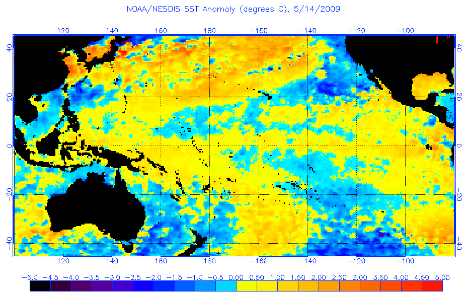
Like I have said during during the past 2 weeks, we are not seeing a repeat of 2009, at least so far this May, IMO.
I am sure the negative PDO might have something to do with keeping warmer waters at bay.

Current
Image

2009
Image
0 likes   

User avatar
cycloneye
Admin
Admin
Posts: 145299
Age: 68
Joined: Thu Oct 10, 2002 10:54 am
Location: San Juan, Puerto Rico

Re: ENSO: CPC 5/14/12 Update=Nino 3.4 up to 0.0C

#2071 Postby cycloneye » Mon May 14, 2012 11:42 am

Climate Prediction Center 5/14/12 Update

Nino 3.4 warmed slightly to 0.0C from last week when it was at -0.1C

http://www.cpc.ncep.noaa.gov/products/a ... ts-web.pdf

Image
0 likes   
Visit the Caribbean-Central America Weather Thread where you can find at first post web cams,radars
and observations from Caribbean basin members Click Here

User avatar
Kingarabian
S2K Supporter
S2K Supporter
Posts: 15980
Joined: Sat Aug 08, 2009 3:06 am
Location: Honolulu, Hawaii

#2072 Postby Kingarabian » Mon May 14, 2012 12:40 pm

Cant wait for the Euro!!!
0 likes   
RIP Kobe Bryant

User avatar
cycloneye
Admin
Admin
Posts: 145299
Age: 68
Joined: Thu Oct 10, 2002 10:54 am
Location: San Juan, Puerto Rico

Re: ENSO: CPC 5/14/12 Update=Nino 3.4 up to 0.0C

#2073 Postby cycloneye » Mon May 14, 2012 9:18 pm

The SOI continues to rise with the updated reading at +5.3.

Image
0 likes   
Visit the Caribbean-Central America Weather Thread where you can find at first post web cams,radars
and observations from Caribbean basin members Click Here

User avatar
hurricanetrack
HurricaneTrack.com
HurricaneTrack.com
Posts: 1781
Joined: Tue Dec 02, 2003 10:46 pm
Location: Wilmington, NC
Contact:

#2074 Postby hurricanetrack » Mon May 14, 2012 9:30 pm

Wow, just seems to me that if El Nino were coming and coming on strong, it would already be doing so. We're two weeks from the start of the ATL season and conditions are neutral, no question about it. Will that be the case come August 15? Wish I knew for sure, but it seems to me that with the SOI 90 day now at .50 and not heading down, that perhaps this Nino, if at all, will be weak at best. However, 3 to 4 months is a long time, relatively speaking, and it can still happen. For now, the current obs suggest neutral for a few more weeks at least.
0 likes   

User avatar
NDG
S2K Supporter
S2K Supporter
Posts: 15446
Joined: Sun Jul 09, 2006 10:14 pm
Location: Orlando, FL

#2075 Postby NDG » Tue May 15, 2012 7:33 am

ECMWF's May update of its Seasonal range forecast, not as warm through July as earlier months.

Image
0 likes   

User avatar
NDG
S2K Supporter
S2K Supporter
Posts: 15446
Joined: Sun Jul 09, 2006 10:14 pm
Location: Orlando, FL

#2076 Postby NDG » Tue May 15, 2012 7:46 am

Another thing that I have noticed from the latest update is that through August there is more of its ensemble members staying in the neutral zone as compared to last month's.
This gives me confidence of my thinking that if we see an El Nino by late August/early September it will be a weak one.
0 likes   

User avatar
Ntxw
Storm2k Moderator
Storm2k Moderator
Posts: 22784
Joined: Wed Oct 21, 2009 6:34 pm
Location: DFW, Texas

Re: ENSO Updates

#2077 Postby Ntxw » Tue May 15, 2012 12:25 pm

My previous thinking of the MJO jumpstarting in May continues to not verify, the MJO has stayed in the ring of death (weak activity) with no model forecasting any uptick in the foreseeable future. Without a significant MJO/Kelvin wave warm waters will be kept at bay. But all it will take is one big wave, however forecasting the MJO has proven to be a challenge.

Image

Uploaded with ImageShack.us
0 likes   
The above post and any post by Ntxw is NOT an official forecast and should not be used as such. It is just the opinion of the poster and may or may not be backed by sound meteorological data. It is NOT endorsed by any professional institution including Storm2k. For official information, please refer to NWS products.


  Help support Storm2K!

Help Support Storm2K


User avatar
cycloneye
Admin
Admin
Posts: 145299
Age: 68
Joined: Thu Oct 10, 2002 10:54 am
Location: San Juan, Puerto Rico

Re: ENSO Updates

#2078 Postby cycloneye » Tue May 15, 2012 3:24 pm

Ntxw wrote:My previous thinking of the MJO jumpstarting in May continues to not verify, the MJO has stayed in the ring of death (weak activity) with no model forecasting any uptick in the foreseeable future. Without a significant MJO/Kelvin wave warm waters will be kept at bay. But all it will take is one big wave, however forecasting the MJO has proven to be a challenge.

[url=http://imageshack.us/photo/my-images/819/58590950.gif/http://img819.imageshack.us/img819/6753/58590950.gif[/url]

Uploaded with ImageShack.us


In other words,a delay of El Nino dominating the Pacific.
0 likes   
Visit the Caribbean-Central America Weather Thread where you can find at first post web cams,radars
and observations from Caribbean basin members Click Here

User avatar
cycloneye
Admin
Admin
Posts: 145299
Age: 68
Joined: Thu Oct 10, 2002 10:54 am
Location: San Juan, Puerto Rico

Re:

#2079 Postby cycloneye » Tue May 15, 2012 8:06 pm

NDG wrote:SOI is up to 5.31 today.

13 May 2012 1013.78 1010.00 17.25 5.31 0.23

http://www.longpaddock.qld.gov.au/seaso ... soivalues/


And the 30 day SOI continues to creep up. tonight at +5.5. At some point it will start to go down.

Image

Uploaded with imageshack.us
0 likes   
Visit the Caribbean-Central America Weather Thread where you can find at first post web cams,radars
and observations from Caribbean basin members Click Here

User avatar
cycloneye
Admin
Admin
Posts: 145299
Age: 68
Joined: Thu Oct 10, 2002 10:54 am
Location: San Juan, Puerto Rico

Re:

#2080 Postby cycloneye » Wed May 16, 2012 6:40 am

NDG wrote:SOI is up to 5.31 today.

13 May 2012 1013.78 1010.00 17.25 5.31 0.23

http://www.longpaddock.qld.gov.au/seaso ... soivalues/


The upward swing is over. Now,let's see how far down it goes or it stairsteps up and down.
0 likes   
Visit the Caribbean-Central America Weather Thread where you can find at first post web cams,radars
and observations from Caribbean basin members Click Here


Return to “Talkin' Tropics”

Who is online

Users browsing this forum: caneman and 49 guests