geez, you Corpus folks are never happy. Last year you were grousing about "no rain" and "drought." Now, you get a little wind and rain and you're ready for hot and dry again?!
Texas Spring 2012
Moderator: S2k Moderators
Forum rules

The posts in this forum are NOT official forecast and should not be used as such. They are just the opinion of the poster and may or may not be backed by sound meteorological data. They are NOT endorsed by any professional institution or STORM2K.
-
Portastorm

- Storm2k Moderator

- Posts: 9955
- Age: 63
- Joined: Fri Jul 11, 2003 9:16 am
- Location: Round Rock, TX
- Contact:
Re: Texas Spring 2012
geez, you Corpus folks are never happy. Last year you were grousing about "no rain" and "drought." Now, you get a little wind and rain and you're ready for hot and dry again?!
0 likes
Any forecasts under my name are to be taken with a grain of salt. Get your best forecasts from the National Weather Service and National Hurricane Center.
-
cctxhurricanewatcher

- Category 5

- Posts: 1206
- Joined: Sun Sep 12, 2004 8:53 pm
- Location: Corpus Christi, Texas
Re: Texas Spring 2012
Portastorm wrote::uarrow:
geez, you Corpus folks are never happy. Last year you were grousing about "no rain" and "drought." Now, you get a little wind and rain and you're ready for hot and dry again?!
One of the TV weather guys said we've had six severe weather events in the last six weeks compared to two for the entire year in 2011. We've been lucky to manage with minimal damage because we don't have large trees in our yard and the hail has missed us by a mile or two in each event. We did lose a good chunk of our fence with this one and a basketball goal. Not so with folks just a couple of blocks from me. Then you have areas here and in the RGV getting hail the size of baseballs and tornados in multiple storm events and you have to be scratching your heads about what the heck is going on?
A "good" side benefit if there is one is the winds the other night go rid of alot of stuff in regards to tree limbs that could come down thanks to a Cat 1 or Cat 2 hurricane this summer if we were to finally get hit by one. A few the old timers around here said they haven't seen damage like this since 1971 and that was when Celia hit Corpus with a direct shot.
Some folks that have put off having their trees professionally trimed might actually get to doing it now to further mitigate damage if a tropical system visits us in the summer. At least I hope so for their sake.
0 likes
-
Portastorm
- Storm2k Moderator
- Posts: 9955
- Age: 63
- Joined: Fri Jul 11, 2003 9:16 am
- Location: Round Rock, TX
- Contact:
Re: Texas Spring 2012
All kidding aside, it seemed like the Corpus NWS office was issuing a tornado warning or severe t-storm warning every 10 minutes on that day (May 10). Y'all certainly had your hands full. Glad the cctx compound didn't endure too much damage.
Interesting news about how Mother Nature has pruned your trees. Hope she's not preparing you for something "bigger" this summer.
I keep thinking how amazing it is . . . how different this spring has been weatherwise in Texas than last year. Really, it seems like it has been several years at least when we have seen this amount of rain/storms.
0 likes
Any forecasts under my name are to be taken with a grain of salt. Get your best forecasts from the National Weather Service and National Hurricane Center.
-
cctxhurricanewatcher
- Category 5
- Posts: 1206
- Joined: Sun Sep 12, 2004 8:53 pm
- Location: Corpus Christi, Texas
Re: Texas Spring 2012
Portastorm wrote:All kidding aside, it seemed like the Corpus NWS office was issuing a tornado warning or severe t-storm warning every 10 minutes on that day (May 10). Y'all certainly had your hands full. Glad the cctx compound didn't endure too much damage.
Interesting news about how Mother Nature has pruned your trees. Hope she's not preparing you for something "bigger" this summer.
I keep thinking how amazing it is . . . how different this spring has been weatherwise in Texas than last year. Really, it seems like it has been several years at least when we have seen this amount of rain/storms.
To put it perspective, here is how many games my baseball boys had PPD due to rain
Number of baseball rainouts in 2011- 0
Number of rainouts in 2012 - 7
It's not like it's raining three or four times a week. It is one good rain one day and it takes another day to dry the fields. Thursday night would have been interesting had we played because everything happened so quickly. There was really no close cloud to ground lighting until right before things hit the fan.
0 likes
-
Rgv20

- S2K Supporter

- Posts: 2466
- Age: 39
- Joined: Wed Jan 05, 2011 5:42 pm
- Location: Edinburg/McAllen Tx
NWS Corpus Christi Special Weather Statement
Special Weather Statement
SPECIAL WEATHER STATEMENT...CORRECTED
NATIONAL WEATHER SERVICE CORPUS CHRISTI TX
411 PM CDT MON MAY 14 2012
TXZ229>234-239>247-150530-
LA SALLE-MCMULLEN-LIVE OAK-BEE-GOLIAD-VICTORIA-WEBB-DUVAL-
JIM WELLS-KLEBERG-NUECES-SAN PATRICIO-ARANSAS-REFUGIO-CALHOUN-
INCLUDING THE CITIES OF...COTULLA...CALLIHAM...CROSS...
LOMA ALTA...TILDEN...GEORGE WEST...THREE RIVERS...BEEVILLE...
GOLIAD...VICTORIA...LAREDO...FREER...BENAVIDES...SAN DIEGO...
ALICE...ORANGE GROVE...KINGSVILLE...CORPUS CHRISTI...PORTLAND...
INGLESIDE...ARANSAS PASS...SINTON...MATHIS...ROCKPORT...REFUGIO...
WOODSBORO...PORT LAVACA
411 PM CDT MON MAY 14 2012
...SHOWERS AND THUNDERSTORMS EXPECTED TONIGHT THROUGH TUESDAY...
AN UPPER LEVEL DISTURBANCE MOVING THROUGH SOUTHWEST TEXAS WILL
COMBINE WITH A WEAK COLD FRONT AND DEEPENING MOISTURE TO PRODUCE
SCATTERED TO NUMEROUS SHOWERS AND THUNDERSTORMS LATER TONIGHT.
THE STORMS WILL MOVE INTO THE RIO GRANDE PLAINS TONIGHT AND THEN
SPREAD SOUTH AND EAST TOWARD THE COAST LATE TONIGHT INTO TUESDAY.
THERE IS A SLIGHT RISK OF THESE THUNDERSTORMS BECOMING SEVERE ALONG
THE RIO GRANDE TONIGHT AS THE STORMS EVOLVE INTO A SQUALL LINE.
HOWEVER...AS THE STORMS MOVE FARTHER EAST INTO SOUTH TEXAS...THE
ACTIVITY IS EXPECTED TO WEAKEN AS IT MOVES INTO A LESS FAVORABLE
ENVIRONMENT. DAMAGING WINDS AND LARGE HAIL WILL BE THE SEVERE
WEATHER THREAT OVER THE BRUSH COUNTRY MAINLY TO THE WEST OF A
LINE FROM HEBBRONVILLE TO FREER TO TILDEN.
ALSO...HEAVY RAINFALL IS EXPECTED WITH THESE STORMS ACROSS THE
RIO GRANDE PLAINS. AVERAGE RAINFALL AMOUNTS ARE EXPECTED TO BE
AROUND HALF AN INCH. BUT ISOLATED AMOUNTS OF ONE TO TWO INCHES
WILL BE POSSIBLE WHICH COULD LEAD TO LOCALIZED FLOODING. THE
STORMS ARE EXPECTED TO MOVE AT A FAST ENOUGH RATE THAT WIDESPREAD
FLOODING IS NOT ANTICIPATED AT THIS TIME. LESSER RAINFALL AMOUNTS
CAN BE EXPECTED OVER THE COASTAL PLAINS AND VICTORIA CROSSROADS
LATE TONIGHT INTO TUESDAY.
THIS WEATHER EVENT SHOULD CONTINUE TO BE MONITORED FOR WATCHES AND
WARNINGS AS CONDITIONS COULD CHANGE RAPIDLY.
$$
NWS Brownsville Afternoon Discussion
THE MAIN CONCERN FOR THIS FORECAST PACKAGE IS POPS/WX AND SVR
POTENTIAL. THE TRACK AND SPEED OF THE MCV GIVE ME SOME CONCERN FOR
LIGHTING BACK UP LATER THIS EVENING AS THE BOUNDARY LAYER BECOMES
MORE UNSTABLE. SFC BASED CAPE VALUES ARE AT AROUND 1000 J/KG...AND
THE THERMODYNAMIC PROFILE IS SUCH WHERE THE MECHANICAL FORCING OF
THE MCV MAY BE JUST ENOUGH TO GET A FEW SHRA/TSRA SPARKED LATER THIS
AFTERNOON IN NORTHEASTERN KENEDY COUNTY AND THE NORTHERN COASTAL
WATERS.
TONIGHT...BROAD LARGE SCALE ASCENT IS EXPECTED TO BEGIN AS THE UPPER
LOW MAKES ITS APPROACH AND PASSES JUST TO THE NORTH OF THE CWA WHILE
GRADUALLY WEAKENING. SFC MOISTURE REMAINS A LITTLE ON THE LOW SIDE
AND THE NEAREST 70 DEGREE DEW POINTS ARE LOCATED MORE THAN 100 MILES
OFFSHORE IN THE GULF. AS A RESULT THE LIGHT EASTERLY RETURN FLOW OFF
THE GULF WILL NOT SEND LOW TO MID 70S DEW POINTS INTO THE AREA. THE
BROAD ASCENT ALSO BUILDS MID AND UPPER LEVEL MOISTURE AHEAD OF THE
LOW AND NAM/GFS SOUNDINGS SATURATE THE COLUMN... WHICH LIMITS MID
LEVEL LAPSE RATES SIGNIFICANTLY AND WOULD SERVE TO LIMIT HAIL
GROWTH POTENTIAL. THIS COUPLED WITH THE MARGINAL MOISTURE ONLY
LEADS TO PROJECTED SBCAPE VALUES AROUND 1000 TO 1500 J/KG WITH
MARGINAL HAIL GROWTH ZONE CAPE AND FAIRLY WEAK OVERALL DEEP LAYER
AND LOW LEVEL SHEAR WHICH IS PROJECTED BY BOTH NAM AND GFS...WHO
SEEM TO HAVE A REASONABLE HANDLE ON THE SITUATION. THAT BEING SAID
I SUSPECT THE COLUMN WILL BE A BIT DRIER AND LAPSE RATES STEEPER
THAN PROJECTED GIVEN RAOB INDICATIONS OF THE TEMPERATURES AND
CONDITIONS NEAR THE UPPER LOW.
WITH THAT BEING SAID...HAVE CONTINUED THE GIST OF THE GOING FORECAST
WITH CHC POPS TONIGHT IN THE NORTHWEST BUILDING TO GOOD CHC/LIKELY
THROUGH THE MORNING AND AFTERNOON IN THE VALLEY. EXPECT WE WILL SEE
A PRETTY GOOD COVERAGE OF SHRA/TSRA. WITH THE AVAILABLE THERMO AND
SHEAR PROFILES...MOST OF THOSE STORMS SHOULD BE BELOW SEVERE...
BUT AN INSTANCE OR TWO OF ONE INCH HAIL SEEMS POSSIBLE. THE
NORTHWEST FLOW MAY ALSO BE SUFFICIENT TO HELP GET A FEW SEVERE
GUSTS TO THE GROUND IF AN ORGANIZED MCS DEVELOPS. THE AIR MASS WILL
EVENTUALLY OVERTURN AND SCOUR OUT WITH NORTHERLY WINDS...SO
CONTINUED THE STAIR STEPPING DOWN OF POPS THROUGH THE EVENING.
0 likes
The following post is NOT an official forecast and should not be used as such. It is just the opinion of the poster and may or may not be backed by sound meteorological data. It is NOT endorsed by any professional institution including storm2k.org For Official Information please refer to the NHC and NWS products.
-
Rgv20
- S2K Supporter
- Posts: 2466
- Age: 39
- Joined: Wed Jan 05, 2011 5:42 pm
- Location: Edinburg/McAllen Tx
Another shot of severe weather for South Texas?
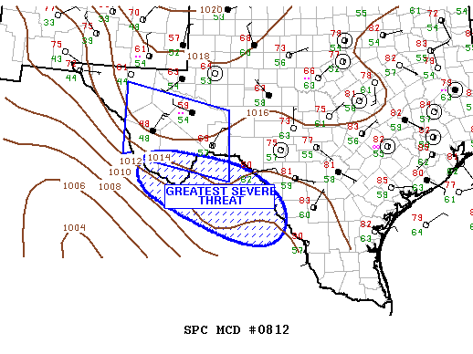
MESOSCALE DISCUSSION 0812
NWS STORM PREDICTION CENTER NORMAN OK
0546 PM CDT MON MAY 14 2012
AREAS AFFECTED...FAR WEST TX INCLUDING THE MIDDLE RIO GRANDE RIVER
VALLEY
CONCERNING...SEVERE THUNDERSTORM WATCH 277...
VALID 142246Z - 142345Z
THE SEVERE WEATHER THREAT FOR SEVERE THUNDERSTORM WATCH 277
CONTINUES.
SUMMARY...STRONG/SEVERE THUNDERSTORMS HAVE MOSTLY SHIFTED SOUTH OF
THE BIG BEND REGION AND WILL REMAIN FOCUSED ACROSS NERN MEXICO FOR
THE NEXT FEW HOURS.
DISCUSSION...LATEST SATELLITE/RADAR IMAGERY CLEARLY DEPICTS CENTER
OF LOW CIRCULATION JUST WEST OF LBB SHIFTING SOUTH IN LINE WITH
SHORT RANGE MODEL GUIDANCE. CONSIDERABLE AMOUNT OF CONVECTION IS
NOTED AHEAD OF THIS FEATURE ACROSS MUCH OF WEST TX AND OVERTURNING
HAS EFFICIENTLY DESTROYED STRONGER INSTABILITY ACROSS ALL BUT
PORTIONS OF SWRN TX FROM THE SRN BALCONES ESCARPMENT INTO NERN
MEXICO. GIVEN THAT STEEPER LAPSE RATES ARE NOW FOCUSED ACROSS NERN
MEXICO IT APPEARS THE STRONGEST STORMS WILL REMAIN SOUTH OF THE
BORDER FOR THE NEXT FEW HOURS. THERE IS SOME CONCERN THAT STRONG
CONVECTION MAY APPROACH THE MIDDLE RIO GRANDE VALLEY LATE AS MID
LEVEL SPEED MAX DIGS TOWARD SOUTH TX.
..DARROW.. 05/14/2012
ATTN...WFO...CRP...EWX...MAF...
0 likes
The following post is NOT an official forecast and should not be used as such. It is just the opinion of the poster and may or may not be backed by sound meteorological data. It is NOT endorsed by any professional institution including storm2k.org For Official Information please refer to the NHC and NWS products.
-
Rgv20
- S2K Supporter
- Posts: 2466
- Age: 39
- Joined: Wed Jan 05, 2011 5:42 pm
- Location: Edinburg/McAllen Tx
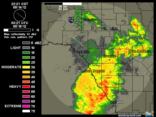
Special Weather Statement
SPECIAL WEATHER STATEMENT
NATIONAL WEATHER SERVICE BROWNSVILLE TX
1036 PM CDT MON MAY 14 2012
TXZ248>257-150600-
ZAPATA-JIM HOGG-BROOKS-KENEDY-STARR-HIDALGO-INLAND WILLACY-
INLAND CAMERON-COASTAL WILLACY-COASTAL CAMERON-
INCLUDING THE CITIES OF...ZAPATA...HEBBRONVILLE...FALFURRIAS...
SARITA...RIO GRANDE CITY...ROMA...MCALLEN...EDINBURG...PHARR...
MISSION...WESLACO...RAYMONDVILLE...BROWNSVILLE...HARLINGEN...
PORT MANSFIELD...PORT ISABEL...SOUTH PADRE ISLAND...
LAGUNA HEIGHTS...LAGUNA VISTA
1036 PM CDT MON MAY 14 2012
...THUNDERSTORMS APPROACHING THE RIO GRANDE VALLEY...
NATIONAL WEATHER SERVICE DOPPLER RADAR IN BROWNSVILLE IS TRACKING
NUMEROUS THUNDERSTORMS LOCATED OVER COAHUILA AND NUEVO LEON STATE
IN NEIGHBORING MEXICO. MOVEMENT OF THESE THUNDERSTORMS IS TO THE
SOUTHEAST AT AROUND 40 MPH.
THE THUNDERSTORMS WILL LIKELY AFFECT ZAPATA...STARR...AND JIM HOGG
COUNTY AROUND MIDNIGHT TONIGHT...BROOKS AND HIDALGO COUNTY NEAR 2
AM CDT...AND CAMERON...WILLACY...AND KENEDY COUNTY NEAR 4 AM CDT.
FREQUENT LIGHTNING...WIND GUSTS OF 40 TO 50 MPH...AND PEA-SIZE HAIL
WILL BE THE MAIN THREATS WITH THESE THUNDERSTORMS AS THEY MOVE
OVER THE RIO GRANDE VALLEY AND DEEP SOUTH TEXAS THROUGH THE NEXT
SEVERAL HOURS.
$$
TOMASELLI/STRAUB/CACERES
0 likes
The following post is NOT an official forecast and should not be used as such. It is just the opinion of the poster and may or may not be backed by sound meteorological data. It is NOT endorsed by any professional institution including storm2k.org For Official Information please refer to the NHC and NWS products.
-
horselattitudesfarm

- Category 1

- Posts: 315
- Joined: Thu Jul 16, 2009 5:55 pm
- Location: Asheville, NC (formerly from Dallas, TX)
Re: Texas Spring 2012
Portastorm wrote:All kidding aside, it seemed like the Corpus NWS office was issuing a tornado warning or severe t-storm warning every 10 minutes on that day (May 10). Y'all certainly had your hands full. Glad the cctx compound didn't endure too much damage.
Interesting news about how Mother Nature has pruned your trees. Hope she's not preparing you for something "bigger" this summer.
I keep thinking how amazing it is . . . how different this spring has been weatherwise in Texas than last year. Really, it seems like it has been several years at least when we have seen this amount of rain/storms.
I'm glad your spring is different. Same ole thing up here in North Texas....Hot and dry. Look at this:.....Uh....well, all I get from image shack is "You must provide a valid auth token or dev key. see http://code.google.com/p/imageshackapi/ ". So I cannot download the image. Anyone know how to get this thing to work
0 likes

I'm happy for south and central Texas, such a blessing. I wouldn't say it's been hot in north Texas warm yes, only touched 90 once or twice all spring and last week was cool compared to average which is amazing if you think about it. Dry, definitely haven't had the rain like in other parts of the state except scattered, grass is turning slightly yellow now though. Still a very far cry from one year ago. There might be a small disturbance next week at some point but may stay in northeast Texas. Don't see any major outbreaks of tornadoes still so that's good. There are signs the PNA might go negative again end of the month so expect summer to start soon.
0 likes
The above post and any post by Ntxw is NOT an official forecast and should not be used as such. It is just the opinion of the poster and may or may not be backed by sound meteorological data. It is NOT endorsed by any professional institution including Storm2k. For official information, please refer to NWS products.
Help support Storm2K!
-
weatherdude1108
- Category 5
- Posts: 4228
- Joined: Tue Dec 13, 2011 1:04 pm
- Location: Northwest Austin/Cedar Park, TX
Re:
Ntxw wrote:I'm happy for south and central Texas, such a blessing. I wouldn't say it's been hot in north Texas warm yes, only touched 90 once or twice all spring and last week was cool compared to average which is amazing if you think about it. Dry, definitely haven't had the rain like in other parts of the state except scattered, grass is turning slightly yellow now though. Still a very far cry from one year ago. There might be a small disturbance next week at some point but may stay in northeast Texas. Don't see any major outbreaks of tornadoes still so that's good. There are signs the PNA might go negative again end of the month so expect summer to start soon.
What does the PNA do again, and what does it mean for Texas weather? When someone brings up the AO, PNA, MJO, etc. and how they change, I get confused. Trying to figure out the correlation and what to expect in Texas based on what they do and interact. Do they effect La Ninas/El Ninos? I'm always trying to see a hint into the future of the next rain event, since it appears the "flowing faucet" that has been so nice lately will be shutting off for the time being.
0 likes
-
weatherdude1108
- Category 5
- Posts: 4228
- Joined: Tue Dec 13, 2011 1:04 pm
- Location: Northwest Austin/Cedar Park, TX
Bob Rose thinks there will be more opportunity for storms in Central Texas from May going through the month of June in his video blog.
http://www.lcra.org/water/conditions/we ... olumn.html
http://www.lcra.org/water/conditions/we ... olumn.html
0 likes
The preceding post is NOT an official forecast, and should not be used as such. It is only the opinion of the poster and may or may not be backed by sound meteorological data. It is NOT endorsed by any professional institution including storm2k.org. For Official Information please refer to the NHC and NWS products.
Re: Re:
weatherdude1108 wrote:What does the PNA do again, and what does it mean for Texas weather?
A -PNA is when troughing happens in the west coast (+PNA is opposite of that). As a result ridging is likely over Texas therefore storms travel well to the north and we are warm and dry in a -PNA pattern. Not sure the exact correlation but I think El Nino's tend to favor +PNA patterns. I think rainfall chances will likely come from the tropics if we are to break the warm/dry result of the -PNA.
0 likes
The above post and any post by Ntxw is NOT an official forecast and should not be used as such. It is just the opinion of the poster and may or may not be backed by sound meteorological data. It is NOT endorsed by any professional institution including Storm2k. For official information, please refer to NWS products.
Help support Storm2K!
Help support Storm2K!
-
weatherdude1108
- Category 5
- Posts: 4228
- Joined: Tue Dec 13, 2011 1:04 pm
- Location: Northwest Austin/Cedar Park, TX
How the tables turn overnight in Bob's written blog the next day (May 16, 2012). Hmmm.  No real chance of rain the rest of the month of May. Now that the Colorado River system is primed for runoff, the rain shuts off for who knows how long.
 That is what happened from March going into April. The basin was primed, then it didn't rain for a month or so. When the rain came back, the first few inches soaked into ground before running off. Maybe we'll get a few MCSs coming in from NW Texas. Otherwise, the doldrums have returned. Hmmm.
0 likes
The preceding post is NOT an official forecast, and should not be used as such. It is only the opinion of the poster and may or may not be backed by sound meteorological data. It is NOT endorsed by any professional institution including storm2k.org. For Official Information please refer to the NHC and NWS products.
-
somethingfunny

- ChatStaff

- Posts: 3926
- Age: 37
- Joined: Thu May 31, 2007 10:30 pm
- Location: McKinney, Texas
Re: Texas Spring 2012
Holy crap!

We're still dry, but the D4 is almost gone!
Remember this?
We're still dry, but the D4 is almost gone!
Remember this?
somethingfunny wrote:Still improving over last week, but the rate of improvement is slowing down. Most of the gains are in the Panhandle, I imagine.
I'm starting to feel rain deprived too - but May is normally our wettest month, so we'll have to see what comes together.

0 likes
I am not a meteorologist, and any posts made by me are not official forecasts or to be interpreted as being intelligent. These posts are just my opinions and are probably silly opinions.
-
horselattitudesfarm
- Category 1
- Posts: 315
- Joined: Thu Jul 16, 2009 5:55 pm
- Location: Asheville, NC (formerly from Dallas, TX)
Re: Texas Spring 2012
somethingfunny wrote:Holy crap!
We're still dry, but the D4 is almost gone!
Remember this?somethingfunny wrote:Still improving over last week, but the rate of improvement is slowing down. Most of the gains are in the Panhandle, I imagine.
If you look, D0 is actually growing in East Texas. I imagine by next week it will be growing even faster and will start covering N. Tx. also.
I'm starting to feel rain deprived too - but May is normally our wettest month, so we'll have to see what comes together.
0 likes
-
Portastorm
- Storm2k Moderator
- Posts: 9955
- Age: 63
- Joined: Fri Jul 11, 2003 9:16 am
- Location: Round Rock, TX
- Contact:
Re:
weatherdude1108 wrote:How the tables turn overnight in Bob's written blog the next day (May 16, 2012). Hmmm.
I don't know about that. With an ENSO neutral summer, we won't see any particular type of weather hanging around persistently. Should be one of the more variable summers we have seen in a few years.
0 likes
Any forecasts under my name are to be taken with a grain of salt. Get your best forecasts from the National Weather Service and National Hurricane Center.
-
Texas Snowman

- Storm2k Moderator
- Posts: 6197
- Joined: Fri Jan 25, 2008 11:29 am
- Location: Denison, Texas
Re: Re:
Portastorm wrote:weatherdude1108 wrote:How the tables turn overnight in Bob's written blog the next day (May 16, 2012). Hmmm.
I don't know about that. With an ENSO neutral summer, we won't see any particular type of weather hanging around persistently. Should be one of the more variable summers we have seen in a few years.
After last year's horrendous summer, I can understand the gnashing of teeth I'm starting to see here. But there's no point in stressing about it. And especially since a great portion of the state is in MUCH better shape than it was a year ago, and in many cases, remarkably better shape than a year ago.
June is just around the corner and after 30+ years of observing Texas weather, that means hot and little in the way of rainfall unless there is tropical interference. It's just the nature of living here. I read once that generally speaking, starting at the Texas/Louisiana line and moving westward through the state, you lose one-inch of rainfall annually for every 10-20 miles that you travel. There are reasons for that and those reasons exert themselves fully in June, July, and August.
The Gulf is very warm, the waters off SW Mexico are warm, and I suspect there will be some close, home-brew type of systems early in the tropical season that will influence our weather. After that, we may have to wait and see if we get a Cape Verde type of system trying to track towards the state in August, September.
0 likes
The above post and any post by Texas Snowman is NOT an official forecast and should not be used as such. It is just the opinion of the poster and may or may not be backed by sound meteorological data. It is NOT endorsed by any professional institution including storm2k.org. For official information, please refer to NWS products.
-
aggiecutter
- Category 5
- Posts: 1755
- Joined: Thu Oct 14, 2004 9:22 pm
- Location: Texarkana
Re: Texas Spring 2012
Texarkana had 2" plus surplus of rainfall for the year going into the month of May. Since May 1st, we have had .50" of rain. Not good, considering May is normally our wettest month. There is a 30% chance of rain tomorrow. However, that probably won't amount to much. According to the latest models, the next chance for significant rain won't be until the end of the month, if then.
On a more sobering note, here is footage from St. Johns Hospital emergency room as it was being hit by the May 22nd F5 Joplin tornado from last year.
http://www.youtube.com/watch?feature=pl ... gKzq58UMNM
On a more sobering note, here is footage from St. Johns Hospital emergency room as it was being hit by the May 22nd F5 Joplin tornado from last year.
http://www.youtube.com/watch?feature=pl ... gKzq58UMNM
0 likes
-
Texas Snowman
- Storm2k Moderator
- Posts: 6197
- Joined: Fri Jan 25, 2008 11:29 am
- Location: Denison, Texas
Interesting tweet from Joe B:
@BigJoeBastardi: "Dont understand SPC day 4-8 . There should be moderate to major tornado outbreak this week in plains."
@BigJoeBastardi: "Dont understand SPC day 4-8 . There should be moderate to major tornado outbreak this week in plains."
0 likes
The above post and any post by Texas Snowman is NOT an official forecast and should not be used as such. It is just the opinion of the poster and may or may not be backed by sound meteorological data. It is NOT endorsed by any professional institution including storm2k.org. For official information, please refer to NWS products.
-
weatherdude1108
- Category 5
- Posts: 4228
- Joined: Tue Dec 13, 2011 1:04 pm
- Location: Northwest Austin/Cedar Park, TX
Just what I wanted to see!
Maybe next time.
.PREV DISCUSSION... /ISSUED 400 AM CDT TUE MAY 22 2012/
DISCUSSION...
EARLY THIS MORNING..AN UPPER LEVEL RIDGE REMAINS OVER NORTHEASTERN
MEXICO WITH A NORTHWESTERLY FLOW ALOFT OVER SOUTH CENTRAL TEXAS
WHILE A WEAK SURFACE BOUNDARY IS ACROSS EASTERN TEXAS. HI-RES
MODELS SHOW A FEW SHOWERS AND THUNDERSTORMS DEVELOPING ALONG THIS
BOUNDARY DUE TO MOISTURE CONVERGENCE...WEAK INSTABILITY AND SOLAR
HEATING. STEERING FLOW WILL KEEP THESE AWAY FROM SOUTH CENTRAL
TEXAS AND HAVE REMOVED POPS WHERE PREVIOUSLY MENTIONED. THE UPPER
LEVEL RIDGE MOVES ACROSS TEXAS WEDNESDAY INTO FRIDAY AND THEN
BUILDS AND EXPANDS OVER THE SOUTHEASTERN STATES OVER THE MEMORIAL
DAY WEEKEND INTO MONDAY AS AN UPPER LEVEL TROUGH DEEPENS OVER THE
WESTERN STATES. TEMPERATURES SLOWLY WARM THROUGH THE REMAINDER OF
THE WEEK. SOUTHERLY LOWER LEVEL FLOW STRENGTHENS INCREASING LOWER
LEVEL MOISTURE MAKING IT FEEL MORE HUMID. HAVE GONE ONLY SLIGHTLY
ABOVE GUIDANCE HIGHS AS SOIL MOISTURE FROM RECENT RAINS STILL A
FACTOR IN DAYTIME TEMPERATURES. OVER THE MEMORIAL DAY WEEKEND...
DEEPER MOISTURE FROM THE TROPICS MOVES INTO SOUTHERN TEXAS. THE
PREVIOUSLY CONSISTENT MODELS ARE NOW SHOWING AN EXTENSION OF THE
UPPER LEVEL RIDGE FROM THE SOUTHEASTERN STATES AND LESS RAINFALL
POTENTIAL ACROSS SOUTH CENTRAL TEXAS SHIFTING IT TOWARD THE RIO
GRANDE. ALSO...THE MODELS ARE NOW SHOWING LITTLE OR NO IMPACT OF
EASTERN PACIFIC TROPICAL SYSTEM BUD ON SOUTH CENTRAL TEXAS. FOR
NOW...WILL MAINTAIN SLIGHT CHANCE POPS FOR THE SOUTHWESTERN HALF
OF SOUTH CENTRAL TEXAS WITH THE HIGHEST POPS ALONG THE RIO GRANDE
SATURDAY AND SUNDAY. DAYTIME TEMPERATURES MAY COOL A LITTLE DUE TO
THE INCREASED CLOUDS OVER THE WEEKEND.
0 likes
The preceding post is NOT an official forecast, and should not be used as such. It is only the opinion of the poster and may or may not be backed by sound meteorological data. It is NOT endorsed by any professional institution including storm2k.org. For Official Information please refer to the NHC and NWS products.
Return to “USA & Caribbean Weather”
Who is online
Users browsing this forum: CaptinCrunch and 82 guests