ATL: ALBERTO - Post-Tropical

Moderator: S2k Moderators

Message
Author
ozonepete
Professional-Met
Professional-Met
Posts: 4743
Joined: Mon Sep 07, 2009 3:23 pm
Location: From Ozone Park, NYC / Now in Brooklyn, NY

Re: ATL: ALBERTO - Tropical Storm

#281 Postby ozonepete » Sat May 19, 2012 10:26 pm

tolakram wrote:Wind shear picking up as well.


Hi Mark. No the shear isn't picking up. Your map is current shear, not forecast. Look at the CIMSS shear tendency map. Shear is decreasing or stable over most of the system. It's only increasing to the southeast, and Alberto isn't headed that way.


Image
0 likes   

ozonepete
Professional-Met
Professional-Met
Posts: 4743
Joined: Mon Sep 07, 2009 3:23 pm
Location: From Ozone Park, NYC / Now in Brooklyn, NY

Re: ATL: ALBERTO - Tropical Storm

#282 Postby ozonepete » Sat May 19, 2012 10:33 pm

SouthDadeFish wrote:Well then it is one strong tilt :D You may very well be correct, I just think the jet to the S of Alberto is starting to make itself known on Alberto's circulation. The thing that would leave me optimistic is that radar presentation is still decent.


LOL. Yeah that is one hell of a tilt. :lol: And that jet is key. But right now the CIMSS analysis and other synoptic analyses (and looking at the satellite loops) indicate that the jet is actually moving away. That is why Alberto is forecast to not move much, and also why the shear from that jet may not have much effect over the next few days. But is is a really close call. I'm more concerned that it will ingest some of that mid-level dry air to the north and west. It wouldn't take much of an ingestion at all to completely collapse the remaining thunderstorms for good.
0 likes   

tolakram
Admin
Admin
Posts: 20009
Age: 62
Joined: Sun Aug 27, 2006 8:23 pm
Location: Florence, KY (name is Mark)

Re: ATL: ALBERTO - Tropical Storm

#283 Postby tolakram » Sat May 19, 2012 10:58 pm

ozonepete wrote:
tolakram wrote:Wind shear picking up as well.


Hi Mark. No the shear isn't picking up. Your map is current shear, not forecast. Look at the CIMSS shear tendency map. Shear is decreasing or stable over most of the system. It's only increasing to the southeast, and Alberto isn't headed that way.


Image


I love the shear tendency map for the colors, but don't get burned by the increasing / decreasing lines.

http://tropic.ssec.wisc.edu/real-time/w ... oom=&time=

Use the -3 hr to step back trough the maps. Notice how, when Alberto formed, the shear near the center was less than now. Shear has been trending stronger throughout the day, though I agree that in the last 3 hours it may have dropped a bit, which creates the decreasing lines.

My guess is that shear is about to increase to the 40 - 60 kt range based on the red areas slowly inching north.

Personal Forecast Disclaimer:
The posts in this forum are NOT official forecast and should not be used as such. They are just the opinion of the poster and may or may not be backed by sound meteorological data. They are NOT endorsed by any professional institution or storm2k.org. For official information, please refer to the NHC and NWS products.
0 likes   
M a r k
- - - - -
Join us in chat: Storm2K Chatroom Invite. Android and IOS apps also available.

The posts in this forum are NOT official forecasts and should not be used as such. Posts are NOT endorsed by any professional institution or STORM2K.org. For official information and forecasts, please refer to NHC and NWS products.

ozonepete
Professional-Met
Professional-Met
Posts: 4743
Joined: Mon Sep 07, 2009 3:23 pm
Location: From Ozone Park, NYC / Now in Brooklyn, NY

Re: ATL: ALBERTO - Tropical Storm

#284 Postby ozonepete » Sat May 19, 2012 11:17 pm

[quote="tolakram"]Use the -3 hr to step back trough the maps. Notice how, when Alberto formed, the shear near the center was less than now. Shear has been trending stronger throughout the day, though I agree that in the last 3 hours it may have dropped a bit, which creates the decreasing lines. [quote]

Heh heh. Yes, actually neither chart tells us what we want to know. The current shear map is only good if you do what you do and look back at previous maps to see how it's been changing recently. But that doesn't tell you how it WILL change in the future. The shear tendency chart I showed is actually the same thing - a chart of how shear has trended up til the current hour. That also doesn't tell you how it will change from here on. I don't have time to post them but the Penn State tropical e-wall shear forecast charts and the SHIPS forecasts are better tools. But of course shear forecasting is still really awful - one of the worst performers of any forecast aspect we have to worry about. All of us here on Storm2K know that. :roll:
0 likes   

tolakram
Admin
Admin
Posts: 20009
Age: 62
Joined: Sun Aug 27, 2006 8:23 pm
Location: Florence, KY (name is Mark)

Re: ATL: ALBERTO - Tropical Storm

#285 Postby tolakram » Sat May 19, 2012 11:40 pm

A new burst appearing near the center. Perhaps another shot before shear increases (if it does).
0 likes   
M a r k
- - - - -
Join us in chat: Storm2K Chatroom Invite. Android and IOS apps also available.

The posts in this forum are NOT official forecasts and should not be used as such. Posts are NOT endorsed by any professional institution or STORM2K.org. For official information and forecasts, please refer to NHC and NWS products.

tolakram
Admin
Admin
Posts: 20009
Age: 62
Joined: Sun Aug 27, 2006 8:23 pm
Location: Florence, KY (name is Mark)

Re: ATL: ALBERTO - Tropical Storm

#286 Postby tolakram » Sun May 20, 2012 12:48 am

Burst is continuing, center tucked under at the moment.

Image

Image

Live IR loop: http://wwwghcc.msfc.nasa.gov/cgi-bin/ge ... =spect.pal
0 likes   
M a r k
- - - - -
Join us in chat: Storm2K Chatroom Invite. Android and IOS apps also available.

The posts in this forum are NOT official forecasts and should not be used as such. Posts are NOT endorsed by any professional institution or STORM2K.org. For official information and forecasts, please refer to NHC and NWS products.

JonathanBelles
Professional-Met
Professional-Met
Posts: 11430
Age: 35
Joined: Sat Dec 24, 2005 9:00 pm
Location: School: Florida State University (Tallahassee, FL) Home: St. Petersburg, Florida
Contact:

Re: ATL: ALBERTO - Tropical Storm

#287 Postby JonathanBelles » Sun May 20, 2012 1:42 am

The posts in this forum are NOT official forecast and should not be used as such. They are just the opinion of the poster and may or may not be backed by sound meteorological data. They are NOT endorsed by any professional institution or storm2k.org. For official information, please refer to the NHC and NWS products.

An update on Tropical Storm Alberto...entering diurnal maximum:

http://jonathanbelles.wordpress.com/201 ... to-update/
0 likes   

ozonepete
Professional-Met
Professional-Met
Posts: 4743
Joined: Mon Sep 07, 2009 3:23 pm
Location: From Ozone Park, NYC / Now in Brooklyn, NY

Re: ATL: ALBERTO - Tropical Storm

#288 Postby ozonepete » Sun May 20, 2012 3:25 am

Shear is dropping. The main threat is definitely the dry air, although that may ease up soon. Dewpoints are going up a little bit within the general circulation envelope. Here's the latest SPC analysis; so far the dry air is not getting pulled into the core yet. Still, these are very low dewpoints for a TC on average.

:Image

Image
0 likes   

bamajammer4eva
Category 4
Category 4
Posts: 907
Joined: Sun Apr 18, 2010 3:21 am
Location: Ozark, AL

Re: ATL: ALBERTO - Tropical Storm

#289 Postby bamajammer4eva » Sun May 20, 2012 3:41 am

2 am + 5 am position and the latest radar out of Charleston.

Image
0 likes   

User avatar
ouragans
Category 1
Category 1
Posts: 490
Age: 53
Joined: Sun Jun 12, 2011 12:09 pm
Location: Abymes, Guadeloupe F.W.I
Contact:

Re: ATL: ALBERTO - Advisories

#290 Postby ouragans » Sun May 20, 2012 5:20 am

TROPICAL STORM ALBERTO FORECAST/ADVISORY NUMBER 3
NWS NATIONAL HURRICANE CENTER MIAMI FL AL012012
0900 UTC SUN MAY 20 2012

CHANGES IN WATCHES AND WARNINGS WITH THIS ADVISORY...

NONE.

SUMMARY OF WATCHES AND WARNINGS IN EFFECT...

A TROPICAL STORM WATCH IS IN EFFECT FOR...
* SAVANNAH RIVER TO SOUTH SANTEE RIVER SOUTH CAROLINA

A TROPICAL STORM WATCH MEANS THAT TROPICAL STORM CONDITIONS ARE
POSSIBLE WITHIN THE WATCH AREA...IN THIS CASE WITHIN 24 HOURS.

COASTAL INTERESTS ELSEWHERE FROM GEORGIA THROUGH THE OUTER BANKS OF
NORTH CAROLINA SHOULD MONITOR THE PROGRESS OF ALBERTO.

TROPICAL STORM CENTER LOCATED NEAR 31.7N 78.9W AT 20/0900Z
POSITION ACCURATE WITHIN 20 NM

PRESENT MOVEMENT TOWARD THE WEST-SOUTHWEST OR 245 DEGREES AT 5 KT

ESTIMATED MINIMUM CENTRAL PRESSURE 998 MB
MAX SUSTAINED WINDS 45 KT WITH GUSTS TO 55 KT.
34 KT....... 40NE 0SE 0SW 60NW.
12 FT SEAS.. 80NE 40SE 60SW 40NW.
WINDS AND SEAS VARY GREATLY IN EACH QUADRANT. RADII IN NAUTICAL
MILES ARE THE LARGEST RADII EXPECTED ANYWHERE IN THAT QUADRANT.

REPEAT...CENTER LOCATED NEAR 31.7N 78.9W AT 20/0900Z
AT 20/0600Z CENTER WAS LOCATED NEAR 31.8N 78.7W

FORECAST VALID 20/1800Z 31.4N 79.3W
MAX WIND 45 KT...GUSTS 55 KT.
34 KT... 40NE 20SE 20SW 60NW.

FORECAST VALID 21/0600Z 31.2N 79.5W
MAX WIND 45 KT...GUSTS 55 KT.
34 KT... 40NE 20SE 20SW 60NW.

FORECAST VALID 21/1800Z 31.6N 78.8W
MAX WIND 45 KT...GUSTS 55 KT.
34 KT... 50NE 30SE 30SW 40NW.

FORECAST VALID 22/0600Z 32.8N 77.1W
MAX WIND 45 KT...GUSTS 55 KT.
34 KT... 50NE 30SE 30SW 30NW.

FORECAST VALID 23/0600Z 36.2N 72.6W...POST-TROPICAL
MAX WIND 40 KT...GUSTS 50 KT.
34 KT... 60NE 50SE 40SW 40NW.

EXTENDED OUTLOOK. NOTE...ERRORS FOR TRACK HAVE AVERAGED NEAR 175 NM
ON DAY 4 AND 225 NM ON DAY 5...AND FOR INTENSITY NEAR 20 KT EACH DAY

OUTLOOK VALID 24/0600Z 39.0N 68.5W...POST-TROPICAL
MAX WIND 35 KT...GUSTS 45 KT.

OUTLOOK VALID 25/0600Z...DISSIPATED

REQUEST FOR 3 HOURLY SHIP REPORTS WITHIN 300 MILES OF 31.7N 78.9W

NEXT ADVISORY AT 20/1500Z

$$
FORECASTER CANGIALOSI/BROWN


TROPICAL STORM ALBERTO ADVISORY NUMBER 3
NWS NATIONAL HURRICANE CENTER MIAMI FL AL012012
500 AM EDT SUN MAY 20 2012

...ALBERTO CHANGES LITTLE IN STRENGTH...


SUMMARY OF 500 AM EDT...0900 UTC...INFORMATION
----------------------------------------------
LOCATION...31.7N 78.9W
ABOUT 100 MI...160 KM SE OF CHARLESTON SOUTH CAROLINA
ABOUT 130 MI...210 KM ESE OF SAVANNAH GEORGIA
MAXIMUM SUSTAINED WINDS...50 MPH...85 KM/H
PRESENT MOVEMENT...WSW OR 245 DEGREES AT 6 MPH...9 KM/H
MINIMUM CENTRAL PRESSURE...998 MB...29.47 INCHES


WATCHES AND WARNINGS
--------------------
CHANGES WITH THIS ADVISORY...

NONE.

SUMMARY OF WATCHES AND WARNINGS IN EFFECT...

A TROPICAL STORM WATCH IS IN EFFECT FOR...
* SAVANNAH RIVER TO SOUTH SANTEE RIVER SOUTH CAROLINA

A TROPICAL STORM WATCH MEANS THAT TROPICAL STORM CONDITIONS ARE
POSSIBLE WITHIN THE WATCH AREA...IN THIS CASE WITHIN 24 HOURS.

COASTAL INTERESTS ELSEWHERE FROM GEORGIA THROUGH THE OUTER BANKS OF
NORTH CAROLINA SHOULD MONITOR THE PROGRESS OF ALBERTO.

FOR STORM INFORMATION SPECIFIC TO YOUR AREA...INCLUDING POSSIBLE
INLAND WATCHES AND WARNINGS...PLEASE MONITOR PRODUCTS ISSUED BY
YOUR LOCAL NATIONAL WEATHER SERVICE FORECAST OFFICE.


DISCUSSION AND 48-HOUR OUTLOOK
------------------------------
AT 500 AM EDT...0900 UTC...THE CENTER OF TROPICAL STORM ALBERTO WAS
LOCATED NEAR LATITUDE 31.7 NORTH...LONGITUDE 78.9 WEST. ALBERTO IS
MOVING TOWARD THE WEST-SOUTHWEST NEAR 6 MPH...9 KM/H...AND THIS
GENERAL MOTION WITH A DECREASE IN FORWARD SPEED IS EXPECTED TODAY.
A TURN TOWARD THE NORTHEAST IS FORECAST ON MONDAY.

MAXIMUM SUSTAINED WINDS REMAIN NEAR 50 MPH...85 KM/H...WITH HIGHER
GUSTS. LITTLE CHANGE IN STRENGTH IS FORECAST DURING THE NEXT 48
HOURS.

TROPICAL STORM FORCE WINDS EXTEND OUTWARD UP TO 70 MILES...110 KM
FROM THE CENTER.

ESTIMATED MINIMUM CENTRAL PRESSURE IS 998 MB...29.47 INCHES.


HAZARDS AFFECTING LAND
----------------------
WIND...TROPICAL STORM CONDITIONS ARE POSSIBLE ALONG THE COAST OF
SOUTH CAROLINA IN THE WATCH AREA LATER TODAY OR MONDAY.

SURF...DANGEROUS SURF CONDITIONS ARE POSSIBLE ALONG THE COASTS OF
GEORGIA AND SOUTH CAROLINA THROUGH MONDAY. PLEASE SEE STATEMENTS
ISSUED BY YOUR LOCAL NATIONAL WEATHER SERVICE OFFICE FOR
INFORMATION SPECIFIC TO YOUR AREA.


NEXT ADVISORY
-------------
NEXT INTERMEDIATE ADVISORY...800 AM EDT.
NEXT COMPLETE ADVISORY...1100 AM EDT.

$$
FORECASTER CANGIALOSI/BROWN

TROPICAL STORM ALBERTO DISCUSSION NUMBER 3
NWS NATIONAL HURRICANE CENTER MIAMI FL AL012012
500 AM EDT SUN MAY 20 2012

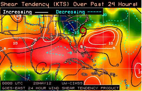
ALBERTO APPEARS TO BE MAINTAINING ITS STRENGTH. SATELLITE AND RADAR
IMAGES SHOW THAT DEEP CONVECTION REFORMED NEAR THE CENTER OF THE
TROPICAL STORM OVERNIGHT WITH A BROKEN BAND OF THUNDERSTORM
ACTIVITY REMAINING TO THE NORTH OF THE CENTER. AN ASCAT PASS AROUND
0300 UTC SHOWED MAXIMUM WINDS NEAR 40 KT. BASED ON THE
SCATTEROMETER DATA AND THE RECENT INCREASE IN THUNDERSTORM
ACTIVITY...THE INITIAL INTENSITY IS HELD AT 45 KT. ALTHOUGH ALBERTO
LIES OVER THE RELATIVELY WARM WATERS OF THE GULF STREAM...DRY AIR
IN THE VICINITY OF THE CYCLONE AND STRONG WEST-SOUTHWESTERLY SHEAR
SHOULD LIMIT THE INTENSIFICATION PROCESS. THE OFFICIAL INTENSITY
FORECAST IS SIMILAR TO THE PREVIOUS ONE AND SHOWS ALBERTO REMAINING
STEADY STATE FOR THE NEXT COUPLE OF DAYS. WEAKENING AND A
TRANSITION TO A POST-TROPICAL CYCLONE IS FORECAST BEYOND THAT TIME
WHEN ALBERTO MOVES OVER COOLER WATERS AND INTO AN AREA OF VERY
STRONG UPPER-LEVEL WINDS.

ALBERTO IS CURRENTLY MOVING WEST-SOUTHWESTWARD AT ABOUT 5 KT. THIS
GENERAL HEADING WITH A DECREASE IN FORWARD SPEED IS EXPECTED TODAY
AS A DEEP-LAYER RIDGE OVER THE EASTERN UNITED STATES WEAKENS. THE
TROPICAL CYCLONE IS EXPECTED TO STALL OFF THE SOUTHEAST UNITED
STATES COAST TONIGHT AND EARLY MONDAY AS IT INTERACTIONS WITH AN
AREA OF LOW PRESSURE TO ITS NORTH NEAR THE MID-ATLANTIC STATES AND
A DEVELOPING LOW TO ITS SOUTHEAST. THEREAFTER...A MID-TO
UPPER-LEVEL TROUGH MOVING ACROSS THE EASTERN UNITED STATES SHOULD
CAUSE ALBERTO...OR ITS POST-TROPICAL REMNANTS...TO ACCELERATE
NORTHEASTWARD OVER THE WESTERN ATLANTIC. THE OFFICIAL TRACK
FORECAST HAS BEEN ADJUSTED SLIGHTLY EASTWARD TO BE IN BETTER
AGREEMENT WITH THE LATEST GUIDANCE. FUTURE ADJUSTMENTS IN THAT
DIRECTION MAY BE NECESSARY IF THE RECENT MODEL TRENDS CONTINUE.

FORECAST POSITIONS AND MAX WINDS

INIT 20/0900Z 31.7N 78.9W 45 KT 50 MPH
12H 20/1800Z 31.4N 79.3W 45 KT 50 MPH
24H 21/0600Z 31.2N 79.5W 45 KT 50 MPH
36H 21/1800Z 31.6N 78.8W 45 KT 50 MPH
48H 22/0600Z 32.8N 77.1W 45 KT 50 MPH
72H 23/0600Z 36.2N 72.6W 40 KT 45 MPH...POST-TROPICAL
96H 24/0600Z 39.0N 68.5W 35 KT 40 MPH...POST-TROPICAL
120H 25/0600Z...DISSIPATED

$$
FORECASTER CANGIALOSI/BROWN
0 likes   
Personal forecast disclaimer
This post is a personal point of view, not an information. Please refer to official statements for life-threatening decisions.

David '79, Frederic '79, Hugo '89, Iris, Luis & Marilyn '95, Georges '98, Lenny '99, Dean '07, Irma '17, Maria '17, Fiona '22, Philippe '23, Tammy '23
16°13'33.3,"6N -61°36'39.5"W

User avatar
GCANE
S2K Supporter
S2K Supporter
Posts: 11496
Joined: Mon Oct 22, 2007 8:03 am

Re: ATL: ALBERTO - Tropical Storm

#291 Postby GCANE » Sun May 20, 2012 5:29 am

Been watching SPC Meso Analysis last few hours and looks like CAPE increasing on north side of the LLC.

Bascially, thuderstorms getting a good infeed of unstable air.

Waiting for VIS sat to see if there are overshooting tops.

http://www.spc.noaa.gov/exper/mesoanaly ... sector=17#
0 likes   

User avatar
GCANE
S2K Supporter
S2K Supporter
Posts: 11496
Joined: Mon Oct 22, 2007 8:03 am

Re: ATL: ALBERTO - Tropical Storm

#292 Postby GCANE » Sun May 20, 2012 6:13 am

A couple small OTs at the LLC and 3 small OTs to the north.

Could see a bit of a core temp increase as a result.

http://www.spc.noaa.gov/exper/mesoanaly ... 7512309193

http://www.ssd.noaa.gov/PS/TROP/floater ... 0-lalo.jpg
0 likes   

User avatar
cycloneye
Admin
Admin
Posts: 145296
Age: 68
Joined: Thu Oct 10, 2002 10:54 am
Location: San Juan, Puerto Rico

Re: ATL: ALBERTO - Advisories

#293 Postby cycloneye » Sun May 20, 2012 6:41 am

BULLETIN
TROPICAL STORM ALBERTO INTERMEDIATE ADVISORY NUMBER 3A
NWS NATIONAL HURRICANE CENTER MIAMI FL AL012012
800 AM EDT SUN MAY 20 2012

...ALBERTO MOVING SLOWLY WEST-SOUTHWESTWARD...NOT EXPECTED TO
STRENGTHEN...


SUMMARY OF 800 AM EDT...1200 UTC...INFORMATION
----------------------------------------------
LOCATION...31.7N 79.3W
ABOUT 95 MI...150 KM SSE OF CHARLESTON SOUTH CAROLINA
ABOUT 115 MI...185 KM ESE OF SAVANNAH GEORGIA
MAXIMUM SUSTAINED WINDS...50 MPH...85 KM/H
PRESENT MOVEMENT...WSW OR 245 DEGREES AT 6 MPH...9 KM/H
MINIMUM CENTRAL PRESSURE...998 MB...29.47 INCHES


WATCHES AND WARNINGS
--------------------
CHANGES WITH THIS ADVISORY...

NONE.

SUMMARY OF WATCHES AND WARNINGS IN EFFECT...

A TROPICAL STORM WATCH IS IN EFFECT FOR...
* SAVANNAH RIVER TO SOUTH SANTEE RIVER SOUTH CAROLINA

A TROPICAL STORM WATCH MEANS THAT TROPICAL STORM CONDITIONS ARE
POSSIBLE WITHIN THE WATCH AREA...IN THIS CASE WITHIN 24 HOURS.

COASTAL INTERESTS ELSEWHERE FROM GEORGIA THROUGH THE OUTER BANKS OF
NORTH CAROLINA SHOULD MONITOR THE PROGRESS OF ALBERTO.

FOR STORM INFORMATION SPECIFIC TO YOUR AREA...INCLUDING POSSIBLE
INLAND WATCHES AND WARNINGS...PLEASE MONITOR PRODUCTS ISSUED BY
YOUR LOCAL NATIONAL WEATHER SERVICE FORECAST OFFICE.


DISCUSSION AND 48-HOUR OUTLOOK
------------------------------
AT 800 AM EDT...1200 UTC...THE CENTER OF TROPICAL STORM ALBERTO WAS
LOCATED NEAR LATITUDE 31.7 NORTH...LONGITUDE 79.3 WEST. ALBERTO IS
MOVING TOWARD THE WEST-SOUTHWEST NEAR 6 MPH...9 KM/H...AND THIS
GENERAL MOTION WITH A DECREASE IN FORWARD SPEED IS EXPECTED TODAY.
A TURN TOWARD THE NORTHEAST IS FORECAST ON MONDAY.

MAXIMUM SUSTAINED WINDS REMAIN NEAR 50 MPH...85 KM/H...WITH HIGHER
GUSTS. LITTLE CHANGE IN STRENGTH IS FORECAST DURING THE NEXT 48
HOURS.

TROPICAL STORM FORCE WINDS EXTEND OUTWARD UP TO 70 MILES...110 KM
FROM THE CENTER.

ESTIMATED MINIMUM CENTRAL PRESSURE IS 998 MB...29.47 INCHES.


HAZARDS AFFECTING LAND
----------------------
WIND...TROPICAL STORM CONDITIONS ARE POSSIBLE ALONG THE COAST OF
SOUTH CAROLINA IN THE WATCH AREA LATER TODAY OR MONDAY.

SURF...DANGEROUS SURF CONDITIONS ARE POSSIBLE ALONG THE COASTS OF
GEORGIA AND SOUTH CAROLINA THROUGH MONDAY. PLEASE SEE STATEMENTS
ISSUED BY YOUR LOCAL NATIONAL WEATHER SERVICE OFFICE FOR
INFORMATION SPECIFIC TO YOUR AREA.


NEXT ADVISORY
-------------
NEXT COMPLETE ADVISORY...1100 AM EDT.

$$
FORECASTER PASCH/BERG
0 likes   
Visit the Caribbean-Central America Weather Thread where you can find at first post web cams,radars
and observations from Caribbean basin members Click Here

User avatar
GCANE
S2K Supporter
S2K Supporter
Posts: 11496
Joined: Mon Oct 22, 2007 8:03 am

Re: ATL: ALBERTO - Tropical Storm

#294 Postby GCANE » Sun May 20, 2012 6:49 am

Update Vis shows exposure on east side

http://www.ssd.noaa.gov/PS/TROP/floater ... 0-lalo.jpg
0 likes   

tolakram
Admin
Admin
Posts: 20009
Age: 62
Joined: Sun Aug 27, 2006 8:23 pm
Location: Florence, KY (name is Mark)

Re: ATL: ALBERTO - Tropical Storm

#295 Postby tolakram » Sun May 20, 2012 6:51 am

This mornings visible

Image

Live loop link: http://wwwghcc.msfc.nasa.gov/cgi-bin/ge ... umframes=5
0 likes   
M a r k
- - - - -
Join us in chat: Storm2K Chatroom Invite. Android and IOS apps also available.

The posts in this forum are NOT official forecasts and should not be used as such. Posts are NOT endorsed by any professional institution or STORM2K.org. For official information and forecasts, please refer to NHC and NWS products.

User avatar
Chacor
Category 5
Category 5
Posts: 10229
Joined: Mon Oct 02, 2006 10:43 pm
Location: Singapore

#296 Postby Chacor » Sun May 20, 2012 7:03 am

Fixes from 0545 UTC were not good: T2.5 from TAFB and T1.5 from KNES. Looking at that visible, I can see why. Personally I'm a bit surprised it's still being held at 45 knots.
0 likes   

AHS2011
Tropical Storm
Tropical Storm
Posts: 134
Joined: Sun Jun 05, 2011 7:39 am

Re: ATL: ALBERTO - Tropical Storm

#297 Postby AHS2011 » Sun May 20, 2012 7:16 am

Hmmmm.....anyone else notice that the CMC model brings 3 systems, it is unknown if they are tropical but there is 1 on May 26, 2012 that looks quite on the stronger side, but the model brings them very close, if not onto the shores of Cape Cod. A little digression from Tropical Storm Alberto, I apologize.
0 likes   
"People might not get all they work for in this world, but they must certainly work for all they get."- Frederick Douglass

User avatar
TexasF6
S2K Supporter
S2K Supporter
Posts: 816
Joined: Mon Aug 09, 2004 9:33 pm
Location: Austin, TX

Re: ATL: ALBERTO - Tropical Storm

#298 Postby TexasF6 » Sun May 20, 2012 7:27 am

Any thoughts on a center reformation closer to the coast?
0 likes   

User avatar
NDG
S2K Supporter
S2K Supporter
Posts: 15446
Joined: Sun Jul 09, 2006 10:14 pm
Location: Orlando, FL

#299 Postby NDG » Sun May 20, 2012 7:55 am

I have the COC of Alberto near closer to 31.5N, continues to move WSW to SW this morning, dry air has taken control on its eastern semicircle. I will not be surprised if it gets closer to the 30th latitude before it was to get pulled to the NE starting tomorrow.
0 likes   

Aric Dunn
Category 5
Category 5
Posts: 21238
Age: 42
Joined: Sun Sep 19, 2004 9:58 pm
Location: Ready for the Chase.
Contact:

#300 Postby Aric Dunn » Sun May 20, 2012 7:59 am

Still on a pretty good clip to the SW may approach the GA NE florida coast later today.
0 likes   
Note: If I make a post that is brief. Please refer back to previous posts for the analysis or reasoning. I do not re-write/qoute what my initial post said each time.
If there is nothing before... then just ask :)

Space & Atmospheric Physicist, Embry-Riddle Aeronautical University,
I believe the sky is falling...


Return to “2012”

Who is online

Users browsing this forum: No registered users and 4 guests