It was one year ago this afternoon that we quickly found out the worst tornado in most of our lifetimes happened. We were already shell-shocked by a previous catastrophic outbreak, and realized lightning CAN strike twice. Truly a worst case scenario.
STILL keep thoughts and prayers for Joplin!
One year ago today - Joplin
Moderator: S2k Moderators
Forum rules

The posts in this forum are NOT official forecast and should not be used as such. They are just the opinion of the poster and may or may not be backed by sound meteorological data. They are NOT endorsed by any professional institution or STORM2K.
-
CrazyC83
- Professional-Met

- Posts: 34315
- Joined: Tue Mar 07, 2006 11:57 pm
- Location: Deep South, for the first time!
One year ago today - Joplin
0 likes

I guess if you had to come up with a scenario that would kill that many people (outside of the EF5 into Dallas "It Could Happen Tomorrow" scenarios), it would be a tornado developing rapidly just outside of a large city in between radar scans on a day where a large outbreak was not expected.
0 likes
-
CrazyC83
- Professional-Met
- Posts: 34315
- Joined: Tue Mar 07, 2006 11:57 pm
- Location: Deep South, for the first time!
Truly a worst case scenario, short of an EF5 hitting a big downtown during rush hour. It was on the ground doing catastrophic damage before they could do any warning of the level of danger. Even if they did use words like Tornado Emergency, it would be too late.
In fact, the first signs of the extreme nature were ground truth. Radar didn't tell the whole story since it happened between scans.
In fact, the first signs of the extreme nature were ground truth. Radar didn't tell the whole story since it happened between scans.
0 likes
-
Hurricaneman

- Category 5

- Posts: 7404
- Age: 45
- Joined: Tue Aug 31, 2004 3:24 pm
- Location: central florida
Re: One year ago today - Joplin
It literally went from nothing of consequence to EF-5 tornado within about 1 minute, and the fact on radar velocities it went literally from a weak hook to 200+kts gate to gate in 1 scan, that is worst case because you can't really prepare for that
0 likes
-
CrazyC83
- Professional-Met
- Posts: 34315
- Joined: Tue Mar 07, 2006 11:57 pm
- Location: Deep South, for the first time!
The SPC had an enhanced threat, but nothing extraordinary. Scattered tornadoes with a few significant tornadoes possible. (And that indeed is what verified, it just happened to be one catastrophic tornado and a number of weaker tornadoes). This was not like April 27, 2011 when violent tornadoes were spinning from every supercell imaginable. Most of them were only putting down weak tornadoes or large hail.
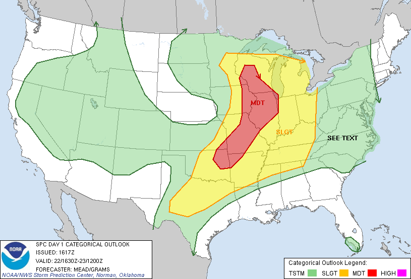

SPC AC 221617
DAY 1 CONVECTIVE OUTLOOK
NWS STORM PREDICTION CENTER NORMAN OK
1117 AM CDT SUN MAY 22 2011
VALID 221630Z - 231200Z
...THERE IS A MDT RISK OF SVR TSTMS OVER SERN MN...ERN IA...PARTS OF
WI/IL/MO...NERN OK AND NWRN AR...
...THERE IS A SLGT RISK OF SVR TSTMS FROM THE GREAT LAKES INTO THE
SRN PLAINS...
...UPPER GREAT LAKES INTO THE MID MS AND OH VALLEYS...
DEEP-LAYER CYCLONE OVER ERN SD WILL TRANSLATE EWD INTO THE UPPER MS
VALLEY BY THIS EVENING WITH AN ASSOCIATED 50-60 KT MIDLEVEL JET
STREAK OVERSPREADING THE UPPER MIDWEST THROUGH THE PEAK OF THE
DIURNAL HEATING CYCLE. SURFACE CYCLONE WILL ACCORDINGLY DEVELOP EWD
TO CNTRL MN BY 23/00Z WITH ASSOCIATED WARM FRONT RAPIDLY LIFTING NWD
THROUGH ERN IA/IL INTO WI AND LOWER MI TODAY. HEIGHT FALLS/DYNAMIC
FORCING FOR ASCENT ATTENDANT TO MIDLEVEL SYSTEM COUPLED WITH FRONTAL
UPLIFT WILL FOSTER SCATTERED SVR TSTMS BY EARLY AFTERNOON INITIALLY
FROM PORTIONS OF E-CNTRL/SERN MN AND ERN IA/NERN MO INTO WI/IL.
THE COMBINATION OF A MOIST...MODERATELY TO STRONGLY UNSTABLE AIR
MASS --I.E. MLCAPE RANGING FROM 1000-1500 J/KG OVER MN/WI TO
2000-3000 J/KG ACROSS MO/IL-- COUPLED WITH 40-50 KT DEEP-LAYER SHEAR
ORIENTED ORTHOGONAL TO SURFACE FRONT WILL YIELD A BAND OF SUPERCELLS
CAPABLE OF TORNADOES...LARGE HAIL AND DAMAGING WINDS. THE GREATEST
TORNADO POTENTIAL --SOME POTENTIALLY SIGNIFICANT-- APPEARS TO BE
ACROSS CNTRL/SRN WI INTO IL THIS AFTERNOON AND EVENING WHERE
LOW-LEVEL SHEAR WILL BE ENHANCED BY A GRADUALLY STRENGTHENING LLJ.
STORMS MAY GROW UPSCALE INTO A QLCS TONIGHT WITH A CONTINUED THREAT
FOR MAINLY HAIL AND DAMAGING WIND GUSTS SPREADING EWD THROUGH LOWER
MI AND THE OH VALLEY.
FOR ADDITIONAL NEAR TERM GUIDANCE...SEE MCD 849.
...SRN PLAINS...
12Z REGIONAL SOUNDINGS SHOWED THE POTENTIAL FOR EXPLOSIVE TSTM
DEVELOPMENT LATER TODAY WITH A VERY MOIST BOUNDARY LAYER BENEATH
STEEP MIDLEVEL LAPSE RATES...RESULTING IN MLCAPE OF 3000-4000 J/KG.
GIVEN THAT LARGE-SCALE FORCING FOR ASCENT WILL REMAIN NEGLIGIBLE
THROUGH THE DIURNAL HEATING CYCLE...THE PRIMARY UNCERTAINTIES ARE
LOCATION AND EVENTUAL COVERAGE OF SEVERE STORMS.
DRYLINE LOCATED FROM WRN OK INTO W-CNTRL AND SWRN TX AS OF MID
MORNING WILL MIX MOST RAPIDLY EWD TODAY ACROSS NRN HALF OF OK WITH
THE BOUNDARY EXTENDING FROM E OF THE I-44 CORRIDOR INTO W-CNTRL TX
BY MID/LATE AFTERNOON. CURRENTLY THE HIGHEST PROBABILITY FOR
DIURNAL TSTM DEVELOPMENT APPEARS TO BE FROM NERN OK NEWD INTO MO
WHERE AREA WILL BE INFLUENCED BY LEFT EXIT REGION OF UPPER JET
STREAK STRETCHING FROM THE SRN ROCKIES INTO SRN PLAINS.
HOWEVER...GIVEN THE POTENTIAL FOR STRONG HEATING W OF DRYLINE AND A
BREAKABLE CAP /SEE 12Z FWD SOUNDING/...ISOLATED SEVERE STORMS WILL
BE POSSIBLE ALONG THE LENGTH OF THE DRYLINE.
LATEST MODEL GUIDANCE SUGGESTS DEEPER PBL MIXING MAY LEAD TO
DECREASING LOW-LEVEL MOISTURE CONTENT THIS AFTERNOON...LARGELY
ACROSS PORTIONS OF CNTRL/ERN TX. WHILE THIS MAY TEMPER THE DEGREE
OF INSTABILITY...EXPECT AFTERNOON MLCAPE VALUES OF 3000-4000+ J/KG.
WHEN COUPLED WITH 35-40 KT OF DEEP WLY SHEAR...SETUP WILL FAVOR THE
DEVELOPMENT OF SUPERCELLS WITH VERY LARGE HAIL BEING THE PRIMARY
HAZARD. THE TORNADO THREAT WILL INCREASE IN THE 23/00-03Z TIME
PERIOD AS A STRENGTHENING SLY LLJ ENHANCES LOW-LEVEL SHEAR.
...LOWER MS/TN VALLEYS INTO SRN APPALACHIANS...
REGENERATIVE TSTM DEVELOPMENT IS OCCURRING THIS MORNING ACROSS AR
WITHIN A ZONE OF LOW-LEVEL WAA ASSOCIATED WITH A SWLY LLJ
ORIGINATING OVER SRN TX. CONTINUED HEATING/DESTABILIZATION ALONG
THE SRN/ERN PERIPHERY OF ONGOING STORMS IN CONCERT WITH A
GROWING/DEEPENING COLD POOL MAY ALLOW FOR THE DEVELOPMENT OF A
FORWARD-PROPAGATING MCS WITH EMBEDDED SUPERCELLS WHICH WOULD TRACK
ACROSS THE TN VALLEY AND NRN GULF COAST STATES WITH ATTENDANT
THREATS OF DAMAGING WINDS AND HAIL AND PERHAPS A COUPLE TORNADOES.
FOR ADDITIONAL NEAR-TERM GUIDANCE...SEE MCD 850.
...LOWER GREAT LAKES INTO NC...
THE EWD PROGRESSION OF A COUPLE OF WEAK MIDLEVEL IMPULSES WILL
PROVIDE SUFFICIENT BACKGROUND FORCING TO SUPPORT DIURNAL TSTM
DEVELOPMENT WITHIN A WARMING/DESTABILIZING AIR MASS WHERE AFTERNOON
MLCAPE WILL RANGE FROM 1000-2000 J/KG OVER NC TO AROUND 500 J/KG
ACROSS PORTIONS OF NY/PA. THE STRONGEST VERTICAL SHEAR WILL RESIDE
ACROSS THE LOWER GREAT LAKES...DIMINISHING WITH SWD EXTENT. AS
SUCH...THE POTENTIAL WILL EXIST FOR A FEW STRONG-MARGINALLY SEVERE
STORMS THIS AFTERNOON INTO EVENING WITH THE PRIMARY THREATS BEING
HAIL AND LOCALLY STRONG WIND GUSTS.
..MEAD/GRAMS.. 05/22/2011
CLICK TO GET WUUS01 PTSDY1 PRODUCT
NOTE: THE NEXT DAY 1 OUTLOOK IS SCHEDULED BY 2000Z
0 likes
-
CrazyC83
- Professional-Met
- Posts: 34315
- Joined: Tue Mar 07, 2006 11:57 pm
- Location: Deep South, for the first time!
viewtopic.php?f=24&t=111941
Old thread on the service assessment released in September. It clearly mentions that WFO Springfield was basically helpless as well, since there was no way they could have brought out the extreme warnings in time given the information available. Radar scans were separated by 9 minutes - in that time, it went from a mere rotating supercell with a weak tornado possibly reported doing EF0-EF1 damage at 5:34 pm (which no one should be injured in if they are taking proper action) to an EF5 monster flattening everything at 5:43 pm (which is unsurvivable in many cases). There is no way a Tornado Emergency could be brought out for a rotating supercell with no ground truth (5:34 pm). They definitely could have put a Tornado Emergency out at the update at 5:48 pm based on a combination of radar and ground truth, but by then it had already done half of the extreme damage. If ground truth had QUICKLY made it to the office (radar not yet available), the 5:42 pm Severe Weather Statement COULD have had that wording, which still would have been too late for parts of Joplin.
The people of Joplin could not really be blamed for not taking the warning - there was no indication at the critical time that this would be an extreme monster. By the time the threat was clear, it was already in town doing catastrophic damage.
0 likes
-
Texas Snowman

- Storm2k Moderator

- Posts: 6197
- Joined: Fri Jan 25, 2008 11:29 am
- Location: Denison, Texas
It was a wicked, wicked tornado for sure. Most chilling storm of my lifetime.
Sometimes there is a delay in the flow of information after a tornado strike. Not this one.
I was hearing on Twitter of "catastrophic destruction" w/in minutes of the hit. Then there was The Weather Channel chase crew that arrived on the scene so quickly and reported the catstrophe with choked up voices and tears in their eyes.
I remember that the first tweets I read sent a literal shiver down my spine and I told my sons, "Something really bad has happened in Joplin."
0 likes
The above post and any post by Texas Snowman is NOT an official forecast and should not be used as such. It is just the opinion of the poster and may or may not be backed by sound meteorological data. It is NOT endorsed by any professional institution including storm2k.org. For official information, please refer to NWS products.
-
Texas Snowman
- Storm2k Moderator
- Posts: 6197
- Joined: Fri Jan 25, 2008 11:29 am
- Location: Denison, Texas
I know that the emergency management people, NWS, etc. have all tried to assess and learn what could have been done better in an effort to save more lives in Joplin.
But as mentioned, there wasn't much more they could have done.
I think at the end of the day, all of us as citizens in tornado prone areas must simply understand that no matter how many times there is a false alarm or a weak tornado that hops through the countryside, we must all take each and every single warning as a potential catastrophe.
0 likes
The above post and any post by Texas Snowman is NOT an official forecast and should not be used as such. It is just the opinion of the poster and may or may not be backed by sound meteorological data. It is NOT endorsed by any professional institution including storm2k.org. For official information, please refer to NWS products.
-
Texas Snowman
- Storm2k Moderator
- Posts: 6197
- Joined: Fri Jan 25, 2008 11:29 am
- Location: Denison, Texas
In addition to the Joplin tornado last year, the Jarrell, Texas tornado in 1997 comes to mind as an example of why every warning must be taken so seriously.
It was initially a weak, rope-like tornado that rapidly intensified into a 3/4 mile multi-vortex F5.
But like Joplin, the tornado there maxed out so quickly and was so violent that the residents in that subdivision where most of the 27 were killed simply had little chance.
It was initially a weak, rope-like tornado that rapidly intensified into a 3/4 mile multi-vortex F5.
But like Joplin, the tornado there maxed out so quickly and was so violent that the residents in that subdivision where most of the 27 were killed simply had little chance.
0 likes
The above post and any post by Texas Snowman is NOT an official forecast and should not be used as such. It is just the opinion of the poster and may or may not be backed by sound meteorological data. It is NOT endorsed by any professional institution including storm2k.org. For official information, please refer to NWS products.
-
brunota2003

- S2K Supporter

- Posts: 9476
- Age: 35
- Joined: Sat Jul 30, 2005 9:56 pm
- Location: Stanton, KY...formerly Havelock, NC
- Contact:
I do have to ask...why do we not have a radar that scans two sectors simultaneously? The bottom one can focus on the 0.5 through 3.4 degree scans, the top can focus on the upper scans...then you have a picture that is updating twice as quick as now, because instead of waiting for one antenna to scan all the layers, you have two scanning the same amount of layers.
0 likes
Just a small town southern boy helping other humans.
-
CrazyC83
- Professional-Met
- Posts: 34315
- Joined: Tue Mar 07, 2006 11:57 pm
- Location: Deep South, for the first time!
Re:
brunota2003 wrote:I do have to ask...why do we not have a radar that scans two sectors simultaneously? The bottom one can focus on the 0.5 through 3.4 degree scans, the top can focus on the upper scans...then you have a picture that is updating twice as quick as now, because instead of waiting for one antenna to scan all the layers, you have two scanning the same amount of layers.
The upper scans don't mean too much in a tornado scenario, so yeah I agree. There was no dual-pol at the time. Hopefully they come up with a high-speed radar eventually as well.
0 likes

Never Forget
One of the most crazy weather events I've ever lived during. Just this one tornado can be more interesting and catastrophic than an entire YEAR of tornadoes combined, that is astonishing. Made history in countless ways and displayed the most intense chaos. Its this that propels people into weather and meteorology.
High-speed radars already exist, one scan every minute but for some dumb reason, its not being made to the public yet. Hopefully it comes through NOAAPORT sooner rather than later because it would really rocket radar advancement among everyone. I also see DOW scanning pretty fast when its out there but I don't know the rate.
CrazyC83 wrote:Hopefully they come up with a high-speed radar eventually as well.
High-speed radars already exist, one scan every minute but for some dumb reason, its not being made to the public yet. Hopefully it comes through NOAAPORT sooner rather than later because it would really rocket radar advancement among everyone. I also see DOW scanning pretty fast when its out there but I don't know the rate.
0 likes
-
HurricaneBill
- Category 5
- Posts: 3419
- Joined: Sun Apr 11, 2004 5:51 pm
- Location: East Longmeadow, MA, USA
Re: One year ago today - Joplin
Only two of the fatalities were in mobile homes. The main reason for this was because Joplin had an ordinance prohibiting trailer parks. We probably would have seen a higher death toll had there been trailer parks in the tornado's path.
0 likes
-
CrazyC83
- Professional-Met
- Posts: 34315
- Joined: Tue Mar 07, 2006 11:57 pm
- Location: Deep South, for the first time!
Re: One year ago today - Joplin
HurricaneBill wrote:Only two of the fatalities were in mobile homes. The main reason for this was because Joplin had an ordinance prohibiting trailer parks. We probably would have seen a higher death toll had there been trailer parks in the tornado's path.
Also very few of the fatalities were in vehicles as well. It seems people tried to take shelter but it was not sufficient. Most of the fatalities were in permanent homes or public buildings.
0 likes
-
HurricaneBill
- Category 5
- Posts: 3419
- Joined: Sun Apr 11, 2004 5:51 pm
- Location: East Longmeadow, MA, USA
Re:
RL3AO wrote:The past two episodes of weatherbrains have discussed Joplin.
A week ago was the EM from Joplin claiming they did the best they could.
This week was author Mike Smith claiming that the EM and WFO Springfield made large mistakes that likely cost people their lives.
I think the EM did the best they could. This was an extremely intense tornado.
0 likes
The author's big complaint wait that when the first warning was issued it did not include Joplin and that the EM decided to set the sirens off for the entire county even though they had the option to set it off for zones. Four minutes later a new warning was issued that including Joplin and the EM decided not to re-sound the sirens. His argument was that people in Joplin would have tuned into radio and tv and heard that Joplin was not included in the warning and therefore the sirens should have been re-sounded after the warning was issued to include Joplin.
TBH, its probably a little bit in the middle. He needed to find the material for his new book (his first was good BTW, How Science has Tamed the Weather...written in 2010).
TBH, its probably a little bit in the middle. He needed to find the material for his new book (his first was good BTW, How Science has Tamed the Weather...written in 2010).
0 likes
Return to “USA & Caribbean Weather”
Who is online
Users browsing this forum: AnnularCane, Stratton23, txtwister78 and 98 guests