
Aric Dunn wrote:12z GFS is rather interesting..
Looks like 12z GFS also prompted JB to tweet:
“@BigJoeBastardi: Letting people know in se Fla, Bahamas they should keep an eye on this system as it is now "next week" and id'd or not, will be player”
Moderator: S2k Moderators

Aric Dunn wrote:12z GFS is rather interesting..


Aric Dunn wrote:SouthDadeFish wrote:The shear axis does shift, but there won't be a low there in the first place with that kind of wind shear.... at least in my opinion.
it looks lightly not tropical at first. so the surface low would be able to deepen.

SouthDadeFish wrote:Aric Dunn wrote:SouthDadeFish wrote:The shear axis does shift, but there won't be a low there in the first place with that kind of wind shear.... at least in my opinion.
it looks lightly not tropical at first. so the surface low would be able to deepen.
It does appear to be a subtropical set-up, but this is suspicious to me since the GFS is feeding off of the 850mb vorticity that came from the Caribbean, which is not a subtropical set up.

SouthDadeFish wrote:Aric my suspicion is that we may very well see development in the NW Caribbean if the disturbance can remain in this area of another 36 hours or so. Check out how the 12Z GFS relaxes the 200mb winds in the NW Caribbean in only 36 hours:
[img]http://img12.imageshack.us/img12/2393/gfsatlantic036200wndht.gif[/mg]
200mb winds throughout the NW Caribbean are less than 20 knots. What do you think?


The posts in this forum are NOT official forecast and should not be used as such. They are just the opinion of the poster and may or may not be backed by sound meteorological data. They are NOT endorsed by any professional institution or storm2k.org. For official information, please refer to the NHC and NWS products


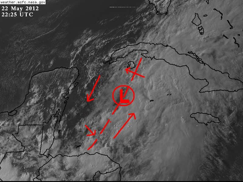
northjaxpro wrote:Observing the visible satellite imagery, it appears to me that a circulation center may be trying to organize a bit farther north just to the southwest of the Isle of Youth.
[img]http://www.ssd.noaa.gov/goes/east/carb/vis-l.jpg[img]
Aric Dunn wrote:northjaxpro wrote:Observing the visible satellite imagery, it appears to me that a circulation center may be trying to organize a bit farther north just to the southwest of the Isle of Youth.
[img]http://www.ssd.noaa.gov/goes/east/carb/vis-l.jpg[img]
well just from a rotational dynamics point of view it would favor the south vort but not till it swings farther east when it meets the strong southerly flow off the Honduras coast and just like yesterday the northern low will lose the dynamics as it rotates SW later. this process keeps happening because convection will not maintain over any of the vorts because the northern half is to highly sheared. but now that the southern half has much lower shear so tonight it may take over if convection build around it.


FRI-SUN (PREVIOUS DISCUSSION)...INVERTED SFC TROUGH IS FORECAST
TO LIFT NORTHWARD FROM CUBA ACROSS S FL AND THE NORTHERN BAHAMAS
INCREASING THE ONSHORE FLOW AND CYCLONIC CONVERGENCE. THIS SHOULD
KEEP AT LEAST A SLIGHT (20 PERCENT) CHANCE FOR SHOWERS WITH
SLIGHTLY HIGHER POPS TO THE SOUTH. THEN SFC TROUGH IS FORECAST TO
BREAKDOWN AND SHIFT WESTWARD ACROSS THE FL PENINSULA THIS WEEKEND
AS DEEP LAYER HIGH PRESSURE DEVELOPS OVER THE SOUTHEAST U.S. THIS
SHOULD INCREASE THE ONSHORE FLOW SAT AND SUN WITH AN OVERALL
INCREASE IN MOISTURE ACROSS THE FA. HAVE DRAWN MOSTLY 30 POPS BOTH
DAYS THOUGH SUNDAY STILL LOOKS LIKE THE BETTER CHANCE FOR SHOWERS
AS THE REMNANT INVERTED TROUGH SHIFTS WEST OF THE AREA. IT WILL BE
AT LEAST PARTLY CLOUDY WITH PERIODS OF OVERCAST POSSIBLE AND
BREEZY ESP AT THE COAST.
Users browsing this forum: No registered users and 156 guests

