
ATL: BERYL - Post-Tropical
Moderator: S2k Moderators
-
cycloneye

- Admin

- Posts: 149275
- Age: 69
- Joined: Thu Oct 10, 2002 10:54 am
- Location: San Juan, Puerto Rico
Re: ATL: INVEST 94L
The 00z surface analysis.
0 likes
Visit the Caribbean-Central America Weather Thread where you can find at first post web cams,radars
and observations from Caribbean basin members Click Here
and observations from Caribbean basin members Click Here
-
AdamFirst

- S2K Supporter

- Posts: 2490
- Age: 36
- Joined: Thu Aug 14, 2008 10:54 am
- Location: Port Saint Lucie, FL
Re: ATL: INVEST 94L
Miami International Airport's daily rainfall record was obliterated today - 9.7 inches recorded
(I'm pretty sure other locales in the west-central Metro, such as Hialeah, Doral and Sweetwater also reached records today)
If this system dampens out and manages to drop even more rain, it could turn into a devastating flood event for South Florida
(I'm pretty sure other locales in the west-central Metro, such as Hialeah, Doral and Sweetwater also reached records today)
If this system dampens out and manages to drop even more rain, it could turn into a devastating flood event for South Florida
Personal Forecast Disclaimer:
The posts in this forum are NOT official forecast and should not be used as such. They are just the opinion of the poster and may or may not be backed by sound meteorological data. They are NOT endorsed by any professional institution or storm2k.org. For official information, please refer to the NHC and NWS products.
Last edited by AdamFirst on Tue May 22, 2012 10:56 pm, edited 1 time in total.
0 likes
Dolphins Marlins Canes Golden Panthers HEAT
Andrew 1992 - Irene 1999 - Frances 2004 - Jeanne 2004 - Wilma 2005 - Fay 2008 - Isaac 2012 - Matthew 2016 - Irma 2017 - Dorian 2019 - Ian 2022 - Nicole 2022 - Milton 2024
Andrew 1992 - Irene 1999 - Frances 2004 - Jeanne 2004 - Wilma 2005 - Fay 2008 - Isaac 2012 - Matthew 2016 - Irma 2017 - Dorian 2019 - Ian 2022 - Nicole 2022 - Milton 2024
-
floridasun78
- Category 5

- Posts: 3755
- Joined: Sun May 17, 2009 10:16 pm
- Location: miami fl
-
vbhoutex

- Storm2k Executive
- Posts: 29145
- Age: 74
- Joined: Wed Oct 09, 2002 11:31 pm
- Location: Cypress, TX
- Contact:
Re: Re:
TropicalAnalystwx13 wrote:@vbhourtex: While it may be elongated and weak, a low-level circulation definitely exists in the northwest Caribbean Sea just south of the Isle of Youth. This is depicted by 850/925 mbar vorticity maps and could be viewed using visible/RGB satellite loops when they were available.
http://tropic.ssec.wisc.edu/real-time/a ... wg8vor.GIF
All that map shows is the vorticity in the area. It does not show a low. The quote you bolded and disagreed with said that there wasn't a 25kt LLC. There still isn't from what I have seen so far. A LLC is just that, a somewhat concentrated area of circulation, not an elongated area of lower pressure. Do you have any proof of the 25kt winds? I have looked at several different satellite loops and I see no indication of a LLC S of the Isle of Youth. Yes there is an elongated area of low pressure attached to a trough, but what I consider(and have learned to be a LLC)does not exist. I have to agree with wxman57 on this one.
0 likes
Skywarn, C.E.R.T.
Please click below to donate to STORM2K to help with the expenses of keeping the site going:

Please click below to donate to STORM2K to help with the expenses of keeping the site going:
-
JonathanBelles
- Professional-Met

- Posts: 11430
- Age: 35
- Joined: Sat Dec 24, 2005 9:00 pm
- Location: School: Florida State University (Tallahassee, FL) Home: St. Petersburg, Florida
- Contact:


Re: Re:
Look about 100 miles or so SW of the Isle of Youth,you can see a rotation maybe not at the low levels but at the mid level.
http://www.ssd.noaa.gov/goes/east/watl/flash-vis.html
http://www.ssd.noaa.gov/goes/east/watl/flash-vis.html
0 likes
-
SouthDadeFish

- Professional-Met
- Posts: 2835
- Joined: Thu Sep 23, 2010 2:54 pm
- Location: Miami, FL
- Contact:
What I find interesting is that 500mb vorticity has been advecting over Central America today and has now emerged over the Caribbean:

Vorticity at the lower levels is still elongated N-S. Looking at satellite there are two main areas of convection: one on the north side, and one on the south side:

With the aid of more 500mb vorticity, I'm curious if the southern blob may work down its own LLC. This southern area of convection is in fact the remnants of the naked swirl we have been seeing spin around the NW Caribbean over the past several days. I could see how the northern side of convection gets sheared off overnight, while this southern area in more favorable conditions becomes more dominant. Or this could just stay a sheared mess and never develop
Vorticity at the lower levels is still elongated N-S. Looking at satellite there are two main areas of convection: one on the north side, and one on the south side:
With the aid of more 500mb vorticity, I'm curious if the southern blob may work down its own LLC. This southern area of convection is in fact the remnants of the naked swirl we have been seeing spin around the NW Caribbean over the past several days. I could see how the northern side of convection gets sheared off overnight, while this southern area in more favorable conditions becomes more dominant. Or this could just stay a sheared mess and never develop
0 likes

Re:
CrazyC83 wrote:Another Invest??? Is it really May 22?
I knew this period was going to be active, but not by this much. Both the Atlantic and Epac are pretty active for mid to late May after the major drought of worldwide TC activity (a record 41 days without a single active TC occurred last month until it was broken by Aletta) so now "Equilibrium" starts. I bet most people didn't think this level of activity in the Atlantic would start until August. Let me just say, if your expecting another 2006 or 2009 (Nino or not), your going to be in for a surprise.
vbhoutex wrote:I honestly have not looked at anything concerning this today, but I doubt that a professional meteorologist would make a statement such as that unless he has information to back it up. Do you have information to back it up? If you do please post it.
25 Knots comes from the NRL and the file, LLC is not there. They put 25 knots there even if it doesn't have that high of winds yet and this is where the misunderstanding is.
Miami International Airport's daily rainfall record was obliterated today - 9.7 inches recorded
I didn't know south Florida was experiencing flood problems like this, quite something. This could be another case where certain parts of the US get total drought (which I believe will happen up north) and parts of the south get floods and nothing normalizes. It reversed from last year but the extremes are possibly yet to come.
0 likes

Re: ATL: INVEST 94L
All I see is a trof of low pressure with minimal convection right now. No LLC here....have to go with VB on this one....
0 likes
-
JonathanBelles
- Professional-Met
- Posts: 11430
- Age: 35
- Joined: Sat Dec 24, 2005 9:00 pm
- Location: School: Florida State University (Tallahassee, FL) Home: St. Petersburg, Florida
- Contact:
Re: ATL: INVEST 94L
ROCK wrote:All I see is a trof of low pressure with minimal convection right now. No LLC here....have to go with VB on this one....
Yea, i've been struggling all night to see anything.
0 likes

Re: ATL: INVEST 94L
AdamFirst wrote:Miami International Airport's daily rainfall record was obliterated today - 9.7 inches recorded
(I'm pretty sure other locales in the west-central Metro, such as Hialeah, Doral and Sweetwater also reached records today)
If this system dampens out and manages to drop even more rain, it could turn into a devastating flood event for South FloridaPersonal Forecast Disclaimer:
The posts in this forum are NOT official forecast and should not be used as such. They are just the opinion of the poster and may or may not be backed by sound meteorological data. They are NOT endorsed by any professional institution or storm2k.org. For official information, please refer to the NHC and NWS products.
Late Spring/Early Summer is the favorable time for Southeast Florida to get a lot of rain.
Fronts and troughs get near here and force upper level Southwest and Westerly wind flow while the NW Carib. starts getting juicy so moisture increases, PWAT's are high and we get clobbered with afternoon thunderstorms that can dump inches of rain in isolated areas. Then as June/July come around we get the easterly flow and the storms stay inland and/or affect the Gulf coast.
While 9.7 inches is excessive; enjoy the welcome rain to fill back up the lakes and water table after the drought season and before we start baking in the afternoons and the storms move away from the Southeast Peninsula.
As for 94L and its potential to add even more rain; our soil is pretty resilient so it takes a whole lot to turn into a devastating flood event down here. Oh, a stalled tropical system that dumps 20-30 inches will wreak havoc, but it takes something incredibly rare for that to happen. Luckily, our soil can absorb tremendous amounts of water and anything more than localized street flooding is highly unusual.
0 likes
-
cycloneye
- Admin
- Posts: 149275
- Age: 69
- Joined: Thu Oct 10, 2002 10:54 am
- Location: San Juan, Puerto Rico
Re: ATL: INVEST 94L
This discussion of 94L is by our friend Rob of Crown Weather Services.
The following post is NOT an official forecast and should not be used as such. It is just the opinion of the poster and may or may not be backed by sound meteorological data. It is NOT endorsed by any professional institution including storm2k.org. For Official Information please refer to the NHC and NWS products.
http://www.crownweather.com/?page_id=4557
Invest 94-L In The Northwestern Caribbean Likely Not To Develop Today Through Thursday; Sub-Tropical Or Tropical Development Possible Near The South Carolina Coast This Weekend
Wednesday, May 23, 2012 5:44 am
by Rob Lightbown
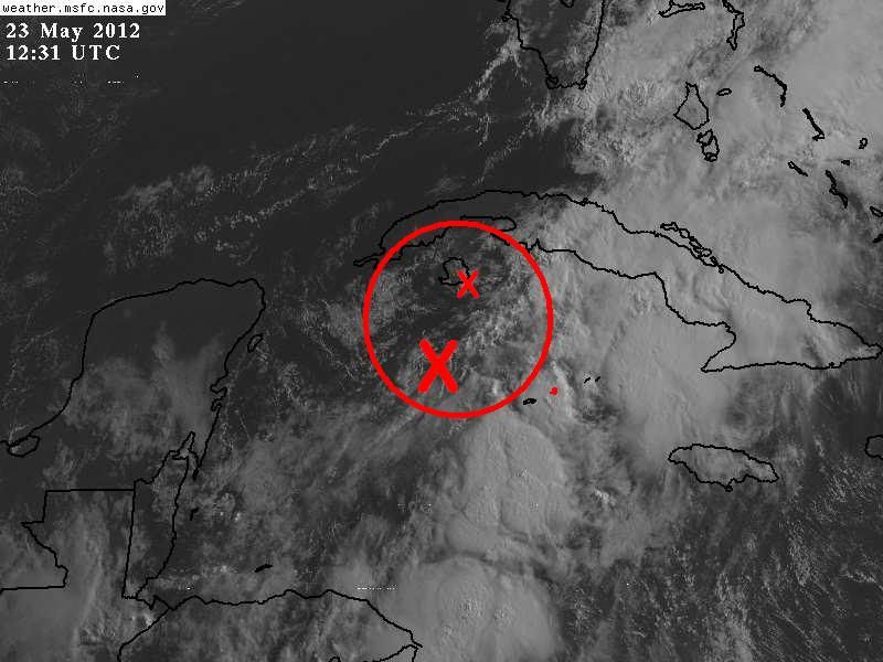
Low pressure located about 125 miles southwest of the Cayman Islands has been designated Invest 94-L by the National Hurricane Center. Analysis of 850 millibar and 700 millibar vorticity values (the amount of spin in the atmosphere) reveals an elongated area of vorticity stretching from the Florida Straits southwestward across much of the western Caribbean. Shear values across the western Caribbean this morning range from 20 knots near the northern coast of Honduras to 40 to 60 knots near the southern coast of Cuba.
As it stands right now, Invest 94-L is in an area that is not favorable for development. Much of the convection is located to the east of the low pressure system, wind shear values are quite hostile and it is still attached to a trough of low pressure and has not isolated itself.
The short range NAM model forecasts that this low pressure system will lift out of the Caribbean and into the Gulf of Mexico during Thursday and redevelop along the South Carolina coast by later Friday. A bout of heavy rainfall, associated with this low pressure system is first expected across the Florida Keys starting this afternoon and spreading northward into south Florida during Thursday. This heavy rainfall is expected to continue across south Florida and the Florida Keys into Thursday evening before ending later Thursday night.
The GFS model guidance does nothing with Invest 94L, however, it does forecast that a tropical cyclone will develop in the western Caribbean by about the middle part of next week before it lifts northeastward across south Florida late next Thursday and along the US East Coast next Friday and next Saturday.
The European model forecasts that an area of low pressure will develop about 300 miles east of Savannah, Georgia on Friday night and Saturday and forecasts this low pressure system to track west-southwestward towards the coast of northeast Florida by Sunday and Memorial Day.
The NOGAPS model looks very similar to the NAM model as it forecasts that Invest 94-L will weaken as it tracks into the Gulf of Mexico on Thursday and redevelop along the coast of South Carolina on Friday. From there the NOGAPS model forecasts that this low pressure system will track southwestward along the coast of South Carolina during Saturday before tracking onto the Georgia coast on Sunday.
At this point, I think development of Invest 94-L is unlikely today through Thursday due to very strong wind shear values. Now, should an area of low pressure develop along the US Southeast coast this weekend, some sort of sub-tropical or tropical development is possible as environmental conditions will be somewhat favorable for development and this is something that will need to be monitored closely.
Additionally, the GFS model’s forecast of a tropical cyclone developing in the western Caribbean around the middle part of next week may have some merit as the overall pattern favors lowering pressures over the far western Caribbean by next week. This will be something that we will keep a close eye on.
The following post is NOT an official forecast and should not be used as such. It is just the opinion of the poster and may or may not be backed by sound meteorological data. It is NOT endorsed by any professional institution including storm2k.org. For Official Information please refer to the NHC and NWS products.
http://www.crownweather.com/?page_id=4557
Invest 94-L In The Northwestern Caribbean Likely Not To Develop Today Through Thursday; Sub-Tropical Or Tropical Development Possible Near The South Carolina Coast This Weekend
Wednesday, May 23, 2012 5:44 am
by Rob Lightbown
Low pressure located about 125 miles southwest of the Cayman Islands has been designated Invest 94-L by the National Hurricane Center. Analysis of 850 millibar and 700 millibar vorticity values (the amount of spin in the atmosphere) reveals an elongated area of vorticity stretching from the Florida Straits southwestward across much of the western Caribbean. Shear values across the western Caribbean this morning range from 20 knots near the northern coast of Honduras to 40 to 60 knots near the southern coast of Cuba.
As it stands right now, Invest 94-L is in an area that is not favorable for development. Much of the convection is located to the east of the low pressure system, wind shear values are quite hostile and it is still attached to a trough of low pressure and has not isolated itself.
The short range NAM model forecasts that this low pressure system will lift out of the Caribbean and into the Gulf of Mexico during Thursday and redevelop along the South Carolina coast by later Friday. A bout of heavy rainfall, associated with this low pressure system is first expected across the Florida Keys starting this afternoon and spreading northward into south Florida during Thursday. This heavy rainfall is expected to continue across south Florida and the Florida Keys into Thursday evening before ending later Thursday night.
The GFS model guidance does nothing with Invest 94L, however, it does forecast that a tropical cyclone will develop in the western Caribbean by about the middle part of next week before it lifts northeastward across south Florida late next Thursday and along the US East Coast next Friday and next Saturday.
The European model forecasts that an area of low pressure will develop about 300 miles east of Savannah, Georgia on Friday night and Saturday and forecasts this low pressure system to track west-southwestward towards the coast of northeast Florida by Sunday and Memorial Day.
The NOGAPS model looks very similar to the NAM model as it forecasts that Invest 94-L will weaken as it tracks into the Gulf of Mexico on Thursday and redevelop along the coast of South Carolina on Friday. From there the NOGAPS model forecasts that this low pressure system will track southwestward along the coast of South Carolina during Saturday before tracking onto the Georgia coast on Sunday.
At this point, I think development of Invest 94-L is unlikely today through Thursday due to very strong wind shear values. Now, should an area of low pressure develop along the US Southeast coast this weekend, some sort of sub-tropical or tropical development is possible as environmental conditions will be somewhat favorable for development and this is something that will need to be monitored closely.
Additionally, the GFS model’s forecast of a tropical cyclone developing in the western Caribbean around the middle part of next week may have some merit as the overall pattern favors lowering pressures over the far western Caribbean by next week. This will be something that we will keep a close eye on.
0 likes
Visit the Caribbean-Central America Weather Thread where you can find at first post web cams,radars
and observations from Caribbean basin members Click Here
and observations from Caribbean basin members Click Here

Re: ATL: INVEST 94L
I am watching the area around 15N or south where UL outflow looks favorable and shear low.
Seen many times where weak LLCs quickly reform to new areas in the west Carib.
Not saying its going to happen, just watching.
Persistent convection is key, especially if a hot-tower fires up.
Seen many times where weak LLCs quickly reform to new areas in the west Carib.
Not saying its going to happen, just watching.
Persistent convection is key, especially if a hot-tower fires up.
0 likes
-
adam0983
Re: ATL: INVEST 94L
Does anyone think that Invest 94L can develop into a tropical depression?
0 likes
-
tolakram
- Admin
- Posts: 20179
- Age: 62
- Joined: Sun Aug 27, 2006 8:23 pm
- Location: Florence, KY (name is Mark)
Re: ATL: INVEST 94L

0 likes
M a r k
- - - - -
Join us in chat: Storm2K Chatroom Invite. Android and IOS apps also available.
The posts in this forum are NOT official forecasts and should not be used as such. Posts are NOT endorsed by any professional institution or STORM2K.org. For official information and forecasts, please refer to NHC and NWS products.

Re: ATL: INVEST 94L
I like the area to south better off the Nic / Hon border - seeing some overshooting tops
http://wwwghcc.msfc.nasa.gov/cgi-bin/post-goes
TPW is high
http://www.osdpd.noaa.gov/bTPW/TPW_Anim ... LANTIC_TPW
Watching to see if MCS's fire over land this afternoon and work their way over water.
http://wwwghcc.msfc.nasa.gov/cgi-bin/post-goes
TPW is high
http://www.osdpd.noaa.gov/bTPW/TPW_Anim ... LANTIC_TPW
Watching to see if MCS's fire over land this afternoon and work their way over water.
0 likes
Re: ATL: INVEST 94L
Looks like a high rain-rate hot tower did fire about 10 hrs ago on the border. Cell has since moved NE out into the water.
http://www.nrlmry.navy.mil/nexsat-bin/n ... Caribbean&
http://www.nrlmry.navy.mil/nexsat-bin/n ... Caribbean&
0 likes
-
floridasun78
- Category 5
- Posts: 3755
- Joined: Sun May 17, 2009 10:16 pm
- Location: miami fl

Re: ATL: INVEST 94L
GCANE wrote:I like the area to south better off the Nic / Hon border - seeing some overshooting tops
http://wwwghcc.msfc.nasa.gov/cgi-bin/post-goes
TPW is high
http://www.osdpd.noaa.gov/bTPW/TPW_Anim ... LANTIC_TPW
Watching to see if MCS's fire over land this afternoon and work their way over water.
I also like this area better but the pressure is lower rather north. If anything is to develop out of this it would seem the area father south would have a much better go at it, lower shear and higher moisture content.


0 likes
The following post is NOT an official forecast and should not be used as such. It is just the opinion of the poster and may or may not be backed by sound meteorological data. It is NOT endorsed by any professional institution including storm2k.org For Official Information please refer to the NHC and NWS products.
Who is online
Users browsing this forum: No registered users and 48 guests