ATL: BERYL - Post-Tropical
Moderator: S2k Moderators
-
cycloneye

- Admin

- Posts: 149275
- Age: 69
- Joined: Thu Oct 10, 2002 10:54 am
- Location: San Juan, Puerto Rico
Re: ATL: INVEST 94L
Will history be made with two named systems before June 1rst? You have to go back to 1887 as the last time it occured.
0 likes
Visit the Caribbean-Central America Weather Thread where you can find at first post web cams,radars
and observations from Caribbean basin members Click Here
and observations from Caribbean basin members Click Here
-
Evil Jeremy

- S2K Supporter

- Posts: 5463
- Age: 32
- Joined: Mon Apr 10, 2006 2:10 pm
- Location: Los Angeles, CA
Re: ATL: INVEST 94L
The lower level convergence has been strengthening today, and it's close (but not as close as the vortex) to the Isle of Youth as well. CIMSS charts had the convergence close to the shore of Honduras earlier today, and it's been strengthening and moving NNE today. Vorticity has also been spiking (and curiously is stretched like taffy from Honduras to the Bahamas. It was weaker but more concentrated earlier today)
I'm not expecting much from 94L. Just some heavy rains for SFL. Not that we need it though, we have been getting drenched for the past couple of weeks. Looks like there's too much shear in the region for the Isle of Youth vortex to gain any traction with the convection.
I'm not expecting much from 94L. Just some heavy rains for SFL. Not that we need it though, we have been getting drenched for the past couple of weeks. Looks like there's too much shear in the region for the Isle of Youth vortex to gain any traction with the convection.
0 likes
Frances 04 / Jeanne 04 / Katrina 05 / Wilma 05 / Fay 08 / Debby 12 / Andrea 13 / Colin 16 / Hermine 16 / Matthew 16 / Irma 17
-
cycloneye
- Admin
- Posts: 149275
- Age: 69
- Joined: Thu Oct 10, 2002 10:54 am
- Location: San Juan, Puerto Rico
Re: ATL: INVEST 94L
No question where the main low is.
0 likes
Visit the Caribbean-Central America Weather Thread where you can find at first post web cams,radars
and observations from Caribbean basin members Click Here
and observations from Caribbean basin members Click Here
-
TropicalAnalystwx13

- Category 5

- Posts: 2109
- Age: 28
- Joined: Tue Jul 19, 2011 8:20 pm
- Location: Wilmington, NC
- Contact:
-
Hurricane Andrew

- S2K Supporter
- Posts: 1891
- Age: 27
- Joined: Sun May 23, 2010 2:53 pm
- Location: KS
-
Aric Dunn
- Category 5
- Posts: 21238
- Age: 43
- Joined: Sun Sep 19, 2004 9:58 pm
- Location: Ready for the Chase.
- Contact:
Re:
Hurricane Andrew wrote:No convection over the low though.
nope and there hope be for at least a couple days. Also it will probably spit out a couple more vorts during that time
0 likes
Note: If I make a post that is brief. Please refer back to previous posts for the analysis or reasoning. I do not re-write/qoute what my initial post said each time.
If there is nothing before... then just ask
Space & Atmospheric Physicist, Embry-Riddle Aeronautical University,
I believe the sky is falling...
If there is nothing before... then just ask
Space & Atmospheric Physicist, Embry-Riddle Aeronautical University,
I believe the sky is falling...
-
northjaxpro

- S2K Supporter
- Posts: 8900
- Joined: Mon Sep 27, 2010 11:21 am
- Location: Jacksonville, FL
Re:
Hurricane Andrew wrote:No convection over the low though.
That's to be expected right now with the vort near the Isle of Youth considering that the region down there is under near 40 knots of shear.
Friday into Saturday is the timeframe I believe to really start to focus on possible development. That is the period when this shear axis should begin the migrate north and conditions north of the Bahamas and off the Florida east coast will gradually become somewhat favorable for 94L to try to make an attempt to spin up, in which the reliable models are showing within the next five days.
0 likes
NEVER, EVER SAY NEVER in the tropics and weather in general, and most importantly, with life itself!!
________________________________________________________________________________________
Fay 2008 Beryl 2012 Debby 2012 Colin 2016 Hermine 2016 Julia 2016 Matthew 2016 Irma 2017 Dorian 2019
________________________________________________________________________________________
Fay 2008 Beryl 2012 Debby 2012 Colin 2016 Hermine 2016 Julia 2016 Matthew 2016 Irma 2017 Dorian 2019
-
Aric Dunn
- Category 5
- Posts: 21238
- Age: 43
- Joined: Sun Sep 19, 2004 9:58 pm
- Location: Ready for the Chase.
- Contact:
Re: Re:
northjaxpro wrote:Hurricane Andrew wrote:No convection over the low though.
That's to be expected right now with the vort near the isle of Youth considering that the region down there is under near 40 knots of shear.
Friday into Saturday is the timeframe I believe to really start to focus on possible development. That is the period when this shear axis should begin the migrate north and conditions north of the Bahamas and off the Florida east coast will gradually become somewhat favorable for 94L to try to make an attempt to spin uplike the reliable models are showing within the next five days.
just looked at the NAM 200mb level for 3 days from now. showing same reasoning as euro as for the placement of the upper low. it has it well east of the system with a slight ridging developing near it. hard to tell the placement will be key.
0 likes
Note: If I make a post that is brief. Please refer back to previous posts for the analysis or reasoning. I do not re-write/qoute what my initial post said each time.
If there is nothing before... then just ask
Space & Atmospheric Physicist, Embry-Riddle Aeronautical University,
I believe the sky is falling...
If there is nothing before... then just ask
Space & Atmospheric Physicist, Embry-Riddle Aeronautical University,
I believe the sky is falling...
-
MGC

- S2K Supporter
- Posts: 5940
- Joined: Sun Mar 23, 2003 9:05 pm
- Location: Pass Christian MS, or what is left.
Re: ATL: INVEST 94L
Nothing to see here folks....move along. Little chance if any of 94L becoming a TC any time soon.......MGC
0 likes
-
AJC3

- Admin
- Posts: 4153
- Age: 62
- Joined: Tue Aug 31, 2004 7:04 pm
- Location: Ballston Spa, New York
- Contact:
As was the case with Alberto, any low pressure development E-NE of FL will be BE/BI (baroclinic/non-tropical) in origin. Hence the "shear" being referred to, is actually associated with large scale forced ascent (i.e upper divergence), which in turn will cause lowering of surface pressures. Diagnose exactly where that strongest forced ascent will be, and you'll find where the low will form and eventually try to consolidate. The model solutions lie roughly between 28-35N and 71-75W, give or take, by sometime Friday. Later on in the event (early SAT onward), is when the question becomes when and if this low can transition into a true TC, and just how far and fast it will get forced SW-W.
0 likes

Re: ATL: INVEST 94L
The following post is NOT an official forecast and should not be used as such. It is just the opinion of the poster and may or may not be backed by sound meteorological data. It is NOT endorsed by any professional institution including storm2k.org. For Official Information please refer to the NHC and NWS products.
http://www.youtube.com/watch?v=hdl36Vm-q6s
cycloneye adds S2K disclaimer
http://www.youtube.com/watch?v=hdl36Vm-q6s
cycloneye adds S2K disclaimer
0 likes
-
wxman57

- Moderator-Pro Met

- Posts: 23172
- Age: 68
- Joined: Sat Jun 21, 2003 8:06 pm
- Location: Houston, TX (southwest)
Re: ATL: INVEST 94L
A wave axis is passing the disturbance now. Drying aloft to follow. See the MIMIC TPW page.
0 likes

-
JonathanBelles
- Professional-Met

- Posts: 11430
- Age: 35
- Joined: Sat Dec 24, 2005 9:00 pm
- Location: School: Florida State University (Tallahassee, FL) Home: St. Petersburg, Florida
- Contact:

-
cycloneye
- Admin
- Posts: 149275
- Age: 69
- Joined: Thu Oct 10, 2002 10:54 am
- Location: San Juan, Puerto Rico
Re: ATL: INVEST 94L
00z Best Track
Wind is up and pressure is down.
AL, 94, 2012052400, , BEST, 0, 210N, 826W, 30, 1007, LO
http://ftp.nhc.noaa.gov/atcf/tcweb/inve ... 012.invest
Wind is up and pressure is down.
AL, 94, 2012052400, , BEST, 0, 210N, 826W, 30, 1007, LO
http://ftp.nhc.noaa.gov/atcf/tcweb/inve ... 012.invest
0 likes
Visit the Caribbean-Central America Weather Thread where you can find at first post web cams,radars
and observations from Caribbean basin members Click Here
and observations from Caribbean basin members Click Here
-
northjaxpro
- S2K Supporter
- Posts: 8900
- Joined: Mon Sep 27, 2010 11:21 am
- Location: Jacksonville, FL
NWS Jax office mets leaning heavily with the GFS model runs on their long range dicussion issued early this morning. The thinking is that the potential cyclone will cross just south of Jax Sunday night into early Monday.
LONG RANGE.. SUNDAY-WEDNESDAY.......
DISCREPANCIES IN THE MODELS CONTINUE FOR EARLY IN THE WEEK AS THE
LOW TRACKS BACK TOWARD THE FL PENINSULA SUNDAY. ECMWF IS THE
OUTLIER AND SHOWS THE LOW REMAINING EAST OF CENTRAL FL BEFORE
BEING NUDGED NE MID WEEK. OTHER MODELS SHOW LOW TRACKING ACROSS
FLORIDA WITH GFS/CANADIAN PLACING THE LOW JUST SOUTH OF THE LOCAL
FORECAST AREA...WHICH WOULD AFFECT THE LOCATION AND AMOUNT OF
EVENTUAL RAINFALL FROM THIS SYSTEM. DUE TO THE UNCERTAINTY WILL
STICK TO CHANCE POPS (30-50%). RAIN CHANCES ON SUNDAY WILL BE
PRIMARILY SEA BREEZE DRIVEN THEN MON/TUE SOUTHEAST TO SLY FLOW
WILL PUMP ABUNDANT TROPICAL MOISTURE TOWARD THE LOCAL AREA.
DEPENDING ON EVENTUAL STRENGTH OF THE SYSTEM...WINDY CONDITIONS
WILL ALSO BE POSSIBLE. WILL CONTINUE WEB BRIEFING TO HIGHLIGHT
POTENTIAL FOR GUSTY WINDS AND HEAVY RAINFALL BY MEMORIAL DAY.
ATMOSPHERIC PRECIPITABLE WATER AMOUNTS SHOULD BE ABOVE 2 INCHES
MON-WED. ON WEDNESDAY THE LOW POSSIBLY DRIFTS TOWARD THE CENTRAL
GULF COAST AND MERGES WITH A FRONTAL BOUNDAY. INTERESTING THAT THE
ECMWF PUSHES THE ORIGINAL LOW NEWD BUT BY WEDNESDAY LOOKS SIMILAR
TO THE OTHER MODELS WITH A FRONT ALONG THE GULF COAST.
0 likes
NEVER, EVER SAY NEVER in the tropics and weather in general, and most importantly, with life itself!!
________________________________________________________________________________________
Fay 2008 Beryl 2012 Debby 2012 Colin 2016 Hermine 2016 Julia 2016 Matthew 2016 Irma 2017 Dorian 2019
________________________________________________________________________________________
Fay 2008 Beryl 2012 Debby 2012 Colin 2016 Hermine 2016 Julia 2016 Matthew 2016 Irma 2017 Dorian 2019
-
cycloneye
- Admin
- Posts: 149275
- Age: 69
- Joined: Thu Oct 10, 2002 10:54 am
- Location: San Juan, Puerto Rico
Re: ATL: INVEST 94L
This morning's discussion of 94L by Rob of Crown Weather Services.
The following post is NOT an official forecast and should not be used as such. It is just the opinion of the poster and may or may not be backed by sound meteorological data. It is NOT endorsed by any professional institution including storm2k.org. For Official Information please refer to the NHC and NWS products.
http://www.crownweather.com/?page_id=4557
Tropical/Sub Tropical Storm Beryl Likely To Develop This Weekend Off Of US Southeast Coast:
It is looking more and more likely that we will have Sub-Tropical or Tropical Storm Beryl located off of the Southeastern coast of the United States during the Memorial Day weekend. Should this happen, it will be the first time we have had two named tropical storms before June 1st since 1887.
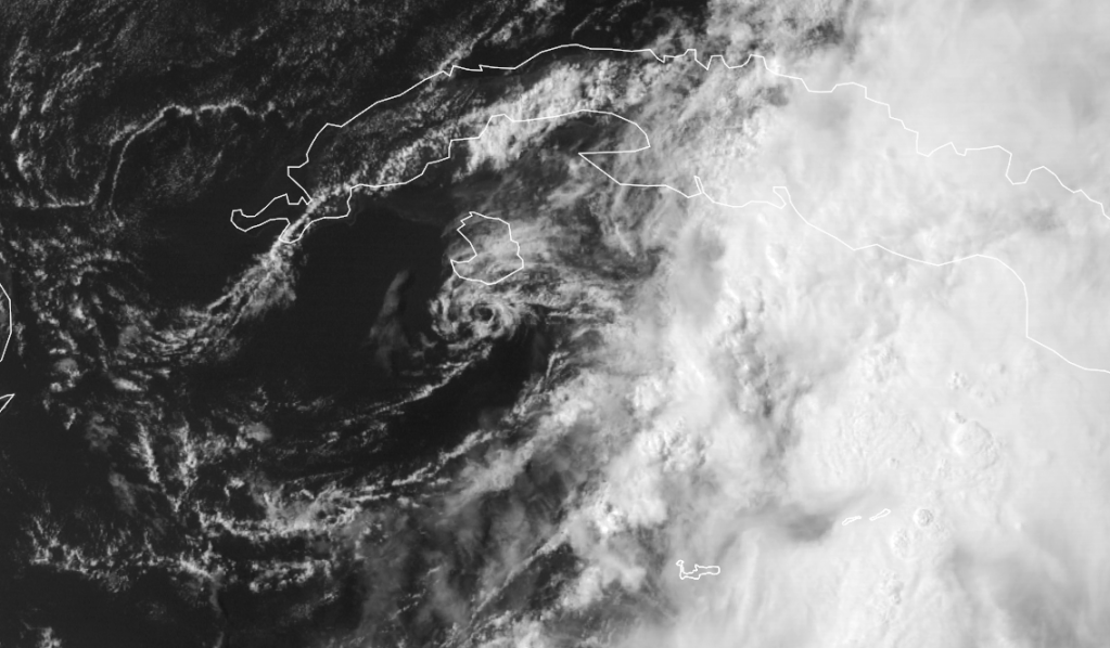
Low pressure, designated Invest 94-L, was located near the south coast of Cuba this morning. Satellite imagery showed some deeper convection firing in an area between Jamaica and the south coast of Cuba, however, the convection is not organized or consolidated. Additionally, satellite loops showed that most of the convection is occurring on the eastern side of the low pressure system.
As of early this morning, wind shear values across the northern Caribbean are running between 20 and 30 knots and I do not think we will see any type of development from it until it is north of the Bahamas just off of the US Southeast coast on Friday and into Saturday.
All of the global model suite is now in agreement surrounding both the development of a sub-tropical or tropical storm this weekend off of the US Southeast coast and the track of this storm which looks to be southwestward into northeastern Florida or far southern Georgia on Monday morning. It should be pointed out that both the GFS and European model guidance are forecasting a storm that is quite a bit larger in size than Alberto.
The European model guidance, which is my forecast model of choice, is fairly aggressive with development of what could be Beryl. It forecasts a southwestward track this weekend and forecasts this storm to make landfall very near Saint Augustine and Palm Coast in northeast Florida on Monday morning. From there, the European model forecasts that this storm will come inland into northern Florida during the day Monday before tracking northeastward back into the Atlantic just south and east of the North Carolina coast during Tuesday and Wednesday of next week as an eastward moving frontal system picks it up.
So, my thinking is that Invest 94-L will track north-northeastward today and tonight from the south coast of Cuba and across the northwestern Bahamas. Most of the moisture and convection with this system is on the eastern side, so most of the Bahamas are in for a pretty stormy day with heavy rainfall and thunderstorms while most of the Florida peninsula should stay fairly dry, although the normal scattered afternoon thunderstorms are expected across central and south Florida this afternoon.
By Friday into Saturday, I think we will see Invest 94-L spin up into a tropical entity and I suspect it will be Tropical Storm Beryl as it first tracks north and then westward just off of the Georgia coast. Tropical Storm to be Beryl is then expected to push southwestward along the Georgia coast on Sunday before coming ashore in northeastern Florida near Saint Augustine and Palm Coast on Memorial Day.
Needless to say, I will be monitoring Invest 94-L very closely and will update all of you as conditions warrant.
The following post is NOT an official forecast and should not be used as such. It is just the opinion of the poster and may or may not be backed by sound meteorological data. It is NOT endorsed by any professional institution including storm2k.org. For Official Information please refer to the NHC and NWS products.
http://www.crownweather.com/?page_id=4557
Tropical/Sub Tropical Storm Beryl Likely To Develop This Weekend Off Of US Southeast Coast:
It is looking more and more likely that we will have Sub-Tropical or Tropical Storm Beryl located off of the Southeastern coast of the United States during the Memorial Day weekend. Should this happen, it will be the first time we have had two named tropical storms before June 1st since 1887.
Low pressure, designated Invest 94-L, was located near the south coast of Cuba this morning. Satellite imagery showed some deeper convection firing in an area between Jamaica and the south coast of Cuba, however, the convection is not organized or consolidated. Additionally, satellite loops showed that most of the convection is occurring on the eastern side of the low pressure system.
As of early this morning, wind shear values across the northern Caribbean are running between 20 and 30 knots and I do not think we will see any type of development from it until it is north of the Bahamas just off of the US Southeast coast on Friday and into Saturday.
All of the global model suite is now in agreement surrounding both the development of a sub-tropical or tropical storm this weekend off of the US Southeast coast and the track of this storm which looks to be southwestward into northeastern Florida or far southern Georgia on Monday morning. It should be pointed out that both the GFS and European model guidance are forecasting a storm that is quite a bit larger in size than Alberto.
The European model guidance, which is my forecast model of choice, is fairly aggressive with development of what could be Beryl. It forecasts a southwestward track this weekend and forecasts this storm to make landfall very near Saint Augustine and Palm Coast in northeast Florida on Monday morning. From there, the European model forecasts that this storm will come inland into northern Florida during the day Monday before tracking northeastward back into the Atlantic just south and east of the North Carolina coast during Tuesday and Wednesday of next week as an eastward moving frontal system picks it up.
So, my thinking is that Invest 94-L will track north-northeastward today and tonight from the south coast of Cuba and across the northwestern Bahamas. Most of the moisture and convection with this system is on the eastern side, so most of the Bahamas are in for a pretty stormy day with heavy rainfall and thunderstorms while most of the Florida peninsula should stay fairly dry, although the normal scattered afternoon thunderstorms are expected across central and south Florida this afternoon.
By Friday into Saturday, I think we will see Invest 94-L spin up into a tropical entity and I suspect it will be Tropical Storm Beryl as it first tracks north and then westward just off of the Georgia coast. Tropical Storm to be Beryl is then expected to push southwestward along the Georgia coast on Sunday before coming ashore in northeastern Florida near Saint Augustine and Palm Coast on Memorial Day.
Needless to say, I will be monitoring Invest 94-L very closely and will update all of you as conditions warrant.
0 likes
Visit the Caribbean-Central America Weather Thread where you can find at first post web cams,radars
and observations from Caribbean basin members Click Here
and observations from Caribbean basin members Click Here
Melbourne's AFD this morning:
http://forecast.weather.gov/product.php ... glossary=0
AREA FORECAST DISCUSSION
NATIONAL WEATHER SERVICE MELBOURNE FL
407 AM EDT THU MAY 24 2012
SUN-WED...AN UPPER LEVEL RIDGE EXTENDING EASTWARD OFF THE MID
ATLANTIC COAST EARLY IN THE WEEKEND HALTS THE NORTHEASTWARD MOVEMENT
OF THE LOW OVER THE WEST ATLANTIC. THIS ALLOWS THE SYSTEM TO
RETROGRADE BACK TOWARD THE FL PENINSULA SUNDAY. FROM THIS POINT IN
THE FORECAST MORE EXACT DETAILS REMAIN UNCLEAR AS SIGNIFICANT RUN TO
RUN INCONSISTENCIES AND MODEL DIFFERENCES STILL EXIST WITH THE TRACK
AND STRENGTH OF THIS LOW. HAVE LEANED TOWARD THE 00Z GFS WHICH HAS
SHOWN BETTER CONSISTENCY AND HAS THE MORE PREFERRED SOLUTION OF A
WESTWARD TRACK OF THIS SYSTEM ACROSS THE PENINSULA. IF THIS TYPE OF
TRACK HOLDS WITH FUTURE MODEL RUNS THEN CHANCES FOR HEAVY RAINFALL
AND GUSTY WINDS ACROSS THE REGION WILL INCREASE THIS MEMORIAL DAY
WEEKEND.
THE GFS HAS THE SYSTEM WEAKENING AND SHIFTING WESTWARD INTO THE
NORTHEAST GULF INTO EARLY NEXT WEEK. HOWEVER DEEP MOISTURE LOOKS TO
REMAIN OVER THE REGION WITH RAIN CHANCES REMAINING ELEVATED. FOR NOW
WILL KEEP RAIN CHANCES CLOSE TO MEX GUIDANCE IN THE EXTENDED...
AROUND 40 PERCENT. HOWEVER THESE MAY NEED TO BE RAISED IN SUBSEQUENT
FORECASTS IF MODEL TRENDS HOLD. CONTINUE TO MONITOR FOR LATEST
UPDATES ON THIS POTENTIAL HOLIDAY WEEKEND SYSTEM.
http://forecast.weather.gov/product.php ... glossary=0
0 likes
-
ocala
- Tropical Depression

- Posts: 88
- Joined: Sat Apr 08, 2006 8:48 am
- Location: Candler,Florida
- Contact:
Re: ATL: INVEST 94L
Man this is great news if this forecast holds true. Central and North Florida need bucket loads of rain.
0 likes
-
northjaxpro
- S2K Supporter
- Posts: 8900
- Joined: Mon Sep 27, 2010 11:21 am
- Location: Jacksonville, FL
Re: ATL: INVEST 94L
ocala wrote:Man this is great news if this forecast holds true. Central and North Florida need bucket loads of rain.
Amen! This is absolutely what we need, a tropical entity which will dump a lot of rain into this region. Here at my location, I am still about about 8 -10 inches below the average rainfall for this time of year. If the forecast holds from the models, this indeed would be an absolute Godsend for sure for North and Central Florida.
Also, looking at the first visible satellite images of the day, it appears that there is a circulation just off the north coast of Cuba moving north-northeast entering the Florida Straits.

0 likes
NEVER, EVER SAY NEVER in the tropics and weather in general, and most importantly, with life itself!!
________________________________________________________________________________________
Fay 2008 Beryl 2012 Debby 2012 Colin 2016 Hermine 2016 Julia 2016 Matthew 2016 Irma 2017 Dorian 2019
________________________________________________________________________________________
Fay 2008 Beryl 2012 Debby 2012 Colin 2016 Hermine 2016 Julia 2016 Matthew 2016 Irma 2017 Dorian 2019
Who is online
Users browsing this forum: No registered users and 16 guests