Pretty good run to run consistency with the euro. basically the same track. but 00z had a NE florida landfall and held together a little better. Looks like 1000 MB at landfall
The Low itself is in the florida straights now as well. according to some models a separate low develops farther north which eventually transitions.
http://www.ssd.noaa.gov/goes/east/gmex/loop-rgb.html
ATL: BERYL - Post-Tropical
Moderator: S2k Moderators
-
Aric Dunn
- Category 5

- Posts: 21238
- Age: 43
- Joined: Sun Sep 19, 2004 9:58 pm
- Location: Ready for the Chase.
- Contact:
0 likes
Note: If I make a post that is brief. Please refer back to previous posts for the analysis or reasoning. I do not re-write/qoute what my initial post said each time.
If there is nothing before... then just ask
Space & Atmospheric Physicist, Embry-Riddle Aeronautical University,
I believe the sky is falling...
If there is nothing before... then just ask
Space & Atmospheric Physicist, Embry-Riddle Aeronautical University,
I believe the sky is falling...
-
northjaxpro

- S2K Supporter

- Posts: 8900
- Joined: Mon Sep 27, 2010 11:21 am
- Location: Jacksonville, FL
Aric, I was one who also intially considered the Euro an outlier in previous runs in really spinning up this system in 72 hours, but I am beginning to think the Euro may be on to something. Euro has been depicting a more robust system to form just north of the Bahamas beginning Saturday. Development will be similar set-up to what we had with Alberto, but this system has a much larger tropical envelope feed which should enable it to be a significantly bigger system than Alberto for sure.
Last edited by northjaxpro on Thu May 24, 2012 7:30 am, edited 1 time in total.
0 likes
NEVER, EVER SAY NEVER in the tropics and weather in general, and most importantly, with life itself!!
________________________________________________________________________________________
Fay 2008 Beryl 2012 Debby 2012 Colin 2016 Hermine 2016 Julia 2016 Matthew 2016 Irma 2017 Dorian 2019
________________________________________________________________________________________
Fay 2008 Beryl 2012 Debby 2012 Colin 2016 Hermine 2016 Julia 2016 Matthew 2016 Irma 2017 Dorian 2019
-
Aric Dunn
- Category 5
- Posts: 21238
- Age: 43
- Joined: Sun Sep 19, 2004 9:58 pm
- Location: Ready for the Chase.
- Contact:
Re:
northjaxpro wrote:Aric, I was one who also intially considered the Euro an outlier in previous runs in really spinning up this system in 72 hours, but I am beginning to think the Euro may be on to something. Euro has been depicting a more robust system to form just north of the Bahamas beginning Saturday. Development will be similar set-up to what we had with Alberto, but this system has a much larger tropical envelope feed which enable it to be a significantly bigger system than Alberto for sure.
from what the models are saying dry air will not be as much of a problem this go around.
0 likes
Note: If I make a post that is brief. Please refer back to previous posts for the analysis or reasoning. I do not re-write/qoute what my initial post said each time.
If there is nothing before... then just ask
Space & Atmospheric Physicist, Embry-Riddle Aeronautical University,
I believe the sky is falling...
If there is nothing before... then just ask
Space & Atmospheric Physicist, Embry-Riddle Aeronautical University,
I believe the sky is falling...
-
Aric Dunn
- Category 5
- Posts: 21238
- Age: 43
- Joined: Sun Sep 19, 2004 9:58 pm
- Location: Ready for the Chase.
- Contact:
Looks like SE florida is about the get a whole lot of rain today.
whole lot of moisture return over the florida peninsula .... http://tropic.ssec.wisc.edu/real-time/m ... /main.html
whole lot of moisture return over the florida peninsula .... http://tropic.ssec.wisc.edu/real-time/m ... /main.html
0 likes
Note: If I make a post that is brief. Please refer back to previous posts for the analysis or reasoning. I do not re-write/qoute what my initial post said each time.
If there is nothing before... then just ask
Space & Atmospheric Physicist, Embry-Riddle Aeronautical University,
I believe the sky is falling...
If there is nothing before... then just ask
Space & Atmospheric Physicist, Embry-Riddle Aeronautical University,
I believe the sky is falling...
-
cycloneye

- Admin

- Posts: 149275
- Age: 69
- Joined: Thu Oct 10, 2002 10:54 am
- Location: San Juan, Puerto Rico
Re: ATL: INVEST 94L
SPECIAL TROPICAL WEATHER OUTLOOK
NWS NATIONAL HURRICANE CENTER MIAMI FL
840 AM EDT THU MAY 24 2012
FOR THE NORTH ATLANTIC...CARIBBEAN SEA AND THE GULF OF MEXICO...
AN ELONGATED AREA OF LOW PRESSURE EXTENDING FROM THE NORTHWESTERN
CARIBBEAN SEA ACROSS WESTERN CUBA AND INTO THE FLORIDA STRAITS IS
ASSOCIATED WITH A LARGE AREA OF DISORGANIZED SHOWER AND
THUNDERSTORM ACTIVITY. CURRENTLY THE SYSTEM LACKS A WELL-DEFINED
CIRCULATION CENTER...AND ENVIRONMENTAL CONDITIONS ARE NOT EXPECTED
TO BE CONDUCIVE FOR SIGNIFICANT DEVELOPMENT OF THIS SYSTEM DURING
THE NEXT DAY OR SO. THIS SYSTEM HAS A LOW CHANCE...20 PERCENT...OF
BECOMING A TROPICAL OR SUBTROPICAL CYCLONE DURING THE NEXT 48 HOURS
AS IT MOVES NORTHEASTWARD ACROSS THE BAHAMAS AND INTO THE
SOUTHWESTERN ATLANTIC OCEAN.
ALTHOUGH CONDITIONS ARE NOT CURRENTLY FAVORABLE FOR DEVELOPMENT...
THEY ARE EXPECTED TO BECOME MORE CONDUCIVE FOR THE FORMATION OF A
SUBTROPICAL OR TROPICAL CYCLONE BY LATE SATURDAY OR SUNDAY.
REGARDLESS OF ANY DEVELOPMENT...LOCALLY HEAVY RAINFALL AND FLOODING
ARE POSSIBLE OVER THE CAYMAN ISLANDS...PORTIONS OF CUBA...SOUTHERN
FLORIDA...AND THE BAHAMAS. ANOTHER SPECIAL TROPICAL WEATHER OUTLOOK
FOR THIS SYSTEM WILL BE ISSUED ON FRIDAY. FOR ADDITIONAL
INFORMATION ON THIS SYSTEM...PLEASE SEE HIGH SEAS FORECASTS ISSUED
BY THE NATIONAL WEATHER SERVICE...AND PRODUCTS FROM YOUR LOCAL
WEATHER OFFICE.
ELSEWHERE...TROPICAL CYCLONE FORMATION IS NOT EXPECTED DURING THE
NEXT 48 HOURS.
&&
HIGH SEAS FORECASTS ISSUED BY THE NATIONAL WEATHER SERVICE CAN BE
FOUND UNDER AWIPS HEADER NFDHSFAT1 AND WMO HEADER FZNT01 KWBC.
$$
FORECASTER BRENNAN/BERG
0 likes
Visit the Caribbean-Central America Weather Thread where you can find at first post web cams,radars
and observations from Caribbean basin members Click Here
and observations from Caribbean basin members Click Here
-
gatorcane

- S2K Supporter
- Posts: 23708
- Age: 48
- Joined: Sun Mar 13, 2005 3:54 pm
- Location: Boca Raton, FL
Indeed as was my thinking a couple of days ago, slow development would be possible.
Expecting it remain quite sheared as it moves slowly into or near South FL then into the Bahamas but nonetheless quite impressive we already have our second possible system and its not even June.
Expecting it remain quite sheared as it moves slowly into or near South FL then into the Bahamas but nonetheless quite impressive we already have our second possible system and its not even June.
Last edited by gatorcane on Thu May 24, 2012 7:57 am, edited 3 times in total.
0 likes
-
Aric Dunn
- Category 5
- Posts: 21238
- Age: 43
- Joined: Sun Sep 19, 2004 9:58 pm
- Location: Ready for the Chase.
- Contact:
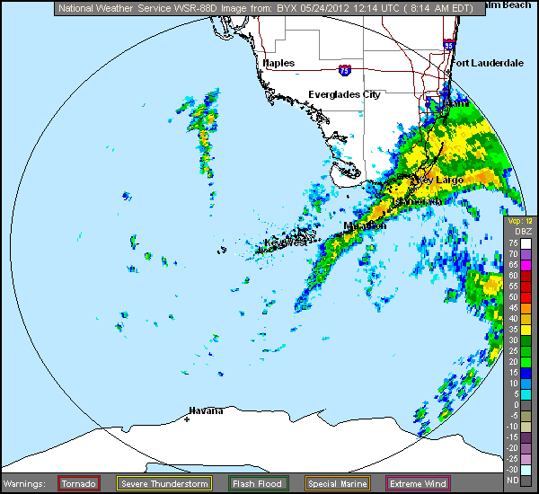
Sure does seem like this low over the straights is going to maintain. track would take it across SE Florida exiting near west palm tomorrow ( which is a little to the left than the models). looking at the trends from the last 12 hours from TPW there may be a lot more in the way of substantial rain fall farther up the coast.
0 likes
Note: If I make a post that is brief. Please refer back to previous posts for the analysis or reasoning. I do not re-write/qoute what my initial post said each time.
If there is nothing before... then just ask
Space & Atmospheric Physicist, Embry-Riddle Aeronautical University,
I believe the sky is falling...
If there is nothing before... then just ask
Space & Atmospheric Physicist, Embry-Riddle Aeronautical University,
I believe the sky is falling...

-
cycloneye
- Admin
- Posts: 149275
- Age: 69
- Joined: Thu Oct 10, 2002 10:54 am
- Location: San Juan, Puerto Rico
Re: ATL: INVEST 94L: Special Tropical Weather Outlook=20%
12z Best Track
AL, 94, 2012052412, , BEST, 0, 238N, 811W, 25, 1009, LO
http://ftp.nhc.noaa.gov/atcf/tcweb/inve ... 012.invest
AL, 94, 2012052412, , BEST, 0, 238N, 811W, 25, 1009, LO
http://ftp.nhc.noaa.gov/atcf/tcweb/inve ... 012.invest
0 likes
Visit the Caribbean-Central America Weather Thread where you can find at first post web cams,radars
and observations from Caribbean basin members Click Here
and observations from Caribbean basin members Click Here
-
otowntiger
- Category 5
- Posts: 1932
- Joined: Tue Aug 31, 2004 7:06 pm
Re:
I hope that whatever becomes of this system it would be kind enough to send some rain up here in interior central Florida and not draw out the moisture ala Alberto. We're as dry as a bone and a significant wildfire threat continues to loom. Not to mention my water bill is ridiculous trying to keep my landscape alive.Aric Dunn wrote:Sure does seem like this low over the straights is going to maintain. track would take it across SE Florida exiting near west palm tomorrow ( which is a little to the left than the models). looking at the trends from the last 12 hours from TPW there may be a lot more in the way of substantial rain fall farther up the coast.
0 likes
-
tolakram
- Admin
- Posts: 20178
- Age: 62
- Joined: Sun Aug 27, 2006 8:23 pm
- Location: Florence, KY (name is Mark)
Re: ATL: INVEST 94L: Special Tropical Weather Outlook=20%

0 likes
M a r k
- - - - -
Join us in chat: Storm2K Chatroom Invite. Android and IOS apps also available.
The posts in this forum are NOT official forecasts and should not be used as such. Posts are NOT endorsed by any professional institution or STORM2K.org. For official information and forecasts, please refer to NHC and NWS products.
-
Aric Dunn
- Category 5
- Posts: 21238
- Age: 43
- Joined: Sun Sep 19, 2004 9:58 pm
- Location: Ready for the Chase.
- Contact:
interestingly the flow here in central florida has shifted from a southerly to a more ese flow. likely do to the low in the straights deepening. all yesterday the low was very elongated with multiple vorts today however that has changed. its still not well defined but there is a much larger circulation pattern developing. Its starting to push moisture here into central florida at least in the low levels.
0 likes
Note: If I make a post that is brief. Please refer back to previous posts for the analysis or reasoning. I do not re-write/qoute what my initial post said each time.
If there is nothing before... then just ask
Space & Atmospheric Physicist, Embry-Riddle Aeronautical University,
I believe the sky is falling...
If there is nothing before... then just ask
Space & Atmospheric Physicist, Embry-Riddle Aeronautical University,
I believe the sky is falling...
-
JonathanBelles
- Professional-Met

- Posts: 11430
- Age: 35
- Joined: Sat Dec 24, 2005 9:00 pm
- Location: School: Florida State University (Tallahassee, FL) Home: St. Petersburg, Florida
- Contact:
Re:
Aric Dunn wrote:interestingly the flow here in central florida has shifted from a southerly to a more ese flow. likely do to the low in the straights deepening. all yesterday the low was very elongated with multiple vorts today however that has changed. its still not well defined but there is a much larger circulation pattern developing. Its starting to push moisture here into central florida at least in the low levels.
A light easterly breeze here in St. Pete blowing in the window. Yesterday it was mainly out of the north.
0 likes

Re: Re:
[quote="otowntiger"]8-) [quote="Aric Dunn"]Sure does seem like this low over the straights is going to maintain. track would take it across SE Florida exiting near west palm tomorrow ( which is a little to the left than the models). looking at the trends from the last 12 hours from TPW there may be a lot more in the way of substantial rain fall farther up the coast.[/quote] I hope that whatever becomes of this system it would be kind enough to send some rain up here in interior central Florida and not draw out the moisture ala Alberto. We're as dry as a bone and a significant wildfire threat continues to loom. Not to mention my water bill is ridiculous trying to keep my landscape alive.[/quote]
I feel your pain Otown...we are bone dry up here in the Panhandle as well and for a minute I thought we might be able to get some much needed moisture from whatever this turns out to be but now it appears that it is not going to push far enough west to give us anything.
I feel your pain Otown...we are bone dry up here in the Panhandle as well and for a minute I thought we might be able to get some much needed moisture from whatever this turns out to be but now it appears that it is not going to push far enough west to give us anything.
0 likes
-
Nikki

- S2K Supporter
- Posts: 291
- Joined: Mon Jun 21, 2010 3:38 pm
- Location: Santa Fe, TX (yes I typed that right TEXAS not New Mexico, I am about 20 miles from Galveston, TX)
Re: ATL: INVEST 94L
ZCZC MIATWOAT ALL
TTAA00 KNHC DDHHMM
SPECIAL TROPICAL WEATHER OUTLOOK
NWS NATIONAL HURRICANE CENTER MIAMI FL
840 AM EDT THU MAY 24 2012
FOR THE NORTH ATLANTIC...CARIBBEAN SEA AND THE GULF OF MEXICO...
1. AN ELONGATED AREA OF LOW PRESSURE EXTENDING FROM THE NORTHWESTERN
CARIBBEAN SEA ACROSS WESTERN CUBA AND INTO THE FLORIDA STRAITS IS
ASSOCIATED WITH A LARGE AREA OF DISORGANIZED SHOWER AND
THUNDERSTORM ACTIVITY. CURRENTLY THE SYSTEM LACKS A WELL-DEFINED
CIRCULATION CENTER...AND ENVIRONMENTAL CONDITIONS ARE NOT EXPECTED
TO BE CONDUCIVE FOR SIGNIFICANT DEVELOPMENT OF THIS SYSTEM DURING
THE NEXT DAY OR SO. THIS SYSTEM HAS A LOW CHANCE...20 PERCENT...OF
BECOMING A TROPICAL OR SUBTROPICAL CYCLONE DURING THE NEXT 48 HOURS
AS IT MOVES NORTHEASTWARD ACROSS THE BAHAMAS AND INTO THE
SOUTHWESTERN ATLANTIC OCEAN.
ALTHOUGH CONDITIONS ARE NOT CURRENTLY FAVORABLE FOR DEVELOPMENT...
THEY ARE EXPECTED TO BECOME MORE CONDUCIVE FOR THE FORMATION OF A
SUBTROPICAL OR TROPICAL CYCLONE BY LATE SATURDAY OR SUNDAY.
REGARDLESS OF ANY DEVELOPMENT...LOCALLY HEAVY RAINFALL AND FLOODING
ARE POSSIBLE OVER THE CAYMAN ISLANDS...PORTIONS OF CUBA...SOUTHERN
FLORIDA...AND THE BAHAMAS. ANOTHER SPECIAL TROPICAL WEATHER OUTLOOK
FOR THIS SYSTEM WILL BE ISSUED ON FRIDAY. FOR ADDITIONAL
INFORMATION ON THIS SYSTEM...PLEASE SEE HIGH SEAS FORECASTS ISSUED
BY THE NATIONAL WEATHER SERVICE...AND PRODUCTS FROM YOUR LOCAL
WEATHER OFFICE.
ELSEWHERE...TROPICAL CYCLONE FORMATION IS NOT EXPECTED DURING THE
NEXT 48 HOURS.
&&
HIGH SEAS FORECASTS ISSUED BY THE NATIONAL WEATHER SERVICE CAN BE
FOUND UNDER AWIPS HEADER NFDHSFAT1 AND WMO HEADER FZNT01 KWBC.
$$
FORECASTER BRENNAN/BERG
NNNN
0 likes
My name is Nicole and this is what I go by in Storm2k chat! Come chat with us! We have fun in there too!!
A teacher's purpose is not to create students in her own image, but to develop students who can create their own image. ~Author Unknown
Alicia, Allison, Rita, Ike
A teacher's purpose is not to create students in her own image, but to develop students who can create their own image. ~Author Unknown
Alicia, Allison, Rita, Ike
-
Aric Dunn
- Category 5
- Posts: 21238
- Age: 43
- Joined: Sun Sep 19, 2004 9:58 pm
- Location: Ready for the Chase.
- Contact:
The circ is just about right over the middle keys. seems its becoming more defined pretty quick now with much more in the way of a west wind component . it should track over SE florida today leaving around west palm.
very close sat loop. you can turn on the radar overlay.
http://www.ssd.noaa.gov/goes/east/wfo/e ... h-rgb.html
very close sat loop. you can turn on the radar overlay.
http://www.ssd.noaa.gov/goes/east/wfo/e ... h-rgb.html
0 likes
Note: If I make a post that is brief. Please refer back to previous posts for the analysis or reasoning. I do not re-write/qoute what my initial post said each time.
If there is nothing before... then just ask
Space & Atmospheric Physicist, Embry-Riddle Aeronautical University,
I believe the sky is falling...
If there is nothing before... then just ask
Space & Atmospheric Physicist, Embry-Riddle Aeronautical University,
I believe the sky is falling...

-
northjaxpro
- S2K Supporter
- Posts: 8900
- Joined: Mon Sep 27, 2010 11:21 am
- Location: Jacksonville, FL
Considering that 94L has been fighting against shear up to 40 knots for its lifespan to this point, I think it is remarkable that the circulation is relatively still rather well-defined at this time.
0 likes
NEVER, EVER SAY NEVER in the tropics and weather in general, and most importantly, with life itself!!
________________________________________________________________________________________
Fay 2008 Beryl 2012 Debby 2012 Colin 2016 Hermine 2016 Julia 2016 Matthew 2016 Irma 2017 Dorian 2019
________________________________________________________________________________________
Fay 2008 Beryl 2012 Debby 2012 Colin 2016 Hermine 2016 Julia 2016 Matthew 2016 Irma 2017 Dorian 2019
-
Aric Dunn
- Category 5
- Posts: 21238
- Age: 43
- Joined: Sun Sep 19, 2004 9:58 pm
- Location: Ready for the Chase.
- Contact:
Re:
northjaxpro wrote:Considering that 94L has been fighting against shear up to 40 knots for its lifespan to this point, I think it is remarkable that the circulation is relatively still rather well-defined at this time.
Im still curious. if this low does hold together instead of another developing farther north. well i guess the question is... is this broad circ tropical atm or not. I would assume the temperature profile is warm core. then in that case it would not necessarily have to transition. rather the environment would just have to become more conducive for organized convection.
0 likes
Note: If I make a post that is brief. Please refer back to previous posts for the analysis or reasoning. I do not re-write/qoute what my initial post said each time.
If there is nothing before... then just ask
Space & Atmospheric Physicist, Embry-Riddle Aeronautical University,
I believe the sky is falling...
If there is nothing before... then just ask
Space & Atmospheric Physicist, Embry-Riddle Aeronautical University,
I believe the sky is falling...
-
northjaxpro
- S2K Supporter
- Posts: 8900
- Joined: Mon Sep 27, 2010 11:21 am
- Location: Jacksonville, FL
HPC surface analysis has 1009 mb Low (94L) intialized just south of the middle Keys

0 likes
NEVER, EVER SAY NEVER in the tropics and weather in general, and most importantly, with life itself!!
________________________________________________________________________________________
Fay 2008 Beryl 2012 Debby 2012 Colin 2016 Hermine 2016 Julia 2016 Matthew 2016 Irma 2017 Dorian 2019
________________________________________________________________________________________
Fay 2008 Beryl 2012 Debby 2012 Colin 2016 Hermine 2016 Julia 2016 Matthew 2016 Irma 2017 Dorian 2019
Who is online
Users browsing this forum: No registered users and 27 guests