
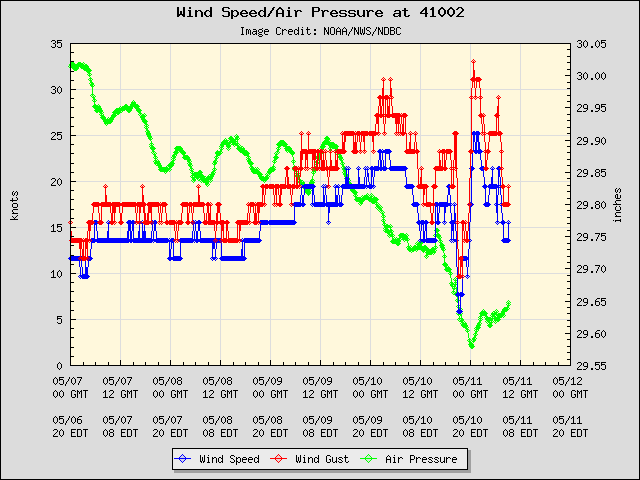
Check out the winds from the buoy Aric posted just a few miles north of the circulation!
This could get upgraded in just hours, IMO.
Conditions at 41002 as of
(2:50 pm EDT)
1850 GMT on 05/25/2012:
Wind Direction (WDIR): ESE ( 120 deg true )
Wind Speed (WSPD): 31.1 kts
Wind Gust (GST): 38.9 kts
Wave Height (WVHT): 7.9 ft
Dominant Wave Period (DPD): 8 sec
Average Period (APD): 6.0 sec
Mean Wave Direction (MWD): SE ( 143 deg true )
Atmospheric Pressure (PRES): 29.79 in
Pressure Tendency (PTDY): -0.13 in ( Falling Rapidly )
Air Temperature (ATMP): 74.8 °F
Water Temperature (WTMP): 77.9 °F
Dew Point (DEWP): 74.7 °F
Combined plot of Wind Speed, Gust, and Air Pressure
ATL: BERYL - Post-Tropical
Moderator: S2k Moderators
-
tolakram
- Admin

- Posts: 20179
- Age: 62
- Joined: Sun Aug 27, 2006 8:23 pm
- Location: Florence, KY (name is Mark)
Re: ATL:INVEST 94L:Special Tropical Weather Outlook=Code Red-80%
10 frame live visible loop: http://wwwghcc.msfc.nasa.gov/cgi-bin/ge ... mframes=10
Sped up you can really see what looks like an LLC getting organized. Could this be mid-level instead?
Sped up you can really see what looks like an LLC getting organized. Could this be mid-level instead?
0 likes
M a r k
- - - - -
Join us in chat: Storm2K Chatroom Invite. Android and IOS apps also available.
The posts in this forum are NOT official forecasts and should not be used as such. Posts are NOT endorsed by any professional institution or STORM2K.org. For official information and forecasts, please refer to NHC and NWS products.
-
Aric Dunn
- Category 5

- Posts: 21238
- Age: 43
- Joined: Sun Sep 19, 2004 9:58 pm
- Location: Ready for the Chase.
- Contact:
Re: ATL:INVEST 94L:Special Tropical Weather Outlook=Code Red-80%
tolakram wrote:10 frame live visible loop: http://wwwghcc.msfc.nasa.gov/cgi-bin/ge ... mframes=10
Sped up you can really see what looks like an LLC getting organized. Could this be mid-level instead?
unlikely there are surface obs to support it.
0 likes
Note: If I make a post that is brief. Please refer back to previous posts for the analysis or reasoning. I do not re-write/qoute what my initial post said each time.
If there is nothing before... then just ask
Space & Atmospheric Physicist, Embry-Riddle Aeronautical University,
I believe the sky is falling...
If there is nothing before... then just ask
Space & Atmospheric Physicist, Embry-Riddle Aeronautical University,
I believe the sky is falling...
-
northjaxpro

- S2K Supporter

- Posts: 8900
- Joined: Mon Sep 27, 2010 11:21 am
- Location: Jacksonville, FL
Re:
TropicalAnalystwx13 wrote:The posts in this forum are NOT official forecast and should not be used as such. They are just the opinion of the poster and may or may not be backed by sound meteorological data. They are NOT endorsed by any professional institution or storm2k.org. For official information, please refer to the NHC and NWS products.[/QUOTE]
I believe the system will be upgraded to Tropical Storm Beryl tomorrow afternoon after recon investigates. By then, it should be fully stacked with the upper level disturbance/low to its northwest and should be in a low wind shear environment. Gradual strengthening is expected tomorrow and tomorrow night, followed by slow weakening as the system approaches the FL/GA border due to the effects of the shelf waters. At this time, I am forecasting a peak intensity of 60 knots--give or take 5 mph. If 94L tries enough, it could briefly become a hurricane. Overall, the environment is more conducive than with Alberto, so a 60 mph+ peak is definitely likely.
This is a pretty good analysis. Interesting next few days shaping up down here that's for sure.
0 likes
NEVER, EVER SAY NEVER in the tropics and weather in general, and most importantly, with life itself!!
________________________________________________________________________________________
Fay 2008 Beryl 2012 Debby 2012 Colin 2016 Hermine 2016 Julia 2016 Matthew 2016 Irma 2017 Dorian 2019
________________________________________________________________________________________
Fay 2008 Beryl 2012 Debby 2012 Colin 2016 Hermine 2016 Julia 2016 Matthew 2016 Irma 2017 Dorian 2019
Re: ATL:INVEST 94L:Special Tropical Weather Outlook=Code Red-80%
Not convinced yet as to where final Low Center ends up
Is it possible energy tranferred back south - and forms near N. Bahamas ?
Almost looks like the "base" forming there, and slight turning - but not sure
http://www.ssec.wisc.edu/data/geo/index ... thod=flash
Is it possible energy tranferred back south - and forms near N. Bahamas ?
Almost looks like the "base" forming there, and slight turning - but not sure
http://www.ssec.wisc.edu/data/geo/index ... thod=flash
0 likes
-
TropicalAnalystwx13

- Category 5
- Posts: 2109
- Age: 28
- Joined: Tue Jul 19, 2011 8:20 pm
- Location: Wilmington, NC
- Contact:
Tropical Cyclone Formation Alert
ALERT ATCF MIL 94X XXX 120525000000
2012052500
26.5 281.4
33.5 285.0
100
26.5 281.4
250200
1205250200
1
SUBJ/TROPICAL CYCLONE FORMATION ALERT//
WTNT21 KNGU 250200
RMKS/1. FORMATION OF A SIGNIFICANT TROPICAL CYCLONE IS POSSIBLE WITHIN
100 NM EITHER SIDE OF A LINE FROM 26.5N 78.6W TO 33.5N 75.0W
WITHIN THE NEXT 12 TO 24 HOURS. AVAILABLE DATA DOES NOT JUSTIFY
ISSUANCE OF NUMBERED TROPICAL CYCLONE WARNINGS AT THIS TIME. WINDS IN
THE AREA ARE ESTIMATED TO BE 10 TO 15 KNOTS. THE SYSTEM IS MOVING
NORTHEASTWARD AT 19 KNOTS.
2. REMARKS: THE LOW HAS BECOME BETTER DEFINED HOWEVER THE
SHOWERS/THUNDERSTORMS PERSISTING OVER THIS AREA HAVE REMAINED
DISORGANIZED DUE TO THE UNFAVORABLE HIGH WIND SHEAR ENVIRONMENT
CURRENTLY INFLUENCING THE SYSTEM. UPPER LEVEL WIND SHEAR IS EXPECTED
TO DECREASE TO ALLOW FURTHER DEVELOPMENT WITHIN 24 TO 48 HOURS.
ADDITIONALLY, WARM SEA SURFACE TEMPERATURES OF 80 TO 82 DEGREES FAHRENHEIT
MAY ENHANCE DEVELOPMENT OF THIS SYSTEM.
3. THIS ALERT WILL BE UPGRADED TO A WARNING OR REISSUED AS REQUIRED
BY 260200Z.//
9412052200 180N 860W 20
9412052206 180N 854W 20
9412052212 181N 849W 20
9412052218 185N 845W 25
9412052300 190N 841W 25
9412052306 196N 839W 25
9412052312 201N 835W 25
9412052318 206N 830W 25
9412052400 214N 824W 30
9412052406 227N 817W 25
9412052412 238N 813W 25
9412052418 251N 801W 35
9412052500 265N 786W 35
0 likes
Re: ATL:INVEST 94L:Special Tropical Weather Outlook=Code Red-80%
crimi481 wrote:Not convinced yet as to where final Low Center ends up
Is it possible energy tranferred back south - and forms near N. Bahamas ?
Almost looks like the "base" forming there, and slight turning - but not sure
http://www.ssec.wisc.edu/data/geo/index ... thod=flash
Reforming back south near the northern Bahamas? Not at all.
If you do not want to look like a fool do not go against the best models, the euro and the gfs, in a short range forecast.
0 likes

Re: ATL: INVEST 94L: STWO=Code Red-80% / TCFA issued
Does 94L have a greater chance of becoming tropical rather than subtropical now? I noticed the wording in the outlook mentioned tropical development first over subtropical.
0 likes
-
cycloneye

- Admin
- Posts: 149278
- Age: 69
- Joined: Thu Oct 10, 2002 10:54 am
- Location: San Juan, Puerto Rico
Re: ATL: INVEST 94L: STWO=Code Red-80% / TCFA issued
bg1 wrote:Does 94L have a greater chance of becoming tropical rather than subtropical now? I noticed the wording in the outlook mentioned tropical development first over subtropical.
At this time,dvorak SSD T Numbers are at ST,but that could change later.
25/1745 UTC 31.0N 75.0W ST1.5 94L -- Atlantic
http://www.ssd.noaa.gov/PS/TROP/tdpositions.html
0 likes
Visit the Caribbean-Central America Weather Thread where you can find at first post web cams,radars
and observations from Caribbean basin members Click Here
and observations from Caribbean basin members Click Here
-
cycloneye
- Admin
- Posts: 149278
- Age: 69
- Joined: Thu Oct 10, 2002 10:54 am
- Location: San Juan, Puerto Rico
Re: ATL: INVEST 94L: STWO=Code Red-80% / TCFA issued
Aric,there is the dominante center taking shape
0 likes
Visit the Caribbean-Central America Weather Thread where you can find at first post web cams,radars
and observations from Caribbean basin members Click Here
and observations from Caribbean basin members Click Here
-
stormhunter7

- Category 2

- Posts: 763
- Joined: Mon May 26, 2008 3:13 pm
- Location: Panama City Beach, Florida
- Contact:
Re: ATL: INVEST 94L: STWO=Code Red-80% / TCFA issued
If you look at the close-up vis, you can see the surface banding is starting and the mid level is making its way down to surface. the above image is correct
0 likes
The following post is NOT an official forecast and should not be used as such. It is just the opinion of the poster and may or may not be backed by sound meteorological data. It is NOT endorsed by any professional institution including storm2k.org For Official Information please refer to the NHC and NWS products. http://www.nhc.noaa.gov
-
Hurricane Andrew

- S2K Supporter
- Posts: 1891
- Age: 27
- Joined: Sun May 23, 2010 2:53 pm
- Location: KS
-
Tampa_God

- Category 1

- Posts: 333
- Age: 36
- Joined: Wed May 31, 2006 7:27 pm
- Location: New Port Richey/Trinity, FL
Re: ATL: INVEST 94L: STWO=Code Red-80% / TCFA issued
I've seen tropical storms look worse than this. 
0 likes
-
cycloneye
- Admin
- Posts: 149278
- Age: 69
- Joined: Thu Oct 10, 2002 10:54 am
- Location: San Juan, Puerto Rico
Re:
Hurricane Andrew wrote:Cyclone, when do you think convection will begin to fire around the LLC?
As soon the shear goes down later tonight.
0 likes
Visit the Caribbean-Central America Weather Thread where you can find at first post web cams,radars
and observations from Caribbean basin members Click Here
and observations from Caribbean basin members Click Here
-
cycloneye
- Admin
- Posts: 149278
- Age: 69
- Joined: Thu Oct 10, 2002 10:54 am
- Location: San Juan, Puerto Rico
Re: ATL: INVEST 94L: STWO=Code Red-80% / TCFA issued
Peeps,you want more data? Here is the OSCAT.

0 likes
Visit the Caribbean-Central America Weather Thread where you can find at first post web cams,radars
and observations from Caribbean basin members Click Here
and observations from Caribbean basin members Click Here
-
Aric Dunn
- Category 5
- Posts: 21238
- Age: 43
- Joined: Sun Sep 19, 2004 9:58 pm
- Location: Ready for the Chase.
- Contact:
Re: ATL: INVEST 94L
pressure falling even faster.... pressure at the buoy ( not the center.) is now 1006mb. winds sustained at near TS force gusting to 50 mph
0 likes
Note: If I make a post that is brief. Please refer back to previous posts for the analysis or reasoning. I do not re-write/qoute what my initial post said each time.
If there is nothing before... then just ask
Space & Atmospheric Physicist, Embry-Riddle Aeronautical University,
I believe the sky is falling...
If there is nothing before... then just ask
Space & Atmospheric Physicist, Embry-Riddle Aeronautical University,
I believe the sky is falling...
-
otowntiger
- Category 5
- Posts: 1932
- Joined: Tue Aug 31, 2004 7:06 pm
Re: ATL: INVEST 94L
Drat! While I certainly don't want a tropical storm in my neighborhood, I'd love to get some beneficial rain here in Central Florida. If this thing gets too organized and stays on track (well to our north) all it will do is draw moisture away from us enhancing the drought conditions. (what do they call that? subsidence?, sinking air stabilizing the atmosphere?) Anyways, I guess they could use the rain in GA for sure, and probably SC as well. It seems that most places are dry.wxman57 wrote:That circulation visible on satellite near 31N/75W looks mid level. LLC may be well west of there. But it should consolidate tonight. Looking like more of a GA/SC event than a FL impact, as most of the wind/rain will probably be north of the track.
Last edited by otowntiger on Fri May 25, 2012 3:09 pm, edited 1 time in total.
0 likes
-
Evil Jeremy

- S2K Supporter
- Posts: 5463
- Age: 32
- Joined: Mon Apr 10, 2006 2:10 pm
- Location: Los Angeles, CA
I think we will get the upgrade from Invest to TS tomorrow morning. Not because it won't be a TS until tomorrow, but because the NHC will probably want to wait until morning satellite images before pulling the trigger. They tend to initiate advisories more often at 11am and 5pm than 11pm and 5am from what I remember.
0 likes
Frances 04 / Jeanne 04 / Katrina 05 / Wilma 05 / Fay 08 / Debby 12 / Andrea 13 / Colin 16 / Hermine 16 / Matthew 16 / Irma 17

Re: ATL: INVEST 94L
getting its act together quickly this afternoon....suspect more of the same as we head into this evening and night. Shear will keep abating from here on out.....on the chat last night I said 99.9% sure we would have Beryl by tonight. Might just happen....
0 likes
-
Aric Dunn
- Category 5
- Posts: 21238
- Age: 43
- Joined: Sun Sep 19, 2004 9:58 pm
- Location: Ready for the Chase.
- Contact:
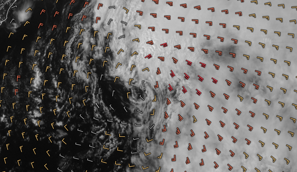
Notice the high clouds on the northern side starting to fan out to the NW, The upper low is starting to cut off. shear on the next analysis show show a significant drop.
0 likes
Note: If I make a post that is brief. Please refer back to previous posts for the analysis or reasoning. I do not re-write/qoute what my initial post said each time.
If there is nothing before... then just ask
Space & Atmospheric Physicist, Embry-Riddle Aeronautical University,
I believe the sky is falling...
If there is nothing before... then just ask
Space & Atmospheric Physicist, Embry-Riddle Aeronautical University,
I believe the sky is falling...
Who is online
Users browsing this forum: No registered users and 98 guests